HURAKAN wrote:
Late Season Development W. Carib. (Is invest 91L)
Moderator: S2k Moderators
Forum rules

The posts in this forum are NOT official forecasts and should not be used as such. They are just the opinion of the poster and may or may not be backed by sound meteorological data. They are NOT endorsed by any professional institution or STORM2K. For official information, please refer to products from the National Hurricane Center and National Weather Service.
Re:
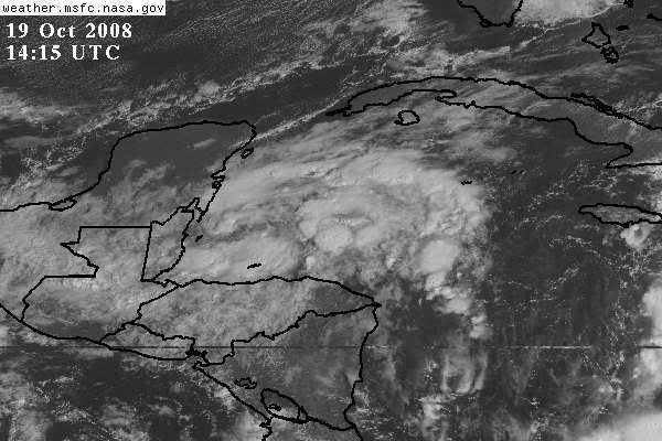
To the untrained eye, definitely a bit more organization this am...amateur opinion is that this is something to keep an eye on....has 'that look', at least right now....a definite 'stay tuned'
0 likes
-
wxman57

- Moderator-Pro Met

- Posts: 23122
- Age: 68
- Joined: Sat Jun 21, 2003 8:06 pm
- Location: Houston, TX (southwest)
Re: Late Season Development W. Carib. GFS & CMC
Taking a look at the forecasts by the GFS, ECMWF and Canadian, it's clear that they all agree on a general scenario for the coming week. A very deep mid to upper-level low will move eastward across the south-central U.S. by Thursday. A southwesterly jet digging down to the southern Gulf/NW Caribbean may pick up whatever is down there and take it NE toward Florida on Thursday/Friday. Canadian is farthest west with the low center, moving it into the FL Panhandle. GFS is farthest east bringing it into south Florida. EC has been in the middle.
So, "something" is likely to come out of the NW Caribbean and impact Florida on Friday, but what? Looking at the projected upper level winds across the eastern Gulf, the GFS is forecasting westerly winds at 70-80 kts at 250mb across the east-central Gulf and 30-40 kts across the southern Gulf. Not exactly the kind of flow that's favorable for a purely tropical low center. Even if the low would start out tropical, it would likely be a sheared system with an exposed center west of any convection by the time it reached Florida under such upper-level winds. Perhaps a hybrid/subtropical low. Such lows can produce 50kt winds but hurricane development would be unlikely. At least, a hurricane impact on Florida given the upper-level winds would be unlikely. The only chance of that (hurricane impact) might be a track very far south across Cuba to the Bahamas, perhaps clipping the Keys. That may keep the low center far enough to the south away from the strong westerly winds aloft.
What I think is most likely is that a TD or TS will form in the NW Caribbean in 2-3 days. It gets picked up by the approaching front/upper trof Thursday and driven across Florida as it merges with the cold front on Friday. Probably not a big wind factor across Florida - it would just enhance the rain ahead of the front.
0 likes
-
Tampa Bay Hurricane

- Category 5

- Posts: 5598
- Age: 38
- Joined: Fri Jul 22, 2005 7:54 pm
- Location: St. Petersburg, FL
The posts in this forum are NOT official forecast and should not be used as such. They are just the opinion of the poster and may or may not be backed by sound meteorological data. They are NOT endorsed by any professional institution or storm2k.org. For official information, please refer to the NHC and NWS products.
It looks more organized this morning, and the convection is
impressive. This is based on the latest satellite image. I think
this may become a tropical depression by tomorrow or even later
today.
Long term- I agree with wxman57, a sheared hybrid tropical system
moving across the Florida peninsula by Thursday, mainly with rain
and the wind may be 40-50 mph if the low is deep enough.
The only chance for this to impact Florida/Cuba/Bahamas as a hurricane is if it somehow reaches hurricane strength over the very high heat content waters of the caribbean and is of at least category 2 so that once it moves into the gulf of mexico
the shear brings intensity down but not below hurricane strength. Now this
is possible given it has nearly 4 days over the highest heat content water in the
basin. I'm not forecasting a hurricane, because there are many uncertainties,
but it is possible.
0 likes
-
CourierPR

- Category 5
- Posts: 1336
- Age: 71
- Joined: Tue Aug 31, 2004 7:53 pm
- Location: Pompano Beach, Florida
Re: Late Season Development W. Carib. GFS & CMC
Hurakan, what are your thoughts on this system?
0 likes
Re:
Sometimes these sub-tropical type systems can have much broader wind fields than a pure tropical system.....a case of a larger area of ts winds vs. a tight central core of strong winds in an eyewall.
The rain would not be a bad thing for Florida...it hasn't been very wet lately and we are approacing the dry season. Tropical storm force winds are not going to do alot of overall damage, but they are certainly a nuisance and can impact an area with downed trees and powerlines.
One question I have had is that Wilma actually brought a cold front through south florida on her backside....unusually dry air for the time of year....literally with in 2 or 3 hours after experiencing sustained cat 2 conditions here in fort lauderdale. How is that given the shear and hostile conditions that would seem to be the case given that set-up, Wilma still strengthened pretty much her entire journey from emerging off the Yucatan to landfall in Florida? Was this set-up a factor in the huge windfield she brought with her....the radius of hurricane force winds at landfall in florida ranked right up there with Katrina.
Tampa Bay Hurricane wrote:The posts in this forum are NOT official forecast and should not be used as such. They are just the opinion of the poster and may or may not be backed by sound meteorological data. They are NOT endorsed by any professional institution or storm2k.org. For official information, please refer to the NHC and NWS products.
It looks more organized this morning, and the convection is
impressive. This is based on the latest satellite image. I think
this may become a tropical depression by tomorrow or even later
today.
Long term- I agree with wxman57, a sheared hybrid tropical system
moving across the Florida peninsula by Thursday, mainly with rain
and the wind may be 40-50 mph if the low is deep enough.
The only chance for this to impact Florida/Cuba/Bahamas as a hurricane is if it somehow reaches hurricane strength over the very high heat content waters of the caribbean and is of at least category 2 so that once it moves into the gulf of mexico
the shear brings intensity down but not below hurricane strength. Now this
is possible given it has nearly 4 days over the highest heat content water in the
basin. I'm not forecasting a hurricane, because there are many uncertainties,
but it is possible.
0 likes
Re:
Having 80+ degree water all the way to the coast in florida would not be a weakening factor to, say, compound any shear or other hostile atmospheric conditions that may exist either.
Tampa Bay Hurricane wrote:The posts in this forum are NOT official forecast and should not be used as such. They are just the opinion of the poster and may or may not be backed by sound meteorological data. They are NOT endorsed by any professional institution or storm2k.org. For official information, please refer to the NHC and NWS products.
It looks more organized this morning, and the convection is
impressive. This is based on the latest satellite image. I think
this may become a tropical depression by tomorrow or even later
today.
Long term- I agree with wxman57, a sheared hybrid tropical system
moving across the Florida peninsula by Thursday, mainly with rain
and the wind may be 40-50 mph if the low is deep enough.
The only chance for this to impact Florida/Cuba/Bahamas as a hurricane is if it somehow reaches hurricane strength over the very high heat content waters of the caribbean and is of at least category 2 so that once it moves into the gulf of mexico
the shear brings intensity down but not below hurricane strength. Now this
is possible given it has nearly 4 days over the highest heat content water in the
basin. I'm not forecasting a hurricane, because there are many uncertainties,
but it is possible.
0 likes
-
HURAKAN

- Professional-Met

- Posts: 46086
- Age: 38
- Joined: Thu May 20, 2004 4:34 pm
- Location: Key West, FL
- Contact:
Re: Late Season Development W. Carib. GFS & CMC
CourierPR wrote:Hurakan, what are your thoughts on this system?
Code: Select all
The posts in this forum are NOT official forecast and should not be used as such. They are just the opinion of the poster and may or may not be backed by sound meteorological data. They are NOT endorsed by any professional institution or storm2k.org. For official information, please refer to the NHC and NWS products.Upper level conditions appear to be mostly favorable for development and the WCAR is the place for development late in the season. I think it has a very good shot at development before the cold front arrives by mid to late next week. Intensity-wise? It will depend how fast it develops. If it takes too long, I wouldn't expect much more than a tropical storm. But if it develops by tomorrow or Tuesday, then we may see it reach hurricane status due to the high SSTs in the area. Omar is an example of how tricky intensity can be.

0 likes

-
Epsilon_Fan

- Category 1

- Posts: 353
- Joined: Fri Jan 13, 2006 1:03 pm
- Location: Charleston, SC
Re: Late Season Development W. Carib. GFS & CMC
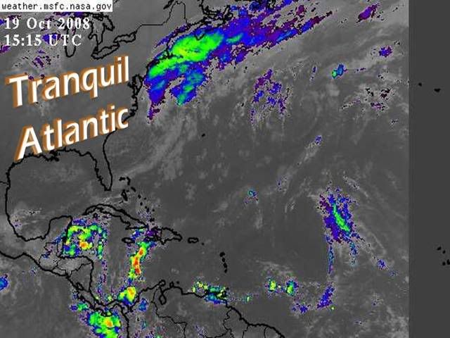
The developing rotation is evident on the sat images. Shouldn't this be worthy of a code orange yet?
0 likes

Re: Late Season Development W. Carib. GFS & CMC
Somewhat of a different take on this system from Dr. Jeff Masters this afternoon:
An area of disturbed weather associated with a large area of low pressure has developed over the Western Caribbean Sea. This is not a reincarnation of Tropical Depression 16, but does have some of the moisture from that storm. The intensity and areal coverage of heavy thunderstorms in the disturbance has slowly increased over the past day (Figure 1). Wind shear is a high 20 knots, and is expected to remain in the 15-25 knot range over the next four days. This may allow some slow development of the disturbance. None of the computer models develop the disturbance, and NHC is giving it a low (<20% chance) of developing into a tropical depression by Tuesday. A slow west-northwestward motion across the Yucatan Peninsula is expected to begin by Wednesday, and the disturbance will bring heavy rains of 3-6 inches to Belize and Mexico's Yucatan over the next three days.
http://www.wunderground.com/blog/JeffMasters/comment.html?entrynum=1132&tstamp=200810
0 likes


Re: Late Season Development W. Carib. GFS & CMC
According to Jeff Masters report this system like td #16 will not affect Florida. I disagree with that statement, a potent trough is expected to develop in the plains states that would pull this energy north or NE towards Florida.
0 likes
-
wxman57
- Moderator-Pro Met
- Posts: 23122
- Age: 68
- Joined: Sat Jun 21, 2003 8:06 pm
- Location: Houston, TX (southwest)
Re: Late Season Development W. Carib. GFS & CMC
Epsilon_Fan wrote:The developing rotation is evident on the sat images. Shouldn't this be worthy of a code orange yet?
If you look at a water vapor loop you'll see strong SW-WSW winds aloft digging down into the northwest Caribbean now. Upper-level winds down there won't be very favorable for any spin up for another few days. I don't see anything that indicates this could be a depression in the next 24 hours. Most likely late Tuesday or Wednesday at the earliest. That's beyond the NHC's 48 hour outlook time.
0 likes
Re: Late Season Development W. Carib. GFS & CMC
It seems like a pretty big change in thinking for Dr. Masters from yesterday when he was going with a Florida scenario of some system being possible.....unless he didn't go into what could happen as far as movement after trekking across the Yucatan.
boca wrote:According to Jeff Masters report this system like td #16 will not affect Florida. I disagree with that statement, a potent trough is expected to develop in the plains states that would pull this energy north or NE towards Florida.
0 likes
Re: Late Season Development W. Carib. GFS & CMC
Wxman57 thinks this system will head to Florida too.Read this post above 
0 likes
Who is online
Users browsing this forum: No registered users and 59 guests