Low Pressure in Gulf of Mexico

This is the general tropical discussion area. Anyone can take their shot at predicting a storms path.

Moderator: S2k Moderators

Forum rules

The posts in this forum are NOT official forecasts and should not be used as such. They are just the opinion of the poster and may or may not be backed by sound meteorological data. They are NOT endorsed by any professional institution or STORM2K. For official information, please refer to products from the National Hurricane Center and National Weather Service.

Help Support Storm2K
Message
Author
User avatar
HurricaneGirl
Category 5
Category 5
Posts: 5839
Age: 60
Joined: Thu Feb 06, 2003 9:45 am
Location: Clare, Michigan
Contact:

Re: Low Pressure at Fla Peninsula / EGOM / Model runs

#81 Postby HurricaneGirl » Tue May 19, 2009 5:17 pm

tina25 wrote:
TropicalWXMA wrote:Can you take a picture and post it? I'm interested to see what the sky looks like!

tina25 wrote:I'm in the Naples/Ft. Myers area and there is zero wind here. Clouds inland and north of me look very bizarre.


This is looking towards the north. I was out running errands earlier and I noticed how dark it looked inland. Just started pouring here.

Image

Image


Nice shots~~ 8-)
0 likes   

User avatar
ROCK
Category 5
Category 5
Posts: 9484
Age: 54
Joined: Tue Aug 17, 2004 7:30 am
Location: Kemah, Texas

Re: Low Pressure at Fla Peninsula / EGOM / Model runs

#82 Postby ROCK » Tue May 19, 2009 5:21 pm

I have to agree with a weak low trying to spin up south of Tampa...clearly see this in this shot....devoid of convection though
0 likes   

User avatar
ROCK
Category 5
Category 5
Posts: 9484
Age: 54
Joined: Tue Aug 17, 2004 7:30 am
Location: Kemah, Texas

Re: Low Pressure at Fla Peninsula / EGOM / Model runs

#83 Postby ROCK » Tue May 19, 2009 5:25 pm

0 likes   

User avatar
HURAKAN
Professional-Met
Professional-Met
Posts: 46086
Age: 38
Joined: Thu May 20, 2004 4:34 pm
Location: Key West, FL
Contact:

#84 Postby HURAKAN » Tue May 19, 2009 5:47 pm

Image

Large disturbed area.
0 likes   

Aric Dunn
Category 5
Category 5
Posts: 21238
Age: 42
Joined: Sun Sep 19, 2004 9:58 pm
Location: Ready for the Chase.
Contact:

Re: Low Pressure at Fla Peninsula / EGOM / Model runs

#85 Postby Aric Dunn » Tue May 19, 2009 6:01 pm

hehe.. the remnants of 90L is circled in the image below.. been tracking it still has some circ to it.. lol probably some gusty winds to the central florida area..
you can see the leftover spin on long range radar people who have GR it shows up better. also in base velocity you can see the signature.. kind of funny i think.. lol

Image
0 likes   

Aric Dunn
Category 5
Category 5
Posts: 21238
Age: 42
Joined: Sun Sep 19, 2004 9:58 pm
Location: Ready for the Chase.
Contact:

#86 Postby Aric Dunn » Tue May 19, 2009 6:07 pm

also check out the winds out at the 120 mile bouy ..!!! which is right in the middle of the remnants.

http://www.ndbc.noaa.gov/station_page.php?station=41010
nearly sustained TS force.. lol

that will all come ashore somewhere in central florida looks like just north of the cape..
0 likes   

Bailey1777
S2K Supporter
S2K Supporter
Posts: 962
Joined: Mon Jul 31, 2006 6:23 pm
Location: Houston, Texas

Re: Low Pressure at Fla Peninsula / EGOM / Model runs

#87 Postby Bailey1777 » Tue May 19, 2009 6:46 pm

Aric, what will happen when ex 90L catches up with the circulation taking shape near the west Florida coast?
0 likes   

Aric Dunn
Category 5
Category 5
Posts: 21238
Age: 42
Joined: Sun Sep 19, 2004 9:58 pm
Location: Ready for the Chase.
Contact:

Re: Low Pressure at Fla Peninsula / EGOM / Model runs

#88 Postby Aric Dunn » Tue May 19, 2009 6:49 pm

Bailey1777 wrote:Arik, what will happen when ex 90L catches up with the circulation taking shape near the west Florida coast?

nothing.. it will be absorbed.. completely .. pretty much is already.. :)
0 likes   

User avatar
Category 5
Category 5
Category 5
Posts: 10074
Age: 35
Joined: Sun Feb 11, 2007 10:00 pm
Location: New Brunswick, NJ
Contact:

Re: Low Pressure at Fla Peninsula / EGOM / Model runs

#89 Postby Category 5 » Tue May 19, 2009 7:00 pm

the air in the gulf is cool and very dry, way too much for any tropical (maybe even subtropical) development IMO. Anything that forms I think will be extratropical (it might even get choked out and dissipate)

If we had moist air out there, THEN we'd have something to talk about.
0 likes   

Aric Dunn
Category 5
Category 5
Posts: 21238
Age: 42
Joined: Sun Sep 19, 2004 9:58 pm
Location: Ready for the Chase.
Contact:

Re: Low Pressure at Fla Peninsula / EGOM / Model runs

#90 Postby Aric Dunn » Tue May 19, 2009 7:08 pm

Category 5 wrote:the air in the gulf is cool and very dry, way too much for any tropical (maybe even subtropical) development IMO. Anything that forms I think will be extratropical (it might even get choked out and dissipate)

If we had moist air out there, THEN we'd have something to talk about.


well its not going anywhere anytime soon and well anytime you have a surface low over warm water (warm meaning the gulf loop rest gulf just marginal) you have to keep watching ... until its gone there is always a chance ..
0 likes   

User avatar
HURAKAN
Professional-Met
Professional-Met
Posts: 46086
Age: 38
Joined: Thu May 20, 2004 4:34 pm
Location: Key West, FL
Contact:

#91 Postby HURAKAN » Tue May 19, 2009 7:30 pm

Image
0 likes   

User avatar
TropicalWXMA
Tropical Storm
Tropical Storm
Posts: 114
Joined: Wed May 18, 2005 9:22 pm
Location: Boston, MA
Contact:

Re:

#92 Postby TropicalWXMA » Tue May 19, 2009 7:43 pm

That is one SEXY lookin' image. :cheesy:

HURAKAN wrote:Image
0 likes   

Aric Dunn
Category 5
Category 5
Posts: 21238
Age: 42
Joined: Sun Sep 19, 2004 9:58 pm
Location: Ready for the Chase.
Contact:

#93 Postby Aric Dunn » Tue May 19, 2009 7:44 pm

lol...
0 likes   

User avatar
HURAKAN
Professional-Met
Professional-Met
Posts: 46086
Age: 38
Joined: Thu May 20, 2004 4:34 pm
Location: Key West, FL
Contact:

#94 Postby HURAKAN » Tue May 19, 2009 7:47 pm

Image

TROPICAL WEATHER DISCUSSION
NWS TPC/NATIONAL HURRICANE CENTER MIAMI FL
805 PM EDT TUE MAY 19 2009

GULF OF MEXICO...
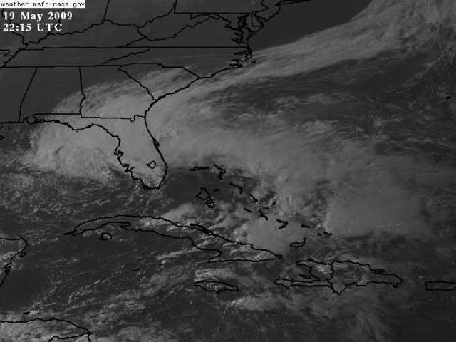
AS OF 2100 UTC...A WARM FRONT EXTENDS ACROSS THE FLORIDA
PENINSULA FROM S OF JACKSONVILLE THROUGH TAMPA INTO A 1007 MB
LOW NEAR NAPLES. A SURFACE TROUGH EXTENDS S FROM THE LOW ACROSS
THE ERN FLORIDA STRAITS TO OVER CENTRAL CUBA AND INTO THE WRN
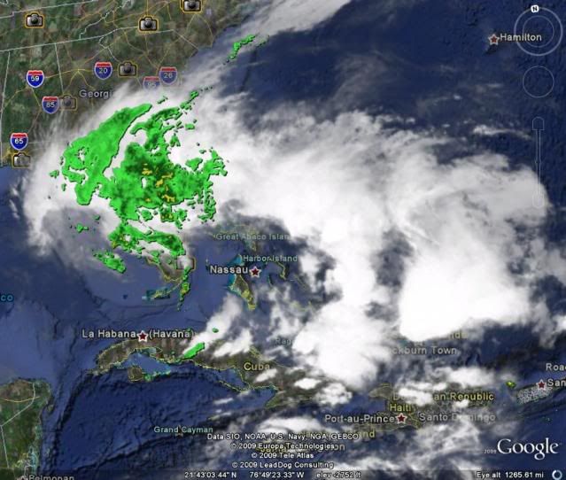
CARIBBEAN. DOPPLER RADAR MOSAIC AND LIGHTNING DATA INDICATES
NUMEROUS SHOWERS AND ISOLATED TSTMS ACROSS MUCH OF FLORIDA AND
MUCH OF THE E GULF NE OF A LINE FROM KEY WEST FLORIDA TO
GULFPORT MISSISSIPPI. ALL OF THIS ACTIVITY IS BEING DRIVEN FROM
A MIDDLE TO UPPER LEVEL LOW CENTERED NEAR 26N85W WITH A
EXPANSIVE AREA OF UPPER DIFFLUENCE ACROSS THE NE GULF...FLORIDA
PENINSULA AND INTO THE W ATLC. AS THE SURFACE LOW DEVELOPS OVER
THE NEXT 24 HOURS AND MOVES INTO THE CENTRAL GULF STRONG NE
WINDS TO GALE FORCE ARE EXPECTED N OF 28N E OF 85W. A NARROW
SURFACE RIDGE OF HIGH PRESSURE WILL REMAIN IN PLACE ACROSS THE
WRN GULF AND GRADUALLY WEAKEN THROUGH FRIDAY.
0 likes   

tina25
Tropical Depression
Tropical Depression
Posts: 62
Joined: Mon Sep 01, 2008 10:53 pm
Location: NYC

Re:

#95 Postby tina25 » Tue May 19, 2009 7:52 pm

HURAKAN wrote:Image


You may want to remove the image if that is your address peeking through the clouds. There are some crazies out there.
0 likes   

User avatar
cycloneye
Admin
Admin
Posts: 145631
Age: 68
Joined: Thu Oct 10, 2002 10:54 am
Location: San Juan, Puerto Rico

Re: Low Pressure at Fla Peninsula / EGOM / Model runs

#96 Postby cycloneye » Tue May 19, 2009 8:55 pm

0 likes   

User avatar
gatorcane
S2K Supporter
S2K Supporter
Posts: 23692
Age: 47
Joined: Sun Mar 13, 2005 3:54 pm
Location: Boca Raton, FL

#97 Postby gatorcane » Tue May 19, 2009 9:19 pm

Winds are pretty impressive in the Eastern Gulf of Mexico (out over the open water) with gale force gusts. Here is an example:

Buoy 42036 - 106NM WNW of Tampa - NNE winds 31.1Kt gusts to 38.9kt

http://www.ndbc.noaa.gov/

Storm totals are even more impressive from this system with areas in NE FL near 1 ft of rain:

http://radar.weather.gov/radar.php?rid= ... 11&loop=no
0 likes   

Aric Dunn
Category 5
Category 5
Posts: 21238
Age: 42
Joined: Sun Sep 19, 2004 9:58 pm
Location: Ready for the Chase.
Contact:

Re:

#98 Postby Aric Dunn » Tue May 19, 2009 9:27 pm

gatorcane wrote:Winds are pretty impressive in the Eastern Gulf of Mexico (out over the open water) with gale force gusts. Here is an example:

Buoy 42036 - 106NM WNW of Tampa - NNE winds 31.1Kt gusts to 38.9kt

http://www.ndbc.noaa.gov/

Storm totals are even more impressive from this system with areas in NE FL near 1 ft of rain:

http://radar.weather.gov/radar.php?rid= ... 11&loop=no


yes which is my area.. :)

remnants 90L coming ashore soon hehe...
0 likes   

User avatar
wxman57
Moderator-Pro Met
Moderator-Pro Met
Posts: 22984
Age: 67
Joined: Sat Jun 21, 2003 8:06 pm
Location: Houston, TX (southwest)

Re: Low Pressure at Fla Peninsula / EGOM / Model runs

#99 Postby wxman57 » Tue May 19, 2009 9:32 pm

That's all cool, dry air spilling out across the Gulf. With cool air over warm water, the wind offshore will be about twice that of over the land to the north. I think there will be too much cool and dry air flowing into this system for any significant development. Eventually, it should just spin down with decreasing convection, or it'll move inland on Friday/Saturday.
0 likes   

User avatar
AdamFirst
S2K Supporter
S2K Supporter
Posts: 2491
Age: 36
Joined: Thu Aug 14, 2008 10:54 am
Location: Port Saint Lucie, FL

#100 Postby AdamFirst » Tue May 19, 2009 9:47 pm

Mostly the east coast south of Vero Beach is high and dry, save an occasional cell or two.

With the ex-90L converging with this new low pressure spinning on the west coast, is there any chance that South Florida gets any more substantial rain?

I would prefer the constant soaking Daytona Beach has gotten rather than having drive-by showers.
0 likes   


Return to “Talkin' Tropics”

Who is online

Users browsing this forum: Hurricane2022, jconsor, Ulf and 55 guests