Saw the video. No changes from April video. Forecasts 16-18 named storms, 15 west of 55W. Of those 16-18 named storms, 6 storms (TS or greater) passing near or striking the U.S., 2 of those major hurricanes. Congregation of tracks across the northern Caribbean Islands then either turning north (SE U.S.) or heading into the Gulf.
That all seems reasonable.
Joe Bastardi: 16-18 named storms, top 10 year
Moderator: S2k Moderators
Forum rules

The posts in this forum are NOT official forecasts and should not be used as such. They are just the opinion of the poster and may or may not be backed by sound meteorological data. They are NOT endorsed by any professional institution or STORM2K. For official information, please refer to products from the National Hurricane Center and National Weather Service.


I think probably biggest risk this season would be E.Caribbean, Nova Scotia (for those that recurve, though an upper high will probably keep that area fairly safe for the most part...) Florida, E.Gulf through to NO and then another area near the Yucatan....Yucatan could be prime location if the La Nina gets strong enough IMO.
0 likes
Personal Forecast Disclaimer:
The posts in this forum are NOT official forecast and should not be used as such. They are just the opinion of the poster and may or may not be backed by sound meteorological data. They are NOT endorsed by any professional institution or storm2k.org. For official information, please refer to the NHC and NWS products
The posts in this forum are NOT official forecast and should not be used as such. They are just the opinion of the poster and may or may not be backed by sound meteorological data. They are NOT endorsed by any professional institution or storm2k.org. For official information, please refer to the NHC and NWS products
-
SETXWXLADY
- Tropical Storm

- Posts: 216
- Joined: Wed May 20, 2009 3:26 pm
- Location: SE TX Orange County
Re: Joe Bastardi: More Active 2010 Hurricane Season
[quote="BigA"]A couple of pieces of not-so-light reading, but that I think touch upon the NAO hurricane track relationship. All three of them seem to say that a negative NAO correlates with storms not recurving, but please read it for yourself and correct me if I am in error.
http://journals.ametsoc.org/doi/full/10.1175/JCLI3560.1
garnet.acns.fsu.edu/~jelsner/PDF/Research/LongLead.pdf
soundwaves.usgs.gov/2005/04/Bossakarticle.pdf
From the last work
"A weaker North Atlantic Oscillation is associated with a greater chance of major hurricane landfalls along the Gulf Coast of the U.S. [Elsner and Bossak, 2004]. Hurricanes that form off Africa and move at low latitudes to the west to make landfall on the U.S. coast south of the North Carolina border are termed straight-moving (SM) hurricanes [Elsner, 2003] and these SM hurricanes are also significantly correlated with a weaker NAO. The NAO values from May (-0.67) and June (-0.38) (These values are from 2004, I think) are moderately negative, suggesting a weakening of the NAO. The NAO has specific effects upon the Bermuda High pressure system in the Atlantic Ocean. A positive (strong) NAO results in the Bermuda High being shifted more to the east and intensifying, allowing for greater recurvature of North Atlantic hurricanes, and resulting in only an occasional landfall in the U.S. northeast [Elsner et al., 2001]. In contrast, a negative (weak) NAO allows for a more westward Bermuda High, which acts to steer North Atlantic hurricanes toward the southern U.S."[/quote]
That's the way I learned it, read it, etc. I've only been at this a couple years. After Rita, Humberto, and Edouard I tried my best to find out why they come here. And a negative NAO is sometimes the culprit. That's why that's stuck in my head. Of course I could be wrong. wxman may be right. Right now I'm just confused. Will try to find out where I read all that tomorrow- uh later today.
0 likes
-
hurricanetrack

- HurricaneTrack.com

- Posts: 1781
- Joined: Tue Dec 02, 2003 10:46 pm
- Location: Wilmington, NC
- Contact:
Interesting that Joe points out this morning that Brian Maue at FSU is NOT calling for as busy a season as Accuweather or CSU.
http://www.coaps.fsu.edu/~maue/tropical/
Does not really say why- just that the SH tropical cyclone season was average.
http://www.coaps.fsu.edu/~maue/tropical/
Does not really say why- just that the SH tropical cyclone season was average.
0 likes
-
wxman57

- Moderator-Pro Met

- Posts: 23121
- Age: 68
- Joined: Sat Jun 21, 2003 8:06 pm
- Location: Houston, TX (southwest)
Re: Joe Bastardi: More Active 2010 Hurricane Season
I think that the author of that 3rd paper in the links above has it backwards when he states:
"The NAO has specific effects upon the Bermuda High pressure system in the Atlantic Ocean. A positive (strong) NAO results in the Bermuda High being shifted more to the east and intensifying, allowing for greater recurvature of North Atlantic hurricanes, and resulting in only an occasional landfall in the U.S. northeast [Elsner et al., 2001]. In contrast, a negative (weak) NAO allows for a more westward Bermuda High, which acts to steer North Atlantic hurricanes toward the southern U.S. Figure 2 demonstrates several factors likely to be influencing the track of this year’s U.S. hurricanes, including the position of the Bermuda High. (NAO data."
A negative NAO occurs when the trof along/off the east U.S. coast is deeper/stronger. This results in a farther EAST displacement of the Bermuda high (not farther west). Figure 2 in the author's paper is most definitely an example of a Positive NAO. It's easy to get confused. This can clearly be seen in the examples on the NAO website:
Negative NAO - Note the weaker and farther EAST Bermuda High:
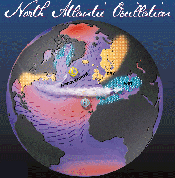
Now, look at the Positive NAO - Stronger Bermuda High shifted farther west:
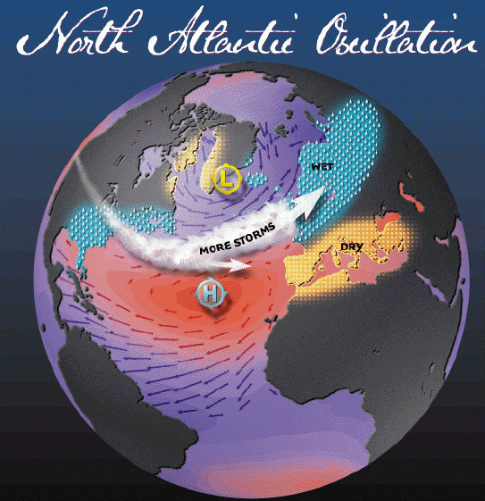
NAO website:
http://www.ldeo.columbia.edu/res/pi/NAO/
From the website:
"Positive NAO Index
The Positive NAO index phase shows a stronger than usual subtropical high pressure center and a deeper than normal Icelandic low.
Negative NAO Index
The negative NAO index phase shows a weak subtropical high and a weak Icelandic low."
Basically, with a negative NAO, the Icelandic low IS weaker - it's shifted south and west, deepening the trof off the east U.S. coast. Bermuda High is weaker and located farther to the east. This results in weaker easterly trade winds, meaning less low-level shear in the deep tropics and less upwelling of cold water.
So a Negative NAO should allow more storms to recurve east of the U.S., not drive them westward toward the U.S. But there will be times when the east coast trof weakens and/or a TC forms farther westward (in the very favorable for development Caribbean) so there will still be a high risk of impact across the U.S. There will just be less of a chance that a Cape Verde storm will make it all the way across to the Gulf.
"The NAO has specific effects upon the Bermuda High pressure system in the Atlantic Ocean. A positive (strong) NAO results in the Bermuda High being shifted more to the east and intensifying, allowing for greater recurvature of North Atlantic hurricanes, and resulting in only an occasional landfall in the U.S. northeast [Elsner et al., 2001]. In contrast, a negative (weak) NAO allows for a more westward Bermuda High, which acts to steer North Atlantic hurricanes toward the southern U.S. Figure 2 demonstrates several factors likely to be influencing the track of this year’s U.S. hurricanes, including the position of the Bermuda High. (NAO data."
A negative NAO occurs when the trof along/off the east U.S. coast is deeper/stronger. This results in a farther EAST displacement of the Bermuda high (not farther west). Figure 2 in the author's paper is most definitely an example of a Positive NAO. It's easy to get confused. This can clearly be seen in the examples on the NAO website:
Negative NAO - Note the weaker and farther EAST Bermuda High:
Now, look at the Positive NAO - Stronger Bermuda High shifted farther west:
NAO website:
http://www.ldeo.columbia.edu/res/pi/NAO/
From the website:
"Positive NAO Index
The Positive NAO index phase shows a stronger than usual subtropical high pressure center and a deeper than normal Icelandic low.
Negative NAO Index
The negative NAO index phase shows a weak subtropical high and a weak Icelandic low."
Basically, with a negative NAO, the Icelandic low IS weaker - it's shifted south and west, deepening the trof off the east U.S. coast. Bermuda High is weaker and located farther to the east. This results in weaker easterly trade winds, meaning less low-level shear in the deep tropics and less upwelling of cold water.
So a Negative NAO should allow more storms to recurve east of the U.S., not drive them westward toward the U.S. But there will be times when the east coast trof weakens and/or a TC forms farther westward (in the very favorable for development Caribbean) so there will still be a high risk of impact across the U.S. There will just be less of a chance that a Cape Verde storm will make it all the way across to the Gulf.
0 likes
Ah but that depends greatly on the exact type of -ve NAO Wxman57...
The reason I say this is there is a BIG difference synoptically between an east based -ve NAO which features a patternc close to what you are talking about, and a west based -ve NAO which promotes higher pressure over Canada.
The east based version is more common but interestingly the CFS is really rather keen on a west based -ve NAO this summer with the main upper high centered closer to Canada.
A classic east based -ve NAO month would be September 2006, I've not found a classic west based -ve NAO on the archieves yet in the summer, but it wouldn't surprise me to find out that alot of storms make landfall when the NAO shifts from a west based -ve NAO to a positive NAO.
0 likes
Personal Forecast Disclaimer:
The posts in this forum are NOT official forecast and should not be used as such. They are just the opinion of the poster and may or may not be backed by sound meteorological data. They are NOT endorsed by any professional institution or storm2k.org. For official information, please refer to the NHC and NWS products
The posts in this forum are NOT official forecast and should not be used as such. They are just the opinion of the poster and may or may not be backed by sound meteorological data. They are NOT endorsed by any professional institution or storm2k.org. For official information, please refer to the NHC and NWS products
-
wxman57
- Moderator-Pro Met
- Posts: 23121
- Age: 68
- Joined: Sat Jun 21, 2003 8:06 pm
- Location: Houston, TX (southwest)
Re:
KWT wrote:Ah but that depends greatly on the exact type of -ve NAO Wxman57...
The reason I say this is there is a BIG difference synoptically between an east based -ve NAO which features a patternc close to what you are talking about, and a west based -ve NAO which promotes higher pressure over Canada.
The east based version is more common but interestingly the CFS is really rather keen on a west based -ve NAO this summer with the main upper high centered closer to Canada.
A classic east based -ve NAO month would be September 2006, I've not found a classic west based -ve NAO on the archieves yet in the summer, but it wouldn't surprise me to find out that alot of storms make landfall when the NAO shifts from a west based -ve NAO to a positive NAO.
Had never heard of the NAO being classified as -ve. Did find a paper by TSR which mentioned the -ve NAO and +ve NAO. But the graphics are identical to the ones I posted for a "standard" negative or positive NAO. I don't think that there is any difference by putting a "ve" in front of the NAO.
http://www.tropicalstormrisk.com/docs/U ... ecture.pdf

I do think that there is a significantly increased risk of an impact from SE LA to NC, centered on Florida this year. But I also think that most of the true Cape Verde storms will recurve east of the U.S. this season.
0 likes
Without a doubt they are the same thing Wxman57...
However the difference is whether a block can be east or west based, much in the same way you can have a west and east based El Nino.
As I said, you can have various versions of a negative NAO. If you have a west based negative NAO then whilst the index will still be negative, the main block will be focused over W.Greenland through to Canada and thus that clearly allows a more condusive path for storms, esp if they can get past any weaknesses earlier down the path.
An east based -ve NAO signal will call for the upper high to be centered further east with the block centered over Iceland and sometimes as far east as Scandinavia.
Obviously these will have various pattern difference in the Atlantic.
Thus all I'm saying with that is you can't totally broadbrush the NAO, the exact location of where the block ends up is clearly going to play a much bigger role then simply the NAO...
That said, I can't disagree either, I feel there will be a significant weakness in the Atlantic for CV storms to go through, my main concern is it sets-up too far west and really brings the Caribbean into play.
0 likes
Personal Forecast Disclaimer:
The posts in this forum are NOT official forecast and should not be used as such. They are just the opinion of the poster and may or may not be backed by sound meteorological data. They are NOT endorsed by any professional institution or storm2k.org. For official information, please refer to the NHC and NWS products
The posts in this forum are NOT official forecast and should not be used as such. They are just the opinion of the poster and may or may not be backed by sound meteorological data. They are NOT endorsed by any professional institution or storm2k.org. For official information, please refer to the NHC and NWS products
-
Blown Away

- S2K Supporter

- Posts: 10253
- Joined: Wed May 26, 2004 6:17 am
Re: Joe Bastardi: More Active 2010 Hurricane Season
With negative NAO don't we generally see a weaker Azores high and a stronger Bermuda high that is positioned more towards the west? I think that is what JB sees, most of the activity west of 55 which would put developing systems under the west positioned BH??
0 likes
Hurricane Eye Experience: David 79, Irene 99, Frances 04, Jeanne 04, Wilma 05… Hurricane Brush Experience: Andrew 92, Erin 95, Floyd 99, Matthew 16, Irma 17, Ian 22, Nicole 22…
-
wxman57
- Moderator-Pro Met
- Posts: 23121
- Age: 68
- Joined: Sat Jun 21, 2003 8:06 pm
- Location: Houston, TX (southwest)
Re: Joe Bastardi: More Active 2010 Hurricane Season
Blown Away wrote:With negative NAO don't we generally see a weaker Azores high and a stronger Bermuda high that is positioned more towards the west? I think that is what JB sees, most of the activity west of 55 which would put developing systems under the west positioned BH??
No, he's not differentiating two high centers. A negative NAO means that the Icelandic low is displaced southward with a trof extending to off or along the East U.S. Coast. The Azores-Bermuda High is displaced eastward and is weaker.
This will allow a number (majority) of CV storms to recurve east of the U.S. However, the pattern isn't unchanging. At times, the East Coast Trof will be weaker, allowing for farther west recurvature of CV storms. In addition, a number of storms will likely develop in the Caribbean. These will very likely be a U.S. threat.
0 likes
-
cycloneye

- Admin

- Posts: 148734
- Age: 69
- Joined: Thu Oct 10, 2002 10:54 am
- Location: San Juan, Puerto Rico
Re: Joe Bastardi: More Active 2010 Hurricane Season
Here is the graphic that shows what JB is forecasting in area sections from 55W and westward.

0 likes
Visit the Caribbean-Central America Weather Thread where you can find at first post web cams,radars
and observations from Caribbean basin members Click Here
and observations from Caribbean basin members Click Here
-
Blown Away
- S2K Supporter
- Posts: 10253
- Joined: Wed May 26, 2004 6:17 am
Re: Joe Bastardi: More Active 2010 Hurricane Season
wxman57 wrote:Blown Away wrote:With negative NAO don't we generally see a weaker Azores high and a stronger Bermuda high that is positioned more towards the west? I think that is what JB sees, most of the activity west of 55 which would put developing systems under the west positioned BH??
No, he's not differentiating two high centers. A negative NAO means that the Icelandic low is displaced southward with a trof extending to off or along the East U.S. Coast. The Azores-Bermuda High is displaced eastward and is weaker.
This will allow a number (majority) of CV storms to recurve east of the U.S. However, the pattern isn't unchanging. At times, the East Coast Trof will be weaker, allowing for farther west recurvature of CV storms. In addition, a number of storms will likely develop in the Caribbean. These will very likely be a U.S. threat.
I read this has been one of the strongest NAO's in in decades keeping the Bermuda/Azores high very weak. I wonder if the high will rebound to influence more storms west during the heart of the hurricane season.
0 likes
Hurricane Eye Experience: David 79, Irene 99, Frances 04, Jeanne 04, Wilma 05… Hurricane Brush Experience: Andrew 92, Erin 95, Floyd 99, Matthew 16, Irma 17, Ian 22, Nicole 22…
-
HURAKAN

- Professional-Met

- Posts: 46086
- Age: 38
- Joined: Thu May 20, 2004 4:34 pm
- Location: Key West, FL
- Contact:
Re: Joe Bastardi: More Active 2010 Hurricane Season
2010 Atlantic hurricane season could rank in the top ten
The upcoming hurricane season could be a top 10 active year, a stark contrast from the relatively calm 2009 season.
AccuWeather.com Chief Hurricane Meteorologist Joe Bastardi predicts a total of 16-18 storms this season. To put that in perspective, only eight years in the 160 years of records have had 16 or more storms in a season.
The season should start early with one or two threats by early July, and stay late with additional threats extending well into October.
His forecast team expects at least six storms to impact the United States coastline--slightly more than one out of every three. In a normal year, one out of every five named storms (20 percent) in the Atlantic basin impacts the United States. In the 2005 season, 36 percent of the storms affected the United States, while 50 percent impacted the United States in 1998 and 2008.
"From the standpoint of number of storm threats from the tropics to the United States coastline, we will at least rival 2008, and in the extreme case, this season could end up in a category only exceeded by 2005," Bastardi said.
Bastardi observes a rapid warming of the Gulf of Mexico and the collapsing El Nino pattern, which were both characteristics of the 1998 and 2005 seasons.
Named storms moving through the Gulf of Mexico can cause major disruption to both oil and gas production. In 2008, shutdown of production caused a decline in production of 62 million barrels of oil and 408 billion cubic feet of gas. In the record-setting season of 2005, nearly three months of production time was lost.
According to Bastardi, the Atlantic basin looks "textbook" for a major season, with many long track storms that make their way from off the coast of Africa into the western Atlantic and Caribbean heading toward the United States coastline.
He adds that in the heart of the season, there will be a "congregation of tracks," or a concentrated area where many of the storm tracks will pass through.
"I believe there will be a bunching of tracks in the area around the Antilles and into the Bahamas," he said.
Hurricane season begins June 1 and ends Nov. 30.
For more information, be sure to visit the AccuWeather.com Hurricane Center.
By AccuWeather.com's Gina Cherundolo
0 likes
-
Blown Away
- S2K Supporter
- Posts: 10253
- Joined: Wed May 26, 2004 6:17 am
Re: Joe Bastardi: 16-18 named storms, top 10 year
0 likes
Hurricane Eye Experience: David 79, Irene 99, Frances 04, Jeanne 04, Wilma 05… Hurricane Brush Experience: Andrew 92, Erin 95, Floyd 99, Matthew 16, Irma 17, Ian 22, Nicole 22…
I'm liking the ideas Joe B is putting forward, I have been thinking something similar. The fact he thinks this season couid rival 2008 and even end up higher then that should show just how favourable things could be.
0 likes
Personal Forecast Disclaimer:
The posts in this forum are NOT official forecast and should not be used as such. They are just the opinion of the poster and may or may not be backed by sound meteorological data. They are NOT endorsed by any professional institution or storm2k.org. For official information, please refer to the NHC and NWS products
The posts in this forum are NOT official forecast and should not be used as such. They are just the opinion of the poster and may or may not be backed by sound meteorological data. They are NOT endorsed by any professional institution or storm2k.org. For official information, please refer to the NHC and NWS products
-
hurricanetrack
- HurricaneTrack.com
- Posts: 1781
- Joined: Tue Dec 02, 2003 10:46 pm
- Location: Wilmington, NC
- Contact:

Re: Joe Bastardi: 16-18 named storms, top 10 year
From the movie "Jaws" if I remember correctly
And that might be an understatemant
Robert
And that might be an understatemant
Robert
0 likes
The posts in this forum are NOT official forecasts and should not be used as such. They are just the opinion of the poster and may or may not be backed by sound meteorological data. They are NOT endorsed by any professional institution or STORM2K. For official information, please refer to products from the NHC and NWS.
-
CourierPR

- Category 5
- Posts: 1336
- Age: 71
- Joined: Tue Aug 31, 2004 7:53 pm
- Location: Pompano Beach, Florida
Re: Joe Bastardi: 16-18 named storms, top 10 year
If you look carefully at the graphic you will notice that the spray of possible storm tracks extends from Maine to Mexico. He's covering all the bases.Blown Away wrote::uarrow: I get the general idea w/ this map. The "congregation of tracks" cone includes SFL, so can I conclude that he feels NE Caribbean/Bahamas/SFL are his prime targets?
0 likes

Who is online
Users browsing this forum: No registered users and 55 guests