Strong wave near Leeward Islands - Is Invest 97L

This is the general tropical discussion area. Anyone can take their shot at predicting a storms path.

Moderator: S2k Moderators

Forum rules

The posts in this forum are NOT official forecasts and should not be used as such. They are just the opinion of the poster and may or may not be backed by sound meteorological data. They are NOT endorsed by any professional institution or STORM2K. For official information, please refer to products from the National Hurricane Center and National Weather Service.

Help Support Storm2K
Message
Author
User avatar
Fego
S2K Supporter
S2K Supporter
Posts: 767
Age: 65
Joined: Sun Apr 18, 2004 7:58 pm
Location: San Juan, Puerto Rico
Contact:

Re: Is this for real?

#81 Postby Fego » Sat Jul 10, 2010 9:17 pm

At 0145 UTC... frankly I prefer to wait and see 12-24 more hours.
Image

Uploaded with ImageShack.us
0 likes   
Go Giants! Go Niners! Go Warriors!

RL3AO
Moderator-Pro Met
Moderator-Pro Met
Posts: 16308
Joined: Thu Jun 14, 2007 10:03 pm
Location: NC

#82 Postby RL3AO » Sat Jul 10, 2010 9:18 pm

I'd be surprised if the NHC doesn't mention it. Probably 10% or maybe 20.
0 likes   

User avatar
ConvergenceZone
Category 5
Category 5
Posts: 5194
Joined: Fri Jul 29, 2005 1:40 am
Location: Northern California

#83 Postby ConvergenceZone » Sat Jul 10, 2010 9:24 pm

I don't know, the southern part has poofed, but the northern part still looks convective. I can't tell if it's going to stay together or not...It might poof by tomorrow. We've been through this before.
0 likes   

User avatar
wxman57
Moderator-Pro Met
Moderator-Pro Met
Posts: 22984
Age: 67
Joined: Sat Jun 21, 2003 8:06 pm
Location: Houston, TX (southwest)

Re:

#84 Postby wxman57 » Sat Jul 10, 2010 9:30 pm

chzzdekr81 wrote:What's your thoughts wxman?


We've been conducting a study of the MIMIC TPW wave signatures for developing tropical waves in order to better predict development potential. Just looking at the current TPW loop, the pattern is not what we'd typically see prior to development. Lots of dry air sinking south off the west coast of Africa. It may take this wave and the wave behind it to moisten the atmosphere back up enough for development in the Tropical Atlantic. That's not to say it may not have a short in 7-10 days in the western Caribbean.

Latest TPW loop:
http://cimss.ssec.wisc.edu/tropic/real- ... /main.html

You can go back in the archive at that site and look at the TPW signatures prior to the development of named storms to get an idea what to look for.
0 likes   

User avatar
Ivanhater
Storm2k Moderator
Storm2k Moderator
Posts: 11162
Age: 38
Joined: Fri Jul 01, 2005 8:25 am
Location: Pensacola

Re: Is this for real?

#85 Postby Ivanhater » Sat Jul 10, 2010 9:32 pm

Looks good, and with the GFS who has been insistent on not seeing anything develop this season on board, this probably has the best chance of developing we have seen all season (in the eastern atl)
0 likes   
Michael

User avatar
cycloneye
Admin
Admin
Posts: 145546
Age: 68
Joined: Thu Oct 10, 2002 10:54 am
Location: San Juan, Puerto Rico

Re: Is this for real?

#86 Postby cycloneye » Sat Jul 10, 2010 9:33 pm

Here is loop of the images that updates every 15 minutes. Link is at first post.

Image

Still image that updates every 15 minutes.

Image
0 likes   
Visit the Caribbean-Central America Weather Thread where you can find at first post web cams,radars
and observations from Caribbean basin members Click Here

User avatar
GeneratorPower
S2K Supporter
S2K Supporter
Posts: 1648
Age: 45
Joined: Sun Dec 18, 2005 11:48 pm
Location: Huntsville, AL

#87 Postby GeneratorPower » Sat Jul 10, 2010 9:50 pm

Going by that loop, it looks to me like you have some eastward moving clouds at the lwoer levels. Assuming the perspective is correct. That is, if the clouds are moving east, the winds must be from the west.
0 likes   

User avatar
cycloneye
Admin
Admin
Posts: 145546
Age: 68
Joined: Thu Oct 10, 2002 10:54 am
Location: San Juan, Puerto Rico

Re: Is this for real?

#88 Postby cycloneye » Sat Jul 10, 2010 9:53 pm

By the way,in the loop I posted, if you look closely,there is another strong wave in the West-Central part of Africa.
0 likes   
Visit the Caribbean-Central America Weather Thread where you can find at first post web cams,radars
and observations from Caribbean basin members Click Here

User avatar
thetruesms
Professional-Met
Professional-Met
Posts: 844
Age: 41
Joined: Thu Aug 16, 2007 1:14 pm
Location: Tallahasee, FL
Contact:

Re: Re:

#89 Postby thetruesms » Sat Jul 10, 2010 10:12 pm

wxman57 wrote:We've been conducting a study of the MIMIC TPW wave signatures for developing tropical waves in order to better predict development potential. Just looking at the current TPW loop, the pattern is not what we'd typically see prior to development. Lots of dry air sinking south off the west coast of Africa. It may take this wave and the wave behind it to moisten the atmosphere back up enough for development in the Tropical Atlantic. That's not to say it may not have a short in 7-10 days in the western Caribbean.

Latest TPW loop:
http://cimss.ssec.wisc.edu/tropic/real- ... /main.html

You can go back in the archive at that site and look at the TPW signatures prior to the development of named storms to get an idea what to look for.
I really need to remind myself to start looking at the MIMIC-TPW more often. It can be a very useful tool - particularly for the tropics, but I've seen friends back in Norman use it frequently to get an idea of moisture return from the Gulf for severe weather setups, as well. 8-)
0 likes   

User avatar
cycloneye
Admin
Admin
Posts: 145546
Age: 68
Joined: Thu Oct 10, 2002 10:54 am
Location: San Juan, Puerto Rico

Re: Is this for real?

#90 Postby cycloneye » Sat Jul 10, 2010 10:18 pm

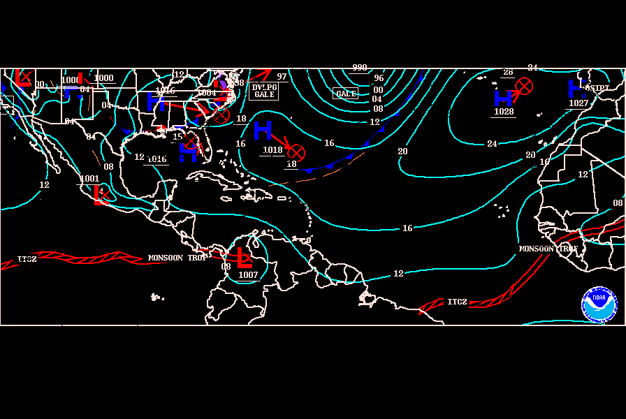
Not yet at the Surface Map at 00z. That means the wave axis is still inland.

Image
0 likes   
Visit the Caribbean-Central America Weather Thread where you can find at first post web cams,radars
and observations from Caribbean basin members Click Here

User avatar
ConvergenceZone
Category 5
Category 5
Posts: 5194
Joined: Fri Jul 29, 2005 1:40 am
Location: Northern California

#91 Postby ConvergenceZone » Sat Jul 10, 2010 10:26 pm

Is it just me or having we been seeing an abnormal amount of waves/convection rolling off Africa during the last month? I just don't recall seeing this many convective waves rolling off of Africa in July. Perhaps it's just my imagination, I don't know.....
0 likes   

User avatar
Macrocane
Category 5
Category 5
Posts: 4218
Age: 36
Joined: Sun May 24, 2009 5:35 pm
Location: El Salvador

Re: Is this for real?

#92 Postby Macrocane » Sat Jul 10, 2010 10:33 pm

IMO the number of tropical waves has been normal this season, I think that 1 wave every 3 or 4 days it's average. This one looks like a healthy wave but I don't think it's going to develop, there is no model support yet and the dry air to it's north will inhibit development in the next few days.
0 likes   

User avatar
cycloneye
Admin
Admin
Posts: 145546
Age: 68
Joined: Thu Oct 10, 2002 10:54 am
Location: San Juan, Puerto Rico

Re: Is this for real?

#93 Postby cycloneye » Sat Jul 10, 2010 10:37 pm

It has been 12 hours since I made this thread as I was interested in this system because of the plenty of convection and some spin it had at that time.12 hors later,what I see is a wave that has not poofed like many others that normally after 12 hours have almost vanished the convection. Now let's see how this system behaves in the next few hours and if I wake up to this same presentation that has excibited or it poofs eventually.
0 likes   
Visit the Caribbean-Central America Weather Thread where you can find at first post web cams,radars
and observations from Caribbean basin members Click Here

sjmballer
Tropical Low
Tropical Low
Posts: 13
Joined: Sun Sep 07, 2008 6:48 pm

#94 Postby sjmballer » Sat Jul 10, 2010 10:42 pm

I'm right with you on this one ...time will tell
0 likes   

JonathanBelles
Professional-Met
Professional-Met
Posts: 11430
Age: 35
Joined: Sat Dec 24, 2005 9:00 pm
Location: School: Florida State University (Tallahassee, FL) Home: St. Petersburg, Florida
Contact:

#95 Postby JonathanBelles » Sat Jul 10, 2010 11:11 pm

I'm looking at this wave for more of a suicide wave to clear out all of the SAL/African Dust. There is just too much dust there for development right now
0 likes   

User avatar
HURAKAN
Professional-Met
Professional-Met
Posts: 46086
Age: 38
Joined: Thu May 20, 2004 4:34 pm
Location: Key West, FL
Contact:

#96 Postby HURAKAN » Sun Jul 11, 2010 12:36 am

Nothing in the TWO. Not surprised with a wave so far east, they're waiting before saying anything. I would do the same. My 24-hour waiting period hasn't expired!!
0 likes   

User avatar
KWT
Category 5
Category 5
Posts: 31415
Joined: Tue Aug 17, 2004 11:02 am
Location: UK!!!

#97 Postby KWT » Sun Jul 11, 2010 5:18 am

Convection has really decreased recently, I don't think development is really likely at all now but thats to be expected given the large amount of stable SAL air to the north and west of the system.
0 likes   
Personal Forecast Disclaimer:
The posts in this forum are NOT official forecast and should not be used as such. They are just the opinion of the poster and may or may not be backed by sound meteorological data. They are NOT endorsed by any professional institution or storm2k.org. For official information, please refer to the NHC and NWS products

User avatar
cycloneye
Admin
Admin
Posts: 145546
Age: 68
Joined: Thu Oct 10, 2002 10:54 am
Location: San Juan, Puerto Rico

Re: Is this one for real?

#98 Postby cycloneye » Sun Jul 11, 2010 5:58 am

My impressions as I wake up this morning is, it has diminuished convection but I see some curvature in the clouds, so I wont declare it completly dead yet for some kind of development. But on the other hand, it continues to lack model support so that is a strike against it. I am starting to think this one will be out to sacrifice and then the one behind to have a better chance but I will hold on that for another 12 hours. After those 12 hours,if nothing important happens in terms of organizing,then I will give up completly and say next. :)

Image
0 likes   
Visit the Caribbean-Central America Weather Thread where you can find at first post web cams,radars
and observations from Caribbean basin members Click Here

User avatar
Blown Away
S2K Supporter
S2K Supporter
Posts: 10152
Joined: Wed May 26, 2004 6:17 am

Re: Is this one for real?

#99 Postby Blown Away » Sun Jul 11, 2010 9:24 am

Deep convection has died off as this wave moves off the coast, but there is still a big envelope of moisture along with some slight cyclonic rotation. Also, this wave is a little farther north and may have a better chance of breaking away from the ITCZ if it develops. Hasn't gone completely poof yet!
0 likes   
Hurricane Eye Experience: David 79, Irene 99, Frances 04, Jeanne 04, Wilma 05... EYE COMING MY WAY IN 2024…
Hurricane Brush Experience: Andrew 92, Erin 95, Floyd 99, Matthew 16, Irma 17, Ian 22, Nicole 22…

User avatar
KWT
Category 5
Category 5
Posts: 31415
Joined: Tue Aug 17, 2004 11:02 am
Location: UK!!!

#100 Postby KWT » Sun Jul 11, 2010 9:30 am

THis sort of wave is the type that needs to be watched down the line IMO, either in the Caribbean or in the EPAC because it has a decent bubble of moisture as BA has mentioned and doesn't look too bad at all.
0 likes   
Personal Forecast Disclaimer:
The posts in this forum are NOT official forecast and should not be used as such. They are just the opinion of the poster and may or may not be backed by sound meteorological data. They are NOT endorsed by any professional institution or storm2k.org. For official information, please refer to the NHC and NWS products


Return to “Talkin' Tropics”

Who is online

Users browsing this forum: abajan, gib, Google Adsense [Bot], LarryWx, NotSparta and 55 guests