Expert forecasts for 2014 N Atl Hurricane season

This is the general tropical discussion area. Anyone can take their shot at predicting a storms path.

Moderator: S2k Moderators

Forum rules

The posts in this forum are NOT official forecasts and should not be used as such. They are just the opinion of the poster and may or may not be backed by sound meteorological data. They are NOT endorsed by any professional institution or STORM2K. For official information, please refer to products from the National Hurricane Center and National Weather Service.

Help Support Storm2K
Message
Author
User avatar
TropicalAnalystwx13
Category 5
Category 5
Posts: 2109
Age: 27
Joined: Tue Jul 19, 2011 8:20 pm
Location: Wilmington, NC
Contact:

Re: Expert forecasts: CSU will continue to do forecasts thru Aug

#81 Postby TropicalAnalystwx13 » Mon Mar 10, 2014 11:20 pm

ninel conde wrote:
cycloneye wrote:Not a good sign for an active North Atlantic 2014 season if what the ECMWF precipitation forecast for June,July and August dry forecast for MDR/Caribbean pans out.

http://oi60.tinypic.com/1zokh1y.jpg


that goes along with the very high pressures forecasted. will be interesting if we can set 2 records this season. lowest ACE and most stable tropical atlantic ever.

Lowest ACE will be nearly impossible to beat. I doubt we'll even come close.
0 likes   

ninel conde

Re: Expert forecasts: CSU will continue to do forecasts thru Aug

#82 Postby ninel conde » Tue Mar 11, 2014 7:04 am

TropicalAnalystwx13 wrote:
ninel conde wrote:
cycloneye wrote:Not a good sign for an active North Atlantic 2014 season if what the ECMWF precipitation forecast for June,July and August dry forecast for MDR/Caribbean pans out.

http://oi60.tinypic.com/1zokh1y.jpg


that goes along with the very high pressures forecasted. will be interesting if we can set 2 records this season. lowest ACE and most stable tropical atlantic ever.

Lowest ACE will be nearly impossible to beat. I doubt we'll even come close.


we will have to see. it now seems likely the deep tropics will be flooded with bone dry air at all levels. this season might make last season seem like a monsoon in the deep tropics. i am also becoming more confident that the seemingly permanent east coast trof will once again be dominant making in close development a long shot.
0 likes   

User avatar
TropicalAnalystwx13
Category 5
Category 5
Posts: 2109
Age: 27
Joined: Tue Jul 19, 2011 8:20 pm
Location: Wilmington, NC
Contact:

Re: Expert forecasts: CSU will continue to do forecasts thru Aug

#83 Postby TropicalAnalystwx13 » Tue Mar 11, 2014 10:22 am

ninel conde wrote:we will have to see. it now seems likely the deep tropics will be flooded with bone dry air at all levels. this season might make last season seem like a monsoon in the deep tropics. i am also becoming more confident that the seemingly permanent east coast trof will once again be dominant making in close development a long shot.

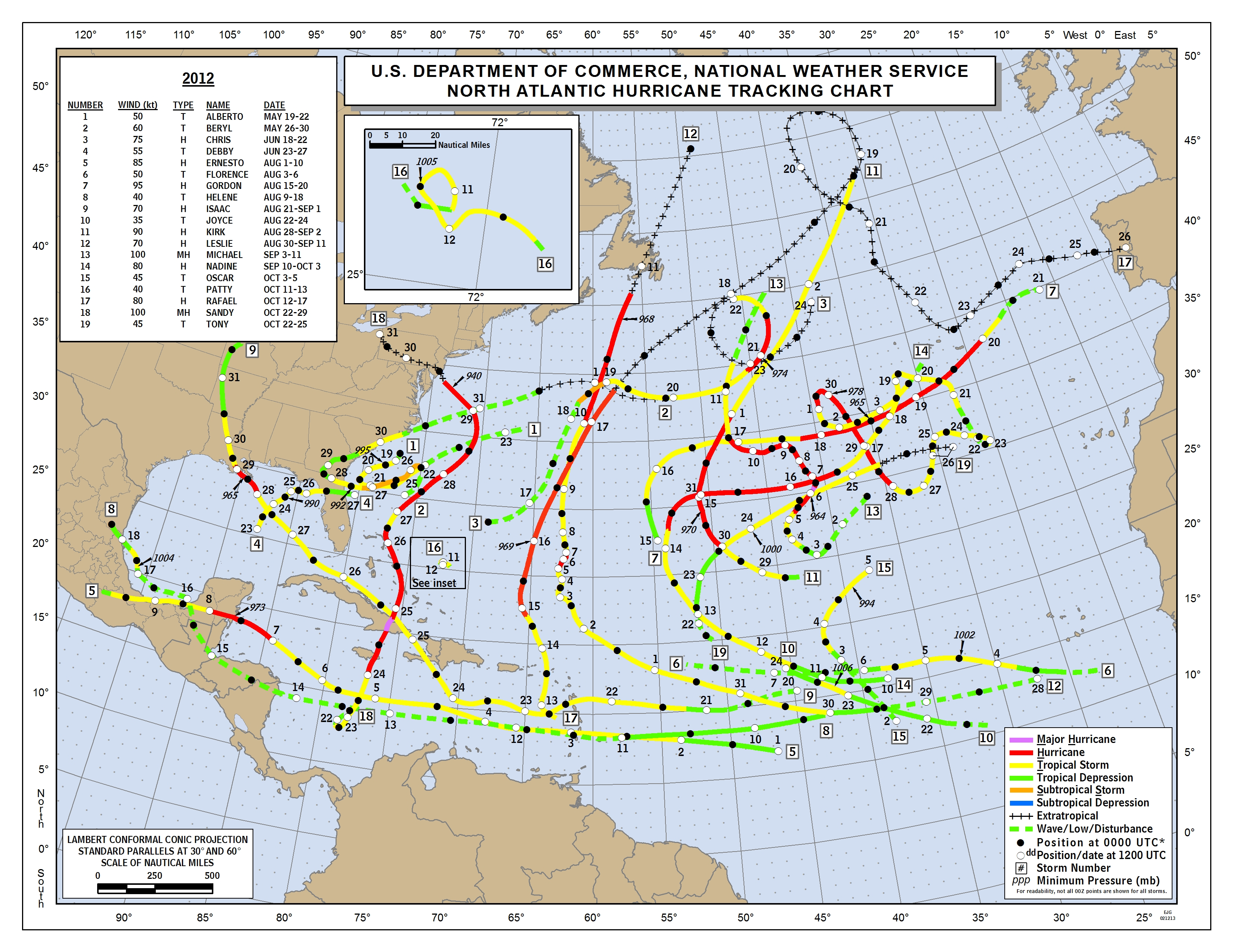
A year ago, everybody was hollering about how the 2013 Atlantic hurricane season would be above-average to hyperactive. We see how that turned out. You shouldn't be sure on anything on March 11, especially not a heights pattern that is subject to daily changes.

Image
0 likes   

User avatar
Ntxw
Storm2k Moderator
Storm2k Moderator
Posts: 22785
Joined: Wed Oct 21, 2009 6:34 pm
Location: DFW, Texas

#84 Postby Ntxw » Tue Mar 11, 2014 1:54 pm

Last year I know (csu or cpc) looked back and noted the Atlantic thermohaline as an indicator things could be quiet back then. Where can we find this data and where does such circulation stand at this point?
0 likes   
The above post and any post by Ntxw is NOT an official forecast and should not be used as such. It is just the opinion of the poster and may or may not be backed by sound meteorological data. It is NOT endorsed by any professional institution including Storm2k. For official information, please refer to NWS products.

  Help support Storm2K!
Help Support Storm2K

tolakram
Admin
Admin
Posts: 20009
Age: 62
Joined: Sun Aug 27, 2006 8:23 pm
Location: Florence, KY (name is Mark)

Re: Expert forecasts for 2014 N Atl season (See first post)

#85 Postby tolakram » Tue Mar 11, 2014 2:36 pm

I found the archives from 2013, for those interested.

http://rammb.cira.colostate.edu/projects/gparm/data/archived/2013/index.html

Replace 2013 with any year back to 2001 (as far as I've tried). There does not seem to be much correlation with March values and peak of season.

2005, for example.

http://rammb.cira.colostate.edu/projects/gparm/data/archived/2005/index.html

Just something to ponder as we wait for this season.
0 likes   
M a r k
- - - - -
Join us in chat: Storm2K Chatroom Invite. Android and IOS apps also available.

The posts in this forum are NOT official forecasts and should not be used as such. Posts are NOT endorsed by any professional institution or STORM2K.org. For official information and forecasts, please refer to NHC and NWS products.

CaliforniaResident
Tropical Storm
Tropical Storm
Posts: 212
Joined: Fri Feb 21, 2014 1:47 pm

#86 Postby CaliforniaResident » Tue Mar 11, 2014 3:51 pm

If this El Nino is Modoki (which is looking more and more likely) will it still bring above average rainfall to California?
0 likes   

WeatherGuesser
Category 5
Category 5
Posts: 2672
Joined: Tue Jun 29, 2010 6:46 am

Re: Expert forecasts: CSU will continue to do forecasts thru Aug

#87 Postby WeatherGuesser » Tue Mar 11, 2014 4:07 pm

TropicalAnalystwx13 wrote:A year ago, everybody was hollering


Two thoughts.....

You avatar is over 400K and is hotlinked directly from NOAA.

You mention the '13 season, but include a chart from '12.
0 likes   

User avatar
TropicalAnalystwx13
Category 5
Category 5
Posts: 2109
Age: 27
Joined: Tue Jul 19, 2011 8:20 pm
Location: Wilmington, NC
Contact:

Re: Expert forecasts: CSU will continue to do forecasts thru Aug

#88 Postby TropicalAnalystwx13 » Tue Mar 11, 2014 4:26 pm

WeatherGuesser wrote:
TropicalAnalystwx13 wrote:A year ago, everybody was hollering


Two thoughts.....

You avatar is over 400K and is hotlinked directly from NOAA.

You mention the '13 season, but include a chart from '12.

I guess I should've explained more--2012 is a good example of how a season can still be active without most of the activity focused in the deep tropics.
0 likes   

User avatar
TropicalAnalystwx13
Category 5
Category 5
Posts: 2109
Age: 27
Joined: Tue Jul 19, 2011 8:20 pm
Location: Wilmington, NC
Contact:

Re:

#89 Postby TropicalAnalystwx13 » Tue Mar 11, 2014 4:30 pm

Ntxw wrote:Last year I know (csu or cpc) looked back and noted the Atlantic thermohaline as an indicator things could be quiet back then. Where can we find this data and where does such circulation stand at this point?

I don't know the answer to either of these questions, but I asked Levi (TropicalTidbits) if he would be able to get a running graph for THC up on his site and he said he could as soon as his computer was fixed. In the meantime, you can view page 55 of CSU's Summary of the 2013 Atlantic hurricane season to get an idea of how THC is calculated.
0 likes   

WeatherGuesser
Category 5
Category 5
Posts: 2672
Joined: Tue Jun 29, 2010 6:46 am

Re: Expert forecasts: CSU will continue to do forecasts thru Aug

#90 Postby WeatherGuesser » Tue Mar 11, 2014 5:01 pm

WeatherGuesser wrote:You avatar is over 400K and is hotlinked directly from NOAA.

No longer Hotlinked, but still a bandwidth buster.
0 likes   

stephen23
Category 1
Category 1
Posts: 341
Joined: Sat Aug 04, 2012 10:57 pm
Location: North Fort Worth

Re: Expert forecasts for 2014 N Atl season (See first post)

#91 Postby stephen23 » Wed Mar 12, 2014 12:11 am

tolakram wrote:I found the archives from 2013, for those interested.

http://rammb.cira.colostate.edu/projects/gparm/data/archived/2013/index.html

Replace 2013 with any year back to 2001 (as far as I've tried). There does not seem to be much correlation with March values and peak of season.

2005, for example.

http://rammb.cira.colostate.edu/projects/gparm/data/archived/2005/index.html

Just something to ponder as we wait for this season.


Here is more food for thought.... I like to work statistics so put this spreadsheet together for all years from 2003-2013. Would have included 2000-2002 but the graphs don't start until May for these years so was unable to find data.

Image


Here is my thoughts..

1) over past 11 years we have been in neutral state 27% of the time, El Nino 27% of the time, and La Nina 46% of the time
2) over past 11 years 83.33% of all GOM landfall hurricanes occurred in years with Tropical Atlantic vertical Instability below average in mid March
3) Mid march Carribean vertical Instability has seemed to have no affect of landfall GOM hurricanes later that season
4)over past 11 years 66.67% of all GOM landfall hurricanes have occurred in years when GOM vertical instability was above average in mid March
5) over past 11 years 100% of years with more then one GOM landfall hurricanes have occurred in years when GOM vertical instability was above average in mid March
6) over past 11 years 100% of years have had a landfall GOM hurricane when GOM vertical instability was above average in mid March
7)over past 11 years only 28% of years have had a landfall GOM hurricane when GOM vertical instability was below average in mid March
8) March vertical instability in Sub-Tropic Atlantic has seemed to have no relationship to GOM landfall hurricanes
9)16.7% of years had GOM landfall hurricane when East Coast vertical instability was neutral during mid March
10)50% of years had GOM landfall hurricane when East Coast vertical instability was below normal in mid March
11) 33.3% of years had GOM landfall hurricane when East Coast vertical instability was above normal in mid March
12) As of March 12th.... the only year to match 2014 in mid March both positive or negative vertical instability and vertical shear in all areas (tropical Atlantic, Carribean, Gulf Of Mexico, Sub-Tropic Atlantic, and East Coast) was 2008 but 2008 was a weak La Nina year.

I know this really doesn't matter because it is only March but was fun to look up statistically.
0 likes   
Personal Forecast Disclaimer:
The posts in this forum are NOT official forecast and should not be used as such. They are just the opinion of the poster and may or may not be backed by sound meteorological data. They are NOT endorsed by any professional institution or storm2k.org. For official information, please refer to the NHC and NWS products.

stephen23
Category 1
Category 1
Posts: 341
Joined: Sat Aug 04, 2012 10:57 pm
Location: North Fort Worth

Re: Expert forecasts for 2014 N Atl season (See first post)

#92 Postby stephen23 » Wed Mar 12, 2014 11:30 am

A little bit more research I did. Since 1990......

1990,1992,1993,1994,1995,1996,2001,2003,2005,2008,2011,2012,and 2013 were all Neutral or in transition during peak hurricane season
1991,1997,2002,2004, and 2009 were all El Nino phase during peak hurricane season
1998, 1999, 2000, 2010 were all La Nina during peak hurricane season

Average of named storm in neutral years above was 15-8-3. 46% of these years had a hurricane make landfall on Gulf Coast
Average of named storms in El Nino years above was 11-5-3. 80% of these years had a hurricane make landfall on Gulf Coast
Average of named storms in La Nina years above was 15-10-4. 75% of these years had a hurricane make landfall on Gulf Coast

From what I see is with it looking like we may be headed towards El Nino by hurricane season this may bring down the total named storms for the year but appears to enhance to probability of a storm reaching Gulf Coast as Hurricane Status. Just an oppinion
0 likes   
Personal Forecast Disclaimer:
The posts in this forum are NOT official forecast and should not be used as such. They are just the opinion of the poster and may or may not be backed by sound meteorological data. They are NOT endorsed by any professional institution or storm2k.org. For official information, please refer to the NHC and NWS products.

stephen23
Category 1
Category 1
Posts: 341
Joined: Sat Aug 04, 2012 10:57 pm
Location: North Fort Worth

Re: Expert forecasts for 2014 N Atl season (See first post)

#93 Postby stephen23 » Wed Mar 12, 2014 12:22 pm

stephen23 wrote:A little bit more research I did. Since 1990......

1990,1992,1993,1994,1995,1996,2001,2003,2005,2008,2011,2012,and 2013 were all Neutral or in transition during peak hurricane season
1991,1997,2002,2004, and 2009 were all El Nino phase during peak hurricane season
1998, 1999, 2000, 2010 were all La Nina during peak hurricane season

Average of named storm in neutral years above was 15-8-3. 46% of these years had a hurricane make landfall on Gulf Coast
Average of named storms in El Nino years above was 11-5-3. 80% of these years had a hurricane make landfall on Gulf Coast
Average of named storms in La Nina years above was 15-10-4. 75% of these years had a hurricane make landfall on Gulf Coast

From what I see is with it looking like we may be headed towards El Nino by hurricane season this may bring down the total named storms for the year but appears to enhance to probability of a storm reaching Gulf Coast as Hurricane Status. Just an oppinion


A little more research and it was found that there may be a relationship between a post-Modoki el nino year and Atlantic hurricane season. Of the above listed neutral years 1992,1995,2003, 2005 were all post-Modoki years. All were very active years besides 1992. All had a GOM hurricane landfall. If you deduct post Modoki years then average named storm for a normal neutral year drops to 14-7-3 since 1990 and only 15% of normal neutral years have had a GOM hurricane landfall.
0 likes   
Personal Forecast Disclaimer:
The posts in this forum are NOT official forecast and should not be used as such. They are just the opinion of the poster and may or may not be backed by sound meteorological data. They are NOT endorsed by any professional institution or storm2k.org. For official information, please refer to the NHC and NWS products.

ninel conde

#94 Postby ninel conde » Fri Mar 14, 2014 12:25 pm

the conveyor belt of bone dry african dust is getting set up nicely.

http://moe.met.fsu.edu/cgi-bin/gfstc2.c ... hour=108hr

this looks eerily similar to last year. trof off east coast and a huge high in ne atlantic in a perfect position to sweep the bone dry african air through the deep tropics.
0 likes   

User avatar
cycloneye
Admin
Admin
Posts: 145308
Age: 68
Joined: Thu Oct 10, 2002 10:54 am
Location: San Juan, Puerto Rico

Re:

#95 Postby cycloneye » Fri Mar 14, 2014 12:33 pm

ninel conde wrote:the conveyor belt of bone dry african dust is getting set up nicely.

http://moe.met.fsu.edu/cgi-bin/gfstc2.c ... hour=108hr

this looks eerily similar to last year. trof off east coast and a huge high in ne atlantic in a perfect position to sweep the bone dry african air through the deep tropics.


Is still early in the game as many things can happen on the atmosphere in 78 days and beyond.
0 likes   
Visit the Caribbean-Central America Weather Thread where you can find at first post web cams,radars
and observations from Caribbean basin members Click Here

User avatar
wxman57
Moderator-Pro Met
Moderator-Pro Met
Posts: 22978
Age: 67
Joined: Sat Jun 21, 2003 8:06 pm
Location: Houston, TX (southwest)

Re: Expert forecasts for 2014 N Atl season (See first post)

#96 Postby wxman57 » Fri Mar 14, 2014 1:48 pm

Another negative factor is the Indian Ocean Dipole, which is forecast to go negative again this summer. This means cooler-than-normal water in the western Indian Ocean, similar to last season. This was probably a big reason why the waves coming off Africa in 2013 were so weak.
0 likes   

ninel conde

Re: Re:

#97 Postby ninel conde » Fri Mar 14, 2014 5:49 pm

cycloneye wrote:
ninel conde wrote:the conveyor belt of bone dry african dust is getting set up nicely.

http://moe.met.fsu.edu/cgi-bin/gfstc2.c ... hour=108hr

this looks eerily similar to last year. trof off east coast and a huge high in ne atlantic in a perfect position to sweep the bone dry african air through the deep tropics.


Is still early in the game as many things can happen on the atmosphere in 78 days and beyond.


true, but right now i cant see a single positive factor for this season.
0 likes   

User avatar
TropicalAnalystwx13
Category 5
Category 5
Posts: 2109
Age: 27
Joined: Tue Jul 19, 2011 8:20 pm
Location: Wilmington, NC
Contact:

Re: Expert forecasts for 2014 N Atl season (See first post)

#98 Postby TropicalAnalystwx13 » Fri Mar 14, 2014 6:54 pm

wxman57 wrote:Another negative factor is the Indian Ocean Dipole, which is forecast to go negative again this summer. This means cooler-than-normal water in the western Indian Ocean, similar to last season. This was probably a big reason why the waves coming off Africa in 2013 were so weak.

Respectfully disagreed. A neutral or negative IOD actually favors enhanced activity, as indicated by the years of 1995, 1998, 2004, 2005, 2008, and 2010. In a positive IOD, the Africa monsoon circulation is suppressed and the upper-level high over the East Atlantic is pushed farther south, focusing the southerly flow south of the MDR and replacing it with northerly flow (dry air). For this, see the seasons of 1994, 1997, 1999 (active overall, but mainly away from the MDR), 2002, 2006, and 2011.
0 likes   

User avatar
Ntxw
Storm2k Moderator
Storm2k Moderator
Posts: 22785
Joined: Wed Oct 21, 2009 6:34 pm
Location: DFW, Texas

#99 Postby Ntxw » Fri Mar 14, 2014 7:49 pm

I'm not all too familiar with how the IOD works. But I can say that convection in the Indian Ocean plays a very important role as evident in extensive research (posted several times on papers about MJO phases and TC activity as well as Hurricanes and major hurricanes). If the MJO favors the Pacific as it has been the first few months of this year then subsidence will reign supreme again in the IO, Maritime Continent, and Atlantic. Something worth keeping an eye on.
0 likes   
The above post and any post by Ntxw is NOT an official forecast and should not be used as such. It is just the opinion of the poster and may or may not be backed by sound meteorological data. It is NOT endorsed by any professional institution including Storm2k. For official information, please refer to NWS products.


  Help support Storm2K!

Help Support Storm2K


Alyono
Professional-Met
Professional-Met
Posts: 6961
Joined: Fri Apr 26, 2013 3:52 pm
Location: Texas Coast

#100 Postby Alyono » Sat Mar 15, 2014 6:46 am

might not want to include 1999 as an inactive MDR year. It was extremely active within the MDR. Most things that year formed south of 20N and were quite intense
0 likes   


Return to “Talkin' Tropics”

Who is online

Users browsing this forum: abajan, Google [Bot], NotSparta, riapal, Sciencerocks, StormWeather, TomballEd and 49 guests