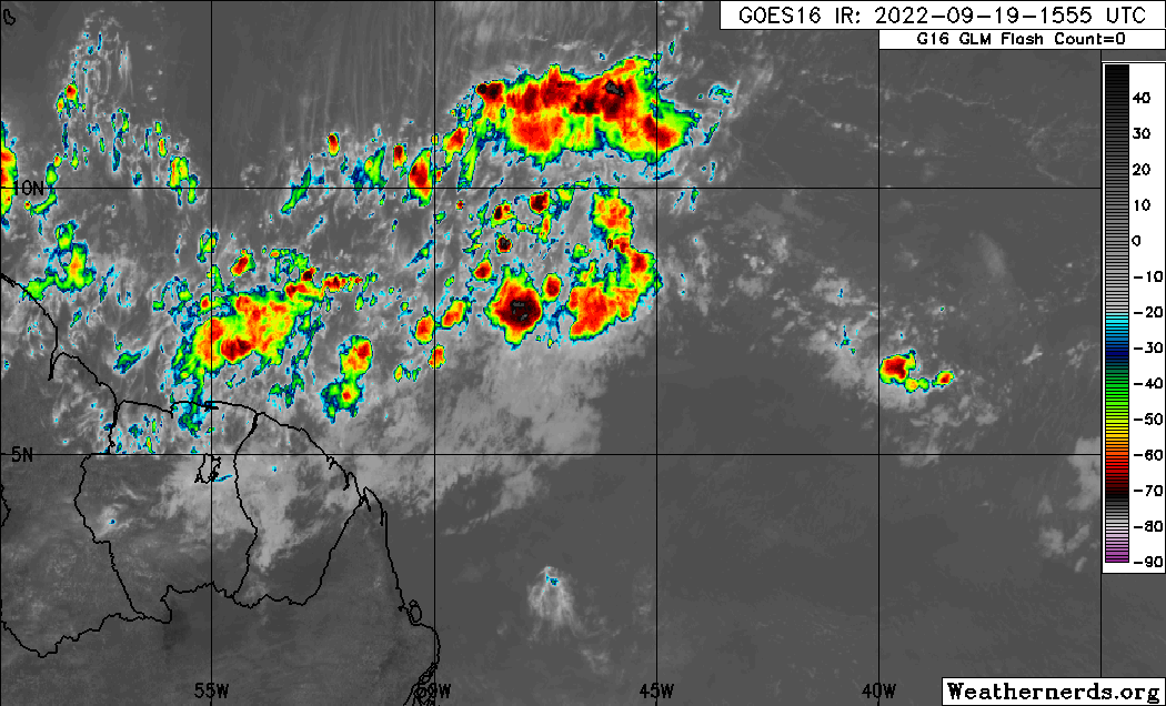
Tropical wave east of the Windward Islands (Is Invest 98L)
Moderator: S2k Moderators
Forum rules

The posts in this forum are NOT official forecasts and should not be used as such. They are just the opinion of the poster and may or may not be backed by sound meteorological data. They are NOT endorsed by any professional institution or STORM2K. For official information, please refer to products from the National Hurricane Center and National Weather Service.
-
tolakram
- Admin

- Posts: 20186
- Age: 62
- Joined: Sun Aug 27, 2006 8:23 pm
- Location: Florence, KY (name is Mark)
Re: Tropical wave near 47W
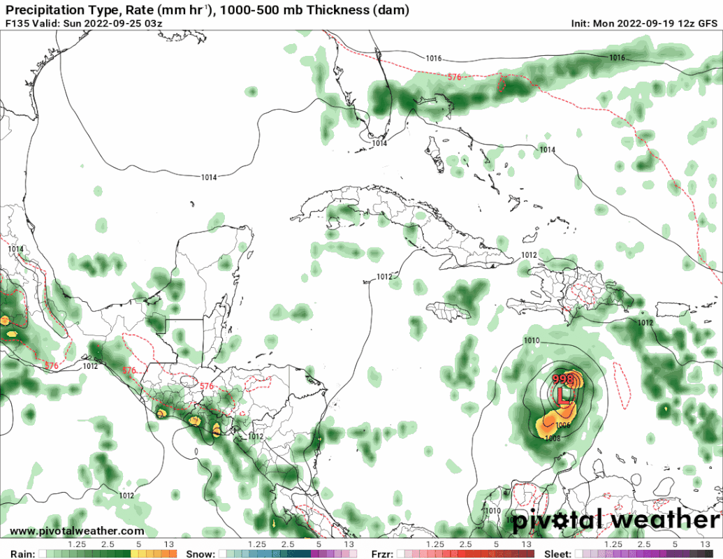
That is suspect IMO. The GFS magically spins up a storm from an unfocused area of vorticity. Might be the typical GFS phantom.

0 likes
M a r k
- - - - -
Join us in chat: Storm2K Chatroom Invite. Android and IOS apps also available.
The posts in this forum are NOT official forecasts and should not be used as such. Posts are NOT endorsed by any professional institution or STORM2K.org. For official information and forecasts, please refer to NHC and NWS products.
-
SFLcane

- S2K Supporter

- Posts: 10281
- Age: 48
- Joined: Sat Jun 05, 2010 1:44 pm
- Location: Lake Worth Florida
Re: Tropical wave near 47W
tolakram wrote:That is suspect IMO. The GFS magically spins up a storm from an unfocused area of vorticity. Might be the typical GFS phantom.
https://i.imgur.com/QcOKgSH.gif
This is not suspect its clearly from the wave at 50w.
6 likes
-
PTrackerLA

- Category 5

- Posts: 5281
- Age: 42
- Joined: Thu Oct 10, 2002 8:40 pm
- Location: Lafayette, LA
Re: Tropical wave near 47W
Lemon coming up this afternoon for sure  . I think the GFS is way too quick with development but the fact this shows up in all the other models gives me cause for concern.
0 likes
-
AutoPenalti
- Category 5
- Posts: 4091
- Age: 29
- Joined: Mon Aug 17, 2015 4:16 pm
- Location: Ft. Lauderdale, Florida
Re: Tropical wave near 47W
tolakram wrote:That is suspect IMO. The GFS magically spins up a storm from an unfocused area of vorticity. Might be the typical GFS phantom.
https://i.imgur.com/QcOKgSH.gif
It's the wave east of the Antilles
1 likes
The posts in this forum are NOT official forecasts and should not be used as such. They are just the opinion of the poster and may or may not be backed by sound meteorological data. They are NOT endorsed by any professional institution or STORM2K. For official information, please refer to products from the NHC and NWS.
Model Runs Cheat Sheet:
GFS (5:30 AM/PM, 11:30 AM/PM)
HWRF, GFDL, UKMET, NAVGEM (6:30-8:00 AM/PM, 12:30-2:00 AM/PM)
ECMWF (1:45 AM/PM)
TCVN is a weighted averaged
-
tolakram
- Admin
- Posts: 20186
- Age: 62
- Joined: Sun Aug 27, 2006 8:23 pm
- Location: Florence, KY (name is Mark)
Re: Tropical wave near 47W
SFLcane wrote:tolakram wrote:That is suspect IMO. The GFS magically spins up a storm from an unfocused area of vorticity. Might be the typical GFS phantom.
https://i.imgur.com/QcOKgSH.gif
This is not suspect its clearly from the wave at 50w.
Yep. clearly from a wave, not what I meant by unfocussed. So higher chance that a random gyre spinup perhaps, but still might be a phantom.
0 likes
M a r k
- - - - -
Join us in chat: Storm2K Chatroom Invite. Android and IOS apps also available.
The posts in this forum are NOT official forecasts and should not be used as such. Posts are NOT endorsed by any professional institution or STORM2K.org. For official information and forecasts, please refer to NHC and NWS products.
- - - - -
Join us in chat: Storm2K Chatroom Invite. Android and IOS apps also available.
The posts in this forum are NOT official forecasts and should not be used as such. Posts are NOT endorsed by any professional institution or STORM2K.org. For official information and forecasts, please refer to NHC and NWS products.
-
PTrackerLA
- Category 5
- Posts: 5281
- Age: 42
- Joined: Thu Oct 10, 2002 8:40 pm
- Location: Lafayette, LA

-
PTrackerLA
- Category 5
- Posts: 5281
- Age: 42
- Joined: Thu Oct 10, 2002 8:40 pm
- Location: Lafayette, LA
Re: Tropical wave near 47W
SFLcane wrote:GFS has this one pegged in my opinion.
Makes me think back to 2020 and how the models seemed to miss everything. I would not discount the GFS at this time at all.
0 likes
-
skyline385

- Category 5
- Posts: 2728
- Age: 35
- Joined: Wed Aug 26, 2020 11:15 pm
- Location: Houston TX
Re: Tropical wave near 47W
It’s also in the CMC but gets slammed into SA. Regardless very likely we get a lemon soon if this trend continues, probably even today. ICON was already on board in the 0Z and 6Z runs and it even popped up on the 06Z Euro.

Sent from my iPhone using Tapatalk
Sent from my iPhone using Tapatalk
0 likes
-
tolakram
- Admin
- Posts: 20186
- Age: 62
- Joined: Sun Aug 27, 2006 8:23 pm
- Location: Florence, KY (name is Mark)
Re: Tropical wave near 47W
Visible: https://www.star.nesdis.noaa.gov/GOES/sector_band.php?sat=G16§or=taw&band=02&length=12
SLIDER closeup: https://rammb-slider.cira.colostate.edu/?sat=goes-16&sec=full_disk&x=16202&y=8982&z=4&angle=0&im=12&ts=1&st=0&et=0&speed=130&motion=loop&maps%5Bborders%5D=white&lat=0&p%5B0%5D=cira_proxy_visible&opacity%5B0%5D=1&pause=0&slider=-1&hide_controls=0&mouse_draw=0&follow_feature=0&follow_hide=0&s=rammb-slider&draw_color=FFD700&draw_width=6
SLIDER closeup: https://rammb-slider.cira.colostate.edu/?sat=goes-16&sec=full_disk&x=16202&y=8982&z=4&angle=0&im=12&ts=1&st=0&et=0&speed=130&motion=loop&maps%5Bborders%5D=white&lat=0&p%5B0%5D=cira_proxy_visible&opacity%5B0%5D=1&pause=0&slider=-1&hide_controls=0&mouse_draw=0&follow_feature=0&follow_hide=0&s=rammb-slider&draw_color=FFD700&draw_width=6
0 likes
M a r k
- - - - -
Join us in chat: Storm2K Chatroom Invite. Android and IOS apps also available.
The posts in this forum are NOT official forecasts and should not be used as such. Posts are NOT endorsed by any professional institution or STORM2K.org. For official information and forecasts, please refer to NHC and NWS products.
- - - - -
Join us in chat: Storm2K Chatroom Invite. Android and IOS apps also available.
The posts in this forum are NOT official forecasts and should not be used as such. Posts are NOT endorsed by any professional institution or STORM2K.org. For official information and forecasts, please refer to NHC and NWS products.
-
Iceresistance

- Category 5
- Posts: 9606
- Age: 22
- Joined: Sat Oct 10, 2020 9:45 am
- Location: Tecumseh, OK/Norman, OK
Re: Tropical wave near 47W
PTrackerLA wrote:SFLcane wrote:GFS has this one pegged in my opinion.
Makes me think back to 2020 and how the models seemed to miss everything. I would not discount the GFS at this time at all.
We may have another sleeper wave, the models were not picking it up very well until recently.
0 likes
Bill 2015 & Beta 2020
Winter 2020-2021
All observations are in Tecumseh, OK unless otherwise noted.
Winter posts are focused mainly for Oklahoma & Texas.
Take any of my forecasts with a grain of salt, refer to the NWS, SPC, and NHC for official information
Never say Never with weather! Because ANYTHING is possible!
Winter 2020-2021
All observations are in Tecumseh, OK unless otherwise noted.
Winter posts are focused mainly for Oklahoma & Texas.
Take any of my forecasts with a grain of salt, refer to the NWS, SPC, and NHC for official information
Never say Never with weather! Because ANYTHING is possible!

Re: Tropical wave near 47W
Assuming this spins up, the Caribbean at large looks to have very minimal shear. Pretty vintage La Nina look.
3 likes


-
Blown Away

- S2K Supporter
- Posts: 10253
- Joined: Wed May 26, 2004 6:17 am
Re: Tropical wave near 47W
GFS says there could be a hurricane in the Caribbean in five days, I think a yellow lemon is warranted at 2 PM.
2 likes
Hurricane Eye Experience: David 79, Irene 99, Frances 04, Jeanne 04, Wilma 05… Hurricane Brush Experience: Andrew 92, Erin 95, Floyd 99, Matthew 16, Irma 17, Ian 22, Nicole 22…
-
Iceresistance
- Category 5
- Posts: 9606
- Age: 22
- Joined: Sat Oct 10, 2020 9:45 am
- Location: Tecumseh, OK/Norman, OK
Re: Tropical wave near 47W
The GFS is maintaining the intensity of this system as a strong TS (Mid-990s mb) before it reaches the Western Caribbean, I'm really not liking this trend.
1 likes
Bill 2015 & Beta 2020
Winter 2020-2021
All observations are in Tecumseh, OK unless otherwise noted.
Winter posts are focused mainly for Oklahoma & Texas.
Take any of my forecasts with a grain of salt, refer to the NWS, SPC, and NHC for official information
Never say Never with weather! Because ANYTHING is possible!
Winter 2020-2021
All observations are in Tecumseh, OK unless otherwise noted.
Winter posts are focused mainly for Oklahoma & Texas.
Take any of my forecasts with a grain of salt, refer to the NWS, SPC, and NHC for official information
Never say Never with weather! Because ANYTHING is possible!
-
AutoPenalti
- Category 5
- Posts: 4091
- Age: 29
- Joined: Mon Aug 17, 2015 4:16 pm
- Location: Ft. Lauderdale, Florida
Re: Tropical wave near 47W
Here comes the curve.
0 likes
The posts in this forum are NOT official forecasts and should not be used as such. They are just the opinion of the poster and may or may not be backed by sound meteorological data. They are NOT endorsed by any professional institution or STORM2K. For official information, please refer to products from the NHC and NWS.
Model Runs Cheat Sheet:
GFS (5:30 AM/PM, 11:30 AM/PM)
HWRF, GFDL, UKMET, NAVGEM (6:30-8:00 AM/PM, 12:30-2:00 AM/PM)
ECMWF (1:45 AM/PM)
TCVN is a weighted averaged
Who is online
Users browsing this forum: No registered users and 221 guests