
Low Pressure in the Northwest Caribbean Sea (Is Invest 93L)
Moderator: S2k Moderators
Forum rules

The posts in this forum are NOT official forecasts and should not be used as such. They are just the opinion of the poster and may or may not be backed by sound meteorological data. They are NOT endorsed by any professional institution or STORM2K. For official information, please refer to products from the National Hurricane Center and National Weather Service.
-
HurricaneBelle

- S2K Supporter

- Posts: 1209
- Joined: Sun Aug 27, 2006 6:12 pm
- Location: Clearwater, FL
Re: Possible Development in the Northwestern Caribbean
Not the kind of orange I wanted with breakfast
10 likes

Re: Possible Development in the Northwestern Caribbean
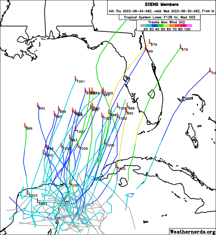
Ianswfl wrote:SFLcane wrote:USTropics wrote:A bit more active on the 06z GFS ensembles compared to 00z:
https://i.imgur.com/v4JDJby.gif
Weak still. 00z euro ensembles more tame too, not those cat4s earlier runs had. Icon 6z came in weaker too. Could see a cat1 i think.if it's gfs path into tampa or sarasota like these ensembles members could be some nice rains. Swfl members would still be a problem with recovery efforts.
Way too early to know for sure the strength of it once it comes out of NW Caribbean but one thing for sure is that now the Euro ensembles are not as spread out over the GOM as earlier runs, more agreement on a development and possible heading.

0 likes

Re: Possible Development in the Northwestern Caribbean
CAPE around 2000 to 3000 currently in the east GoM.
Around Tuesday, it looks like it will be about 4000 to 5000.
However, a ULL is forecast by GFS to be in the east GoM then.
Likely, this is why GFS currently doesn't do much with it.
Euro on the other hand has the ULL much further west in the GoM.
Looks far enough away to enhance outflow.
Something to watch how the models trend.
5 likes
-
Iceresistance

- Category 5

- Posts: 9606
- Age: 22
- Joined: Sat Oct 10, 2020 9:45 am
- Location: Tecumseh, OK/Norman, OK
Re: Possible Development in the Northwestern Caribbean
Okay, I will admit that this was actually funny.
0 likes
Bill 2015 & Beta 2020
Winter 2020-2021
All observations are in Tecumseh, OK unless otherwise noted.
Winter posts are focused mainly for Oklahoma & Texas.
Take any of my forecasts with a grain of salt, refer to the NWS, SPC, and NHC for official information
Never say Never with weather! Because ANYTHING is possible!
Winter 2020-2021
All observations are in Tecumseh, OK unless otherwise noted.
Winter posts are focused mainly for Oklahoma & Texas.
Take any of my forecasts with a grain of salt, refer to the NWS, SPC, and NHC for official information
Never say Never with weather! Because ANYTHING is possible!

Re: Possible Development in the Northwestern Caribbean
surprised they haven't classified it as an invest yet
3 likes
Just like Jon Snow..."I know nothing" except what I know, and most of what I know is gathered by the fine people of the NHC
Re: Possible Development in the Northwestern Caribbean
The ULL is strengthening and moving from the Yucatan into the BoC
1 likes
-
AutoPenalti
- Category 5
- Posts: 4091
- Age: 29
- Joined: Mon Aug 17, 2015 4:16 pm
- Location: Ft. Lauderdale, Florida
Re: Possible Development in the Northwestern Caribbean
GCANE wrote:The ULL is strengthening and moving from the Yucatan into the BoC
A chance that the GFS may verify?
0 likes
The posts in this forum are NOT official forecasts and should not be used as such. They are just the opinion of the poster and may or may not be backed by sound meteorological data. They are NOT endorsed by any professional institution or STORM2K. For official information, please refer to products from the NHC and NWS.
Model Runs Cheat Sheet:
GFS (5:30 AM/PM, 11:30 AM/PM)
HWRF, GFDL, UKMET, NAVGEM (6:30-8:00 AM/PM, 12:30-2:00 AM/PM)
ECMWF (1:45 AM/PM)
TCVN is a weighted averaged
Re: Possible Development in the Northwestern Caribbean
AutoPenalti wrote:GCANE wrote:The ULL is strengthening and moving from the Yucatan into the BoC
A chance that the GFS may verify?
Watching carefully how it trends next few runs
0 likes
-
wxman57

- Moderator-Pro Met

- Posts: 23175
- Age: 68
- Joined: Sat Jun 21, 2003 8:06 pm
- Location: Houston, TX (southwest)
Re: Possible Development in the Northwestern Caribbean
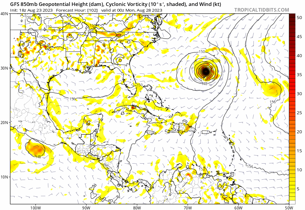
There is no disturbance in the Caribbean now. The feature the Euro develops has just moved north out of the East Pacific into western Nicaragua. There can't be any circulation developing in the Caribbean, as that guy tweeted a few posts up. Look at the 850mb vorticity in the EC and you'll see it tracking north across western Nicaragua today, across Honduras tonight, and lying east of Belize Friday morning. It's near Cancun/Cozumel by sunrise Saturday, where it stalls for a day or two while it organizes.
4 likes

Re: Possible Development in the Northwestern Caribbean
SFLcane wrote:https://i.postimg.cc/KYNYwvB1/gggg.png
Looks like the 06z ensembles shifted east a tad. Imo landfall around Pasco county. Entire west coast in the dirtt side
0 likes
-
SFLcane

- S2K Supporter
- Posts: 10281
- Age: 48
- Joined: Sat Jun 05, 2010 1:44 pm
- Location: Lake Worth Florida
Re: Possible Development in the Northwestern Caribbean
wxman57 wrote:There is no disturbance in the Caribbean now. The feature the Euro develops has just moved north out of the East Pacific into western Nicaragua. There can't be any circulation developing in the Caribbean, as that guy tweeted a few posts up. Look at the 850mb vorticity in the EC and you'll see it tracking north across western Nicaragua today, across Honduras tonight, and lying east of Belize Friday morning. It's near Cancun/Cozumel by sunrise Saturday, where it stalls for a day or two while it organizes.
Makes sense! Thanks
0 likes

Re: Possible Development in the Northwestern Caribbean
Good shear gradient over Honduras.
Should see some strong thunderstorms popup this afternoon and likely push out into the water.
Should see some strong thunderstorms popup this afternoon and likely push out into the water.
0 likes
-
cycloneye

- Admin

- Posts: 149703
- Age: 69
- Joined: Thu Oct 10, 2002 10:54 am
- Location: San Juan, Puerto Rico
Re: Possible Development in the Northwestern Caribbean
CronkPSU wrote:surprised they haven't classified it as an invest yet
Two things about this. #1, is still in the EPAC side, and #2, it only has 10% in 2 days. Normally, is between 20% and 40% the window to have a invest up.
3 likes
Visit the Caribbean-Central America Weather Thread where you can find at first post web cams,radars
and observations from Caribbean basin members Click Here
and observations from Caribbean basin members Click Here
-
Hurricaneman

- Category 5
- Posts: 7404
- Age: 45
- Joined: Tue Aug 31, 2004 3:24 pm
- Location: central florida
Re: Possible Development in the Northwestern Caribbean
This seems to be moving into Nicaragua and will be in Honduras this afternoon sometime
0 likes
-
zal0phus

- Tropical Storm

- Posts: 201
- Age: 25
- Joined: Mon Jan 07, 2019 8:32 am
- Location: St. Louis
- Contact:
Re: Possible Development in the Northwestern Caribbean
If this gets named I hope it gets Jose instead of Idalia. I've gotten very sick of Gulf storms with I names these past few years.
1 likes
Do not take anything I say seriously as a form of meteorological prediction. I am not a meteorologist; I don't think being in law school translates to any special knowledge. I am just a somewhat bullish amateur watcher.
-
Category5Kaiju

- Category 5
- Posts: 4345
- Joined: Thu Dec 24, 2020 12:45 pm
- Location: Seattle during the summer, Phoenix during the winter
Re: Possible Development in the Northwestern Caribbean
zal0phus wrote:If this gets named I hope it gets Jose instead of Idalia. I've gotten very sick of Gulf storms with I names these past few years.
Technically it would be Jose, but no we just had to have an unnamed storm in early January
2 likes
Unless explicitly stated, all information in my posts is based on my own opinions and observations. Tropical storms and hurricanes can be extremely dangerous. Refer to an accredited weather research agency or meteorologist if you need to make serious decisions regarding an approaching storm.
-
Kingarabian

- S2K Supporter
- Posts: 16378
- Joined: Sat Aug 08, 2009 3:06 am
- Location: Honolulu, Hawaii
Re: Possible Development in the Northwestern Caribbean
12z GFS showing some sort of 850mb vort now.
Trend
Trend
0 likes
RIP Kobe Bryant
Who is online
Users browsing this forum: Iceresistance, Ulf, WaveBreaking and 230 guests