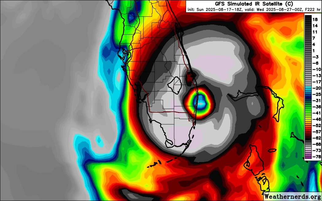
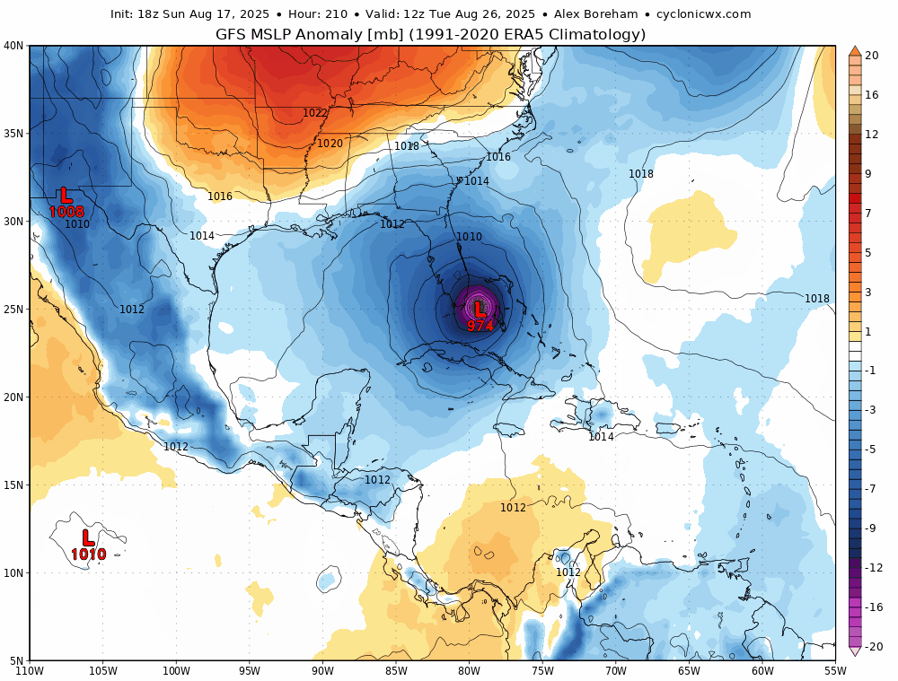
Tropical Wave in the Central Atlantic (10/60)

This is the general tropical discussion area. Anyone can take their shot at predicting a storms path.

Moderator: S2k Moderators

Forum rules

The posts in this forum are NOT official forecasts and should not be used as such. They are just the opinion of the poster and may or may not be backed by sound meteorological data. They are NOT endorsed by any professional institution or STORM2K. For official information, please refer to products from the National Hurricane Center and National Weather Service.

Help Support Storm2K
Message
Author
AxaltaRacing24
Category 5
Category 5
Posts: 1766
Age: 25
Joined: Wed Jul 27, 2016 11:14 am
Location: Jupiter, FL

Re: Tropical Wave Near the Cabo Verde Islands (0/40)

#81 Postby AxaltaRacing24 » Sun Aug 17, 2025 9:31 pm

ROCK wrote:
eastcoastFL wrote:
Stormcenter wrote:I know this is still a long ways out but I think it has GOM storm written all over it. IMO


Why?


I agree. Sniffs that way to me also. Eject Erin and builds the high. Weak wave into the Caribbean or disrupted by the islands. Stay more west. Trof doesn’t dig as they typically DONT do in August. Yeah I can see it. NO to WC FL smelling that way to me. ICON is the new Euro from years past..IMO. :lol:

and yeah i don't know what has happened to the Euro, but it plays catch-up a lot now. the ICON recently reminds me of the Euro of old more than the Euro itself.
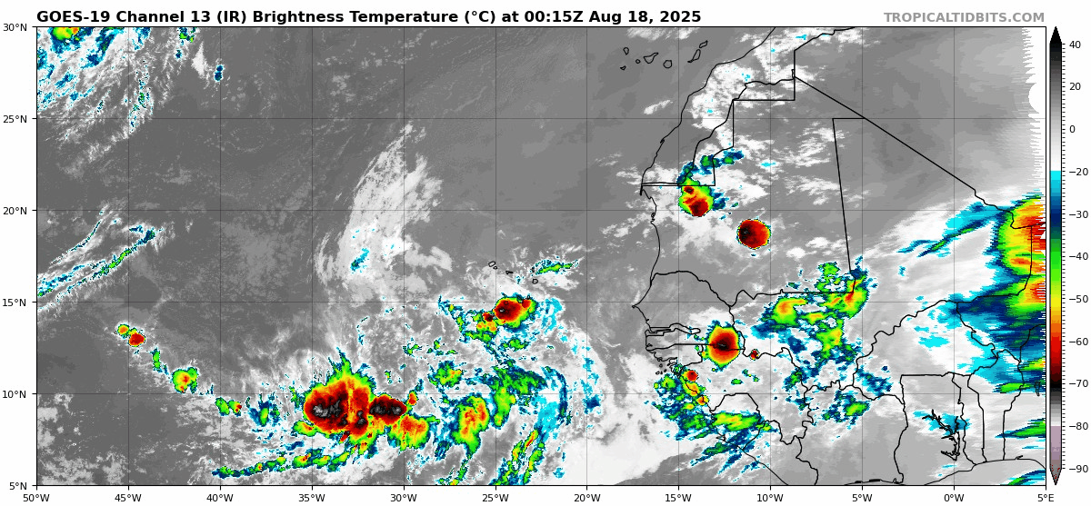
0 likes   

User avatar
Hurrilurker
Category 2
Category 2
Posts: 728
Joined: Mon Jun 09, 2003 3:32 pm
Location: San Francisco, CA

Re: Tropical Wave Near the Cabo Verde Islands (0/40)

#82 Postby Hurrilurker » Sun Aug 17, 2025 9:41 pm

According to NHC's projected cone, it looks like it's at least 75% likely to pass through Hebert Box 1. No one in the SE CONUS or Caribbean should take their eye off this one.
2 likes   

EgmontBeachBum
Tropical Wave
Tropical Wave
Posts: 1
Joined: Sat Aug 09, 2025 7:09 am

Re: Tropical Wave Near the Cabo Verde Islands (0/40)

#83 Postby EgmontBeachBum » Sun Aug 17, 2025 9:44 pm

Tonight's euro shows the escape route closing ever so slightly. Wonder if that starts the trend towards a Gulf storm?
2 likes   

skillz305
Category 1
Category 1
Posts: 287
Joined: Sat Sep 08, 2018 11:10 am
Location: Miami, Florida --> Vero Beach, Florida

Re: Tropical Wave Near the Cabo Verde Islands (0/40)

#84 Postby skillz305 » Sun Aug 17, 2025 9:45 pm

18z GFS, I don’t like it one bit …
0 likes   
:flag:Hurricanes: Andrew 1992 - Irene 1999 - Frances 2004 - Jeanne 2004 - Katrina 2005 - Wilma 2005 - Matthew 2016 - Irma 2017 - Ian 2022 - Nicole 2022 - Milton 2024

User avatar
wzrgirl1
S2K Supporter
S2K Supporter
Posts: 1331
Joined: Sat Sep 04, 2004 6:44 am
Location: Pembroke Pines, Florida

Re: Tropical Wave Near the Cabo Verde Islands (0/40)

#85 Postby wzrgirl1 » Sun Aug 17, 2025 9:56 pm

skillz305 wrote:18z GFS, I don’t like it one bit …


Share please
0 likes   

User avatar
SFLcane
S2K Supporter
S2K Supporter
Posts: 10179
Age: 47
Joined: Sat Jun 05, 2010 1:44 pm
Location: Lake Worth Florida

Re: Tropical Wave Near the Cabo Verde Islands (0/40)

#86 Postby SFLcane » Sun Aug 17, 2025 10:03 pm

Hi guys, Not much yet but look at the spin already in the area. :eek:

I for one watching this one pretty close since this will not be another erin spinning up near 18n close to africa. No development for a few days so it could very well sneak into the caribbean eventually there could be a turn north over cuba, florida, gulf lots of outcomes but by then they all impact some landmass.

Image
3 likes   

User avatar
SFLcane
S2K Supporter
S2K Supporter
Posts: 10179
Age: 47
Joined: Sat Jun 05, 2010 1:44 pm
Location: Lake Worth Florida

Re: Tropical Wave Near the Cabo Verde Islands (0/40)

#87 Postby SFLcane » Sun Aug 17, 2025 10:06 pm

wzrgirl1 wrote:
skillz305 wrote:18z GFS, I don’t like it one bit …


Share please


Image
4 likes   

skillz305
Category 1
Category 1
Posts: 287
Joined: Sat Sep 08, 2018 11:10 am
Location: Miami, Florida --> Vero Beach, Florida

Re: Tropical Wave Near the Cabo Verde Islands (0/40)

#88 Postby skillz305 » Sun Aug 17, 2025 10:06 pm

wzrgirl1 wrote:
skillz305 wrote:18z GFS, I don’t like it one bit …


Share please


https://www.tropicaltidbits.com/analysis/models/

GFS 18z should be the first that pops up on page
1 likes   
:flag:Hurricanes: Andrew 1992 - Irene 1999 - Frances 2004 - Jeanne 2004 - Katrina 2005 - Wilma 2005 - Matthew 2016 - Irma 2017 - Ian 2022 - Nicole 2022 - Milton 2024

LarryWx
S2K Supporter
S2K Supporter
Posts: 6465
Joined: Sun Sep 07, 2003 2:04 pm
Location: GA

Re: Tropical Wave Near the Cabo Verde Islands (0/40)

#89 Postby LarryWx » Sun Aug 17, 2025 10:07 pm

Any opinion about what an earlier than modeled TCG, should it occur, would mean regarding the chances of it recurving like the Euro, UKMET, and CMC are showing?
0 likes   
Personal Forecast Disclaimer:
The posts in this forum are NOT official forecasts and should not be used as such. They are just the opinion of the poster and may or may not be backed by sound meteorological data. They are NOT endorsed by any professional institution or storm2k.org. For official information, please refer to the NHC and NWS products.

User avatar
SFLcane
S2K Supporter
S2K Supporter
Posts: 10179
Age: 47
Joined: Sat Jun 05, 2010 1:44 pm
Location: Lake Worth Florida

Re: Tropical Wave Near the Cabo Verde Islands (0/40)

#90 Postby SFLcane » Sun Aug 17, 2025 10:09 pm

LarryWx wrote:Any opinion about what an earlier than modeled TCG, should it occur, would mean regarding the chances of it recurving like the Euro, UKMET, and CMC are showing?


Hi larry, for now no model shows this doing much of anything for a few days and that is tad worrisome in my opinion. I think if this develops earlier it would very much find a quick exit but that is not the current NHC thinking for now.
1 likes   

User avatar
wzrgirl1
S2K Supporter
S2K Supporter
Posts: 1331
Joined: Sat Sep 04, 2004 6:44 am
Location: Pembroke Pines, Florida

Re: Tropical Wave Near the Cabo Verde Islands (0/40)

#91 Postby wzrgirl1 » Sun Aug 17, 2025 10:11 pm

skillz305 wrote:
wzrgirl1 wrote:
skillz305 wrote:18z GFS, I don’t like it one bit …


Share please


https://www.tropicaltidbits.com/analysis/models/

GFS 18z should be the first that pops up on page


Sorry I asked :eek:
4 likes   

skillz305
Category 1
Category 1
Posts: 287
Joined: Sat Sep 08, 2018 11:10 am
Location: Miami, Florida --> Vero Beach, Florida

Re: Tropical Wave Near the Cabo Verde Islands (0/40)

#92 Postby skillz305 » Sun Aug 17, 2025 10:49 pm

00z GFS starting to run
0 likes   
:flag:Hurricanes: Andrew 1992 - Irene 1999 - Frances 2004 - Jeanne 2004 - Katrina 2005 - Wilma 2005 - Matthew 2016 - Irma 2017 - Ian 2022 - Nicole 2022 - Milton 2024

Pelicane
Tropical Storm
Tropical Storm
Posts: 120
Joined: Tue Sep 13, 2022 1:52 pm
Location: Lafayette, Louisiana

Re: Tropical Wave Near the Cabo Verde Islands (0/40)

#93 Postby Pelicane » Sun Aug 17, 2025 10:50 pm

ICON shears it to death
0 likes   

LarryWx
S2K Supporter
S2K Supporter
Posts: 6465
Joined: Sun Sep 07, 2003 2:04 pm
Location: GA

Re: Tropical Wave Near the Cabo Verde Islands (0/40)

#94 Postby LarryWx » Sun Aug 17, 2025 11:15 pm

0Z UKMET: weaker and delayed TCG that is already moving NE at TCG and headed to E of Bermuda: possible reason is that Erin recurves the furthest W yet at 74.8W and with it moving out much more slowly again

NEW TROPICAL CYCLONE FORECAST TO DEVELOP AFTER 162 HOURS
FORECAST POSITION AT T+162 : 28.9N 63.5W

LEAD CENTRAL MAXIMUM WIND
VERIFYING TIME TIME POSITION PRESSURE (MB) SPEED (KNOTS)
-------------- ---- -------- ------------- -------------
0000UTC 25.08.2025 168 30.5N 62.1W 1013 31
0 likes   
Personal Forecast Disclaimer:
The posts in this forum are NOT official forecasts and should not be used as such. They are just the opinion of the poster and may or may not be backed by sound meteorological data. They are NOT endorsed by any professional institution or storm2k.org. For official information, please refer to the NHC and NWS products.

Pelicane
Tropical Storm
Tropical Storm
Posts: 120
Joined: Tue Sep 13, 2022 1:52 pm
Location: Lafayette, Louisiana

Re: Tropical Wave Near the Cabo Verde Islands (0/40)

#95 Postby Pelicane » Sun Aug 17, 2025 11:20 pm

Anytime you have a mis-aligned vortex and the skirting of landmasses, you're bound to get some funky business with center relocations.

Assuming it does not go OTS, that and how it interacts with the ULL ahead of it will determine any threat to CONUS. Hard to really predict that even within a days time frame.
2 likes   

Stratton23
Category 5
Category 5
Posts: 2631
Joined: Fri Jul 21, 2023 10:59 pm
Location: Katy, Tx

Re: Tropical Wave Near the Cabo Verde Islands (0/40)

#96 Postby Stratton23 » Sun Aug 17, 2025 11:38 pm

00z GFS trending west, back into the gulf again, looks like landfall around the florida panhandle, trending towards a weaker east coast trough and stronger ridging building in
3 likes   

skillz305
Category 1
Category 1
Posts: 287
Joined: Sat Sep 08, 2018 11:10 am
Location: Miami, Florida --> Vero Beach, Florida

Re: Tropical Wave Near the Cabo Verde Islands (0/40)

#97 Postby skillz305 » Sun Aug 17, 2025 11:45 pm

Stratton23 wrote:00z GFS trending west, back into the gulf again, looks like landfall around the florida panhandle, trending towards a weaker east coast trough and stronger ridging building in


Sorry to correct, but that’s thru the keys and up the west coast into Ocala and out by Jacksonville, not the panhandle.
1 likes   
:flag:Hurricanes: Andrew 1992 - Irene 1999 - Frances 2004 - Jeanne 2004 - Katrina 2005 - Wilma 2005 - Matthew 2016 - Irma 2017 - Ian 2022 - Nicole 2022 - Milton 2024

User avatar
SFLcane
S2K Supporter
S2K Supporter
Posts: 10179
Age: 47
Joined: Sat Jun 05, 2010 1:44 pm
Location: Lake Worth Florida

Re: Tropical Wave Near the Cabo Verde Islands (0/40)

#98 Postby SFLcane » Sun Aug 17, 2025 11:45 pm

Stratton23 wrote:00z GFS trending west, back into the gulf again, looks like landfall around the florida panhandle, trending towards a weaker east coast trough and stronger ridging building in


Think its to far south and tangled with the islands to feel any tug from erin tricky forecast. ridge builds back in

Image
1 likes   

caneseddy
Category 5
Category 5
Posts: 1181
Joined: Fri Sep 03, 2004 9:31 pm
Location: Plantation, FL

Re: Tropical Wave Near the Cabo Verde Islands (0/40)

#99 Postby caneseddy » Sun Aug 17, 2025 11:45 pm

Stratton23 wrote:00z GFS trending west, back into the gulf again, looks like landfall around the florida panhandle, trending towards a weaker east coast trough and stronger ridging building in


Goes through Eastern Cuba, intensifies while approaching Florida, goes through Upper Keys and scrapes the west coast of Florida while intensifying and landfalls in Tampa Bay
2 likes   

LAF92
Tropical Depression
Tropical Depression
Posts: 80
Joined: Fri Aug 18, 2023 6:27 pm

Re: Tropical Wave Near the Cabo Verde Islands (0/40)

#100 Postby LAF92 » Sun Aug 17, 2025 11:49 pm

skillz305 wrote:
Stratton23 wrote:00z GFS trending west, back into the gulf again, looks like landfall around the florida panhandle, trending towards a weaker east coast trough and stronger ridging building in


Sorry to correct, but that’s thru the keys and up the west coast into Ocala and out by Jacksonville, not the panhandle.

Point is that the ridge is building back in on this run thus moving the storm into the Gulf. It’s going to come down to timing and placement if the storm is able to stay south of landmasses through the Caribbean
1 likes   


Return to “Talkin' Tropics”

Who is online

Users browsing this forum: kevin, REDHurricane, Ulf and 56 guests