Tropical Cyclone PERCY (20P)
Moderator: S2k Moderators
Forum rules

The posts in this forum are NOT official forecasts and should not be used as such. They are just the opinion of the poster and may or may not be backed by sound meteorological data. They are NOT endorsed by any professional institution or STORM2K. For official information, please refer to products from the National Hurricane Center and National Weather Service.
-
AussieMark

- Category 5

- Posts: 5858
- Joined: Tue Sep 02, 2003 6:36 pm
- Location: near Sydney, Australia
-
HurricaneBill
- Category 5
- Posts: 3420
- Joined: Sun Apr 11, 2004 5:51 pm
- Location: East Longmeadow, MA, USA
-
Matt-hurricanewatcher
I don't know what the heck is going on. But this is weird stuff going on with this storm. All the other storms where dieing. Because there is not as much laten heat at this lat. There must be a big eddie or Underwater volcano from heck going on under this storm. This is messed up!!!
I hope this gets that 8.0/8.0!!!
I hope this gets that 8.0/8.0!!!
0 likes
-
HurricaneBill
- Category 5
- Posts: 3420
- Joined: Sun Apr 11, 2004 5:51 pm
- Location: East Longmeadow, MA, USA
Matt-hurricanewatcher wrote:I don't know what the heck is going on. But this is weird stuff going on with this storm. All the other storms where dieing. Because there is not as much laten heat at this lat. There must be a big eddie or Underwater volcano from heck going on under this storm. This is messed up!!!
I hope this gets that 8.0/8.0!!!
For the Cook Islands' sake, I hope not!
0 likes
-
senorpepr

- Military Met/Moderator

- Posts: 12542
- Age: 43
- Joined: Fri Aug 22, 2003 9:22 pm
- Location: Mackenbach, Germany
- Contact:
No change... 165 mph
Hurricane Warning 006 issued from RSMC NADI Mar 02/0728 UTC 2005 UTC.
**CORRECTION FOR POSITION**
Tropical Cyclone PERCY [900 hPa] centre was located near 16 decimal 2 South 165
decimal 3 West at 020600 UTC.
Position Good.
Repeat position 16.2S 165.3W at 020600 UTC.
Cyclone moving southsoutheast at 10 knots and expected to gradually curve
southeast.
Expect sustained winds of 125 knots close to the centre.
Expect winds over 63 knots within 30 miles of centre,
Expect winds over 47 knots within 60 miles of centre and
over 33 knots within 180 miles of centre in the northeast quadrant
and within 120 miles elsewhere of centre.
Forecast position near 18.3S 164.7W at 021800 UTC
and near 20.4S 163.9W at 030600 UTC.
All vessels within 300 nautical miles of centre are requested to send reports
every three hours to RSMC NADI. VOS reporting ships use normal channels. Other
vessels fax plus 679 6720190 or email naditcc at met dot gov dot fj.
This warning cancels and replaces warning 005.
0 likes
-
HurricaneBill
- Category 5
- Posts: 3420
- Joined: Sun Apr 11, 2004 5:51 pm
- Location: East Longmeadow, MA, USA
-
senorpepr
- Military Met/Moderator
- Posts: 12542
- Age: 43
- Joined: Fri Aug 22, 2003 9:22 pm
- Location: Mackenbach, Germany
- Contact:
Tropical Disturbance Advisory Number A22 issued from RSMC NADI
Mar 02/0804 UTC 2005 UTC.
TROPICAL CYCLONE PERCY CENTRE [900 hPa] WAS LOCATED NEAR 16.2S 165.3W
AT 020600 UTC. POSITION GOOD BASED ON 0525Z SSMI, GOES9/10 EIR
IMAGERY WITH ANIMATION. CYCLONE MOVING SOUTHSOUTHEAST AT 10 KNOTS AND
EXPECTED TO GRADUALLY CURVE SOUTHEAST. 10-MINUTE AVERAGE WINDS
ESTIMATED AT 125 KNOTS CLOSE TO THE CENTRE. EXPECT WINDS OVER 63
KNOTS WITHIN 30 MILES OF CENTRE, OVER 47 KNOTS WITHIN 60 MILES OF
CENTRE AND OVER 33 KNOTS WITHIN 180 MILES OF CENTRE IN THE NORTHEAST
QUADRANT AND WITHIN 120 MILES OF CENTRE ELSEWHERE.
PERCY'S EYE STILL REMAINS WELL DEFINED. DVORAK ANALYSIS BASED ON OW
EYE WITH A CMG SURROUND. YIELDING DT=MET=PAT=7.0, FT BASED ON DT :
T7.0/7.0/D1.5/24HRS. ENVIRONMENT REMAINS GOOD WITH VERTICAL SHEAR
NEGLIGIBLE OVER SYSTEM AND ALONG THE PROJECTED PATH. OUTFLOW IS
STRONG IN ALL QUADRANTS AND ENHANCED BY A JET ENTRANCE REGION TO THE
FAR SOUTH. CYCLONE IS BEING STEERED SOUTHWEST AROUND THE WESTERN
PERIPHERY OF A MID-LEVEL RIDGE. THE SYSTEM IS EXPECTED TO MAINTAIN
ITS INTENSITY AND GRADUALLY CURVE SOUTHEAST AFTER 36 TO 48 HOURS IN
RESPONSE TO AN APPROACHING UPPER TROUGH FROM THE WEST. GLOBAL MODELS
FORECASTS A GENERAL SOUTHSOUTHEAST MOVEMENT.
FORECASTS :
AT 12 HRS VALID AT 021800 UTC 18.3S 164.7W MOV SSE AT 10 KT WITH 125
KT CLOSE TO CENTRE
AT 24 HRS VALID AT 030600 UTC 20.4S 163.9W MOV SSE AT 10 KT WITH 125
KT CLOSE TO CENTRE
OUTLOOK :
AT 36 HRS VALID AT 031800 UTC 22.2S 162.6W MOV SSE AT 10 KT WITH 120
KT CLOSE TO CENTRE
AT 48 HRS VALID AT 040600 UTC 24.2S 160.9W MOV SSE AT 10 KT WITH 115
KT CLOSE TO CENTRE
THE NEXT TROPICAL DISTURBANCE ADVISORY ON TROPICAL CYCLONE PERCY WILL
BE ISSUED AROUND 021400 UTC.
0 likes
-
senorpepr
- Military Met/Moderator
- Posts: 12542
- Age: 43
- Joined: Fri Aug 22, 2003 9:22 pm
- Location: Mackenbach, Germany
- Contact:
The Storm2K Worldwide Tropical Update Website is now in ALERT mode for Percy. You can get the latest observations, webcam shots, news reports, satellite, and much more on the alert page. Go to http://tropicalupdates.nhcwx.com/alert.htm
Of course, I'm trying to improve this website to make it the best for S2K viewers, so if you think of something that would go great... let me know!
Thanks,
Mike
Of course, I'm trying to improve this website to make it the best for S2K viewers, so if you think of something that would go great... let me know!
Thanks,
Mike
Last edited by senorpepr on Wed Mar 02, 2005 5:27 am, edited 1 time in total.
0 likes

-
P.K.

- Professional-Met

- Posts: 5149
- Joined: Thu Sep 23, 2004 5:57 pm
- Location: Watford, England
- Contact:
DATE/TIME LAT LON CLASSIFICATION STORM
02/1422 UTC 17.9S 165.1W T6.0/7.0 PERCY -- South Pacific Ocean
02/0752 UTC 16.7S 165.2W T7.5/7.5 PERCY -- South Pacific Ocean
02/0222 UTC 16.0S 165.4W T7.5/7.5 PERCY -- South Pacific Ocean
01/2022 UTC 15.3S 165.2W T6.5/6.5 PERCY -- South Pacific Ocean
01/1422 UTC 14.3S 164.9W T6.0/6.0 PERCY -- South Pacific Ocean
Fallen back as quickly as it rose.
Tropical Disturbance Advisory Number A23 issued from RSMC NADI
Mar 02/1355 UTC 2005 UTC.
TROPICAL CYCLONE PERCY CENTRE [900 hPa] WAS LOCATED NEAR 17.5S 165.1W
AT 021200 UTC. POSITION FAIR BASED ON GOES9/10 EIR IMAGERY WITH
ANIMATION. CYCLONE MOVING SOUTH AT 10 KNOTS AND EXPECTED TO GRADUALLY
CURVE SOUTHEAST. 10-MINUTE AVERAGE WINDS ESTIMATED AT 125 KNOTS CLOSE
TO THE CENTRE, DECREASING TO 115 KNOTS IN THE NEXT 12 HOURS. EXPECT
WINDS OVER 63 KNOTS WITHIN 30 MILES OF CENTRE, OVER 47 KNOTS WITHIN
60 MILES OF CENTRE AND OVER 33 KNOTS WITHIN 180 MILES OF CENTRE IN
THE NORTHEAST QUADRANT AND WITHIN 120 MILES OF CENTRE ELSEWHERE.
EYE HAS BEGUN TO COOL, INDICATING A WEAKENING TREND. DVORAK ANALYSIS
BASED ON MG EYE WITH A WHITE SURROUND, YIELDING DT=MET=6.0 AND
PAT=6.5; FT BASED ON PAT: T6.5/7.0/D0.5/24HRS. CIMMS INDICATES AN
INCREASE IN VERTICAL SHEAR OVER THE SYSTEM. OUTFLOW REMAINS STRONG IN
ALL QUADRANTS AND ENHANCED BY A JET ENTRANCE REGION TO THE FAR SOUTH.
CYCLONE IS BEING STEERED SOUTH AROUND THE WESTERN PERIPHERY OF A
MID-LEVEL RIDGE. THE SYSTEM IS EXPECTED TO CURVE SOUTHEAST IN THE
NEXT 24 TO 36 IN RESPONSE TO AN APPROACHING UPPER TROUGH FROM THE
WEST.
FORECASTS :
AT 12 HRS VALID AT 030000 UTC 19.4S 165.0W MOV S AT 10 KT WITH 115 KT
CLOSE TO CENTRE
AT 24 HRS VALID AT 031200 UTC 21.6S 164.1W MOV SSE AT 10 KT WITH 100
KT CLOSE TO CENTRE
OUTLOOK :
AT 36 HRS VALID AT 040000 UTC 24.1S 162.7W MOV SSE AT 15 KT WITH 90
KT CLOSE TO CENTRE
AT 48 HRS VALID AT 041200 UTC 26.4S 159.9W MOV SE AT 20 KT WITH 80 KT
CLOSE TO CENTRE
THE NEXT TROPICAL DISTURBANCE ADVISORY ON TROPICAL CYCLONE PERCY WILL
BE ISSUED AROUND 022000 UTC.
0 likes
-
cycloneye

- Admin

- Posts: 148851
- Age: 69
- Joined: Thu Oct 10, 2002 10:54 am
- Location: San Juan, Puerto Rico
MSGID/GENADMIN/NAVPACMETOCCEN PEARL HARBOR HI/JTWC//
SUBJ/TROPICAL CYCLONE WARNING//
RMKS/
1. TROPICAL CYCLONE 20P (PERCY) WARNING NR 020
01 ACTIVE TROPICAL CYCLONE IN SOUTHPAC
MAX SUSTAINED WINDS BASED ON ONE-MINUTE AVERAGE
---
WARNING POSITION:
021800Z1 --- NEAR 18.5S4 165.1W3
MOVEMENT PAST SIX HOURS - 175 DEGREES AT 11 KTS
POSITION ACCURATE TO WITHIN 040 NM
POSITION BASED ON CENTER LOCATED BY SATELLITE
PRESENT WIND DISTRIBUTION:
MAX SUSTAINED WINDS - 130 KT, GUSTS 160 KT
RADIUS OF 064 KT WINDS - 030 NM NORTHEAST QUADRANT
030 NM SOUTHEAST QUADRANT
030 NM SOUTHWEST QUADRANT
030 NM NORTHWEST QUADRANT
RADIUS OF 050 KT WINDS - 040 NM NORTHEAST QUADRANT
040 NM SOUTHEAST QUADRANT
040 NM SOUTHWEST QUADRANT
040 NM NORTHWEST QUADRANT
RADIUS OF 034 KT WINDS - 100 NM NORTHEAST QUADRANT
100 NM SOUTHEAST QUADRANT
100 NM SOUTHWEST QUADRANT
100 NM NORTHWEST QUADRANT
REPEAT POSIT: 18.5S4 165.1W3
---
FORECASTS:
12 HRS, VALID AT:
030600Z9 --- 20.6S8 164.6W7
MAX SUSTAINED WINDS - 115 KT, GUSTS 140 KT
RADIUS OF 064 KT WINDS - 030 NM
RADIUS OF 050 KT WINDS - 045 NM
RADIUS OF 034 KT WINDS - 100 NM NORTHEAST QUADRANT
100 NM SOUTHEAST QUADRANT
100 NM SOUTHWEST QUADRANT
100 NM NORTHWEST QUADRANT
VECTOR TO 24 HR POSIT: 150 DEG/ 11 KTS
---
24 HRS, VALID AT:
031800Z2 --- 22.5S9 163.4W4
MAX SUSTAINED WINDS - 100 KT, GUSTS 125 KT
RADIUS OF 064 KT WINDS - 025 NM
RADIUS OF 050 KT WINDS - 040 NM
RADIUS OF 034 KT WINDS - 100 NM NORTHEAST QUADRANT
100 NM SOUTHEAST QUADRANT
090 NM SOUTHWEST QUADRANT
090 NM NORTHWEST QUADRANT
VECTOR TO 36 HR POSIT: 130 DEG/ 14 KTS
---
36 HRS, VALID AT:
040600Z0 --- 24.3S9 161.2W0
MAX SUSTAINED WINDS - 085 KT, GUSTS 105 KT
RADIUS OF 064 KT WINDS - 020 NM
RADIUS OF 050 KT WINDS - 035 NM
RADIUS OF 034 KT WINDS - 080 NM NORTHEAST QUADRANT
090 NM SOUTHEAST QUADRANT
080 NM SOUTHWEST QUADRANT
080 NM NORTHWEST QUADRANT
VECTOR TO 48 HR POSIT: 120 DEG/ 16 KTS
---
EXTENDED OUTLOOK:
48 HRS, VALID AT:
041800Z3 --- 25.8S5 158.1W5
MAX SUSTAINED WINDS - 070 KT, GUSTS 085 KT
BECOMING EXTRATROPICAL
RADIUS OF 064 KT WINDS - 020 NM
RADIUS OF 050 KT WINDS - 035 NM
RADIUS OF 034 KT WINDS - 070 NM NORTHEAST QUADRANT
080 NM SOUTHEAST QUADRANT
070 NM SOUTHWEST QUADRANT
080 NM NORTHWEST QUADRANT
---
REMARKS:
022100Z5 POSITION NEAR 19.0S0 165.0W2.
AT 021800Z1 TROPICAL CYCLONE (TC) 20P (PERCY) WAS LOCATED
APPROXIMATELY 345 NM WEST-NORTHWEST OF RAROTONGA. ANIMATED
SATELLITE IMAGERY REVEALS THE EYE HAS COOLED AND FILLED.
TC 20P IS FORECAST TO BEGIN EXTRATROPICAL TRANSITION BY
TAU 48 DUE TO AN APPROACHING TROUGH IN THE MID-LATITUDE
WESTERLIES. NEXT WARNINGS AT 030900Z2 AND 032100Z6.//
Now down to 130kts.
0 likes
Visit the Caribbean-Central America Weather Thread where you can find at first post web cams,radars
and observations from Caribbean basin members Click Here
and observations from Caribbean basin members Click Here


-
HURAKAN

- Professional-Met
- Posts: 46086
- Age: 38
- Joined: Thu May 20, 2004 4:34 pm
- Location: Key West, FL
- Contact:
James wrote:Interesting to note that the South Pacific has not seen two CAT 5 cyclones in one season since 1998.
"Tropical Cyclone Ron" 165 mph

"Tropical Cyclone Susan" 160 mph

Using your interesting inquisition, James, is also notable to mention that they were "twins" like Olaf and Nancy were.
More Information Below About Ron and Susan:
Tropical Cyclone Ron, along with its twin , Susan, were the two most intense cyclones to form in the South Pacific in recent years. As a storm Ron passed very near the Swains Island and intensification proceeded at a fairly rapid rate after that. The greatest damage from Tropical Cyclone Ron occurred on the Tongan island of Niuafo'ou where about 67 percent of the buildings were either damaged or destroyed. Fortunately, no deaths were reported.
Tropical Cyclone Susan developed from a disturbance which had actually been tracked since December 20, 1997. Susan intensified rapidly, only 18 hours after being named it reached hurricane strength. After passing Fiji Susan accelerated greatly on a southeasterly course across the Pacific. Overall damage from Susan was minor. High seas inundated Talaulia village on Kadavu, Fiji and partly destroyed some beach front buildings, roads, jetties and bridges on the island. One death was reported on the island of Ambrym, Vanuatu.
Even More......
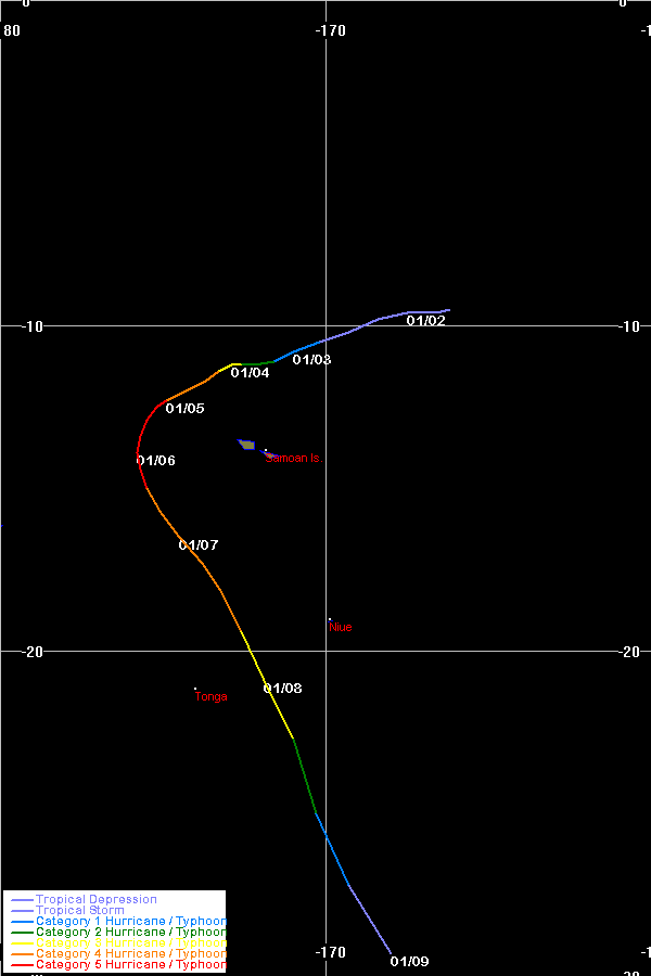
Tropical Cyclone Ron (TC-10P) 1-9 January
-------------------------------------------
Tropical Cyclone Ron, along with its twin, Susan, were the two most
intense cyclones to form in the South Pacific in recent years. Both
generated estimated 10-min average maximum sustained winds of 125 kts
(equivalent to 144 kts 1-min average) with attendant minimum central
pressure estimated at 900 mb. The last tropical cyclone to possibly
reach this intensity was Tropical Cyclone Hina in March of 1985.
The first depression bulletin on the pre-Ron system was issued at
01/0600 UTC with the system centered about 450 nm northeast of Samoa.
The depression drifted slowly on a west-southwesterly course for the
next four days, reaching tropical cyclone intensity at 0000 UTC on
2 Jan about 350 nm northeast of Samoa. As a storm Ron passed very near
Swains Island around 03/0000 UTC. Intensification proceeded at a
fairly rapid rate after that. Peak intensity of 125 kts was reached
at 0600 UTC on 5 Jan with Ron centered about 225 nm north-northwest of
Apia in Western Samoa. The cyclone maintained this strength for about
36 hrs. After 1200 UTC on the 5th Ron turned to a south-southwesterly
course for about 18 hrs, then began to move in a south-southeasterly
direction. Around 06/1800 UTC the cyclone, with maximum winds still
estimated to be near 110 kts, passed very close to the island of
Niuafo'ou, where considerable destruction occurred. At 1800 UTC
Niuafo'ou reported sustained winds of 60 kts with a presure of 983.7
mb. The lowest pressure from the island during Ron's passage was
972.4 mb with maximum winds from 65-80 kts, but these winds were
estimated. Ron was a very compact cyclone--at 05/0000 UTC Wallis
Island, then located about 95 nm southeast of the center, reported
10-min average winds of only 17 kts with gusts to 32 kts. The Nadi
discussion at 06/0800 UTC mentioned that based on winds reported by
Niuafo'ou, Ron may have had an even smaller gale radius and stronger
winds near the center than had been thought.
After passing Niuafo'ou Ron began to weaken steadily as it started
to accelerate to the southeast. The storm passed over 400 nm south of
Samoa around 0000 UTC on 8 Jan with maximum winds estimated at 85 kts.
After this Ron began to move quickly to the southeast as it rapidly
weakened, and the system had merged with Tropical Cyclone Susan by
09/0000 UTC.
The greatest damage from Tropical Cyclone Ron occurred on the Tongan
island of Niuafo'ou (population 735). About 67% of the buildings were
either damaged or destroyed (many of these were Tongan fales--thatched
houses). Agricultural losses were also severe--from 80-90% of coconut
and breadfruit trees were damaged, and losses for native food crops
such as taro, kape, manioc, and bananas were estimated at 95%. _The
Tonga Chronicle_ reported that it would take about five years to bring
crop production back to pre-cyclone levels. The estimated cost for
rehabilitation (houses, food, water, etc) is placed at approximately
$1.1 million in Tongan dollars. Fortunately no deaths were reported.
Damage was also reported on the Tongan islands of Niuatoputapu,
Tafahi, and Vava'u but was generally not as severe as on Niuafo'ou.
No reports of damage have been received from Swains Island (which is
part of American Samoa) or from Wallis Island (a French territory).
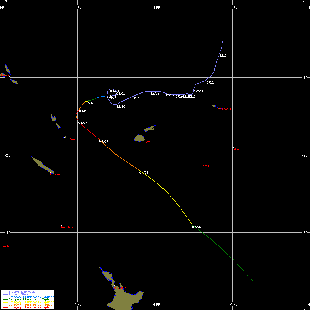
Tropical Cyclone Susan (TC-11P) 3-9 January
---------------------------------------------
Tropical Cyclone Susan developed from a disturbance which had
actually been tracked since around 20 December. The disturbance was
first noted several hundred miles northeast of Samoa. Over the next
two weeks the system drifted very slowly west-southwestward. Nadi had
issued a couple of bulletins on the system on 20 and 21 Dec, and again
from 24-26 Dec when the system became better organized; however, on
both occasions convection decreased and the system weakened. During
this time neither NPMOC nor JTWC issued depression warnings, although
Dvorak bulletins were issued sporadically on the LOW.
Finally at 0000 UTC on 3 Jan, Nadi resumed issuing depression
bulletins on the system which was then located west of Rotuma, and
Susan was named just 6 hrs later with the center placed about 450 nm
north of Fiji. Susan intensified rapidly, and only 18 hrs after being
named the storm had reached hurricane force. Tropical Cyclone Susan
initially moved slowly westward, then turned to a west-southwesterly
course. By 04/1200 UTC Susan was moving southwest, and after 1800 UTC
on 5 Jan, made a turn to the south-southeast. On the afternoon of
the 5th the storm came within about 225 nm of Vila, Vanuatu. Susan by
this time had reached its peak itensity of 125 kts sustained winds and
900 mb estimated central pressure. The cyclone posed a severe threat
to Vanuatu, but fortunately changed course in time to spare the islands
a direct hit.
After turning away from Vanuatu Susan began to track toward the
southeast at a faster rate of speed. Peak intensity was maintained
for about 36 hrs--until after 1200 UTC on 6 Jan. On 7 and 8 Jan Susan
passed closed enough to Fiji to cause some gales in the westernmost
islands of the group. The center passed about 200 nm south-southwest
of Nadi around 07/1800 UTC with winds still near 110 kts. At 2100 UTC
on the 7th a ship at 20.1S, 172.7E (about 250 nm west-northwest of the
center) reported winds of 50 kts. Susan appeared to have concentric
eyes on at least a couple of occasions.
After passing by Fiji Susan accelerated greatly on a southeasterly
course across the South Pacific. Cyclone Ron had merged with the
system by 09/0000 UTC and Susan was becoming extratropical by 0600 UTC
about 725 nm east-northeast of Auckland, New Zealand. Winds remained
well above hurricane force as Susan made the transition to a vigorous
extratropical cyclone.
Overall, damage from Tropical Cyclone Susan was minor. High seas
inundated Talaulia village on Kadavu, Fiji, and partly destroyed some
beachfront buildings, roads, jetties, and bridges on the island. On
Beqa Island damage from high seas/swells was also experienced. In
the town of Lautoka, on Viti Levu, roofs were blown off some shops.
This damage was believed to have been caused by a tornado which formed
in one of the outer rain bands as it crossed the shoreline. One death
was reported on Ambrym Island, Vanuatu, when a woman was struck and
killed by a falling coconut palm.
0 likes
-
HURAKAN
- Professional-Met
- Posts: 46086
- Age: 38
- Joined: Thu May 20, 2004 4:34 pm
- Location: Key West, FL
- Contact:
Tropical Disturbance Advisory Number A24 issued from RSMC NADI
Mar 02/2004 UTC 2005 UTC.
TROPICAL CYCLONE PERCY CENTRE [900 hPa] WAS LOCATED NEAR 18.5S 164.7W
AT 021800 UTC. POSITION FAIR BASED ON GOES9/10 EIR IMAGERY WITH
ANIMATION. CYCLONE MOVING SOUTHSOUTHEAST AT 10 KNOTS AND EXPECTED TO
GRADUALLY CURVE SOUTHEAST. 10-MINUTE AVERAGE WINDS ESTIMATED AT 125
KNOTS CLOSE TO THE CENTRE, DECREASING TO 115 KNOTS IN THE NEXT 6
HOURS. EXPECT WINDS OVER 63 KNOTS WITHIN 30 MILES OF CENTRE, OVER 47
KNOTS WITHIN 60 MILES OF CENTRE AND OVER 33 KNOTS WITHIN 180 MILES OF
CENTRE IN THE SOUTHEAST SEMICIRCLE AND WITHIN 120 MILES OF CENTRE
ELSEWHERE.
EYE HAS NOW FILLED AND INDICATES A WEAKENING TREND. DVORAK ANALYSIS
BASED ON EMBEDDED CENTRE WITH CMG SURROUNDING, YIELDING DT=MET=PT =
6.0; FT BASED ON DT: CI HELD SAME. T6.0/7.0/D0.5/24HRS. CIMMS
SUGGESTS AN INCREASE IN VERTICAL SHEAR OVER THE SYSTEM. OUTFLOW NOW
BECOMING RESTRICTED IN THE NORTHERN QUARDRANT BUT REMAINS STRONG
ELSEWHERE AND ENHANCED BY A JET ENTRANCE REGION TO THE FAR SOUTH.
CYCLONE IS BEING STEERED SOUTHWARDS AROUND THE WESTERN PERIPHERY OF A
MID-LEVEL RIDGE. THE SYSTEM IS EXPECTED TO CURVE SOUTHEAST IN THE
NEXT 24 TO 36 HOURS IN RESPONSE TO AN APPROACHING UPPER TROUGH FROM
THE WEST.
FORECASTS :
AT 12 HRS VALID AT 030600 UTC 20.4S 163.9W MOV SSE AT 10 KT WITH 115
KT CLOSE TO CENTRE
AT 24 HRS VALID AT 031800 UTC 22.6S 162.8W MOV SSE AT 10 KT WITH 95
KT CLOSE TO CENTRE
OUTLOOK :
AT 36 HRS VALID AT 040600 UTC 24.6S 160.8W MOV SSE AT 12 KT WITH 85
KT CLOSE TO CENTRE
AT 48 HRS VALID AT 041800 UTC 26.1S 158.4W MOV SE AT 12 KT WITH 75 KT
CLOSE TO CENTRE
THE NEXT TROPICAL DISTURBANCE ADVISORY ON TROPICAL CYCLONE PERCY WILL
BE ISSUED AROUND 030200 UTC.

PERCY CONTINUES TO LOSE ITS MAGESTIC IMAGE.
Mar 02/2004 UTC 2005 UTC.
TROPICAL CYCLONE PERCY CENTRE [900 hPa] WAS LOCATED NEAR 18.5S 164.7W
AT 021800 UTC. POSITION FAIR BASED ON GOES9/10 EIR IMAGERY WITH
ANIMATION. CYCLONE MOVING SOUTHSOUTHEAST AT 10 KNOTS AND EXPECTED TO
GRADUALLY CURVE SOUTHEAST. 10-MINUTE AVERAGE WINDS ESTIMATED AT 125
KNOTS CLOSE TO THE CENTRE, DECREASING TO 115 KNOTS IN THE NEXT 6
HOURS. EXPECT WINDS OVER 63 KNOTS WITHIN 30 MILES OF CENTRE, OVER 47
KNOTS WITHIN 60 MILES OF CENTRE AND OVER 33 KNOTS WITHIN 180 MILES OF
CENTRE IN THE SOUTHEAST SEMICIRCLE AND WITHIN 120 MILES OF CENTRE
ELSEWHERE.
EYE HAS NOW FILLED AND INDICATES A WEAKENING TREND. DVORAK ANALYSIS
BASED ON EMBEDDED CENTRE WITH CMG SURROUNDING, YIELDING DT=MET=PT =
6.0; FT BASED ON DT: CI HELD SAME. T6.0/7.0/D0.5/24HRS. CIMMS
SUGGESTS AN INCREASE IN VERTICAL SHEAR OVER THE SYSTEM. OUTFLOW NOW
BECOMING RESTRICTED IN THE NORTHERN QUARDRANT BUT REMAINS STRONG
ELSEWHERE AND ENHANCED BY A JET ENTRANCE REGION TO THE FAR SOUTH.
CYCLONE IS BEING STEERED SOUTHWARDS AROUND THE WESTERN PERIPHERY OF A
MID-LEVEL RIDGE. THE SYSTEM IS EXPECTED TO CURVE SOUTHEAST IN THE
NEXT 24 TO 36 HOURS IN RESPONSE TO AN APPROACHING UPPER TROUGH FROM
THE WEST.
FORECASTS :
AT 12 HRS VALID AT 030600 UTC 20.4S 163.9W MOV SSE AT 10 KT WITH 115
KT CLOSE TO CENTRE
AT 24 HRS VALID AT 031800 UTC 22.6S 162.8W MOV SSE AT 10 KT WITH 95
KT CLOSE TO CENTRE
OUTLOOK :
AT 36 HRS VALID AT 040600 UTC 24.6S 160.8W MOV SSE AT 12 KT WITH 85
KT CLOSE TO CENTRE
AT 48 HRS VALID AT 041800 UTC 26.1S 158.4W MOV SE AT 12 KT WITH 75 KT
CLOSE TO CENTRE
THE NEXT TROPICAL DISTURBANCE ADVISORY ON TROPICAL CYCLONE PERCY WILL
BE ISSUED AROUND 030200 UTC.
PERCY CONTINUES TO LOSE ITS MAGESTIC IMAGE.
0 likes
Who is online
Users browsing this forum: No registered users and 53 guests