TROPICAL DEPRESSION INVEST (AL932005) ON 20050729 0000 UTC
...00 HRS... ...12 HRS... ...24 HRS... ...36 HRS...
050729 0000 050729 1200 050730 0000 050730 1200
LAT LON LAT LON LAT LON LAT LON
BAMD 10.7N 40.9W 10.8N 43.8W 10.9N 46.6W 11.0N 49.4W
BAMM 10.7N 40.9W 10.6N 43.6W 10.6N 46.3W 10.6N 49.1W
A98E 10.7N 40.9W 10.5N 44.2W 10.6N 47.5W 10.9N 50.5W
LBAR 10.7N 40.9W 10.8N 44.3W 10.9N 47.9W 10.9N 51.6W
SHIP 20KTS 21KTS 24KTS 31KTS
DSHP 20KTS 21KTS 24KTS 31KTS
...48 HRS... ...72 HRS... ...96 HRS... ..120 HRS...
050731 0000 050801 0000 050802 0000 050803 0000
LAT LON LAT LON LAT LON LAT LON
BAMD 11.1N 52.1W 11.5N 56.8W 12.5N 60.1W 13.9N 63.2W
BAMM 10.7N 51.9W 11.4N 56.5W 13.1N 59.9W 14.9N 63.4W
A98E 10.8N 53.2W 11.6N 58.0W 12.2N 62.3W 13.7N 66.1W
LBAR 11.0N 55.3W 11.4N 61.8W 13.2N 66.4W 19.8N 64.7W
SHIP 39KTS 51KTS 56KTS 62KTS
DSHP 39KTS 51KTS 56KTS 62KTS
...INITIAL CONDITIONS...
LATCUR = 10.7N LONCUR = 40.9W DIRCUR = 265DEG SPDCUR = 16KT
LATM12 = 10.9N LONM12 = 37.7W DIRM12 = 267DEG SPDM12 = 16KT
LATM24 = 11.0N LONM24 = 34.5W
WNDCUR = 20KT RMAXWD = 45NM WNDM12 = 20KT
CENPRS = 1012MB OUTPRS = 1014MB OUTRAD = 150NM SDEPTH = M
RD34NE = 0NM RD34SE = 0NM RD34SW = 0NM RD34NW = 0NM
Finnally after being all day without a run 93L gets this 00:00z one.
93L Invest up
Moderator: S2k Moderators
Forum rules

The posts in this forum are NOT official forecasts and should not be used as such. They are just the opinion of the poster and may or may not be backed by sound meteorological data. They are NOT endorsed by any professional institution or STORM2K. For official information, please refer to products from the National Hurricane Center and National Weather Service.
-
cycloneye

- Admin

- Posts: 149505
- Age: 69
- Joined: Thu Oct 10, 2002 10:54 am
- Location: San Juan, Puerto Rico
0 likes
Visit the Caribbean-Central America Weather Thread where you can find at first post web cams,radars
and observations from Caribbean basin members Click Here
and observations from Caribbean basin members Click Here
-
WeatherEmperor
- S2K Supporter

- Posts: 4806
- Age: 42
- Joined: Thu Sep 04, 2003 2:54 pm
- Location: South Florida
yoda wrote:jlauderdal wrote:yoda wrote:PLEASE have this move toward the East Coast... FL and the Gulf need to be spared...
huh...miami, fort laud and jacksonville are in florida on the east coast
Ok...
I meant somewhere other than FL...
I don't need to be spared....I haven't seen any real hurricane action since Andrew. Not that I want another Andrew, but....I'll admit it, I enjoy hurricanes.
0 likes
-
cycloneye
- Admin
- Posts: 149505
- Age: 69
- Joined: Thu Oct 10, 2002 10:54 am
- Location: San Juan, Puerto Rico
WeatherEmperor wrote:I dont understand Cycloneye. Isnt 93L already dead? I cant see it on satellite anymore.
<RICKY>
In sattellite you can see it way down SE of 92L.
0 likes
Visit the Caribbean-Central America Weather Thread where you can find at first post web cams,radars
and observations from Caribbean basin members Click Here
and observations from Caribbean basin members Click Here
-
johngaltfla

- Category 5

- Posts: 2073
- Joined: Sun Jul 10, 2005 9:17 pm
- Location: Sarasota County, FL
- Contact:

-
cycloneye
- Admin
- Posts: 149505
- Age: 69
- Joined: Thu Oct 10, 2002 10:54 am
- Location: San Juan, Puerto Rico

00:00z run now at graphic.
0 likes
Visit the Caribbean-Central America Weather Thread where you can find at first post web cams,radars
and observations from Caribbean basin members Click Here
and observations from Caribbean basin members Click Here
-
cycloneye
- Admin
- Posts: 149505
- Age: 69
- Joined: Thu Oct 10, 2002 10:54 am
- Location: San Juan, Puerto Rico
WeatherEmperor wrote:I dont understand Cycloneye. Isnt 93L already dead? I cant see it on satellite anymore.
<RICKY>
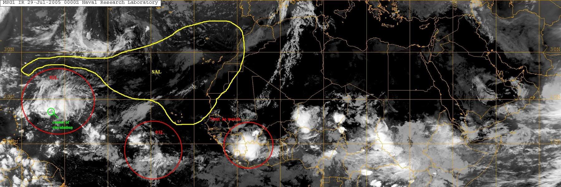
I thought it was dead myself but tonight it is making a little comeback with some more convection than in the past 24 hours around a center maybe a midlevel one.

0 likes
Visit the Caribbean-Central America Weather Thread where you can find at first post web cams,radars
and observations from Caribbean basin members Click Here
and observations from Caribbean basin members Click Here
-
wxwatcher91

- Category 5
- Posts: 1605
- Joined: Wed Jul 06, 2005 2:43 pm
- Location: Keene, NH
- Contact:
-
gkrangers
-
cycloneye
- Admin
- Posts: 149505
- Age: 69
- Joined: Thu Oct 10, 2002 10:54 am
- Location: San Juan, Puerto Rico
212
ABNT20 KNHC 290231
TWOAT
TROPICAL WEATHER OUTLOOK
NWS TPC/NATIONAL HURRICANE CENTER MIAMI FL
1030 PM EDT THU JUL 28 2005
FOR THE NORTH ATLANTIC...CARIBBEAN SEA AND THE GULF OF MEXICO...
THE NATIONAL HURRICANE CENTER IS ISSUING ADVISORIES ON TROPICAL
STORM FRANKLIN... LOCATED ABOUT 415 MILES SOUTH-SOUTHWEST OF HALIFAX
NOVA SCOTIA.
A WESTWARD-MOVING TROPICAL WAVE IS LOCATED ABOUT 1100 MILES
WEST-SOUTHWEST OF THE CAPE VERDE ISLANDS. SHOWER AND THUNDERSTORM
ACTIVITY REMAINS LIMITED...AND THERE ARE NO SIGNS OF ORGANIZATION
AT THIS TIME.
ELSEWHERE...TROPICAL STORM FORMATION IS NOT EXPECTED THROUGH FRIDAY.
FORECASTER BEVEN
Note:The TWO for 92L is posted at the 92L thread.
0 likes
Visit the Caribbean-Central America Weather Thread where you can find at first post web cams,radars
and observations from Caribbean basin members Click Here
and observations from Caribbean basin members Click Here
Who is online
Users browsing this forum: Iceresistance, Kingarabian and 304 guests