Issued at 12:55 pm WDT on Saturday, 10 March 2007
BY THE BUREAU OF METEOROLOGY
TROPICAL CYCLONE WARNING CENTRE PERTH
A CYCLONE WARNING for a SEVERE CATEGORY 3 cyclone is current for coastal areas
from Onslow to Port Hedland.
A CYCLONE WATCH continues for coastal areas from Coral Bay to Onslow and Port
Hedland to Bidyadanga, and extending into the inland Pilbara to include
Paraburdoo, Tom Price, Newman, Nullagine and Marble Bar
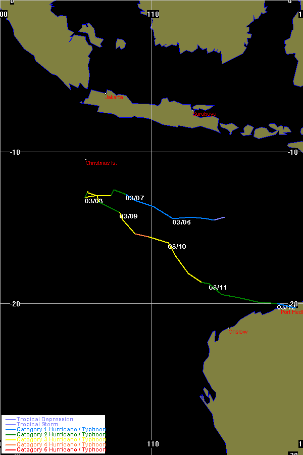
At 12:00 pm WDT Severe Tropical Cyclone Jacob was estimated to be
770 kilometres northwest of Karratha and
900 kilometres west northwest of Port Hedland and
moving southeast at 19 kilometres per hour.
Severe Tropical Cyclone Jacob is expected to continue its southeast track in the
next 24 to 48 hours towards the Pilbara coast. Gales may commence on the Pilbara
coast between Onslow and Port Hedland as early as late Sunday afternoon and a
coastal crossing is possible overnight into Monday morning.
The system has shown recent signs of weakening. A Category 4 impact is now
considered less likely however residents should continue to plan for impact of a
severe tropical cyclone. At this stage it is not expected to reach the same
intensity as TC George prior to landfall.
Details of Severe Tropical Cyclone Jacob at 12:00 pm WDT.
Location of centre : within 55 kilometres of
latitude 16.5 south longitude 111.1 east
Recent movement : southeast at 19 kilometres per hour.
Central Pressure : 964 hectopascals
Maximum wind gusts : 170 kilometres per hour near the centre.
Severity category : 3
FESA-State Emergency Service advises the following community alerts:
BLUE ALERT: People in or near coastal communities between Pardoo and Onslow
should commence taking precautions.
Other communities between Coral Bay and Bidyadanga, including the inland
Pilbara, should listen for the next advice.
The next warning will be issued by 4:00 pm WDT Saturday 10 March.
Cyclone advices and State Emergency Service Community Alerts are available by
dialling 1300 659 210
A map showing the track of the cyclone is available at:
http://www.bom.gov.au/weather/wa/cyclone


Weakens a little bit but still a major threat because of George's prior impact.