Akash and Gonu thread
Moderator: S2k Moderators
Forum rules

The posts in this forum are NOT official forecasts and should not be used as such. They are just the opinion of the poster and may or may not be backed by sound meteorological data. They are NOT endorsed by any professional institution or STORM2K. For official information, please refer to products from the National Hurricane Center and National Weather Service.
-
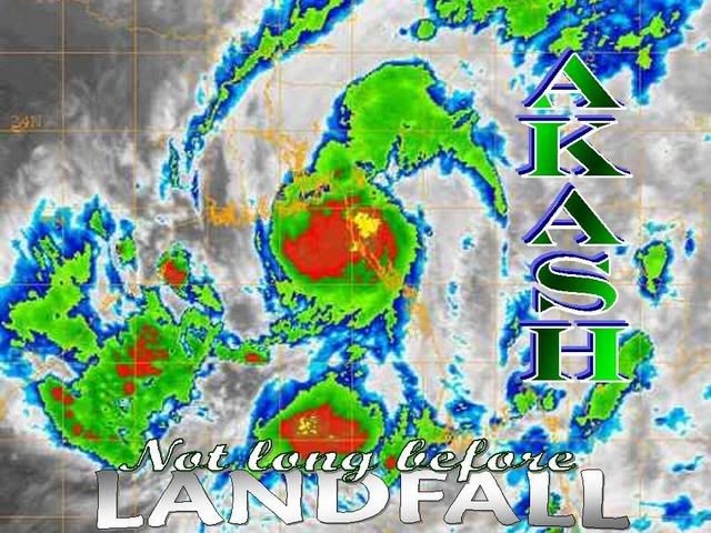
Matt-hurricanewatcher


BOB 02/2007/05 Dated : 14th May, 2007
Subject: Cyclonic Storm (AKASH) over Bay of Bengal
The deep depression over eastcentral Bay of Bengal intensified into a Cyclonic Storm (AKASH) and lay centred at 0830 hours IST of today, the 14th May, 2007 near Lat. 16.50 N and Long. 91.00 E, about 750 kms southeast of Kolkata. It is likely to intensify further and move in a north-northeasterly direction and cross south Bangladesh and adjoining north Arakan coast by tomorrow the 15th May afternoon.
Under its influence, widespread rains with isolated heavy to very heavy falls are likely to commence from tonight and continue for subsequent 48 hours over the northeastern states. Strong surface winds speed reaching 65-75 kmph are likely over Assam, Meghalaya, Tripura, Nagaland, Manipur and Mizoram during the same period.
Fairly widespread rainfall with isolated heavy falls are likely to commence over coastal areas over West Bengal from tonight onwards and continue for subsequent 48 hours. Squally winds with speed reaching 55-65 kmph are likely along and off West Bengal coast during the same period. The Sea condition will be very rough to high along and off West Bengal. The Fishermen are advised not to venture into sea.
Strong surface winds from south-southwesterly direction speed reaching 55-65 kmph are likely over north Andaman Sea during next 24 hours. The Sea condition will be very rough to high. Fishermen of the Andaman & Nicobar Islands are advised not to venture into sea.
[hr]
294
WTIN20 DEMS 140600
TROPICAL CYCLONE WARNING
RSMC NEW DELHI F/C
1. TROPICAL CYCLONE -AKASH- WARNING NR 01
ACTIVE TROPICAL CYCLONE IN BAY OF BENGAL
INITIAL POSITION
140000Z NEAR 16.0 N 90.5 E
ESTIMATED MAXIMUM SUSTAINED WIND 35 KTS
MOVEMENT PAST SIX HOURS 045DEG AT 3 KTS
FORECAST
06 HRS VALID AT: 140600 16.3N 90.8E
ESTIMATED MAXIMUM SUSTAINED WIND 40 KTS
12 HRS VALID AT: 141200 17.0N 91.3E
ESTIMATED MAXIMUM SUSTAINED WIND 40 KTS
18 HRS VALID AT: 141800 17.8N 91.8E
ESTIMATED MAXIMUM SUSTAINED WIND 40 KTS
24 HRS VALID AT: 150000 18.7N 91.9E
ESTIMATED MAXIMUM SUSTAINED WIND 40 KTS
30 HRS VALID AT: 150600 20.0N 92.6E
ESTIMATED MAXIMUM SUSTAINED WIND 40 KTS
36 HRS VALID AT: 151200 21.5N 92.8E
ESTIMATED MAXIMUM SUSTAINED WIND 35 KTS
42 HRS VALID AT: 151800 23.4N 93.2E
ESTIMATED MAXIMUM SUSTAINED WIND 30 KTS
48 HRS VALID AT: 160000 23.8N 92.4E
ESTIMATED MAXIMUM SUSTAINED WIND 20 KTS
NEXT WARNING AT 150600
0 likes
Up to 55 kt from JTWC.
TROPICAL CYCLONE (TC) 01B, LOCATED APPROXIMATELY 255 NM SOUTH
OF CHITTAGONG, BANGLADESH HAS TRACKED NORTHWARD AT 15 KNOTS OVER
THE PAST 06 HOURS. RECENT ANIMATED MULTISPECTRAL IMAGERY SHOWS
CONTINUED DEVELOPMENT OF THE SYSTEM, WITH A 140202Z SSMI/S MICROWAVE
IMAGE REVEALING DEEP CONVECTION FULLY WRAPPING AROUND THE LOW LEVEL
CIRCULATION CENTER. THE SYSTEM IS CURRENTLY BEING STEERED ON THE
WESTERN PERIPHERY OF A MID LEVEL RIDGE EXTENDING FROM THE SOUTH CHINA
SEA INTO EASTERN MYANMAR. TC 01B WILL CONTINUE TO TRACK TO THE NORTH
TOWARD THE BREAK IN THE RIDGE INDUCED BY A MIDLATITUDE TROUGH OVER
EASTERN INDIA/BANGLADESH. UPPER LEVEL ANALYSIS REVEALS AN ENVIRONMENT
FAVORABLE FOR CONTINUED INTENSIFICATION WITH A GOOD POLEWARD OUTFLOW
CHANNEL AUGMENTED BY THE MIDLATITUDE TROUGH OVER INDIA, AND A 200 MB
ANTICYCLONE OVER THE SYSTEM. THE STORM WILL CONTINUE TO INTENSIFY
PRIOR TO LANDFALL JUST AFTER TAU 12. MAXIMUM SIGNIFICANT WAVE HEIGHT
AT 140600Z IS 18 FEET. NEXT WARNINGS AT 142100Z AND 150900Z.//
0 likes

-
P.K.

- Professional-Met

- Posts: 5149
- Joined: Thu Sep 23, 2004 5:57 pm
- Location: Watford, England
- Contact:
FKIN20 VIDP 141049
TC ADVISORY
-----------
DTG: 20070514/0600Z
TCAC: NEW DELHI
TC: AKASH
NR: 01
PSN: N1700E09100
MOV: NNE05KT
C: 994HPA
MAX WIND: 40KT GUSTING TO 50KT
FCST PSN + 12HRS: 141800 N1800 E09130
MAX WIND + 12HRS: 45KT
FCST PSN + 18HRS: 150000 N1900 E09200
MAX WIND + 18HRS: 50KT
FCST PSN + 24HRS: 150600 N2000 E09230
MAX WIND + 24HRS: 55KT
NEXT MSG: 20070514/1200Z
---------
0 likes


-
HURAKAN

- Professional-Met
- Posts: 46084
- Age: 39
- Joined: Thu May 20, 2004 4:34 pm
- Location: Key West, FL
- Contact:
BOB 02/2007/10 Dated: 15th May, 2007
Subject: Cyclonic Storm “AKASH” over Bay of Bengal
The Cyclonic Storm “AKASH” over eastcentral Bay of Bengal moved northeastward and lay centred at 2330 hours IST of today, the 14th May, 2007 near Lat. 20.00 N and Long. 92.00 E, about 500 kms southeast of Kolkata. It is likely to move in a north-northeasterly direction and cross south Bangladesh and adjoining north Arakan coast (Myanmar) by today, the 15th May morning.
Under its influence rain/thundershowers at most places with heavy to very heavy falls at a few places are likely over the northeastern states during next 48 hours. Strong surface winds speed reaching 65-75 kmph are likely over Tripura, Mizoram, Assam, Meghalaya, Manipur and Nagaland during next 24 hours.
Rain/thundershowers at many places with isolated heavy falls are likely over coastal areas of West Bengal during next 36 hours. Gale winds with speed reaching 60-70 kmph are likely along and off West Bengal coast during next 24 hours. The Sea condition will be very rough to high along and off West Bengal coast. The Fishermen are advised not to venture into sea.
Strong surface winds from southwesterly direction with speed reaching 45-50 kmph are likely over north Andaman Sea during next 12 hours. The Sea condition will be rough to very rough. Fishermen of the Andaman & Nicobar Islands are advised not to venture into sea.
0 likes
Who is online
Users browsing this forum: No registered users and 263 guests