Seasonal Indicators (Beyond Day 16): Instability / SST's / MSLP / Steering / Sal
Moderator: S2k Moderators
Forum rules

The posts in this forum are NOT official forecasts and should not be used as such. They are just the opinion of the poster and may or may not be backed by sound meteorological data. They are NOT endorsed by any professional institution or STORM2K. For official information, please refer to products from the National Hurricane Center and National Weather Service.
-
wxman57

- Moderator-Pro Met

- Posts: 23173
- Age: 68
- Joined: Sat Jun 21, 2003 8:06 pm
- Location: Houston, TX (southwest)
Re: Seasonal Indicators (Beyond Day 15): Instability / SST's / MSLP / Steering / Sal
I think it was a combination of stronger-than-normal wind shear across the deep tropics (mostly due to El Nino) and plenty of dry, sinking air that killed the 2014 and 2015 seasons in the deep tropics. Early signs are that both of those have reversed for 2016. While I don't expect any Atlantic development over the next 2-3 weeks, I think the season will spring to life by the second week of August.
1 likes

Re: Seasonal Indicators (Beyond Day 15): Instability / SST's / MSLP / Steering / Sal
CFS is continuing to show a tropical storm or hurricane hitting Florida from the east in the last days of July/first days of August, followed by a second (much stronger storm) at the end of August--the timing is highly doubtful as to whether it's correct this far out, but the takeaway is that the steering flow is leaning towards more W-WNW systems in the subtropics, and combined with the lower shear, the pattern is much more favorable for landfalling systems this year.
1 likes
The above post is not official and should not be used as such. It is the opinion of the poster and may or may not be backed by sound meteorological data. It is not endorsed by any professional institution or storm2k.org. For official information, please refer to the NHC and NWS products.

Re: Seasonal Indicators (Beyond Day 15): Instability / SST's / MSLP / Steering / Sal
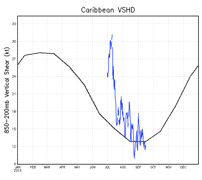
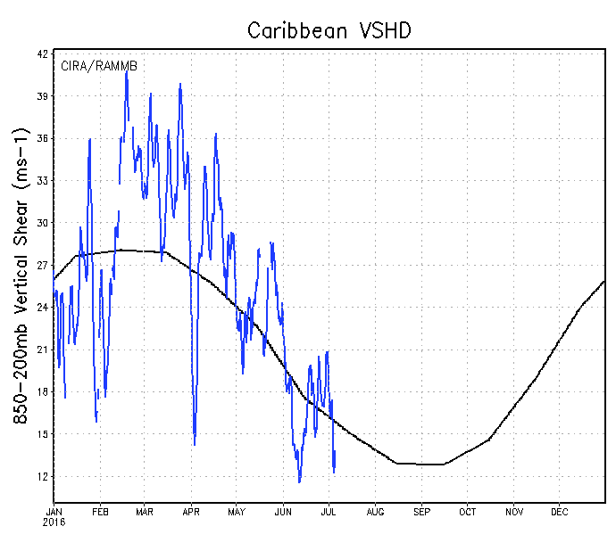
What a difference a year makes, from record breaking windshear over the Caribbean to near average over all since the official beginning of the hurricane season.
CFS showing below average windshear along with lowering MSLPs towards the end of the month, its precipitation forecast perhaps telling us that track of tropical waves and or possible storms.
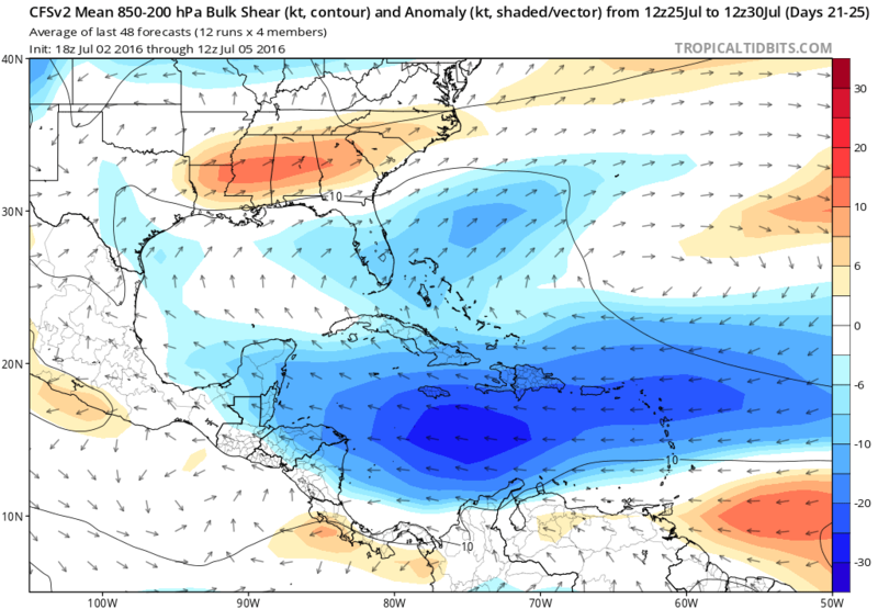
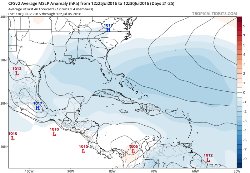
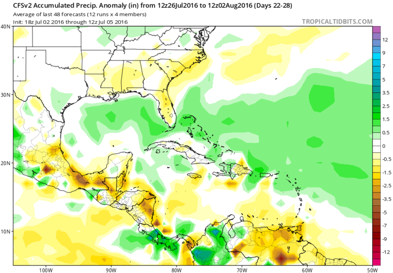
CFS showing below average windshear along with lowering MSLPs towards the end of the month, its precipitation forecast perhaps telling us that track of tropical waves and or possible storms.
3 likes


Re: Seasonal Indicators (Beyond Day 15): Instability / SST's / MSLP / Steering / Sal
Hammy wrote:CFS is continuing to show a tropical storm or hurricane hitting Florida from the east in the last days of July/first days of August, followed by a second (much stronger storm) at the end of August--the timing is highly doubtful as to whether it's correct this far out, but the takeaway is that the steering flow is leaning towards more W-WNW systems in the subtropics, and combined with the lower shear, the pattern is much more favorable for landfalling systems this year.
I can't upload the image but thought it was an interesting read from Joe Bastardi. Don't know how the pattern will shape up for late July and beyond but for now, it looks ominous.
Joe Bastardi @BigJoeBastardi Jun 28 Pennsylvania, USA
2005 500 mb Aug-Oct vs SST analog 500 mb forecast gives our worry about high impact season some backing.
1 likes
The posts or stuff said are NOT an official forecast. Please look to the NHC and NWS for official forecasts and products.
Floyd-1999, Frances-2004, Jeanne-2004, Fay-2008, Beryl-2012, Debby-2012, Colin-2016, Hermine-2016, Julia-2016, Matthew-2016, Irma-2017, Elsa-2021, Idalia-2023, Debby-2024, Helene-2024.
Go Gators! Go Jags!
Floyd-1999, Frances-2004, Jeanne-2004, Fay-2008, Beryl-2012, Debby-2012, Colin-2016, Hermine-2016, Julia-2016, Matthew-2016, Irma-2017, Elsa-2021, Idalia-2023, Debby-2024, Helene-2024.
Go Gators! Go Jags!
Re: Seasonal Indicators (Beyond Day 15): Instability / SST's / MSLP / Steering / Sal
I just did a quick analysis of the last 13 El Nino hurricane seasons (all since 1970, so within reliable satellite era) and found an average of 8/4/1 and 50 ACE, last year was 11/4/2 with 63 ACE, so along with a more active MDR, and a much stronger last two months than we've seen in some time, it could have been an indication of better atmospheric conditions already returning. I remember a lot of talk about what would last year have looked like minus the shear--I won't discount getting the answer to that question this year.
0 likes
The above post is not official and should not be used as such. It is the opinion of the poster and may or may not be backed by sound meteorological data. It is not endorsed by any professional institution or storm2k.org. For official information, please refer to the NHC and NWS products.


-
WPBWeather

- S2K Supporter

- Posts: 535
- Age: 67
- Joined: Thu Jul 18, 2013 12:33 pm
Re: Seasonal Indicators (Beyond Day 15): Instability / SST's / MSLP / Steering / Sal
SFLcane wrote:CFS...
Now, where's that "Permanent Trough" when you need it??
0 likes
Re: Seasonal Indicators (Beyond Day 15): Instability / SST's / MSLP / Steering / Sal
JaxGator wrote:Hammy wrote:CFS is continuing to show a tropical storm or hurricane hitting Florida from the east in the last days of July/first days of August, followed by a second (much stronger storm) at the end of August--the timing is highly doubtful as to whether it's correct this far out, but the takeaway is that the steering flow is leaning towards more W-WNW systems in the subtropics, and combined with the lower shear, the pattern is much more favorable for landfalling systems this year.
I can't upload the image but thought it was an interesting read from Joe Bastardi. Don't know how the pattern will shape up for late July and beyond but for now, it looks ominous.
Joe Bastardi @BigJoeBastardi Jun 28 Pennsylvania, USA
2005 500 mb Aug-Oct vs SST analog 500 mb forecast gives our worry about high impact season some backing.


0 likes
Re: Seasonal Indicators (Beyond Day 15): Instability / SST's / MSLP / Steering / Sal
NDG wrote:JaxGator wrote:Hammy wrote:CFS is continuing to show a tropical storm or hurricane hitting Florida from the east in the last days of July/first days of August, followed by a second (much stronger storm) at the end of August--the timing is highly doubtful as to whether it's correct this far out, but the takeaway is that the steering flow is leaning towards more W-WNW systems in the subtropics, and combined with the lower shear, the pattern is much more favorable for landfalling systems this year.
I can't upload the image but thought it was an interesting read from Joe Bastardi. Don't know how the pattern will shape up for late July and beyond but for now, it looks ominous.
Joe Bastardi @BigJoeBastardi Jun 28 Pennsylvania, USA
2005 500 mb Aug-Oct vs SST analog 500 mb forecast gives our worry about high impact season some backing.
https://pbs.twimg.com/media/CmFdtK8UgAAnFQp.jpg
https://pbs.twimg.com/media/CmFeJvUVAAEHxD1.jpg
Thank you NDG.
0 likes
The posts or stuff said are NOT an official forecast. Please look to the NHC and NWS for official forecasts and products.
Floyd-1999, Frances-2004, Jeanne-2004, Fay-2008, Beryl-2012, Debby-2012, Colin-2016, Hermine-2016, Julia-2016, Matthew-2016, Irma-2017, Elsa-2021, Idalia-2023, Debby-2024, Helene-2024.
Go Gators! Go Jags!
Floyd-1999, Frances-2004, Jeanne-2004, Fay-2008, Beryl-2012, Debby-2012, Colin-2016, Hermine-2016, Julia-2016, Matthew-2016, Irma-2017, Elsa-2021, Idalia-2023, Debby-2024, Helene-2024.
Go Gators! Go Jags!
Re: Seasonal Indicators (Beyond Day 15): Instability / SST's / MSLP / Steering / Sal
Does this give credibility to what the CFS is showing, at least as far as steering and not necessarily storms at those particular times?
0 likes
The above post is not official and should not be used as such. It is the opinion of the poster and may or may not be backed by sound meteorological data. It is not endorsed by any professional institution or storm2k.org. For official information, please refer to the NHC and NWS products.
Re: Seasonal Indicators (Beyond Day 15): Instability / SST's / MSLP / Steering / Sal
I guess it might if the steering holds true, but they are similar.
0 likes
The posts or stuff said are NOT an official forecast. Please look to the NHC and NWS for official forecasts and products.
Floyd-1999, Frances-2004, Jeanne-2004, Fay-2008, Beryl-2012, Debby-2012, Colin-2016, Hermine-2016, Julia-2016, Matthew-2016, Irma-2017, Elsa-2021, Idalia-2023, Debby-2024, Helene-2024.
Go Gators! Go Jags!
Floyd-1999, Frances-2004, Jeanne-2004, Fay-2008, Beryl-2012, Debby-2012, Colin-2016, Hermine-2016, Julia-2016, Matthew-2016, Irma-2017, Elsa-2021, Idalia-2023, Debby-2024, Helene-2024.
Go Gators! Go Jags!
-
gatorcane

- S2K Supporter
- Posts: 23708
- Age: 48
- Joined: Sun Mar 13, 2005 3:54 pm
- Location: Boca Raton, FL
Re: Seasonal Indicators (Beyond Day 15): Instability / SST's / MSLP / Steering / Sal
I don't remember the super long-range CFS showing much of anything this time last year as far as Atlantic development. It seems to be showing multiple systems in the super-long range already.
0 likes
-
Hurricaneman

- Category 5

- Posts: 7404
- Age: 45
- Joined: Tue Aug 31, 2004 3:24 pm
- Location: central florida
Re: Seasonal Indicators (Beyond Day 15): Instability / SST's / MSLP / Steering / Sal
Likely the last few days of the month through early October will be really busy and with steering currents like are predicted the east coast and eastern gulf need to pay very close attention during that time period, looks very similar to 1985, 1998 and 2004
The posts in this forum are NOT official forecast and should not be used as such. They are just the opinion of the poster and may or may not be backed by sound meteorological data. They are NOT endorsed by any professional institution or STORM2K. For official information, please refer to products from the National Hurricane Center and National Weather Service
The posts in this forum are NOT official forecast and should not be used as such. They are just the opinion of the poster and may or may not be backed by sound meteorological data. They are NOT endorsed by any professional institution or STORM2K. For official information, please refer to products from the National Hurricane Center and National Weather Service
1 likes

Re: 2016 indicators: Instability / SST's / MSLP / Steering / Sal
FireRat wrote::uarrow: And we know how 1998 turned out to be folks.
That is one heck of an analog year so far, we might see a very eventful year if this season blows up in August - September like that year, and let's not forget the Caribbean late season as well if indeed things remain 1998-ish by Oct-Nov.
1998 was a brutal season for sure with Georges and Mitch.
2 likes

Re: Seasonal Indicators (Beyond Day 15): Instability / SST's / MSLP / Steering / Sal
NDG wrote:JaxGator wrote:Hammy wrote:CFS is continuing to show a tropical storm or hurricane hitting Florida from the east in the last days of July/first days of August, followed by a second (much stronger storm) at the end of August--the timing is highly doubtful as to whether it's correct this far out, but the takeaway is that the steering flow is leaning towards more W-WNW systems in the subtropics, and combined with the lower shear, the pattern is much more favorable for landfalling systems this year.
I can't upload the image but thought it was an interesting read from Joe Bastardi. Don't know how the pattern will shape up for late July and beyond but for now, it looks ominous.
Joe Bastardi @BigJoeBastardi Jun 28 Pennsylvania, USA
2005 500 mb Aug-Oct vs SST analog 500 mb forecast gives our worry about high impact season some backing.
That's pretty close to a nightmare scenario at 500mb. I think it would/could be worse if the heights were centered about 200 miles farther south. But still, heights like those over the eastern Great Lakes and Northeast US for any length of time during the peak of the season conceivably set up a conveyer belt toward Florida and the SE US. Let's hope if semi-permanent high pressure sets up for a few weeks/months in the northeast that it's during a down pulse of MJO and source waves.
1 likes
-
1900hurricane

- Category 5
- Posts: 6063
- Age: 34
- Joined: Fri Feb 06, 2015 12:04 pm
- Location: Houston, TX
- Contact:
Re: Seasonal Indicators (Beyond Day 15): Instability / SST's / MSLP / Steering / Sal
I'm not sure if this will impact the season or not, but South American drought is very bad right now. I can't remember if I saw someone trying to say that South American drought helped contribute to the 2013 flop (didn't see a mention on a quick scan of the Wiki page for what it's worth).
http://earthobservatory.nasa.gov/IOTD/view.php?id=88308&src=ve
http://earthobservatory.nasa.gov/IOTD/view.php?id=88308&src=ve
1 likes
Contract Meteorologist. TAMU & MSST. Fiercely authentic, one of a kind. We are all given free will, so choose a life meant to be lived. We are the Masters of our own Stories.
Opinions expressed are mine alone.
Follow me on Twitter at @1900hurricane : Read blogs at https://1900hurricane.wordpress.com/
Opinions expressed are mine alone.
Follow me on Twitter at @1900hurricane : Read blogs at https://1900hurricane.wordpress.com/
-
tarheelprogrammer

- S2K Supporter
- Posts: 1793
- Joined: Mon Mar 28, 2016 9:25 pm
- Location: Raleigh, NC area (Garner, NC)
Re: Seasonal Indicators (Beyond Day 15): Instability / SST's / MSLP / Steering / Sal
1900hurricane wrote:I'm not sure if this will impact the season or not, but South American drought is very bad right now. I can't remember if I saw someone trying to say that South American drought helped contribute to the 2013 flop (didn't see a mention on a quick scan of the Wiki page for what it's worth).
http://earthobservatory.nasa.gov/IOTD/view.php?id=88308&src=ve
Good and hopefully this ends up being the nail in the coffin for this season.
0 likes
My posts are not official forecasts. They are just my opinion and may or may not be backed by sound meteorological data. They are NOT endorsed by any professional institution or storm2k.org. For official information, please refer to the NHC and NWS products.
-
WPBWeather
- S2K Supporter
- Posts: 535
- Age: 67
- Joined: Thu Jul 18, 2013 12:33 pm
Re: Seasonal Indicators (Beyond Day 15): Instability / SST's / MSLP / Steering / Sal
tarheelprogrammer wrote:1900hurricane wrote:I'm not sure if this will impact the season or not, but South American drought is very bad right now. I can't remember if I saw someone trying to say that South American drought helped contribute to the 2013 flop (didn't see a mention on a quick scan of the Wiki page for what it's worth).
http://earthobservatory.nasa.gov/IOTD/view.php?id=88308&src=ve
Good and hopefully this ends up being the nail in the coffin for this season.
Come on now. Don't throw a bomb. A SA drought has nothing to do with the ATL season. And, lets hope for a quiet season, but there only is hope, no science to say otherwise.
1 likes
-
tarheelprogrammer
- S2K Supporter
- Posts: 1793
- Joined: Mon Mar 28, 2016 9:25 pm
- Location: Raleigh, NC area (Garner, NC)
Re: Seasonal Indicators (Beyond Day 15): Instability / SST's / MSLP / Steering / Sal
WPBWeather wrote:tarheelprogrammer wrote:1900hurricane wrote:I'm not sure if this will impact the season or not, but South American drought is very bad right now. I can't remember if I saw someone trying to say that South American drought helped contribute to the 2013 flop (didn't see a mention on a quick scan of the Wiki page for what it's worth).
http://earthobservatory.nasa.gov/IOTD/view.php?id=88308&src=ve
Good and hopefully this ends up being the nail in the coffin for this season.
Come on now. Don't throw a bomb. A SA drought has nothing to do with the ATL season. And, lets hope for a quiet season, but there only is hope, no science to say otherwise.
Positive vibes toward a slow season. The 500 mb set up is scary and it means we need less TWs.
0 likes
My posts are not official forecasts. They are just my opinion and may or may not be backed by sound meteorological data. They are NOT endorsed by any professional institution or storm2k.org. For official information, please refer to the NHC and NWS products.
-
1900hurricane
- Category 5
- Posts: 6063
- Age: 34
- Joined: Fri Feb 06, 2015 12:04 pm
- Location: Houston, TX
- Contact:
Re: Seasonal Indicators (Beyond Day 15): Instability / SST's / MSLP / Steering / Sal
To be fair, I don't remember where I read such a thing. It may end up having no correlation at all if it was mere speculation or if it was from an unreliable source.
1 likes
Contract Meteorologist. TAMU & MSST. Fiercely authentic, one of a kind. We are all given free will, so choose a life meant to be lived. We are the Masters of our own Stories.
Opinions expressed are mine alone.
Follow me on Twitter at @1900hurricane : Read blogs at https://1900hurricane.wordpress.com/
Opinions expressed are mine alone.
Follow me on Twitter at @1900hurricane : Read blogs at https://1900hurricane.wordpress.com/
Who is online
Users browsing this forum: No registered users and 292 guests