2021 EPAC Season
Moderator: S2k Moderators
Forum rules

The posts in this forum are NOT official forecasts and should not be used as such. They are just the opinion of the poster and may or may not be backed by sound meteorological data. They are NOT endorsed by any professional institution or STORM2K. For official information, please refer to products from the National Hurricane Center and National Weather Service.
-
Category5Kaiju

- Category 5

- Posts: 4334
- Joined: Thu Dec 24, 2020 12:45 pm
- Location: Seattle and Phoenix
Re: 2021 EPAC Season
NHC now has a second AOI in yellow
0 likes
Unless explicitly stated, all info in my posts is based on my own opinions and observations. Tropical storms and hurricanes can be extremely dangerous. Refer to an accredited weather research agency or meteorologist if you need to make serious decisions regarding an approaching storm.
-
cycloneye

- Admin

- Posts: 149508
- Age: 69
- Joined: Thu Oct 10, 2002 10:54 am
- Location: San Juan, Puerto Rico
Re: 2021 EPAC Season
93E comming soon.
GENESIS017, EP, E, , , , , 78, 2021, DB, O, 2021080512, 9999999999, , 017, , , , GENESIS, , EP782021
1 likes
Visit the Caribbean-Central America Weather Thread where you can find at first post web cams,radars
and observations from Caribbean basin members Click Here
and observations from Caribbean basin members Click Here
-
Kingarabian

- S2K Supporter

- Posts: 16366
- Joined: Sat Aug 08, 2009 3:06 am
- Location: Honolulu, Hawaii
Re: 2021 EPAC Season
18z GFS continues with two more systems following the two NHC circled AOI':

0 likes
RIP Kobe Bryant
-
cycloneye
- Admin
- Posts: 149508
- Age: 69
- Joined: Thu Oct 10, 2002 10:54 am
- Location: San Juan, Puerto Rico
Re: 2021 EPAC Season
An area of low pressure is expected to develop a few hundred miles
south of the Gulf of Tehuantepec by early next week. Environmental
conditions are forecast to be conducive for gradual development
thereafter while the system moves west-northwestward at about 10
mph, parallel to and offshore of the coast of southern Mexico.
* Formation chance through 48 hours...low...near 0 percent.
* Formation chance through 5 days...low...30 percent.
0 likes
Visit the Caribbean-Central America Weather Thread where you can find at first post web cams,radars
and observations from Caribbean basin members Click Here
and observations from Caribbean basin members Click Here

-
Category5Kaiju
- Category 5
- Posts: 4334
- Joined: Thu Dec 24, 2020 12:45 pm
- Location: Seattle and Phoenix
Re: 2021 EPAC Season
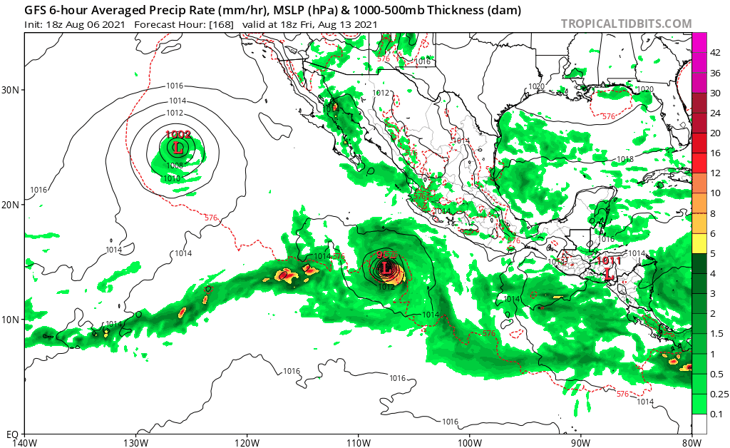
gatorcane wrote:The GFS is blowing up every cloud in the EPAC into a hurricane:
https://i.postimg.cc/xjbZFbwP/gfs-mslp-pcpn-epac-fh168-324-3.gif
Well no wonder why the GFS is also producing virtually nothing in the Atlantic....I mean, if the GFS's forecast verifies and the EPAC bombs out while the Atlantic stays calm, I think we may need to reconsider entirely our use of ENSO as a leading seasonal predictor. Now, I feel like GFS is being way too extreme with its EPAC prognosis, but there's definitely going to be some major rethinking to do should it actually verify. Time will tell though, it's August 6 after all, and the EPAC just got a CCKW boost
1 likes
Unless explicitly stated, all info in my posts is based on my own opinions and observations. Tropical storms and hurricanes can be extremely dangerous. Refer to an accredited weather research agency or meteorologist if you need to make serious decisions regarding an approaching storm.
-
Kingarabian
- S2K Supporter
- Posts: 16366
- Joined: Sat Aug 08, 2009 3:06 am
- Location: Honolulu, Hawaii
Re: 2021 EPAC Season
Category5Kaiju wrote:gatorcane wrote:The GFS is blowing up every cloud in the EPAC into a hurricane:
https://i.postimg.cc/xjbZFbwP/gfs-mslp-pcpn-epac-fh168-324-3.gif
Well no wonder why the GFS is also producing virtually nothing in the Atlantic....I mean, if the GFS's forecast verifies and the EPAC bombs out while the Atlantic stays calm, I think we may need to reconsider entirely our use of ENSO as a leading seasonal predictor. Now, I feel like GFS is being way too extreme with its EPAC prognosis, but there's definitely going to be some major rethinking to do should it actually verify. Time will tell though, it's August 6 after all, and the EPAC just got a CCKW boost
I don't think so. ENSO is probably the best indicator for hurricane potential in the Pacific and the Atlantic. We have decades worth of proof. I think we need to be comfortable with any outcome, and shouldn't be shocked that anomalies do occur sometimes, and things go against the norm.
That being said, there is nothing abnormal about the current period of enhanced EPAC activity. 2017 stayed active through mid September and look how that Atlantic hurricane season turned out.
9 likes
RIP Kobe Bryant
-
Category5Kaiju
- Category 5
- Posts: 4334
- Joined: Thu Dec 24, 2020 12:45 pm
- Location: Seattle and Phoenix
Re: 2021 EPAC Season
Kingarabian wrote:Category5Kaiju wrote:gatorcane wrote:The GFS is blowing up every cloud in the EPAC into a hurricane:
https://i.postimg.cc/xjbZFbwP/gfs-mslp-pcpn-epac-fh168-324-3.gif
Well no wonder why the GFS is also producing virtually nothing in the Atlantic....I mean, if the GFS's forecast verifies and the EPAC bombs out while the Atlantic stays calm, I think we may need to reconsider entirely our use of ENSO as a leading seasonal predictor. Now, I feel like GFS is being way too extreme with its EPAC prognosis, but there's definitely going to be some major rethinking to do should it actually verify. Time will tell though, it's August 6 after all, and the EPAC just got a CCKW boost
I don't think so. ENSO is probably the best indicator for hurricane potential in the Pacific and the Atlantic. We have decades worth of proof. I think we need to be comfortable with any outcome, and shouldn't be shocked that anomalies do occur sometimes, and things go against the norm.
That being said, there is nothing abnormal about the current period of enhanced EPAC activity. 2017 stayed active through mid September and look how that Atlantic hurricane season turned out.
Yeah, I guess you're right; maybe I should have reworded my thoughts in a better way. I think what I am trying to say is that while ENSO is definitely and understandably a very reliable predictor for general activity in the EPAC and Atlantic, I think it would be interesting to see if we can come up with ways in the future to analyze indicators other than the usual ENSO, sst anomalies, dry air, and so forth that are currently not very often looked at when predicting activity levels in general but could very well have some bearing on such. As you have said though, yes weird anomalies do happen, such as 2013 where the Atlantic and EPAC were pretty weak despite a cool ENSO, or 2004 when the EPAC was weak despite an El Nino. Perhaps we should study off of what exactly causes certain anomalies to occur and build upon such findings to find even better and more targeted ways to predict EPAC and Atlantic seasonal activities.
0 likes
Unless explicitly stated, all info in my posts is based on my own opinions and observations. Tropical storms and hurricanes can be extremely dangerous. Refer to an accredited weather research agency or meteorologist if you need to make serious decisions regarding an approaching storm.
-
Yellow Evan

- Professional-Met

- Posts: 16240
- Age: 27
- Joined: Fri Jul 15, 2011 12:48 pm
- Location: Henderson, Nevada/Honolulu, HI
- Contact:
Re: 2021 EPAC Season
An area of low pressure is expected to develop a few hundred miles
south of the Gulf of Tehuantepec by early next week. Environmental
conditions are forecast to be conducive for gradual development
thereafter, and a tropical depression could form by the middle of
next week while the system moves west-northwestward at about 10
mph, parallel to and offshore of the coast of southern Mexico.
* Formation chance through 48 hours...low...near 0 percent.
* Formation chance through 5 days...medium...40 percent.
0 likes
-
storminabox
- Category 1

- Posts: 263
- Joined: Sun Jul 09, 2017 10:50 pm
Re: 2021 EPAC Season
gatorcane wrote:The GFS is blowing up every cloud in the EPAC into a hurricane:
https://i.postimg.cc/xjbZFbwP/gfs-mslp-pcpn-epac-fh168-324-3.gif
It would be a sight to behold if this actually verified, but based on how this active stretch has been performing thus far, I kind of doubt it.
1 likes
-
Kingarabian
- S2K Supporter
- Posts: 16366
- Joined: Sat Aug 08, 2009 3:06 am
- Location: Honolulu, Hawaii
Re: 2021 EPAC Season
00z Euro makes the 0/40 a strong system:

The Euro and CMC continue to show hints of a 3rd system @ 240 hours as well:

The Euro and CMC continue to show hints of a 3rd system @ 240 hours as well:
1 likes
RIP Kobe Bryant
-
hurricanes1234
- Category 5
- Posts: 2908
- Joined: Sat Jul 28, 2012 6:19 pm
- Location: Trinidad and Tobago
Re: 2021 EPAC Season
The only thing active about this so-called "active stretch" is the number of systems that have been forming and the party of thunderstorms over the EPAC with the favourable MJO. 
Outside of that, nothing so far during this favourable MJO has intensified into anything of substance and definitely not into the monster storms the GFS has been showing. It's a (soon-to-be) La Niña year after all so it's not surprising that most things are weak and/or underperforming (just as they did last year as well for the most part). Like many others, I think in a matter of weeks, the focus will shift to the Atlantic and there's ample reason to believe it'll be more than just a bunch of sheared 35-knot systems.
Outside of that, nothing so far during this favourable MJO has intensified into anything of substance and definitely not into the monster storms the GFS has been showing. It's a (soon-to-be) La Niña year after all so it's not surprising that most things are weak and/or underperforming (just as they did last year as well for the most part). Like many others, I think in a matter of weeks, the focus will shift to the Atlantic and there's ample reason to believe it'll be more than just a bunch of sheared 35-knot systems.
Last edited by hurricanes1234 on Sat Aug 07, 2021 2:46 am, edited 1 time in total.
5 likes
PLEASE NOTE: With the exception of information from weather agencies that I may copy and paste here, my posts will NEVER be official, since I am NOT a meteorologist. They are solely my amateur opinion, and may or may not be accurate. Therefore, please DO NOT use them as official details, particularly when making important decisions. Thank you.
-
Kingarabian
- S2K Supporter
- Posts: 16366
- Joined: Sat Aug 08, 2009 3:06 am
- Location: Honolulu, Hawaii
Re: 2021 EPAC Season
In regards to quality, this next upcoming burst of activity might give us better eye candy. The predicted synoptic pattern favors quick moving systems, that track over different areas in the EPAC and are also well spaced out. Big reason why the trio of Hilda, Ignacio, and Jimena sucked is because they all waited to develop until they were 300-500 miles or less away from each other.
1 likes
RIP Kobe Bryant
-
Kingarabian
- S2K Supporter
- Posts: 16366
- Joined: Sat Aug 08, 2009 3:06 am
- Location: Honolulu, Hawaii
Re: 2021 EPAC Season
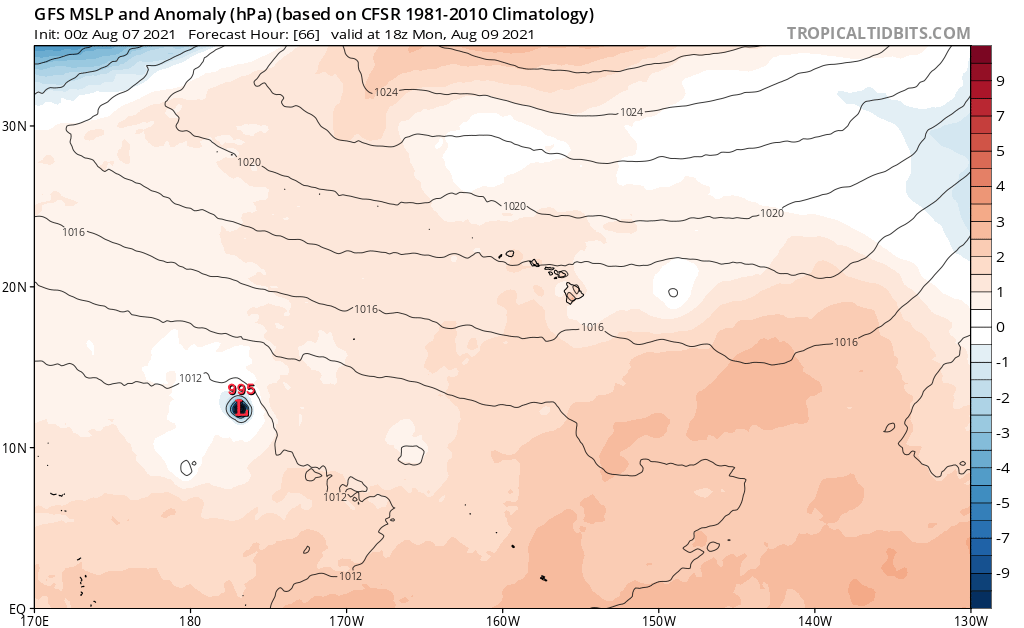
91C should be up soon:
For the central North Pacific...between 140W and 180W:
The Central Pacific Hurricane Center has issued the last advisory
on Post-Tropical Cyclone Jimena, located around 900 miles east of
Hilo, Hawaii.
1. An area of disturbed weather located around 1100 miles
south-southwest of Honolulu, Hawaii continues to produce a large
area of disorganized showers and thunderstorms. Environmental
conditions are forecast to remain conducive for some slow
development of this system during the next several days as it moves
west-northwest at 10 to 15 mph.
* Formation chance through 48 hours...low...20 percent.
* Formation chance through 5 days...low...30 percent.
Elsewhere, no tropical cyclones are expected during the next 5 days.
Forecaster Jelsema
0 likes
RIP Kobe Bryant
-
cycloneye
- Admin
- Posts: 149508
- Age: 69
- Joined: Thu Oct 10, 2002 10:54 am
- Location: San Juan, Puerto Rico
Re: 2021 EPAC Season
An area of low pressure is expected to develop a few hundred miles
south of the Gulf of Tehuantepec by early next week. Environmental
conditions are forecast to be conducive for gradual development
thereafter, and a tropical depression could form by the middle of
next week while the system moves west-northwestward at about 10
mph, parallel to and offshore of the coast of southern Mexico.
* Formation chance through 48 hours...low...near 0 percent.
* Formation chance through 5 days...medium...50 percent.
0 likes
Visit the Caribbean-Central America Weather Thread where you can find at first post web cams,radars
and observations from Caribbean basin members Click Here
and observations from Caribbean basin members Click Here
-
Category5Kaiju
- Category 5
- Posts: 4334
- Joined: Thu Dec 24, 2020 12:45 pm
- Location: Seattle and Phoenix
Re: 2021 EPAC Season
hurricanes1234 wrote:The only thing active about this so-called "active stretch" is the number of systems that have been forming and the party of thunderstorms over the EPAC with the favourable MJO.
Outside of that, nothing so far during this favourable MJO has intensified into anything of substance and definitely not into the monster storms the GFS has been showing. It's a (soon-to-be) La Niña year after all so it's not surprising that most things are weak and/or underperforming (just as they did last year as well for the most part). Like many others, I think in a matter of weeks, the focus will shift to the Atlantic and there's ample reason to believe it'll be more than just a bunch of sheared 35-knot systems.
Imho what we are seeing now is a very frontloaded EPAC season. With where we are headed with ENSO and the -PDO, I doubt it will be this active in September or October
2 likes
Unless explicitly stated, all info in my posts is based on my own opinions and observations. Tropical storms and hurricanes can be extremely dangerous. Refer to an accredited weather research agency or meteorologist if you need to make serious decisions regarding an approaching storm.

Re: 2021 EPAC Season
The EPac season is currently at 44.2 ACE and 176.55 ICE (my intensity metric that’s like instantaneous ACE). Since most of the storms have been weak and struggling, Felicia dominates these totals — it accounts for 53.1% of the season’s ICE and 48.4% of the ACE so far.
1 likes
Irene '11 Sandy '12 Hermine '16 5/15/2018 Derecho Fay '20 Isaias '20 Elsa '21 Henri '21 Ida '21
I am only a meteorology enthusiast who knows a decent amount about tropical cyclones. Look to the professional mets, the NHC, or your local weather office for the best information.
I am only a meteorology enthusiast who knows a decent amount about tropical cyclones. Look to the professional mets, the NHC, or your local weather office for the best information.
-
Yellow Evan
- Professional-Met
- Posts: 16240
- Age: 27
- Joined: Fri Jul 15, 2011 12:48 pm
- Location: Henderson, Nevada/Honolulu, HI
- Contact:


-
cycloneye
- Admin
- Posts: 149508
- Age: 69
- Joined: Thu Oct 10, 2002 10:54 am
- Location: San Juan, Puerto Rico
Re: 2021 EPAC Season
An area of low pressure is expected to develop a few hundred miles
south of the Gulf of Tehuantepec by early next week. Environmental
conditions are forecast to be conducive for development thereafter,
and a tropical depression is likely to form by the middle of next
week while the system moves west-northwestward at about 10 mph,
parallel to and offshore of the coast of southern Mexico.
* Formation chance through 48 hours...low...10 percent.
* Formation chance through 5 days...high...70 percent.
0 likes
Visit the Caribbean-Central America Weather Thread where you can find at first post web cams,radars
and observations from Caribbean basin members Click Here
and observations from Caribbean basin members Click Here
-
Category5Kaiju
- Category 5
- Posts: 4334
- Joined: Thu Dec 24, 2020 12:45 pm
- Location: Seattle and Phoenix
Re: 2021 EPAC Season
aspen wrote:The EPac season is currently at 44.2 ACE and 176.55 ICE (my intensity metric that’s like instantaneous ACE). Since most of the storms have been weak and struggling, Felicia dominates these totals — it accounts for 53.1% of the season’s ICE and 48.4% of the ACE so far.
We'll see what Kevin does, but it's a bit surprising that the EPAC has only generated one major hurricane so far. The last time something like this happened was in 2013 (when there were no MHs by now), and even years like 2010, 2011, 2012, 2017, and 2020 had at least two MHs by August 7.
1 likes
Unless explicitly stated, all info in my posts is based on my own opinions and observations. Tropical storms and hurricanes can be extremely dangerous. Refer to an accredited weather research agency or meteorologist if you need to make serious decisions regarding an approaching storm.
Who is online
Users browsing this forum: No registered users and 197 guests