2023 Indicators (SST, SAL, MSLP, Wind shear, Steering, Instability) and Day 16+ Models

This is the general tropical discussion area. Anyone can take their shot at predicting a storms path.

Moderator: S2k Moderators

Forum rules

The posts in this forum are NOT official forecasts and should not be used as such. They are just the opinion of the poster and may or may not be backed by sound meteorological data. They are NOT endorsed by any professional institution or STORM2K. For official information, please refer to products from the National Hurricane Center and National Weather Service.

Help Support Storm2K
Message
Author
User avatar
Teban54
Category 5
Category 5
Posts: 3206
Joined: Sat May 19, 2018 1:19 pm

Re: 2023 Indicators (SST, SAL, MSLP, Wind shear, Steering, Instability) and Day 16+ Models

#801 Postby Teban54 » Mon Jul 10, 2023 1:23 pm

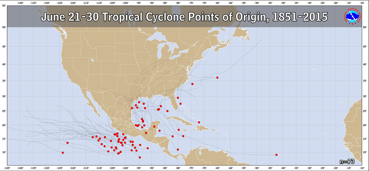
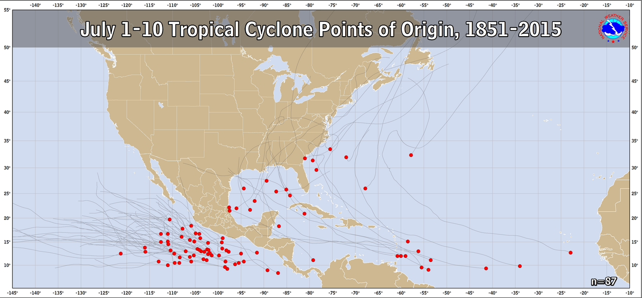
I'm sure most people already know this, but just as a refresher:
Image
Image
Having a storm develop where and when Bret and Cindy did is highly anomalous, especially for an El Nino year. This shouldn't have happened in the first place.

Having a storm develop where and when 93E failed to do so is normal, especially for an El Nino year. Most systems like 93E should have little difficulty developing.

And we haven't talked about intensity yet. Even though Bret failed to become a hurricane, an average Atlantic season doesn't get its first hurricane until August 11. On the other hand, many El Nino seasons in the EPac already had one or more majors and Cat 4s on this date, or were just about to get them. 2014 had two Cat 4s, 2015 was getting its 3rd, 2018 had two.

El Nino alone does not define seasonal activity. Just like La Nina alone doesn't (see last year).
7 likes   

tolakram
Admin
Admin
Posts: 20010
Age: 62
Joined: Sun Aug 27, 2006 8:23 pm
Location: Florence, KY (name is Mark)

Re: 2023 Indicators (SST, SAL, MSLP, Wind shear, Steering, Instability) and Day 16+ Models

#802 Postby tolakram » Mon Jul 10, 2023 2:42 pm

ThomasW wrote:For all the talk about how 93E "busted"... at least the EPAC can [*]get[*] invests right now. The North Atlantic can't even manage a yellow MDR crayon! El Nino is here folks, as is about to be evidenced by 94E. I think my 11/4/1 forecast is well on track in the Atlantic.


Seems high for an el nino year. :lol:
1 likes   
M a r k
- - - - -
Join us in chat: Storm2K Chatroom Invite. Android and IOS apps also available.

The posts in this forum are NOT official forecasts and should not be used as such. Posts are NOT endorsed by any professional institution or STORM2K.org. For official information and forecasts, please refer to NHC and NWS products.

User avatar
ElectricStorm
Category 5
Category 5
Posts: 5045
Age: 24
Joined: Tue Aug 13, 2019 11:23 pm
Location: Skiatook, OK / Norman, OK

Re: 2023 Indicators (SST, SAL, MSLP, Wind shear, Steering, Instability) and Day 16+ Models

#803 Postby ElectricStorm » Mon Jul 10, 2023 4:13 pm

ThomasW wrote:
NotSparta wrote:
ThomasW wrote:So two storms that actually "busted"? Right. The pattern which supported those is gone too


At least they could develop unlike 93E

93E would've been designated if it was in the West Pacific

What does that have to do with any of this? And no it probably wouldn't since it was never close to a TC. And I'm not really sure why you think Bret and Cindy were busts since the fact they even existed in the first place was a massive overperformance...
0 likes   
B.S Meteorology, University of Oklahoma '25

Please refer to the NHC, NWS, or SPC for official information.

User avatar
weeniepatrol
Category 5
Category 5
Posts: 1276
Joined: Sat Aug 22, 2020 5:30 pm
Location: WA State

Re: 2023 Indicators (SST, SAL, MSLP, Wind shear, Steering, Instability) and Day 16+ Models

#804 Postby weeniepatrol » Mon Jul 10, 2023 4:47 pm

That season to date mdr easterly shear is wild given the amplitude of El Niño.
2 likes   

User avatar
Iceresistance
Category 5
Category 5
Posts: 9288
Age: 21
Joined: Sat Oct 10, 2020 9:45 am
Location: Tecumseh, OK/Norman, OK

Re: 2023 Indicators (SST, SAL, MSLP, Wind shear, Steering, Instability) and Day 16+ Models

#805 Postby Iceresistance » Mon Jul 10, 2023 4:47 pm

Holy crap, and they said that this is NOT an error!

 https://twitter.com/bhensonweather/status/1678177613284622337


1 likes   
Bill 2015 & Beta 2020

Winter 2020-2021 :cold:

All observations are in Tecumseh, OK unless otherwise noted.

Winter posts are focused mainly for Oklahoma & Texas.

Take any of my forecasts with a grain of salt, refer to the NWS, SPC, and NHC for official information

Never say Never with weather! Because ANYTHING is possible!

User avatar
Teban54
Category 5
Category 5
Posts: 3206
Joined: Sat May 19, 2018 1:19 pm

Re: 2023 Indicators (SST, SAL, MSLP, Wind shear, Steering, Instability) and Day 16+ Models

#806 Postby Teban54 » Mon Jul 10, 2023 9:04 pm

 https://twitter.com/WxTca/status/1678444929268293633


Tweet text:
While all eyes have been on the +AMO and record warm surface temperatures globally, the -PDO continues to hold strong. In fact, last month featured the coldest June PDO (per NCEI) in the past 100+ years at -2.59. The only colder years were 1880, 1890, and 1894.
1 likes   

LarryWx
S2K Supporter
S2K Supporter
Posts: 6310
Joined: Sun Sep 07, 2003 2:04 pm
Location: GA

Re: 2023 Indicators (SST, SAL, MSLP, Wind shear, Steering, Instability) and Day 16+ Models

#807 Postby LarryWx » Tue Jul 11, 2023 12:08 am

Iceresistance wrote:Holy crap, and they said that this is NOT an error!

https://twitter.com/bhensonweather/status/1678177613284622337


Per the site noted below, Johnson Key, which is just off the S tip of the FL peninsula, hit 96.75F at 5PM on 7/10/23! I wonder how shallow the water is there. The morning water temp low, which was at 9AM, was 89.42F. So, the day's range was 7.33F, pretty wide for an offshore buoy's water temps. So, I assume it is quite shallow.

Johnson Key buoy data:
https://www.ndbc.noaa.gov/station_page. ... tion=jkyf1
2 likes   
Personal Forecast Disclaimer:
The posts in this forum are NOT official forecasts and should not be used as such. They are just the opinion of the poster and may or may not be backed by sound meteorological data. They are NOT endorsed by any professional institution or storm2k.org. For official information, please refer to the NHC and NWS products.

User avatar
cycloneye
Admin
Admin
Posts: 145366
Age: 68
Joined: Thu Oct 10, 2002 10:54 am
Location: San Juan, Puerto Rico

Re: 2023 Indicators (SST, SAL, MSLP, Wind shear, Steering, Instability) and Day 16+ Models

#808 Postby cycloneye » Tue Jul 11, 2023 7:22 am

 https://twitter.com/AndyHazelton/status/1678725397960339457


@AndyHazelton
The July UKMET precip forecast certainly stands out compared to recent July +ENSO forecasts during +ENSO years (both in the Pacific and Atlantic). Whether that translates to more Atlantic TCs remains to be seen, but definitely interesting to see the climate models go "all in".
0 likes   
Visit the Caribbean-Central America Weather Thread where you can find at first post web cams,radars
and observations from Caribbean basin members Click Here

User avatar
SFLcane
S2K Supporter
S2K Supporter
Posts: 10163
Age: 47
Joined: Sat Jun 05, 2010 1:44 pm
Location: Lake Worth Florida

Re: 2023 Indicators (SST, SAL, MSLP, Wind shear, Steering, Instability) and Day 16+ Models

#809 Postby SFLcane » Tue Jul 11, 2023 8:13 am

cycloneye wrote:https://twitter.com/AndyHazelton/status/1678725397960339457

@AndyHazelton
The July UKMET precip forecast certainly stands out compared to recent July +ENSO forecasts during +ENSO years (both in the Pacific and Atlantic). Whether that translates to more Atlantic TCs remains to be seen, but definitely interesting to see the climate models go "all in".


 https://twitter.com/AdrianLinares28/status/1678755167955451904


0 likes   

LarryWx
S2K Supporter
S2K Supporter
Posts: 6310
Joined: Sun Sep 07, 2003 2:04 pm
Location: GA

Re: 2023 Indicators (SST, SAL, MSLP, Wind shear, Steering, Instability) and Day 16+ Models

#810 Postby LarryWx » Tue Jul 11, 2023 9:16 am

Iceresistance wrote:Holy crap, and they said that this is NOT an error!

https://twitter.com/bhensonweather/status/1678177613284622337


RECORD EVENT REPORT
NATIONAL WEATHER SERVICE KEY WEST FL
0136 AM EDT TUE JUL 11 2023

...RECORD HIGH TEMPERATURE AND RECORD WARM LOW SET AT MARATHON
TODAY...

TODAY'S HIGH AT THE FLORIDA KEYS MARATHON INTERNATIONAL AIRPORT
REACHED 97 DEGREES FAHRENHEIT, SETTING A NEW DAILY HIGH TEMPERATURE
RECORD. THE PREVIOUS MOST RECENT RECORD WAS 94 DEGREES, SET IN 2020.

TODAY'S LOW AT THE FLORIDA KEYS MARATHON INTERNATIONAL AIRPORT ONLY
FELL TO 85 DEGREES FAHRENHEIT, SETTING A NEW DAILY WARM LOW
TEMPERATURE RECORD. THE PREVIOUS RECORD WAS 84, SET IN 2009.

TEMPERATURE RECORDS AT MARATHON DATE BACK TO 1950.
----------------

RECORD EVENT REPORT
NATIONAL WEATHER SERVICE KEY WEST FL
140 AM EDT TUE JUL 11 2023

..RECORD WARM LOW SET AT KEY WEST

YESTERDAY'S LOW TEMPERATURE AT THE KEY WEST INTERNATIONAL AIRPORT
WAS 86 DEGREES FAHRENHEIT, SETTING A NEW DAILY WARM LOW TEMPERATURE
RECORD. THE PREVIOUS RECORD WAS 85, SET IN 2007.

TEMPERATURE RECORDS AT KEY WEST DATE BACK TO 1872.
2 likes   
Personal Forecast Disclaimer:
The posts in this forum are NOT official forecasts and should not be used as such. They are just the opinion of the poster and may or may not be backed by sound meteorological data. They are NOT endorsed by any professional institution or storm2k.org. For official information, please refer to the NHC and NWS products.

User avatar
cycloneye
Admin
Admin
Posts: 145366
Age: 68
Joined: Thu Oct 10, 2002 10:54 am
Location: San Juan, Puerto Rico

Re: 2023 Indicators (SST, SAL, MSLP, Wind shear, Steering, Instability) and Day 16+ Models

#811 Postby cycloneye » Tue Jul 11, 2023 10:56 am

 https://twitter.com/AndyHazelton/status/1678790877442084868


@AndyHazelton
Here's an update to the "analog comparison" SST anomaly plots (using OISST). I'm mostly comparing with other recent Niño years, but I added 2017 and 2008. Atlantic is so much warmer this year still than most of these analogs. -PDO/-PMM stands out compared to 2015. (1/2)


 https://twitter.com/AndyHazelton/status/1678790880214519809


The ENSO tongue (along the equator) is warmer than most analogs (except 1997/2015). But the "ENSO horseshoe" in the WPAC is still warm this year (typically cooler when +ENSO develops). So it's an interesting, odd combination of factors in the Pacific. (2/2)
3 likes   
Visit the Caribbean-Central America Weather Thread where you can find at first post web cams,radars
and observations from Caribbean basin members Click Here

User avatar
Hurricane2022
Category 5
Category 5
Posts: 1548
Joined: Tue Aug 23, 2022 11:38 pm
Location: Araçatuba, Brazil

Re: 2023 Indicators (SST, SAL, MSLP, Wind shear, Steering, Instability) and Day 16+ Models

#812 Postby Hurricane2022 » Tue Jul 11, 2023 11:06 am

cycloneye wrote:https://twitter.com/AndyHazelton/status/1678790877442084868

@AndyHazelton
Here's an update to the "analog comparison" SST anomaly plots (using OISST). I'm mostly comparing with other recent Niño years, but I added 2017 and 2008. Atlantic is so much warmer this year still than most of these analogs. -PDO/-PMM stands out compared to 2015. (1/2)


https://twitter.com/AndyHazelton/status/1678790880214519809
The ENSO tongue (along the equator) is warmer than most analogs (except 1997/2015). But the "ENSO horseshoe" in the WPAC is still warm this year (typically cooler when +ENSO develops). So it's an interesting, odd combination of factors in the Pacific. (2/2)

All of this makes me laugh when I remember that we were talking here that 2022 was being a very strange year. :lol:
1 likes   
Sorry for the bad English sometimes...!
For reliable and detailed information for any meteorological phenomenon, please consult the National Hurricane Center, Joint Typhoon Warning Center , or your local Meteo Center.

--------

Una cvm Christo, pro Christo, et in Christo. Sit nomen Domini benedictvm.

User avatar
Ntxw
Storm2k Moderator
Storm2k Moderator
Posts: 22786
Joined: Wed Oct 21, 2009 6:34 pm
Location: DFW, Texas

Re: 2023 Indicators (SST, SAL, MSLP, Wind shear, Steering, Instability) and Day 16+ Models

#813 Postby Ntxw » Tue Jul 11, 2023 11:16 am

Hurricane2022 wrote:
cycloneye wrote:https://twitter.com/AndyHazelton/status/1678790877442084868

@AndyHazelton
Here's an update to the "analog comparison" SST anomaly plots (using OISST). I'm mostly comparing with other recent Niño years, but I added 2017 and 2008. Atlantic is so much warmer this year still than most of these analogs. -PDO/-PMM stands out compared to 2015. (1/2)


https://twitter.com/AndyHazelton/status/1678790880214519809
The ENSO tongue (along the equator) is warmer than most analogs (except 1997/2015). But the "ENSO horseshoe" in the WPAC is still warm this year (typically cooler when +ENSO develops). So it's an interesting, odd combination of factors in the Pacific. (2/2)

All of this makes me laugh when I remember that we were talking here that 2022 was being a very strange year. :lol:


All very fascinating given with warming oceans at a steady rate overall, and competing upper patterns as a result going forward we'll be saying a lot how things are strange and different. Every year seems to bring a greater level of OHC and marine heat waves at various locations. with fewer and fewer analog support.
1 likes   
The above post and any post by Ntxw is NOT an official forecast and should not be used as such. It is just the opinion of the poster and may or may not be backed by sound meteorological data. It is NOT endorsed by any professional institution including Storm2k. For official information, please refer to NWS products.

  Help support Storm2K!
Help Support Storm2K

User avatar
cycloneye
Admin
Admin
Posts: 145366
Age: 68
Joined: Thu Oct 10, 2002 10:54 am
Location: San Juan, Puerto Rico

Re: 2023 Indicators (SST, SAL, MSLP, Wind shear, Steering, Instability) and Day 16+ Models

#814 Postby cycloneye » Tue Jul 11, 2023 1:55 pm

The European for ASO.

 https://twitter.com/BenNollWeather/status/1678837797904588803


@BenNollWeather
Wow- the ECMWF+UKMET superblend* for August-October 2023 -the heart of hurricane season- remains very active!

It shows above normal rainfall in the eastern and central Atlantic, across the islands, near Florida, and along the Southeast U.S. coast, suggestive of the potential for increased tropical storm and hurricane activity.

*Superblend = combination of the ECMWF and UKMET seasonal forecasting systems, consisting of about 110 ensemble members. They make up the two best seasonal models whose data is freely available, depending on location.


 https://twitter.com/BenNollWeather/status/1678837888707076098


@BenNollWeather
ECMWF continues to show the Pacific Ocean and El Niño competing with a very warm Atlantic Ocean and Africa in the months ahead...

- rising cells over the eastern Pacific as well as Africa and the Atlantic (a signal for enhanced tropical activity)

Depending on which cell turns out to be more dominant will influence which basin is most tropically active.

sinking cell over the eastern Indian Ocean & Maritime Continent (a signal for suppressed tropical activity)
1 likes   
Visit the Caribbean-Central America Weather Thread where you can find at first post web cams,radars
and observations from Caribbean basin members Click Here

User avatar
cycloneye
Admin
Admin
Posts: 145366
Age: 68
Joined: Thu Oct 10, 2002 10:54 am
Location: San Juan, Puerto Rico

2023 Global Model Runs Discussion (Out thru day 16)

#815 Postby cycloneye » Tue Jul 11, 2023 2:34 pm

The CPC Global Hazards graphic has MDR in red from the 19th thru the 25th.

Image
6 likes   
Visit the Caribbean-Central America Weather Thread where you can find at first post web cams,radars
and observations from Caribbean basin members Click Here

LarryWx
S2K Supporter
S2K Supporter
Posts: 6310
Joined: Sun Sep 07, 2003 2:04 pm
Location: GA

Re: 2023 Indicators (SST, SAL, MSLP, Wind shear, Steering, Instability) and Day 16+ Models

#816 Postby LarryWx » Tue Jul 11, 2023 4:43 pm

Iceresistance wrote:Holy crap, and they said that this is NOT an error!

https://twitter.com/bhensonweather/status/1678177613284622337


Marathon today was a degree hotter for the high, 98, which is another record high! Today's 98 has been exceeded in recorded history only twice: 99 on 6/17/1972 and 7/15/1987. The low so far today is 84. If that holds, it would be a 2nd day in a row of a record high low.
3 likes   
Personal Forecast Disclaimer:
The posts in this forum are NOT official forecasts and should not be used as such. They are just the opinion of the poster and may or may not be backed by sound meteorological data. They are NOT endorsed by any professional institution or storm2k.org. For official information, please refer to the NHC and NWS products.

User avatar
Spacecoast
Category 2
Category 2
Posts: 758
Joined: Thu Aug 31, 2017 2:03 pm

Re: 2023 Indicators (SST, SAL, MSLP, Wind shear, Steering, Instability) and Day 16+ Models

#817 Postby Spacecoast » Tue Jul 11, 2023 5:06 pm

cycloneye wrote:The CPC Global Hazards graphic has MDR in red from the 19th thru the 25th.

Seems to match ECMWF weekly (TD probabilities)..
Image

Has anyone noticed any differences in the new 101 member weeklies?
It seems logical that going from 51 to 101 members would result in wider spread, but it's possible that the additional members were added to increase 'resolution' within the same range, rather than a larger range of initial possibilities (perturbations).
3 likes   

User avatar
LemieT
Tropical Depression
Tropical Depression
Posts: 78
Age: 40
Joined: Sun Jun 13, 2021 5:31 pm
Location: Barbados

Re: 2023 Indicators (SST, SAL, MSLP, Wind shear, Steering, Instability) and Day 16+ Models

#818 Postby LemieT » Tue Jul 11, 2023 9:02 pm

Spacecoast wrote:
cycloneye wrote:The CPC Global Hazards graphic has MDR in red from the 19th thru the 25th.

Seems to match ECMWF weekly (TD probabilities)..
https://i.ibb.co/gS6RFtk/ec8.jpg

Has anyone noticed any differences in the new 101 member weeklies?
It seems logical that going from 51 to 101 members would result in wider spread, but it's possible that the additional members were added to increase 'resolution' within the same range, rather than a larger range of initial possibilities (perturbations).


I'd say reason two is likely the most plausible and perhaps the most sensible. A higher density forecast so to speak would likely increase confidence since 51 different initializations is a reasonable spread.
3 likes   

User avatar
SFLcane
S2K Supporter
S2K Supporter
Posts: 10163
Age: 47
Joined: Sat Jun 05, 2010 1:44 pm
Location: Lake Worth Florida

Re: 2023 Indicators (SST, SAL, MSLP, Wind shear, Steering, Instability) and Day 16+ Models

#819 Postby SFLcane » Wed Jul 12, 2023 10:29 am

[youtube]https://youtu.be/ad4PPEH-Pws[/youtube]
4 likes   

User avatar
cycloneye
Admin
Admin
Posts: 145366
Age: 68
Joined: Thu Oct 10, 2002 10:54 am
Location: San Juan, Puerto Rico

Re: 2023 Indicators (SST, SAL, MSLP, Wind shear, Steering, Instability) and Day 16+ Models

#820 Postby cycloneye » Wed Jul 12, 2023 11:54 am


Great video that shows how Mark explains in a calm and clear way, the topics on hand. Hopefully, what he explains there does not pan out for me and our friends in the NE Caribbean islands.
4 likes   
Visit the Caribbean-Central America Weather Thread where you can find at first post web cams,radars
and observations from Caribbean basin members Click Here


Return to “Talkin' Tropics”

Who is online

Users browsing this forum: Bing [Bot], cycloneye, dl20415, Sps123, USTropics and 48 guests