ENSO Updates (2007 thru 2023)

This is the general tropical discussion area. Anyone can take their shot at predicting a storms path.

Moderator: S2k Moderators

Forum rules

The posts in this forum are NOT official forecasts and should not be used as such. They are just the opinion of the poster and may or may not be backed by sound meteorological data. They are NOT endorsed by any professional institution or STORM2K. For official information, please refer to products from the National Hurricane Center and National Weather Service.

Help Support Storm2K
Message
Author
Hunabku
Tropical Depression
Tropical Depression
Posts: 67
Joined: Sat Apr 16, 2016 1:50 am

Re: ENSO Updates

#8041 Postby Hunabku » Tue May 30, 2017 5:46 pm

The following is relavent to our previous discussion about increasing likelyhood of Modiki warning trend https://www.nature.com/articles/ncomms15386

Recent enhancement of central Pacific El Niño variability relative to last eight centuries

The far-reaching impacts of central Pacific El Niño events on global climate differ appreciably from those associated with eastern Pacific El Niño events. Central Pacific El Niño events may become more frequent in coming decades as atmospheric greenhouse gas concentrations rise, but the instrumental record of central Pacific sea-surface temperatures is too short to detect potential trends. Here we present an annually resolved reconstruction of NIÑO4 sea-surface temperature, located in the central equatorial Pacific, based on oxygen isotopic time series from Taiwan tree cellulose that span from 1190 AD to 2007 AD. Our reconstruction indicates that relatively warm Niño4 sea-surface temperature values over the late twentieth century are accompanied by higher levels of interannual variability than observed in other intervals of the 818-year-long reconstruction. Our results imply that anthropogenic greenhouse forcing may be driving an increase in central Pacific El Niño-Southern Oscillation variability and/or its hydrological impacts, consistent with recent modelling studies.
0 likes   

User avatar
Ntxw
Storm2k Moderator
Storm2k Moderator
Posts: 22792
Joined: Wed Oct 21, 2009 6:34 pm
Location: DFW, Texas

Re: ENSO Updates

#8042 Postby Ntxw » Tue May 30, 2017 7:35 pm

Hunabku wrote:The following is relavent to our previous discussion about increasing likelyhood of Modiki warning trend https://www.nature.com/articles/ncomms15386

Recent enhancement of central Pacific El Niño variability relative to last eight centuries

The far-reaching impacts of central Pacific El Niño events on global climate differ appreciably from those associated with eastern Pacific El Niño events. Central Pacific El Niño events may become more frequent in coming decades as atmospheric greenhouse gas concentrations rise, but the instrumental record of central Pacific sea-surface temperatures is too short to detect potential trends. Here we present an annually resolved reconstruction of NIÑO4 sea-surface temperature, located in the central equatorial Pacific, based on oxygen isotopic time series from Taiwan tree cellulose that span from 1190 AD to 2007 AD. Our reconstruction indicates that relatively warm Niño4 sea-surface temperature values over the late twentieth century are accompanied by higher levels of interannual variability than observed in other intervals of the 818-year-long reconstruction. Our results imply that anthropogenic greenhouse forcing may be driving an increase in central Pacific El Niño-Southern Oscillation variability and/or its hydrological impacts, consistent with recent modelling studies.


In addition the changing SST's is also contributing to discrepancies of datasets what set of years you use effects what anomalies result. The ways it effects the atmosphere is an evolving change.
0 likes   
The above post and any post by Ntxw is NOT an official forecast and should not be used as such. It is just the opinion of the poster and may or may not be backed by sound meteorological data. It is NOT endorsed by any professional institution including Storm2k. For official information, please refer to NWS products.

  Help support Storm2K!
Help Support Storm2K

TheStormExpert

Re: ENSO Updates

#8043 Postby TheStormExpert » Tue May 30, 2017 9:47 pm

HurricaneTack's Mark Sudduth is gradually jumping off the El Niño bandwagon. He says the window for an El Niño to develop and influence the Atlantic hurricane season is rapidly closing and that an El Niño still may form come mid-late Fall or Winter.
0 likes   

User avatar
Kingarabian
S2K Supporter
S2K Supporter
Posts: 16024
Joined: Sat Aug 08, 2009 3:06 am
Location: Honolulu, Hawaii

Re: ENSO Updates

#8044 Postby Kingarabian » Tue May 30, 2017 11:43 pm

TheStormExpert wrote:HurricaneTack's Mark Sudduth is gradually jumping off the El Niño bandwagon. He says the window for an El Niño to develop and influence the Atlantic hurricane season is rapidly closing and that an El Niño still may form come mid-late Fall or Winter.


I don't think Mark Sudduth was ever for an El Nino this season. But he was basing his reasoning on CDAS values when they had that false negative drop, and pointing out that the subsurface was not impressive. He also pointed out that the warmer anomalies are deep in the ocean while the anomalies at the surface are cooler, so there isn't enough time for an El Nino to develop.

Yet:
We're at 4 weeks in a row with >= 0.5C values.
The subsurface although not that impressive, has enough to maintain a weak to moderate El-Nino. No one was forecasting a strong or super El Nino this year.
The cooler anomalies near the surface haven't been an impediment due to the easterlies acting strangely.

A lot of people are just simply ignoring the fact that the current background state favors warmth at the current moment (see the positive PDO).
2 likes   
RIP Kobe Bryant

User avatar
Kingarabian
S2K Supporter
S2K Supporter
Posts: 16024
Joined: Sat Aug 08, 2009 3:06 am
Location: Honolulu, Hawaii

Re: ENSO Updates

#8045 Postby Kingarabian » Tue May 30, 2017 11:45 pm

SOI will start to tank today. Very strong signal from the models that this will continue well into June. I believe this will determine if we'll see an El-Nino by the peak of the season or not.
1 likes   
RIP Kobe Bryant

User avatar
weathaguyry
Category 5
Category 5
Posts: 1272
Age: 22
Joined: Wed Jun 15, 2016 5:16 am
Location: Long Island, NY

Re: ENSO Updates

#8046 Postby weathaguyry » Wed May 31, 2017 7:58 am

SOI comes in at 1.24 today, so no huge negative drop yet, the SOI average for May came in at 0.68, showing the inconsistency of the SOI especially as of late
0 likes   
My posts are only my opinions and NOT official forecasts. For official forecasts, consult the National Hurricane Center or the National Weather Service.

Irene 11', Sandy 12', Fay 20’, Isaias 20’, Elsa 21’, Henri 21’, Ida 21’

User avatar
Kingarabian
S2K Supporter
S2K Supporter
Posts: 16024
Joined: Sat Aug 08, 2009 3:06 am
Location: Honolulu, Hawaii

Re: ENSO Updates

#8047 Postby Kingarabian » Wed May 31, 2017 9:32 am

weathaguyry wrote:SOI comes in at 1.24 today, so no huge negative drop yet, the SOI average for May came in at 0.68, showing the inconsistency of the SOI especially as of late


1.24, down from 12.00. Pretty big drop. It'll be negative from here on out. Some models have a negative setup until June 20th. Very good chance we'll see a WWB if this materializes.
1 likes   
RIP Kobe Bryant

AutoPenalti
Category 5
Category 5
Posts: 4030
Age: 29
Joined: Mon Aug 17, 2015 4:16 pm
Location: Ft. Lauderdale, Florida

Re: ENSO Updates

#8048 Postby AutoPenalti » Wed May 31, 2017 10:41 am

Kingarabian wrote:
weathaguyry wrote:SOI comes in at 1.24 today, so no huge negative drop yet, the SOI average for May came in at 0.68, showing the inconsistency of the SOI especially as of late


1.24, down from 12.00. Pretty big drop. It'll be negative from here on out. Some models have a negative setup until June 20th. Very good chance we'll see a WWB if this materializes.

So what does that mean for the Atlantic?

Less activity than forecasted?
1 likes   
The posts in this forum are NOT official forecasts and should not be used as such. They are just the opinion of the poster and may or may not be backed by sound meteorological data. They are NOT endorsed by any professional institution or STORM2K. For official information, please refer to products from the NHC and NWS.


Model Runs Cheat Sheet:
GFS (5:30 AM/PM, 11:30 AM/PM)
HWRF, GFDL, UKMET, NAVGEM (6:30-8:00 AM/PM, 12:30-2:00 AM/PM)
ECMWF (1:45 AM/PM)

TCVN
is a weighted averaged

User avatar
weathaguyry
Category 5
Category 5
Posts: 1272
Age: 22
Joined: Wed Jun 15, 2016 5:16 am
Location: Long Island, NY

Re: ENSO Updates

#8049 Postby weathaguyry » Wed May 31, 2017 11:05 am

AutoPenalti wrote:
Kingarabian wrote:
weathaguyry wrote:SOI comes in at 1.24 today, so no huge negative drop yet, the SOI average for May came in at 0.68, showing the inconsistency of the SOI especially as of late


1.24, down from 12.00. Pretty big drop. It'll be negative from here on out. Some models have a negative setup until June 20th. Very good chance we'll see a WWB if this materializes.

So what does that mean for the Atlantic?

Less activity than forecasted?


I believe it means that another subsurface warm pool could form, and may lead for a very weak Nino later in the season, IMO it will have minimal effects for the Atlantic Hurricane Season
0 likes   
My posts are only my opinions and NOT official forecasts. For official forecasts, consult the National Hurricane Center or the National Weather Service.

Irene 11', Sandy 12', Fay 20’, Isaias 20’, Elsa 21’, Henri 21’, Ida 21’

User avatar
Kingarabian
S2K Supporter
S2K Supporter
Posts: 16024
Joined: Sat Aug 08, 2009 3:06 am
Location: Honolulu, Hawaii

Re: ENSO Updates

#8050 Postby Kingarabian » Thu Jun 01, 2017 6:00 am

Image

Well just look at that. The warm pool has reached the surface. The winds should shift west soon, but easterlies are still in control. So let's see if the easterlies can fend off the warm pool. Or else we'll be in an El Nino sooner than later.
0 likes   
RIP Kobe Bryant

dexterlabio
Category 5
Category 5
Posts: 3470
Joined: Sat Oct 24, 2009 11:50 pm

Re: ENSO Updates

#8051 Postby dexterlabio » Thu Jun 01, 2017 6:28 am

Kingarabian wrote:Image

Well just look at that. The warm pool has reached the surface. The winds should shift west soon, but easterlies are still in control. So let's see if the easterlies can fend off the warm pool. Or else we'll be in an El Nino sooner than later.


Looks interesting, but IMO we're still 50/50 in getting an El Nino before the year ends. I must say this year is no 2015 by looking at the subsurface temps alone, I don't know when we will see such pronounced event again. Some people might have already been used to the perfect conditions present in 2015 that paved the way for a super El Nino, but I say that 2015 shouldn't be used as some sort of benchmark to predict if El Nino is coming or not.
0 likes   
Personal Forecast Disclaimer:
The posts in this forum are NOT official forecast and should not be used as such. They are just the opinion of the poster and may or may not be backed by sound meteorological data. They are NOT endorsed by any professional institution or storm2k.org. For official information, please refer to the NHC and NWS products.

AutoPenalti
Category 5
Category 5
Posts: 4030
Age: 29
Joined: Mon Aug 17, 2015 4:16 pm
Location: Ft. Lauderdale, Florida

Re: ENSO Updates

#8052 Postby AutoPenalti » Thu Jun 01, 2017 6:44 am

Kingarabian wrote:Image

Well just look at that. The warm pool has reached the surface. The winds should shift west soon, but easterlies are still in control. So let's see if the easterlies can fend off the warm pool. Or else we'll be in an El Nino sooner than later.

Wow, drastic changes since a couple of weeks ago.
0 likes   
The posts in this forum are NOT official forecasts and should not be used as such. They are just the opinion of the poster and may or may not be backed by sound meteorological data. They are NOT endorsed by any professional institution or STORM2K. For official information, please refer to products from the NHC and NWS.


Model Runs Cheat Sheet:
GFS (5:30 AM/PM, 11:30 AM/PM)
HWRF, GFDL, UKMET, NAVGEM (6:30-8:00 AM/PM, 12:30-2:00 AM/PM)
ECMWF (1:45 AM/PM)

TCVN
is a weighted averaged

WeatherEmperor
S2K Supporter
S2K Supporter
Posts: 4806
Age: 41
Joined: Thu Sep 04, 2003 2:54 pm
Location: South Florida

Re: ENSO Updates

#8053 Postby WeatherEmperor » Thu Jun 01, 2017 7:44 am

Kingarabian wrote:[img]http://i.imgur.com/Oje

Well just look at that. The warm pool has reached the surface. The winds should shift west soon, but easterlies are still in control. So let's see if the easterlies can fend off the warm pool. Or else we'll be in an El Nino sooner than later.


Remember how the Euro's mean was showing + 0.8 for 3.4 while the CFS and POAMA were backing off and going neutral? The new Euro forecast should be out any day now and I expect it to continue showing weak/moderate El Nino for ASO peak of the season.


Sent from my iPhone 7 using Tapatalk
1 likes   

User avatar
Kingarabian
S2K Supporter
S2K Supporter
Posts: 16024
Joined: Sat Aug 08, 2009 3:06 am
Location: Honolulu, Hawaii

Re: ENSO Updates

#8054 Postby Kingarabian » Thu Jun 01, 2017 9:39 am

AutoPenalti wrote:Wow, drastic changes since a couple of weeks ago.


Just have to wonder if the Euro and the GFS were over doing their easterlies forecast.
0 likes   
RIP Kobe Bryant

User avatar
Kingarabian
S2K Supporter
S2K Supporter
Posts: 16024
Joined: Sat Aug 08, 2009 3:06 am
Location: Honolulu, Hawaii

Re: ENSO Updates

#8055 Postby Kingarabian » Thu Jun 01, 2017 9:43 am

dexterlabio wrote:
Kingarabian wrote:[ig]http://i.imgur.com/OjemgrV.gif[/img]

Well just look at that. The warm pool has reached the surface. The winds should shift west soon, but easterlies are still in control. So let's see if the easterlies can fend off the warm pool. Or else we'll be in an El Nino sooner than later.


Looks interesting, but IMO we're still 50/50 in getting an El Nino before the year ends. I must say this year is no 2015 by looking at the subsurface temps alone, I don't know when we will see such pronounced event again. Some people might have already been used to the perfect conditions present in 2015 that paved the way for a super El Nino, but I say that 2015 shouldn't be used as some sort of benchmark to predict if El Nino is coming or not.


I agree that 2015 should not been used as a barometer for this year and not for a while. It was a super El Nino that happens every so many years.

However if you use 2002, 2006, and 2009 as a mixture of analogs, you will see that those events took a while to materialize and there are soke similarities with this year.
0 likes   
RIP Kobe Bryant

User avatar
Kingarabian
S2K Supporter
S2K Supporter
Posts: 16024
Joined: Sat Aug 08, 2009 3:06 am
Location: Honolulu, Hawaii

Re: ENSO Updates

#8056 Postby Kingarabian » Thu Jun 01, 2017 2:30 pm

Image

Possible WWB in the far western Pacific.
0 likes   
RIP Kobe Bryant

User avatar
NDG
S2K Supporter
S2K Supporter
Posts: 15448
Joined: Sun Jul 09, 2006 10:14 pm
Location: Orlando, FL

Re: ENSO Updates

#8057 Postby NDG » Thu Jun 01, 2017 2:36 pm

Kingarabian wrote:http://i.imgur.com/iNbng2o.png

Possible WWB in the far western Pacific.


120E is over mostly land areas.
0 likes   

User avatar
NDG
S2K Supporter
S2K Supporter
Posts: 15448
Joined: Sun Jul 09, 2006 10:14 pm
Location: Orlando, FL

Re: ENSO Updates

#8058 Postby NDG » Thu Jun 01, 2017 2:38 pm

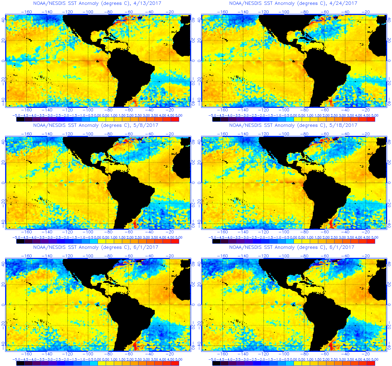
Nice graphic animation of how Nino 1+2 & Nino 3 has cooled over the past few weeks.

Image
1 likes   

SouthFloridian92
Tropical Storm
Tropical Storm
Posts: 120
Age: 32
Joined: Tue Dec 11, 2012 4:50 pm
Location: Sebring, Florida

Re: ENSO Updates

#8059 Postby SouthFloridian92 » Thu Jun 01, 2017 5:14 pm

Modoki...
0 likes   

User avatar
Kingarabian
S2K Supporter
S2K Supporter
Posts: 16024
Joined: Sat Aug 08, 2009 3:06 am
Location: Honolulu, Hawaii

Re: ENSO Updates

#8060 Postby Kingarabian » Thu Jun 01, 2017 5:27 pm

SouthFloridian92 wrote:Modoki...


Need la nina values at 1+2 for there to be a true Modoki event.
0 likes   
RIP Kobe Bryant


Return to “Talkin' Tropics”

Who is online

Users browsing this forum: Google Adsense [Bot], Kohlecane, LarryWx and 47 guests