2023 Indicators (SST, SAL, MSLP, Wind shear, Steering, Instability) and Day 16+ Models

This is the general tropical discussion area. Anyone can take their shot at predicting a storms path.

Moderator: S2k Moderators

Forum rules

The posts in this forum are NOT official forecasts and should not be used as such. They are just the opinion of the poster and may or may not be backed by sound meteorological data. They are NOT endorsed by any professional institution or STORM2K. For official information, please refer to products from the National Hurricane Center and National Weather Service.

Help Support Storm2K
Message
Author
User avatar
Jr0d
S2K Supporter
S2K Supporter
Posts: 1409
Joined: Tue Aug 27, 2019 10:52 am
Location: Cayo Hueso

Re: 2023 Indicators (SST, SAL, MSLP, Wind shear, Steering, Instability) and Day 16+ Models

#821 Postby Jr0d » Wed Jul 12, 2023 4:52 pm

LarryWx wrote:
Iceresistance wrote:Holy crap, and they said that this is NOT an error!

https://twitter.com/bhensonweather/status/1678177613284622337


Per the site noted below, Johnson Key, which is just off the S tip of the FL peninsula, hit 96.75F at 5PM on 7/10/23! I wonder how shallow the water is there. The morning water temp low, which was at 9AM, was 89.42F. So, the day's range was 7.33F, pretty wide for an offshore buoy's water temps. So, I assume it is quite shallow.

Johnson Key buoy data:
https://www.ndbc.noaa.gov/station_page. ... tion=jkyf1


I would guess that area got some heavy rain that cooled off the water. It is shallow so it doesn't take much.
0 likes   

LarryWx
S2K Supporter
S2K Supporter
Posts: 6310
Joined: Sun Sep 07, 2003 2:04 pm
Location: GA

Re: 2023 Indicators (SST, SAL, MSLP, Wind shear, Steering, Instability) and Day 16+ Models

#822 Postby LarryWx » Thu Jul 13, 2023 2:06 am

Jr0d wrote:
LarryWx wrote:
Iceresistance wrote:Holy crap, and they said that this is NOT an error!

https://twitter.com/bhensonweather/status/1678177613284622337


Per the site noted below, Johnson Key, which is just off the S tip of the FL peninsula, hit 96.75F at 5PM on 7/10/23! I wonder how shallow the water is there. The morning water temp low, which was at 9AM, was 89.42F. So, the day's range was 7.33F, pretty wide for an offshore buoy's water temps. So, I assume it is quite shallow.

Johnson Key buoy data:
https://www.ndbc.noaa.gov/station_page. ... tion=jkyf1


I would guess that area got some heavy rain that cooled off the water. It is shallow so it doesn't take much.


That makes sense. July 12th turned out to be the 3rd day in a row with ~97 for the hottest SST of the day at Johnson Key!
The 87 low at Key West on July 12th ties the record high low for any date back to 1873! Also, the mean temp of 90.5 turns out to be the hottest mean of any day back to 1873! The old record was 90.0, which was set on 8/4/2007.

 Marathon tied its alltime hottest mean of any on record, 92.0. The only other day on record with a mean this hot was 6/8/2019. This was the 32nd day this year and 8th day this month to date that Marathon beat or tied the daily record warm mean! Records go back to 1950.

This heat both on land and at sea has been insane both in the Keys and FL Bay this year!
3 likes   
Personal Forecast Disclaimer:
The posts in this forum are NOT official forecasts and should not be used as such. They are just the opinion of the poster and may or may not be backed by sound meteorological data. They are NOT endorsed by any professional institution or storm2k.org. For official information, please refer to the NHC and NWS products.

User avatar
Blown Away
S2K Supporter
S2K Supporter
Posts: 10147
Joined: Wed May 26, 2004 6:17 am

Re: 2023 Indicators (SST, SAL, MSLP, Wind shear, Steering, Instability) and Day 16+ Models

#823 Postby Blown Away » Thu Jul 13, 2023 6:33 am

July 13, 2022 the Atlantic was already at C storm with hype, excitement and projections of an active season and the D storm didn't happen until Sept 1... 2023 same situation and nothing in the GFS through July 29th... I know it's only July, but the models ATM are not picking up on even moderately favorable conditions over next few weeks... Cool thing is over the next 2 months we will learn if extreme SST's can overcome unfavorable moderate to strong El Nino conditions in the Atlantic to allow for an active season... I'm betting on El Nino, with one biggie that impacts somewhere in August... JMHO :D
1 likes   
Hurricane Eye Experience: David 79, Irene 99, Frances 04, Jeanne 04, Wilma 05... EYE COMING MY WAY IN 2024…
Hurricane Brush Experience: Andrew 92, Erin 95, Floyd 99, Matthew 16, Irma 17, Ian 22, Nicole 22…

User avatar
JetFuel_SE
Category 1
Category 1
Posts: 282
Age: 25
Joined: Thu Apr 30, 2020 3:57 pm

Re: 2023 Indicators (SST, SAL, MSLP, Wind shear, Steering, Instability) and Day 16+ Models

#824 Postby JetFuel_SE » Thu Jul 13, 2023 7:46 am

Blown Away wrote:July 13, 2022 the Atlantic was already at C storm with hype, excitement and projections of an active season and the D storm didn't happen until Sept 1... 2023 same situation and nothing in the GFS through July 29th... I know it's only July, but the models ATM are not picking up on even moderately favorable conditions over next few weeks... Cool thing is over the next 2 months we will learn if extreme SST's can overcome unfavorable moderate to strong El Nino conditions in the Atlantic to allow for an active season... I'm betting on El Nino, with one biggie that impacts somewhere in August... JMHO :D

Idk what GFS you're looking at, but the one I saw develops 94L and tries to develop two waves over the next two weeks.
Image
0 likes   

User avatar
Blown Away
S2K Supporter
S2K Supporter
Posts: 10147
Joined: Wed May 26, 2004 6:17 am

Re: 2023 Indicators (SST, SAL, MSLP, Wind shear, Steering, Instability) and Day 16+ Models

#825 Postby Blown Away » Thu Jul 13, 2023 7:58 am

JetFuel_SE wrote:
Blown Away wrote:July 13, 2022 the Atlantic was already at C storm with hype, excitement and projections of an active season and the D storm didn't happen until Sept 1... 2023 same situation and nothing in the GFS through July 29th... I know it's only July, but the models ATM are not picking up on even moderately favorable conditions over next few weeks... Cool thing is over the next 2 months we will learn if extreme SST's can overcome unfavorable moderate to strong El Nino conditions in the Atlantic to allow for an active season... I'm betting on El Nino, with one biggie that impacts somewhere in August... JMHO :D

Idk what GFS you're looking at, but the one I saw develops 94L and tries to develop two waves over the next two weeks.
https://cdn.discordapp.com/attachments/736018608366551111/1129031060185940019/49001251-05c9-4cb8-adf7-5b9db9889a4e.gif


I agree, 94L might be a weak TS/STS and a few weak low signatures on GFS over next 2 weeks, but looks very dry across the MDR, which is generally expected in July. Again, conditions IMO are at best marginally favorable per GFS through July.
0 likes   
Hurricane Eye Experience: David 79, Irene 99, Frances 04, Jeanne 04, Wilma 05... EYE COMING MY WAY IN 2024…
Hurricane Brush Experience: Andrew 92, Erin 95, Floyd 99, Matthew 16, Irma 17, Ian 22, Nicole 22…

User avatar
Category5Kaiju
Category 5
Category 5
Posts: 4098
Joined: Thu Dec 24, 2020 12:45 pm
Location: Seattle

Re: 2023 Indicators (SST, SAL, MSLP, Wind shear, Steering, Instability) and Day 16+ Models

#826 Postby Category5Kaiju » Thu Jul 13, 2023 8:39 am

Blown Away wrote:July 13, 2022 the Atlantic was already at C storm with hype, excitement and projections of an active season and the D storm didn't happen until Sept 1... 2023 same situation and nothing in the GFS through July 29th... I know it's only July, but the models ATM are not picking up on even moderately favorable conditions over next few weeks... Cool thing is over the next 2 months we will learn if extreme SST's can overcome unfavorable moderate to strong El Nino conditions in the Atlantic to allow for an active season... I'm betting on El Nino, with one biggie that impacts somewhere in August... JMHO :D


Last year in a way was a freak event, especially with the La Nina doing jack in allowing the Atlantic to be active from mid-July to the beginning of September. This year I feel will be different in that regard, and with there not being any abnormal subtropical/high latitude warmth like we saw last year that induced wave-breaking and frequent mid-level dry air intrusions, I think regardless of El Nino, there will likely be much more deep tropical instability. In other words, August may be a critical month to watch.
3 likes   
Unless explicitly stated, all info in my posts is based on my own opinions and observations. Tropical storms and hurricanes can be extremely dangerous. Do not think you can beat Mother Nature. Refer to an accredited weather research agency or meteorologist if you need to make serious decisions regarding an approaching storm.

LarryWx
S2K Supporter
S2K Supporter
Posts: 6310
Joined: Sun Sep 07, 2003 2:04 pm
Location: GA

Re: 2023 Indicators (SST, SAL, MSLP, Wind shear, Steering, Instability) and Day 16+ Models

#827 Postby LarryWx » Thu Jul 13, 2023 9:09 am

Category5Kaiju wrote:
Blown Away wrote:July 13, 2022 the Atlantic was already at C storm with hype, excitement and projections of an active season and the D storm didn't happen until Sept 1... 2023 same situation and nothing in the GFS through July 29th... I know it's only July, but the models ATM are not picking up on even moderately favorable conditions over next few weeks... Cool thing is over the next 2 months we will learn if extreme SST's can overcome unfavorable moderate to strong El Nino conditions in the Atlantic to allow for an active season... I'm betting on El Nino, with one biggie that impacts somewhere in August... JMHO :D


Last year in a way was a freak event, especially with the La Nina doing jack in allowing the Atlantic to be active from mid-July to the beginning of September. This year I feel will be different in that regard, and with there not being any abnormal subtropical/high latitude warmth like we saw last year that induced wave-breaking and frequent mid-level dry air intrusions, I think regardless of El Nino, there will likely be much more deep tropical instability. In other words, August may be a critical month to watch.


July is often a quiet month as we know. So, if it ends up quiet, that won't mean that much. August of 2023 will very likely be much more active in the MDR than the nearly dead August of 2022, which had dry AEW after dry AEW and no TC. It almost has to be more active than that. I'm predicting 3 named storms to form in August as of now, which is average for El Niño since 1995. I was tempted to predict only 2 NS for August due to the El Niño being moderate or stronger by then, but the very warm MDR told me to stick with 3 NS for now.
Last edited by LarryWx on Thu Jul 13, 2023 9:43 am, edited 1 time in total.
1 likes   
Personal Forecast Disclaimer:
The posts in this forum are NOT official forecasts and should not be used as such. They are just the opinion of the poster and may or may not be backed by sound meteorological data. They are NOT endorsed by any professional institution or storm2k.org. For official information, please refer to the NHC and NWS products.

User avatar
Jr0d
S2K Supporter
S2K Supporter
Posts: 1409
Joined: Tue Aug 27, 2019 10:52 am
Location: Cayo Hueso

Re: 2023 Indicators (SST, SAL, MSLP, Wind shear, Steering, Instability) and Day 16+ Models

#828 Postby Jr0d » Thu Jul 13, 2023 9:28 am

I am hoping the wave over Hispaniola deepens over the Fl. Keys/South Florida this weekend so we can get some rain relief and hopefully get the water to cool off a little. Unfortunately there is no model support. There is a decent chance the waves at 50W and 35W will eventually make it near S. Florida so hopefully they also can provide some relief.

All the nearshore water in the Keys is in the 90s right now, with some more stagnant shallow area seeing mid 90s. I am hoping for a weak sheared system in the next month to help cool off the water because with this much heat out there it wont take much for something to rapidly strengthen even in marginal conditions.

Seems like the long range climo maps are suggesting above average rain Greater Antilles and Florida through August suggesting that maybe that this could be a potential track of future waves or storms that potentially develop.

Unfortunately all is quiet, as it would be to get some weak systems cool off the water vs have all the heat sitting there if a long track system finds favorable conditions.

I dont think El Niño will do much to slow down the season through September except maybe hinder development of Cape Verde systems until the are closer or over the Lesser and Greater Antilles. This opinion is subject to change if the El Niño event is stronger than expected.
1 likes   

User avatar
ScottNAtlanta
Category 5
Category 5
Posts: 2367
Joined: Sat May 25, 2013 3:11 pm
Location: Atlanta, GA

Re: 2023 Indicators (SST, SAL, MSLP, Wind shear, Steering, Instability) and Day 16+ Models

#829 Postby ScottNAtlanta » Thu Jul 13, 2023 10:41 am

I've noticed that the SAL is already starting to pull north in its general seasonal shift that happens end of July beginning of August (what little SAL there has been this season). That should allow the waves coming off Africa to retain more moisture.
5 likes   
The posts in this forum are NOT official forecast and should not be used as such. They are just the opinion of the poster and may or may not be backed by sound meteorological data. They are NOT endorsed by any professional institution or storm2k.org. For official information, please refer to the NHC and NWS products.

LarryWx
S2K Supporter
S2K Supporter
Posts: 6310
Joined: Sun Sep 07, 2003 2:04 pm
Location: GA

Re: 2023 Indicators (SST, SAL, MSLP, Wind shear, Steering, Instability) and Day 16+ Models

#830 Postby LarryWx » Thu Jul 13, 2023 1:45 pm

Jr0d wrote:I am hoping the wave over Hispaniola deepens over the Fl. Keys/South Florida this weekend so we can get some rain relief and hopefully get the water to cool off a little. Unfortunately there is no model support. There is a decent chance the waves at 50W and 35W will eventually make it near S. Florida so hopefully they also can provide some relief.

All the nearshore water in the Keys is in the 90s right now, with some more stagnant shallow area seeing mid 90s. I am hoping for a weak sheared system in the next month to help cool off the water because with this much heat out there it wont take much for something to rapidly strengthen even in marginal conditions.

Seems like the long range climo maps are suggesting above average rain Greater Antilles and Florida through August suggesting that maybe that this could be a potential track of future waves or storms that potentially develop.

Unfortunately all is quiet, as it would be to get some weak systems cool off the water vs have all the heat sitting there if a long track system finds favorable conditions.

I dont think El Niño will do much to slow down the season through September except maybe hinder development of Cape Verde systems until the are closer or over the Lesser and Greater Antilles. This opinion is subject to change if the El Niño event is stronger than expected.


Marathon at 2PM is at 98 with a dewpoint of 80 producing a heat index of 118! That 98 is only one degree from their alltime hottest on record (back to 1950) of 99.
2 likes   
Personal Forecast Disclaimer:
The posts in this forum are NOT official forecasts and should not be used as such. They are just the opinion of the poster and may or may not be backed by sound meteorological data. They are NOT endorsed by any professional institution or storm2k.org. For official information, please refer to the NHC and NWS products.

User avatar
Jr0d
S2K Supporter
S2K Supporter
Posts: 1409
Joined: Tue Aug 27, 2019 10:52 am
Location: Cayo Hueso

Re: 2023 Indicators (SST, SAL, MSLP, Wind shear, Steering, Instability) and Day 16+ Models

#831 Postby Jr0d » Thu Jul 13, 2023 2:24 pm

LarryWx wrote:Marathon at 2PM is at 98 with a dewpoint of 80 producing a heat index of 118! That 98 is only one degree from their alltime hottest on record (back to 1950) of 99.


That gives a wet bulb temperature of almost 85°, dangerously close to extreme danger levels. There might be isolated areas that are even hotter than what the airport is measuring.

Im really hoping that wave over Haiti at least brings some rain this weekend but the models are only showing a slight increase of PoPs. We got a short lived thunderstorm in Key West yesterday evening and it was a great relief.

That said, I cant help but think of the 1935 storm, its small size and based on limited observations it went from a tropical storm over the Bahamas to cat 5 over the Keys. With water this hot, I am fearful of something spinning up incredibly fast if a storm can find a pocket of favorable weather.

Unfortunately the models aren't showing much in the next 2 weeks, so the water will contine to simmer. Hopefully if we do get storms, windshear and upper air conditions will be limiting factors.

Despite the now moderate El Niño forecast, most still expect an above average season. If increased shear prevents waves from developing and recurving in the MDR, then the SE CONUS may be at increased risk if those waves develop closer to home.
2 likes   

LarryWx
S2K Supporter
S2K Supporter
Posts: 6310
Joined: Sun Sep 07, 2003 2:04 pm
Location: GA

Re: 2023 Indicators (SST, SAL, MSLP, Wind shear, Steering, Instability) and Day 16+ Models

#832 Postby LarryWx » Thu Jul 13, 2023 4:43 pm

Jr0d wrote:
LarryWx wrote:Marathon at 2PM is at 98 with a dewpoint of 80 producing a heat index of 118! That 98 is only one degree from their alltime hottest on record (back to 1950) of 99.


That gives a wet bulb temperature of almost 85°, dangerously close to extreme danger levels. There might be isolated areas that are even hotter than what the airport is measuring.

Im really hoping that wave over Haiti at least brings some rain this weekend but the models are only showing a slight increase of PoPs. We got a short lived thunderstorm in Key West yesterday evening and it was a great relief.

That said, I cant help but think of the 1935 storm, its small size and based on limited observations it went from a tropical storm over the Bahamas to cat 5 over the Keys. With water this hot, I am fearful of something spinning up incredibly fast if a storm can find a pocket of favorable weather.

Unfortunately the models aren't showing much in the next 2 weeks, so the water will contine to simmer. Hopefully if we do get storms, windshear and upper air conditions will be limiting factors.

Despite the now moderate El Niño forecast, most still expect an above average season. If increased shear prevents waves from developing and recurving in the MDR, then the SE CONUS may be at increased risk if those waves develop closer to home.


..RECORD HIGH TEMPERATURE SET AT MARATHON TODAY

TODAY'S HIGH AT THE FLORIDA KEYS MARATHON INTERNATIONAL AIRPORT
REACHED 99 DEGREES FAHRENHEIT, SETTING A NEW DAILY HIGH TEMPERATURE
RECORD. THE PREVIOUS RECORD WAS 95 DEGREES, MOST RECENTLY SET IN
2022.

THIS TEMPERATURE ALSO TIES THE ALL-TIME RECORD HIGH FOR THE MARATHON
AREA, PREVIOUSLY SET ON JULY 15TH 1987 AND JUNE 17TH 1972.

TEMPERATURE RECORDS AT MARATHON DATE BACK TO JUNE 1950.
1 likes   
Personal Forecast Disclaimer:
The posts in this forum are NOT official forecasts and should not be used as such. They are just the opinion of the poster and may or may not be backed by sound meteorological data. They are NOT endorsed by any professional institution or storm2k.org. For official information, please refer to the NHC and NWS products.

User avatar
Ntxw
Storm2k Moderator
Storm2k Moderator
Posts: 22786
Joined: Wed Oct 21, 2009 6:34 pm
Location: DFW, Texas

Re: 2023 Indicators (SST, SAL, MSLP, Wind shear, Steering, Instability) and Day 16+ Models

#833 Postby Ntxw » Thu Jul 13, 2023 4:59 pm

LarryWx wrote:
Jr0d wrote:
LarryWx wrote:Marathon at 2PM is at 98 with a dewpoint of 80 producing a heat index of 118! That 98 is only one degree from their alltime hottest on record (back to 1950) of 99.


That gives a wet bulb temperature of almost 85°, dangerously close to extreme danger levels. There might be isolated areas that are even hotter than what the airport is measuring.

Im really hoping that wave over Haiti at least brings some rain this weekend but the models are only showing a slight increase of PoPs. We got a short lived thunderstorm in Key West yesterday evening and it was a great relief.

That said, I cant help but think of the 1935 storm, its small size and based on limited observations it went from a tropical storm over the Bahamas to cat 5 over the Keys. With water this hot, I am fearful of something spinning up incredibly fast if a storm can find a pocket of favorable weather.

Unfortunately the models aren't showing much in the next 2 weeks, so the water will contine to simmer. Hopefully if we do get storms, windshear and upper air conditions will be limiting factors.

Despite the now moderate El Niño forecast, most still expect an above average season. If increased shear prevents waves from developing and recurving in the MDR, then the SE CONUS may be at increased risk if those waves develop closer to home.


..RECORD HIGH TEMPERATURE SET AT MARATHON TODAY

TODAY'S HIGH AT THE FLORIDA KEYS MARATHON INTERNATIONAL AIRPORT
REACHED 99 DEGREES FAHRENHEIT, SETTING A NEW DAILY HIGH TEMPERATURE
RECORD. THE PREVIOUS RECORD WAS 95 DEGREES, MOST RECENTLY SET IN
2022.

THIS TEMPERATURE ALSO TIES THE ALL-TIME RECORD HIGH FOR THE MARATHON
AREA, PREVIOUSLY SET ON JULY 15TH 1987 AND JUNE 17TH 1972.

TEMPERATURE RECORDS AT MARATHON DATE BACK TO JUNE 1950.


There seems to be recurring theme of these records from 1972 and 1987..
2 likes   
The above post and any post by Ntxw is NOT an official forecast and should not be used as such. It is just the opinion of the poster and may or may not be backed by sound meteorological data. It is NOT endorsed by any professional institution including Storm2k. For official information, please refer to NWS products.

  Help support Storm2K!
Help Support Storm2K

User avatar
ScottNAtlanta
Category 5
Category 5
Posts: 2367
Joined: Sat May 25, 2013 3:11 pm
Location: Atlanta, GA

Re: 2023 Indicators (SST, SAL, MSLP, Wind shear, Steering, Instability) and Day 16+ Models

#834 Postby ScottNAtlanta » Thu Jul 13, 2023 5:35 pm

I dont recall whether it is a wetbulb of 80 or 85 but at one of those temperatures you should avoid being outside for more than 15-20 mins. At those dewpoints it is impossible for your body's cooling system to function and you can get quite ill very quickly
0 likes   
The posts in this forum are NOT official forecast and should not be used as such. They are just the opinion of the poster and may or may not be backed by sound meteorological data. They are NOT endorsed by any professional institution or storm2k.org. For official information, please refer to the NHC and NWS products.

User avatar
gatorcane
S2K Supporter
S2K Supporter
Posts: 23691
Age: 47
Joined: Sun Mar 13, 2005 3:54 pm
Location: Boca Raton, FL

Re: 2023 Indicators (SST, SAL, MSLP, Wind shear, Steering, Instability) and Day 16+ Models

#835 Postby gatorcane » Thu Jul 13, 2023 8:34 pm

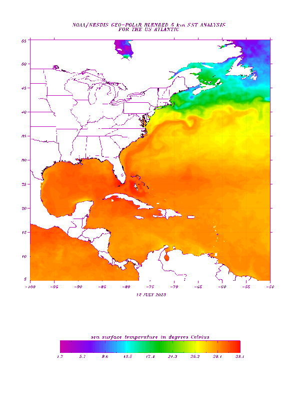
Some of the warmest SSTs anomalies in the Atlantic are around Southern Florida and into the Bahamas currently which I think we can contribute to an overall lack of Bermuda High influence (for the most part) and lack of “easterlies” across the region this summer so far which, in part, may be due to a building El Niño impacting the long-wave pattern across North America. Winds have been light and variable or even with a westerly component:

Image
1 likes   

User avatar
Jr0d
S2K Supporter
S2K Supporter
Posts: 1409
Joined: Tue Aug 27, 2019 10:52 am
Location: Cayo Hueso

Re: 2023 Indicators (SST, SAL, MSLP, Wind shear, Steering, Instability) and Day 16+ Models

#836 Postby Jr0d » Thu Jul 13, 2023 10:18 pm

ScottNAtlanta wrote:I dont recall whether it is a wetbulb of 80 or 85 but at one of those temperatures you should avoid being outside for more than 15-20 mins. At those dewpoints it is impossible for your body's cooling system to function and you can get quite ill very quickly

I think its 30°C 86°F is the "danger zone". It might be over 90°F where it can be deadly in less than an hour... regardless it unbearable out therr.

That said its dangerously close number and its possible isolated area have reached it.

A little off topic but hoping we get something to cool the water off before the heart of hurricane season.
0 likes   

User avatar
JetFuel_SE
Category 1
Category 1
Posts: 282
Age: 25
Joined: Thu Apr 30, 2020 3:57 pm

Re: 2023 Indicators (SST, SAL, MSLP, Wind shear, Steering, Instability) and Day 16+ Models

#837 Postby JetFuel_SE » Fri Jul 14, 2023 12:33 am

Jr0d wrote:
ScottNAtlanta wrote:I dont recall whether it is a wetbulb of 80 or 85 but at one of those temperatures you should avoid being outside for more than 15-20 mins. At those dewpoints it is impossible for your body's cooling system to function and you can get quite ill very quickly

I think its 30°C 86°F is the "danger zone". It might be over 90°F where it can be deadly in less than an hour... regardless it unbearable out therr.

That said its dangerously close number and its possible isolated area have reached it.

A little off topic but hoping we get something to cool the water off before the heart of hurricane season.

That thing to cool the water could end up being a strong cane.
0 likes   

LarryWx
S2K Supporter
S2K Supporter
Posts: 6310
Joined: Sun Sep 07, 2003 2:04 pm
Location: GA

Re: 2023 Indicators (SST, SAL, MSLP, Wind shear, Steering, Instability) and Day 16+ Models

#838 Postby LarryWx » Fri Jul 14, 2023 7:05 am

As already said, Key West had a new alltime record high mean temp on 7/12. Yesterday 7/13, Marathon did the same with a mean of 92.5 (alltime record high tied at 99 and daily record high low of 86). I think the peak of the heat has now finally passed due to increased clouds/shower chances.
Last edited by LarryWx on Fri Jul 14, 2023 7:18 am, edited 1 time in total.
1 likes   
Personal Forecast Disclaimer:
The posts in this forum are NOT official forecasts and should not be used as such. They are just the opinion of the poster and may or may not be backed by sound meteorological data. They are NOT endorsed by any professional institution or storm2k.org. For official information, please refer to the NHC and NWS products.

LarryWx
S2K Supporter
S2K Supporter
Posts: 6310
Joined: Sun Sep 07, 2003 2:04 pm
Location: GA

Re: 2023 Indicators (SST, SAL, MSLP, Wind shear, Steering, Instability) and Day 16+ Models

#839 Postby LarryWx » Fri Jul 14, 2023 7:17 am

JetFuel_SE wrote:
Jr0d wrote:
ScottNAtlanta wrote:I dont recall whether it is a wetbulb of 80 or 85 but at one of those temperatures you should avoid being outside for more than 15-20 mins. At those dewpoints it is impossible for your body's cooling system to function and you can get quite ill very quickly

I think its 30°C 86°F is the "danger zone". It might be over 90°F where it can be deadly in less than an hour... regardless it unbearable out therr.

That said its dangerously close number and its possible isolated area have reached it.

A little off topic but hoping we get something to cool the water off before the heart of hurricane season.

That thing to cool the water could end up being a strong cane.


Now that shower activity have finally picked up since yesterday, I've finally noticed a significant cooling of the water at Johnson Key buoy this morning with it down to 88.3 F as of 7AM with it still falling. Not that that's "cool", but it is quite a bit lower than yesterday's morning SST low (at 11 AM) of 91.6 based on hourlies and is the coolest low in at least five days (7/10-13 lows were 89.5-91.6). This shows how easy it was to cool this very shallow (5') water back down significantly after being so incredibly hot. All it took was increased shower activity following a very sunny and dry period associated with a significant SAL.

https://www.ndbc.noaa.gov/station_page. ... tion=jkyf1

Edit for update: lowest SST today through 10AM was 9AM's 87.8F, which is 3.8F lower than yesterday's low.

Edit for 2nd update: highest SST today only 93.9 vs upper 90s last 4+ days
Last edited by LarryWx on Fri Jul 14, 2023 10:05 pm, edited 2 times in total.
1 likes   
Personal Forecast Disclaimer:
The posts in this forum are NOT official forecasts and should not be used as such. They are just the opinion of the poster and may or may not be backed by sound meteorological data. They are NOT endorsed by any professional institution or storm2k.org. For official information, please refer to the NHC and NWS products.

User avatar
Category5Kaiju
Category 5
Category 5
Posts: 4098
Joined: Thu Dec 24, 2020 12:45 pm
Location: Seattle

Re: 2023 Indicators (SST, SAL, MSLP, Wind shear, Steering, Instability) and Day 16+ Models

#840 Postby Category5Kaiju » Fri Jul 14, 2023 8:12 am

We already have the D storm. Bye 2022! :lol:
3 likes   
Unless explicitly stated, all info in my posts is based on my own opinions and observations. Tropical storms and hurricanes can be extremely dangerous. Do not think you can beat Mother Nature. Refer to an accredited weather research agency or meteorologist if you need to make serious decisions regarding an approaching storm.


Return to “Talkin' Tropics”

Who is online

Users browsing this forum: sasha_B and 45 guests