Seasonal Indicators (Beyond Day 16): Instability / SST's / MSLP / Steering / Sal

This is the general tropical discussion area. Anyone can take their shot at predicting a storms path.

Moderator: S2k Moderators

Forum rules

The posts in this forum are NOT official forecasts and should not be used as such. They are just the opinion of the poster and may or may not be backed by sound meteorological data. They are NOT endorsed by any professional institution or STORM2K. For official information, please refer to products from the National Hurricane Center and National Weather Service.

Help Support Storm2K
Message
Author
TheStormExpert

Re: Seasonal Indicators (Beyond Day 15): Instability / SST's / MSLP / Steering / Sal

#841 Postby TheStormExpert » Wed Jul 06, 2016 9:33 pm

Hurricaneman wrote:I look at 1998 and what I see for the most part is a dusty dry atlantic until mid August and things changed just like that to an active regime in the MDR which included such storms as Bonnie, Danielle, Georges, Ivan, Jeanne into late September so in that time between August19 to September 25 there were 5 storms that formed in the MDR so if this year is anything like 1998 we could get 1 month of craziness starting next month or if the models are right could be even late this month

The posts in this forum are NOT official forecast and should not be used as such. They are just the opinion of the poster and may or may not be backed by sound meteorological data. They are NOT endorsed by any professional institution or STORM2K. For official information, please refer to products from the National Hurricane Center and National Weather Service

Another good analog in my opinion of a season that had 6-8 weeks of CRAZINESS with storm after storm is 2004, though the overall steering pattern seems quite different this year.
0 likes   

User avatar
Steve
S2K Supporter
S2K Supporter
Posts: 9621
Joined: Sat Apr 05, 2003 11:41 pm
Location: Not a state-caster

Re: Seasonal Indicators (Beyond Day 15): Instability / SST's / MSLP / Steering / Sal

#842 Postby Steve » Wed Jul 06, 2016 9:36 pm

1998 also featured Frances. I've mentioned that before but we were having a baby shower at work and it was raining buckets. I put the small tv on and Bob Breck was showing training bands setting up. It ended up flooding, and I got stuck on a neutral ground for 3-4 hours. Haha. Now if there is a disorganized storm off Brownsville, I pay attention. But that year was different. I seem to remember it was ultra, ultra dry and hot here. I'm not sure about overall, but it was drought in the summer. George hit 100+ miles east of here but all the broken tree limbs knocked power out across the city of N.O. The wasps that summer were everywhere. My kids and their friends took up wasping with tennis rackets that summer. Haha. They always have more of them when it's hot and dry. A lot of the patterns are similar except I think Joe B pointed out yesterday or today that this year's La Niña is and will fall at a slower rate. I think the SSTA's bear that out some with only the thin blue squiggly tongue for now. I forgot about Hermine that year too. It hit before Georges. We were down in the Rigolets (R.I.P.) and it was only breezy with all the weather Mobile Bay and eastward. That's a few North Gulf impacts and only slightly less for me (#3 I think) than the number of storms affected by in a season which would be 2002 and 2005.

If we do end up with some Gulf similarities to 1998, minor changes in patterns and slight deviations of a hundred miles or two with some of the mid and upper features will make a difference. I think the threat is slightly east of 1998's Gulf season, but that's just me.
0 likes   

User avatar
Hurricaneman
Category 5
Category 5
Posts: 7351
Age: 45
Joined: Tue Aug 31, 2004 3:24 pm
Location: central florida

Re: Seasonal Indicators (Beyond Day 15): Instability / SST's / MSLP / Steering / Sal

#843 Postby Hurricaneman » Wed Jul 06, 2016 9:43 pm

Also you can't discount any wave unless there is clearly shear in its path, look at 2004 Charley for example or even Katrina in 2005 in both cases the wave while in the MDR barely had convection in both cases and by the time Charley got to near the Caribbean it began to develop or in Katrina's case got near the Bahamas before developing so I'm thinking we may have a few of those type systems this year where the wave doesn't do much and then BAM we get a major hurricane farther west

The posts in this forum are NOT official forecast and should not be used as such. They are just the opinion of the poster and may or may not be backed by sound meteorological data. They are NOT endorsed by any professional institution or STORM2K. For official information, please refer to products from the National Hurricane Center and National Weather Service
0 likes   

User avatar
Andrew92
S2K Supporter
S2K Supporter
Posts: 3247
Age: 41
Joined: Mon Jun 16, 2003 12:35 am
Location: Phoenix, Arizona

Re: Seasonal Indicators (Beyond Day 15): Instability / SST's / MSLP / Steering / Sal

#844 Postby Andrew92 » Wed Jul 06, 2016 10:21 pm

It's been a while since I've posted, and I think a week in July is fine time for an evaluation of the season to date, plus analog discussion.

I see what some are saying about 1998. La Nina was delayed from really making its appearance that year until closer to the peak of the season. Indeed, while we have seen three more storms (I'm excluding Alex here as more of a 2015-ish storm) than we had in 1998 by this point, all were weak and short-lived.

However, I am going to sound like a broken record going back to older posts. I am still seeing a 1959-like setup. That year was seeing its fourth storm form (Cindy) just off the East Coast at about this time, with one very sketchy hurricane having already occurred (the unnamed storm, which I have seen speculation may be downgraded to a tropical storm, but still have hurricane-force winds after becoming extratropical). If you look at that paths of those four storms, including Cindy, and compare with this year's so far, there are some jarring comparisons. Colin was probably similar to the unnamed storm, though weaker. Danielle was also very similar to Beulah. Timing is off on both comparisons, though Danielle and Beulah only by a couple days. Bonnie was similar in track to Cindy as well, though two months earlier and weaker (though Cindy may be downgraded to a tropical storm. I have seen such speculation, so stay tuned.) We haven't seen anything really resembling Arlene from that year yet, though. Still, pretty decent Atlantic comparisons overall.

That said, the WPAC had much more activity by this time in 1959. The EPAC also hadn't had a major hurricane yet, only producing a couple tropical storms. And here we are now tracking monster Blas, and our first named storm in the WPAC, Nepartak. So maybe another analog like 1998 is worth another look all the same, and 1959 is weakening a tad. 1998, like this year, had a slow WPAC to start, finally getting the first storm in July as well. And the EPAC already had its first major, ironically also named Blas! So maybe I should have more open of a mind to that year as well as 1959.

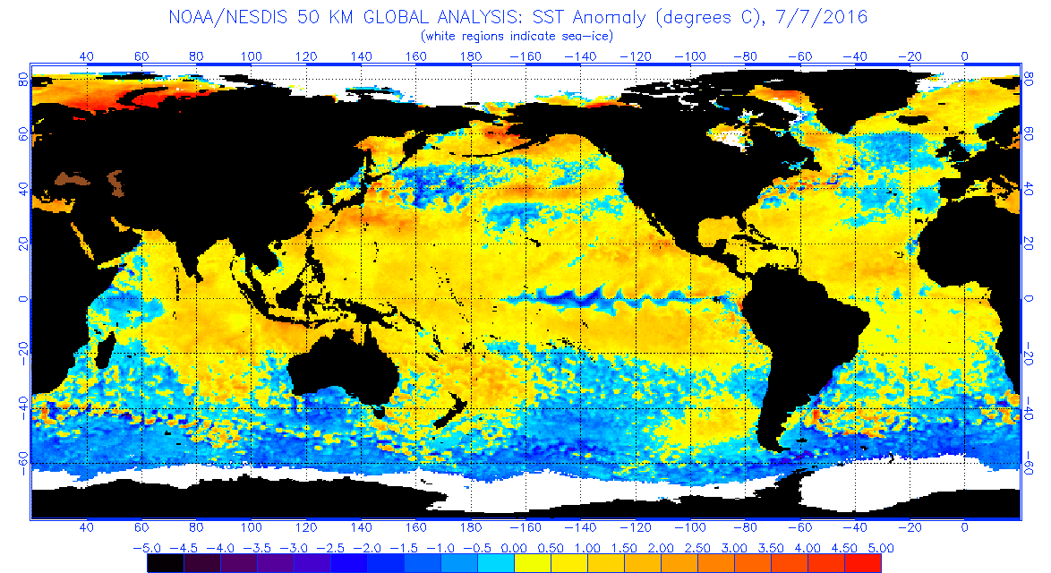
I just can't give up on that warm EPAC MDR though! It never fizzled in 1959, but I believe it did in 1998. We'll see in the coming weeks and months what transpires with that area.

-Andrew92
0 likes   

User avatar
Yellow Evan
Professional-Met
Professional-Met
Posts: 16143
Age: 27
Joined: Fri Jul 15, 2011 12:48 pm
Location: Henderson, Nevada/Honolulu, HI
Contact:

Re: Seasonal Indicators (Beyond Day 15): Instability / SST's / MSLP / Steering / Sal

#845 Postby Yellow Evan » Wed Jul 06, 2016 10:25 pm

Worth pointing out that records in the WPAC/EPAC in 1959 are not reliable at all. In the WPAC's case, storms were overestimates, but in the EPAC cases, storms were mostly either 25, 45, or 75 knots in HURDAT (not realistic at all).
0 likes   

User avatar
Andrew92
S2K Supporter
S2K Supporter
Posts: 3247
Age: 41
Joined: Mon Jun 16, 2003 12:35 am
Location: Phoenix, Arizona

Re: Seasonal Indicators (Beyond Day 15): Instability / SST's / MSLP / Steering / Sal

#846 Postby Andrew92 » Wed Jul 06, 2016 10:31 pm

Yellow Evan wrote:Worth pointing out that records in the WPAC/EPAC in 1959 are not reliable at all. In the WPAC's case, storms were overestimates, but in the EPAC cases, storms were mostly either 25, 45, or 75 knots in HURDAT (not realistic at all).


Excellent point. However, there was allegedly a powerful typhoon in April of that year, so I have to believe there was something out there. Then again, everything else was supposedly tropical storms. My gut also tells me that maybe one of the two known EPAC storms could have been a hurricane, but I have some doubts the data is so unreliable that a major was left out. Man, I would love to know for sure though!

One of those first 1959 EPAC storms made landfall too. We haven't seen that yet, nor had we in 1998.

-Andrew92
0 likes   

User avatar
hurricanetrack
HurricaneTrack.com
HurricaneTrack.com
Posts: 1781
Joined: Tue Dec 02, 2003 10:46 pm
Location: Wilmington, NC
Contact:

Re: Seasonal Indicators (Beyond Day 15): Instability / SST's / MSLP / Steering / Sal

#847 Postby hurricanetrack » Thu Jul 07, 2016 1:06 pm

So - now that it is early July, any word from our pro mets who have access to the full ECMWF product suite as to what ASO looks like tropics-wise? Almost forgot about the monthly updates that come out around now. Still showing the same thing? More? Less?
1 likes   

User avatar
weathaguyry
Category 5
Category 5
Posts: 1272
Age: 22
Joined: Wed Jun 15, 2016 5:16 am
Location: Long Island, NY

Re: Seasonal Indicators (Beyond Day 15): Instability / SST's / MSLP / Steering / Sal

#848 Postby weathaguyry » Thu Jul 07, 2016 5:35 pm

This came out today, looks like things are starting to get pretty cold between 130 and 150 degrees west...

Image
1 likes   
My posts are only my opinions and NOT official forecasts. For official forecasts, consult the National Hurricane Center or the National Weather Service.

Irene 11', Sandy 12', Fay 20’, Isaias 20’, Elsa 21’, Henri 21’, Ida 21’

User avatar
gatorcane
S2K Supporter
S2K Supporter
Posts: 23691
Age: 47
Joined: Sun Mar 13, 2005 3:54 pm
Location: Boca Raton, FL

Re: Seasonal Indicators (Beyond Day 15): Instability / SST's / MSLP / Steering / Sal

#849 Postby gatorcane » Thu Jul 07, 2016 8:31 pm

Hammy wrote: The similarities to 1998 continue to be remarkable. El Nino exiting, drought in the southeast, repeated troughs coming off the Mid-Atlantic and Northeast coast, and large dry swath across most of the Atlantic.
http://i.imgur.com/v420fqU.jpg today (there is more convection than the visible image leads one to believe.)
http://i.imgur.com/tIxtHRh.png 7/18/98: very similar appearance to now, and this was later in the month even. And Florida went most of June and though a large chunk of July with little to no rainfall.

But 1999-2001 also had long dry periods during July.
http://i.imgur.com/5UeVezj.png July 25 1999
http://i.imgur.com/sOx1Upt.png July 24 2000
http://i.imgur.com/Wirr1xy.png July 19 2001 (later in the month and the western section of the ITCZ was all but nonexistent.)

All three largely mirror this season: some ITCZ convection, convection north of the Caribbean, east coast trough, and basically nothing in the Caribbean or GoM.

In fact there was one depression in July, in the BoC, that formed as it was moving inland during those three years. A barren July in the Atlantic is no indicator of the rest of the season, and if anything the convection is higher overall so far this year during July than it's been since 2012.


Hammy this is some good research and it shows that July can indeed be bone-dry across the Atlantic, even so you are right it is more moist this year than it was than in those years you posted which turned out quite active. In fact the tropical wave out around 40W has flared up quite a bit the past few days.

Another thing that some folks have pointed out in this thread is that shear quite a bit more favorable this year than last year. I pulled up a shear tendency map from CIMSS and even during the heart of the season last year, it did not look this favorable so we can only imagine that by August, it will look even better than this.

Image
0 likes   

Alyono
Professional-Met
Professional-Met
Posts: 6961
Joined: Fri Apr 26, 2013 3:52 pm
Location: Texas Coast

Re: Seasonal Indicators (Beyond Day 15): Instability / SST's / MSLP / Steering / Sal

#850 Postby Alyono » Thu Jul 07, 2016 8:40 pm

hurricanetrack wrote:So - now that it is early July, any word from our pro mets who have access to the full ECMWF product suite as to what ASO looks like tropics-wise? Almost forgot about the monthly updates that come out around now. Still showing the same thing? More? Less?


The charts are not yet available
1 likes   

ninel conde

Re: Seasonal Indicators (Beyond Day 15): Instability / SST's / MSLP / Steering / Sal

#851 Postby ninel conde » Thu Jul 07, 2016 10:14 pm

Looks to me dan leonard is going to be wrong about the ridge expanding north. No change in the wnw flow and flood pattern.
0 likes   

User avatar
Hurricaneman
Category 5
Category 5
Posts: 7351
Age: 45
Joined: Tue Aug 31, 2004 3:24 pm
Location: central florida

Re: Seasonal Indicators (Beyond Day 15): Instability / SST's / MSLP / Steering / Sal

#852 Postby Hurricaneman » Thu Jul 07, 2016 10:25 pm

What I'm seeing indicates that indeed late this month or early August will probably when we see Earl but thats a total guess but the Euro's readings of the MJO seem to indicate this may be possible and a NW shift of the Azores\Bermuda high in the models

The posts in this forum are NOT official forecast and should not be used as such. They are just the opinion of the poster and may or may not be backed by sound meteorological data. They are NOT endorsed by any professional institution or STORM2K. For official information, please refer to products from the National Hurricane Center and National Weather Service
0 likes   

ninel conde

Re: Seasonal Indicators (Beyond Day 15): Instability / SST's / MSLP / Steering / Sal

#853 Postby ninel conde » Thu Jul 07, 2016 11:05 pm

Image

I see no sign of a pattern change. The ridge is NOT expanding north and instead the wnw flow continues unabated and the se canada low has taken on monstrous proportions. very winterlike. I sense some grasping at straws for an active season. Just dont see it notwithstanding long range models insisting it will change.
0 likes   

User avatar
Hammy
Category 5
Category 5
Posts: 5849
Age: 41
Joined: Fri May 25, 2012 5:25 pm
Contact:

Re: Seasonal Indicators (Beyond Day 15): Instability / SST's / MSLP / Steering / Sal

#854 Postby Hammy » Fri Jul 08, 2016 12:18 am

ninel conde wrote:I see no sign of a pattern change. The ridge is NOT expanding north and instead the wnw flow continues unabated and the se canada low has taken on monstrous proportions. very winterlike. I sense some grasping at straws for an active season. Just dont see it notwithstanding long range models insisting it will change.


The pattern is not going to suddenly change over a six day period--it's going to likely be gradual. And as far as the high, it's already showing signs of changing, as before (I recall an earlier map you posted) showed the high much further south. Where it's at, were something to forum immediately it would be steered into Texas, whereas before it would've buried in Central America. It's not 'moving north' per se, but seems to be shrinking eastward slightly.
1 likes   
The above post is not official and should not be used as such. It is the opinion of the poster and may or may not be backed by sound meteorological data. It is not endorsed by any professional institution or storm2k.org. For official information, please refer to the NHC and NWS products.

stormwise

Re: Seasonal Indicators (Beyond Day 15): Instability / SST's / MSLP / Steering / Sal

#855 Postby stormwise » Fri Jul 08, 2016 5:27 am

Image

Image
0 likes   

ninel conde

Re: Seasonal Indicators (Beyond Day 15): Instability / SST's / MSLP / Steering / Sal

#856 Postby ninel conde » Fri Jul 08, 2016 5:44 am

stormwise wrote:Image

Image


interesting, but day 18 is a bit far out, and day 44 is far from a certainty. I keep looking at the 10 day for trends.
0 likes   

stormwise

Re: Seasonal Indicators (Beyond Day 15): Instability / SST's / MSLP / Steering / Sal

#857 Postby stormwise » Fri Jul 08, 2016 6:03 am

I posted them for you to be used as a paradigm ninel.
0 likes   

ninel conde

Re: Seasonal Indicators (Beyond Day 15): Instability / SST's / MSLP / Steering / Sal

#858 Postby ninel conde » Fri Jul 08, 2016 6:16 am

stormwise wrote:I posted them for you to be used as a paradigm ninel.


thanks!!
0 likes   

tolakram
Admin
Admin
Posts: 20009
Age: 62
Joined: Sun Aug 27, 2006 8:23 pm
Location: Florence, KY (name is Mark)

Re: Seasonal Indicators (Beyond Day 15): Instability / SST's / MSLP / Steering / Sal

#859 Postby tolakram » Fri Jul 08, 2016 7:05 am

We have two threads, the model thread for 15 days and under and this thread for longer term pattern discussions. If posting shorter term models please use the other thread here -> viewtopic.php?f=31&t=117742&start=660

Thanks.
0 likes   
M a r k
- - - - -
Join us in chat: Storm2K Chatroom Invite. Android and IOS apps also available.

The posts in this forum are NOT official forecasts and should not be used as such. Posts are NOT endorsed by any professional institution or STORM2K.org. For official information and forecasts, please refer to NHC and NWS products.

tolakram
Admin
Admin
Posts: 20009
Age: 62
Joined: Sun Aug 27, 2006 8:23 pm
Location: Florence, KY (name is Mark)

Re: Seasonal Indicators (Beyond Day 15): Instability / SST's / MSLP / Steering / Sal

#860 Postby tolakram » Fri Jul 08, 2016 7:11 am

Looking at the probability page, most indicators are much more positive this year.

http://rammb.cira.colostate.edu/project ... _00-24.asp

Tropical Atlantic instability is still below normal, but better than previous years, and shear is near or below normal in all regions. MSLP is above normal in the Tropical Atlantic and Caribbean.
0 likes   
M a r k
- - - - -
Join us in chat: Storm2K Chatroom Invite. Android and IOS apps also available.

The posts in this forum are NOT official forecasts and should not be used as such. Posts are NOT endorsed by any professional institution or STORM2K.org. For official information and forecasts, please refer to NHC and NWS products.


Return to “Talkin' Tropics”

Who is online

Users browsing this forum: LarryWx, riapal, Stormlover70, Zeta and 45 guests