Thoughts on 2013 Atlantic Hurricane Season

This is the general tropical discussion area. Anyone can take their shot at predicting a storms path.

Moderator: S2k Moderators

Forum rules

The posts in this forum are NOT official forecasts and should not be used as such. They are just the opinion of the poster and may or may not be backed by sound meteorological data. They are NOT endorsed by any professional institution or STORM2K. For official information, please refer to products from the National Hurricane Center and National Weather Service.

Help Support Storm2K
Message
Author
User avatar
blp
Category 5
Category 5
Posts: 2840
Age: 46
Joined: Thu Sep 09, 2004 7:51 pm
Location: Miami, FL
Contact:

Re: Thoughts on activity as heart of season nears

#881 Postby blp » Mon Sep 09, 2013 3:59 pm

Extratropical94 wrote:The report says [...]Gustav became the 2002 season's first hurricane just before 1200 UTC[...]

So we have 39 hours left.

Timer :darrow:
http://www.timeanddate.com/countdown/ge ... +Hurricane


That is awesome... Thanks for sharing. It feels like New Years in September. :lol:
0 likes   
The following post is NOT an official forecast and should not be used as such. It is just the opinion of the poster and may or may not be backed by sound meteorological data. It is NOT endorsed by any professional institution including storm2k.org For Official Information please refer to the NHC and NWS products.

Stormcenter
S2K Supporter
S2K Supporter
Posts: 6684
Joined: Wed Sep 03, 2003 11:27 am
Location: Houston, TX

#882 Postby Stormcenter » Mon Sep 09, 2013 4:12 pm

This is from the NWS in New Orleans.....I'm really starting to doubt we along the Gulf Coast will have any "serious" issues to deal with from the tropics this season. Everyday that goes by now that we are headed toward mid Sept. adds to the odds against it IMO.

AREA FORECAST DISCUSSION
NATIONAL WEATHER SERVICE NEW ORLEANS LA
353 PM CDT MON SEP 9 2013


.LONG TERM...
HIGH PRESSURE AREA BREAKS DOWN ENOUGH TO ALLOW A CANADIAN FRONT TO
ADVANCE SOUTHWARD ON DIGGING UPPER TROUGH IMPETUS OVER THE EASTERN
U.S. THE FRONT SHOULD APPROACH WITH A BACK-DOOR ORIENTATION
SATURDAY...WHICH IS TYPICALLY DEVOID OF TOO MUCH CONVECTION BUT
MAY ENHANCE THE FEW STORMS A BIT DUE TO COMPRESSIONAL HEATING AND
FRONTAL FORCING. TEMPERATURES WILL REMAIN WARMER THAN NORMAL
THROUGH SATUDAY THEN COOL TO NEAR NORMAL LEVELS FOR MID-SEPTEMBER
SUNDAY AND MONDAY. MEANWHILE...TELECONNECTIONS WOULD STRONGLY
FAVOR LOW PRESSURE DEVELOPMENT IN THE SOUTHWEST GULF OF MEXICO.
THE GLOBAL MODELS AGREE WITH THIS NOTION WITH SOME INDICATIONS OF
POTENTIAL TROPICAL CYCLONE DEVELOPMENTS THIS WEEKEND. ANY
DEVELOPMENT TRACKS WOULD FAVOR A WESTWARD MOTION INTO MEXICO...AS
SEVERAL OTHER SYSTEMS HAVE DONE THIS SEASON ALREADY. CURRENT
STRONG WESTERLY SHEAR WOULD HAVE TO ABATE ACROSS THE LOWER GULF
BEFORE ANY DEVELOPMENT TAKES PLACE...BUT SHEAR SHOULD LESSEN IN
TIME. 24/RR
0 likes   

User avatar
Hurricane_Luis
Category 2
Category 2
Posts: 723
Age: 27
Joined: Sat Jun 23, 2012 3:14 pm
Location: Tiptree, Essex, United Kingdom
Contact:

Re: Thoughts on activity as heart of season nears

#883 Postby Hurricane_Luis » Mon Sep 09, 2013 4:54 pm

Countdown to record: 1 day 10 hours 5 minutes 45 seconds (As of 10:52 UTC 9/9/13)
0 likes   

CYCLONE MIKE
Category 5
Category 5
Posts: 2183
Joined: Tue Aug 31, 2004 6:04 pm
Location: Gonzales, LA

Re:

#884 Postby CYCLONE MIKE » Mon Sep 09, 2013 5:34 pm

Stormcenter wrote:This is from the NWS in New Orleans.....I'm really starting to doubt we along the Gulf Coast will have any "serious" issues to deal with from the tropics this season. Everyday that goes by now that we are headed toward mid Sept. adds to the odds against it IMO.

AREA FORECAST DISCUSSION
NATIONAL WEATHER SERVICE NEW ORLEANS LA
353 PM CDT MON SEP 9 2013


.LONG TERM...
HIGH PRESSURE AREA BREAKS DOWN ENOUGH TO ALLOW A CANADIAN FRONT TO
ADVANCE SOUTHWARD ON DIGGING UPPER TROUGH IMPETUS OVER THE EASTERN
U.S. THE FRONT SHOULD APPROACH WITH A BACK-DOOR ORIENTATION
SATURDAY...WHICH IS TYPICALLY DEVOID OF TOO MUCH CONVECTION BUT
MAY ENHANCE THE FEW STORMS A BIT DUE TO COMPRESSIONAL HEATING AND
FRONTAL FORCING. TEMPERATURES WILL REMAIN WARMER THAN NORMAL
THROUGH SATUDAY THEN COOL TO NEAR NORMAL LEVELS FOR MID-SEPTEMBER
SUNDAY AND MONDAY. MEANWHILE...TELECONNECTIONS WOULD STRONGLY
FAVOR LOW PRESSURE DEVELOPMENT IN THE SOUTHWEST GULF OF MEXICO.
THE GLOBAL MODELS AGREE WITH THIS NOTION WITH SOME INDICATIONS OF
POTENTIAL TROPICAL CYCLONE DEVELOPMENTS THIS WEEKEND. ANY
DEVELOPMENT TRACKS WOULD FAVOR A WESTWARD MOTION INTO MEXICO...AS
SEVERAL OTHER SYSTEMS HAVE DONE THIS SEASON ALREADY. CURRENT
STRONG WESTERLY SHEAR WOULD HAVE TO ABATE ACROSS THE LOWER GULF
BEFORE ANY DEVELOPMENT TAKES PLACE...BUT SHEAR SHOULD LESSEN IN
TIME. 24/RR


I agree stormcenter. Either high will dominate and send stuff to mexico or will have a front draped across the gulf creating tons of shear and send them to Florida, sorry guys. Just seems there is no middle ground this year, one extreme or the other.
0 likes   
This post is NOT AN OFFICIAL FORECAST and should not be used as such. It is just the opinion of the poster and may or may not be backed by sound meteorological data. It is NOT endorsed by any professional institution including storm2k.org. For Official Information please refer to the NHC and NWS products.

User avatar
Portastorm
Storm2k Moderator
Storm2k Moderator
Posts: 9914
Age: 63
Joined: Fri Jul 11, 2003 9:16 am
Location: Round Rock, TX
Contact:

Re: Thoughts on activity as heart of season nears

#885 Postby Portastorm » Mon Sep 09, 2013 5:49 pm

No need to say you're sorry, Cyclone Mike ... unless, of course, your opinion proves to be right. At that point, we Texans will hold you personally responsible for continuing our drought! :lol:

For the record, I hope the good NWS folks in NOLA are wrong. But you knew that. :cheesy: Highs will not "dominate" in September. This isn't June or July along the western Gulf Coast.
0 likes   
Any forecasts under my name are to be taken with a grain of salt. Get your best forecasts from the National Weather Service and National Hurricane Center.

CYCLONE MIKE
Category 5
Category 5
Posts: 2183
Joined: Tue Aug 31, 2004 6:04 pm
Location: Gonzales, LA

Re: Thoughts on activity as heart of season nears

#886 Postby CYCLONE MIKE » Mon Sep 09, 2013 6:58 pm

It hasnt been exactly typical june or july around here. Just for some fun facts, we in south LA have had 9 fronts come through or near us so far this summer. No#10 is on tap for this weekend. So either that will continue to be the case and keep the ridge displaced over tx or high pressure will take hold and dominate the entire gulf south. Just doesnt look good for you guys this month.
0 likes   
This post is NOT AN OFFICIAL FORECAST and should not be used as such. It is just the opinion of the poster and may or may not be backed by sound meteorological data. It is NOT endorsed by any professional institution including storm2k.org. For Official Information please refer to the NHC and NWS products.

User avatar
ConvergenceZone
Category 5
Category 5
Posts: 5194
Joined: Fri Jul 29, 2005 1:40 am
Location: Northern California

Re: Thoughts on activity as heart of season nears

#887 Postby ConvergenceZone » Mon Sep 09, 2013 8:34 pm

I think that Humberto will be the 1st hurricane. After that, there's no disturbances in sight, but I'm thinking that October will produce 1 more hurricane before the season slowly comes to a close....

Disclaimer: These are my personal opinions from watching the tropics for many years and should no way be misconstrued as a professional opinion.
0 likes   

User avatar
galaxy401
Category 5
Category 5
Posts: 2419
Age: 30
Joined: Sat Aug 25, 2012 9:04 pm
Location: Casa Grande, Arizona

Re: Thoughts on activity as heart of season nears

#888 Postby galaxy401 » Mon Sep 09, 2013 11:12 pm

ConvergenceZone wrote:I think that Humberto will be the 1st hurricane. After that, there's no disturbances in sight, but I'm thinking that October will produce 1 more hurricane before the season slowly comes to a close....

Disclaimer: These are my personal opinions from watching the tropics for many years and should no way be misconstrued as a professional opinion.


Don't forget the disturbance that has a chance of forming in the BOC in a few days.
0 likes   
Got my eyes on moving right into Hurricane Alley: Florida.

User avatar
Andrew92
S2K Supporter
S2K Supporter
Posts: 3247
Age: 41
Joined: Mon Jun 16, 2003 12:35 am
Location: Phoenix, Arizona

#889 Postby Andrew92 » Mon Sep 09, 2013 11:17 pm

The following post is NOT an official forecast and should not be used as such. It is just the opinion of the poster and may or may not be backed by sound meteorological data. It is NOT endorsed by any professional institution or storm2k.org. For official information, please refer to the NHC and NWS products.

Long ways off, but I also saw in the models thread that the GFS is showing a rather significant system in about the Yucatan Channel in two weeks or so. I haven't followed the model to see what sort of track this storm takes, but suffice it to say if the GFS is right we have a long ways to go to get through September.

-Andrew92
0 likes   

hurricaneCW
Category 5
Category 5
Posts: 1794
Joined: Wed Mar 03, 2010 6:20 am
Location: Toms River, NJ

Re: Thoughts on activity as heart of season nears

#890 Postby hurricaneCW » Tue Sep 10, 2013 1:04 am

Things are really picking up now and I think many who canceled the season are going to be surprised. There's a boatload of potential out there and in the next few weeks. The BOC system, Gabrielle coming back to life, and Humberto likely reaching hurricane status is just the beginning.
0 likes   

User avatar
Hurricane_Luis
Category 2
Category 2
Posts: 723
Age: 27
Joined: Sat Jun 23, 2012 3:14 pm
Location: Tiptree, Essex, United Kingdom
Contact:

#891 Postby Hurricane_Luis » Tue Sep 10, 2013 1:47 am

Countdown to record: 1 day 10 hours 15 minutes 10 seconds (As of 07:43 UTC 10/9/13)
0 likes   

User avatar
lester
S2K Supporter
S2K Supporter
Posts: 1305
Age: 36
Joined: Sat Aug 27, 2005 5:21 pm
Location: Washington, DC
Contact:

Re:

#892 Postby lester » Tue Sep 10, 2013 1:49 am

Hurricane_Luis wrote:Countdown to record: 1 day 10 hours 15 minutes 10 seconds (As of 07:43 UTC 10/9/13)


Humberto at 55 kts according to best track so it looks like no new record.
0 likes   

Typhoon Hunter
WesternPacificWeather.com
Posts: 1221
Joined: Wed Oct 11, 2006 11:37 am
Location: Tokyo
Contact:

Re: Re:

#893 Postby Typhoon Hunter » Tue Sep 10, 2013 3:06 am

lester wrote:
Hurricane_Luis wrote:Countdown to record: 1 day 10 hours 15 minutes 10 seconds (As of 07:43 UTC 10/9/13)


Humberto at 55 kts according to best track so it looks like no new record.


Still 10kts to go to reach hurricane strength, record could still be broken but looking a little less likely now.
0 likes   
James - Documenting tropical cyclones...

http://www.youtube.com/TyphoonHunter

User avatar
cycloneye
Admin
Admin
Posts: 145299
Age: 68
Joined: Thu Oct 10, 2002 10:54 am
Location: San Juan, Puerto Rico

Re: Thoughts on activity as heart of season nears

#894 Postby cycloneye » Tue Sep 10, 2013 5:29 am

The heart of the season has arrived. But will the second half be loaded with activity?
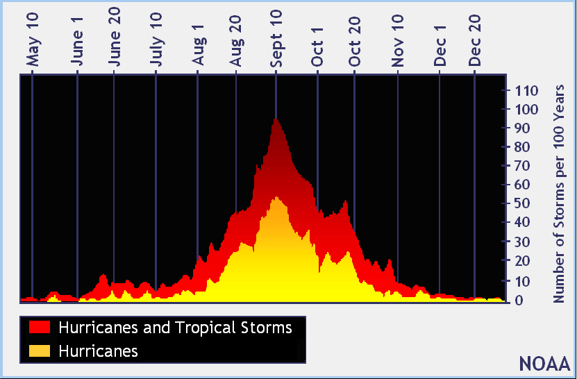
Image

Here is what Mark Sudduth discuss about this.

Will second half be as tame as first? Don’t count on it

Mark Sudduth | September 9, 2013

The first half of this year’s hurricane season has been nothing like what most people expected. So far, as of this posting, there have been zero hurricanes in the Atlantic. While that is likely to change within the next day or so, it is still remarkable to go this long in to the season with no hurricanes forming anywhere in the Atlantic Basin.

We can get in to why the season has been so slow later, there will be plenty of time for reflection once all is said and done. For now, let’s look at what lies ahead as I think some important signals are out there, coupled with history, that cannot be ignored.

First, as I mentioned, it looks like Humberto will become the season’s first hurricane by some time tomorrow. This will keep the record latest date intact by about a day. This will bring the season totals to eight named storms and one hurricane – two hurricanes short of where we would be in a typical season. We are also about a week behind on seeing the season’s first major hurricane – one of category 3, 4 or 5. There is a chance that Humberto could become a major hurricane though it may be tough, we’ll see.

Sea surface temps running above average across much of Atlantic Basin

A big factor going forward will be sea surface temps across the Atlantic Basin. Taking a look at today’s anomalies or departures from normal, we can see that there is a lot of warm water compared to average for this time of year. It is also important to note that this water is undisturbed by previous tropical cyclones. A considerable amount of upper ocean heat content lies in wait for something to come along and tap in to it. Obviously, warm water alone is not enough, but if conditions in the atmosphere are favorable, this added warmth can be the fuel for powerful hurricanes.

The other consideration is climatology. As we move through September, there is a natural shift in development areas back to the western Atlantic and Caribbean Sea. This concerns me a little because this region does not seem to have the dry air issues that the central and eastern Atlantic have had all season long. Need proof? Look at Fernand and TD8 recently. Both went from tropical waves to quickly intensifying systems in short order. I believe that both would have become hurricanes had they not run out of water. The pattern will favor the western Caribbean and Gulf of Mexico over the coming weeks and this fits in with what we would normally look for this time of year.

Tracks of late September/October hurricanes from 2005, 2002, 1999, 1998 and 1989

Lastly, we need only to look in to the past as a guide to tell us that it’s not over until it’s over. We’ve seen some late season hurricanes come along that were very unpleasant. Wilma in late October of 2005 is part of a long list of such events. Rita was late September of that season. Hugo was also closer to the end of the month in 1989 as was Georges in 1998.

Do not mistake what I am saying for trying to keep interest up when there may be nothing to worry about at all. Believe me, if I saw that the season was truly as close to being “over” as could be, I would say so. We’ve seen years like that – most recently 2009. But even the really slow seasons have their Andrew once in a great while. I just don’t see any evidence to suggest that the next six weeks will be as quiet as the first part of the season was.

Another thing to consider – global tropical cyclone activity has been way down in recent weeks. That is changing right now with a super-typhoon forecast to develop in the west Pacific and of course Humberto strengthening in the Atlantic. What ever this lull was, it looks like it is about to end. The Atlantic Basin is primed for activity now, as it should be this time of year. I just don’t want people to ignore things and let their guard down. It would be incredible to get through this season without a major impact from a hurricane but do not count on that happening based solely on the first half of the season.

Maybe it’s like someone simply forgot to pre-heat the oven but now that’s it’s ready, baking can commence.

As for Humberto and the rest of the tropics? Well, we need not worry too much about Humberto as steering patterns suggest it will remain way out in the eastern Atlantic, roaming around for a few days at least.

We do need to monitor the southwest Gulf of Mexico once again for potential development there later this week. As I said, that general region has been quite the hot spot this season and pressures remain low in the area. We could see some activity there in the coming days which will mean more rain and unsettled weather for parts of the Gulf and Mexico.

The east Pacific is quiet but watch for quite the typhoon to develop farther to the west as activity begins to ramp up again globally.

I’ll have more here late this afternoon or early evening on Humberto.

M. Sudduth 11:30 am ET Sept 9


This post is NOT AN OFFICIAL FORECAST and should not be used as such. It is just the opinion of the poster and may or may not be backed by sound meteorological data. It is NOT endorsed by any professional institution including storm2k.org. For Official Information please refer to the NHC and NWS products.
0 likes   
Visit the Caribbean-Central America Weather Thread where you can find at first post web cams,radars
and observations from Caribbean basin members Click Here

WeatherGuesser
Category 5
Category 5
Posts: 2672
Joined: Tue Jun 29, 2010 6:46 am

Re: Thoughts on activity as heart of season nears

#895 Postby WeatherGuesser » Tue Sep 10, 2013 9:30 am

cycloneye wrote:The heart of the season has arrived. But will the second half be loaded with activity?


Again, I go back to .....

This may be true for the formally defined season, but what about the perceived late/delayed season?
0 likes   

User avatar
Hurricane_Luis
Category 2
Category 2
Posts: 723
Age: 27
Joined: Sat Jun 23, 2012 3:14 pm
Location: Tiptree, Essex, United Kingdom
Contact:

#896 Postby Hurricane_Luis » Tue Sep 10, 2013 9:51 am

Countdown to record: 17 hours 9 minutes 25 seconds (As of 15:48 UTC 10/9/13)

Its gonna be really close, Humberto is a 65 mph TS, About 10 mph from hurricane strength.
0 likes   

User avatar
Hammy
Category 5
Category 5
Posts: 5849
Age: 41
Joined: Fri May 25, 2012 5:25 pm
Contact:

Re:

#897 Postby Hammy » Tue Sep 10, 2013 11:56 am

Hurricane_Luis wrote:Countdown to record: 17 hours 9 minutes 25 seconds (As of 15:48 UTC 10/9/13)

Its gonna be really close, Humberto is a 65 mph TS, About 10 mph from hurricane strength.


Record will likely be broken as a large area of dry air continues to move south towards Humberto, now forcing the northern edge of the outflow southward as well as seeming to strangle the convection which has been quickly collapsing.

http://rammb.cira.colostate.edu/products/tc_realtime/loop.asp?product=16kmgwvp&storm_identifier=AL092013&starting_image=2013AL09_16KMGWVP_201309082115.GIF

The posts in this forum are NOT official forecast and should not be used as such. They are just the opinion of the poster and may or may not be backed by sound meteorological data. They are NOT endorsed by any professional institution or storm2k.org. For official information, please refer to the NHC and NWS products.
Last edited by tolakram on Tue Sep 10, 2013 12:13 pm, edited 1 time in total.
Reason: added disclaimer
0 likes   
The above post is not official and should not be used as such. It is the opinion of the poster and may or may not be backed by sound meteorological data. It is not endorsed by any professional institution or storm2k.org. For official information, please refer to the NHC and NWS products.

tolakram
Admin
Admin
Posts: 20009
Age: 62
Joined: Sun Aug 27, 2006 8:23 pm
Location: Florence, KY (name is Mark)

Re: Thoughts on activity as heart of season nears

#898 Postby tolakram » Tue Sep 10, 2013 12:15 pm

I think we've been a little loose with the disclaimer requirement and need to tighten it up a bit. If you are predicting something or making an analysis please remember to include the disclaimer and present evidence as to why something is happening. This helps all of us understand what might be going on.

Thanks.
0 likes   
M a r k
- - - - -
Join us in chat: Storm2K Chatroom Invite. Android and IOS apps also available.

The posts in this forum are NOT official forecasts and should not be used as such. Posts are NOT endorsed by any professional institution or STORM2K.org. For official information and forecasts, please refer to NHC and NWS products.

User avatar
Ntxw
Storm2k Moderator
Storm2k Moderator
Posts: 22784
Joined: Wed Oct 21, 2009 6:34 pm
Location: DFW, Texas

#899 Postby Ntxw » Tue Sep 10, 2013 10:19 pm

Well folks we may or may not beat 2002 officially (officially sometime tomorrow morning) but with the latest Humberto advisory still a TS 2013 will accompany 2002 as latest date (Sept 11) for first hurricane.
0 likes   
The above post and any post by Ntxw is NOT an official forecast and should not be used as such. It is just the opinion of the poster and may or may not be backed by sound meteorological data. It is NOT endorsed by any professional institution including Storm2k. For official information, please refer to NWS products.

  Help support Storm2K!
Help Support Storm2K

User avatar
SoupBone
Category 5
Category 5
Posts: 3111
Joined: Tue Sep 20, 2005 5:24 pm

Re:

#900 Postby SoupBone » Wed Sep 11, 2013 12:15 am

Ntxw wrote:Well folks we may or may not beat 2002 officially (officially sometime tomorrow morning) but with the latest Humberto advisory still a TS 2013 will accompany 2002 as latest date (Sept 11) for first hurricane.


It's a pretty awesome record to break in my opinion. We don't see many like this one so enjoy it considering how rare it is. We're almost there.
0 likes   
Personal Forecast Disclaimer:
The posts in this forum are NOT official forecast and should not be used as such. They are just the opinion of the poster and may or may not be backed by sound meteorological data. They are NOT endorsed by any professional institution or storm2k.org. For official information, please refer to the NHC and NWS products.


Return to “Talkin' Tropics”

Who is online

Users browsing this forum: No registered users and 30 guests