2020 Global Model Runs Discussion (Out thru day 16)
Moderator: S2k Moderators
Forum rules

The posts in this forum are NOT official forecasts and should not be used as such. They are just the opinion of the poster and may or may not be backed by sound meteorological data. They are NOT endorsed by any professional institution or STORM2K. For official information, please refer to products from the National Hurricane Center and National Weather Service.
-
Ivanhater

- Storm2k Moderator

- Posts: 11221
- Age: 39
- Joined: Fri Jul 01, 2005 8:25 am
- Location: Pensacola
Re: 2020 Global Model Runs Discussion (Out thru day 16)
Yep, 00Z Euro is showing a possible Caribbean cruiser. I do believe this season is cleared for takeoff
4 likes
Michael
-
gatorcane

- S2K Supporter

- Posts: 23708
- Age: 48
- Joined: Sun Mar 13, 2005 3:54 pm
- Location: Boca Raton, FL
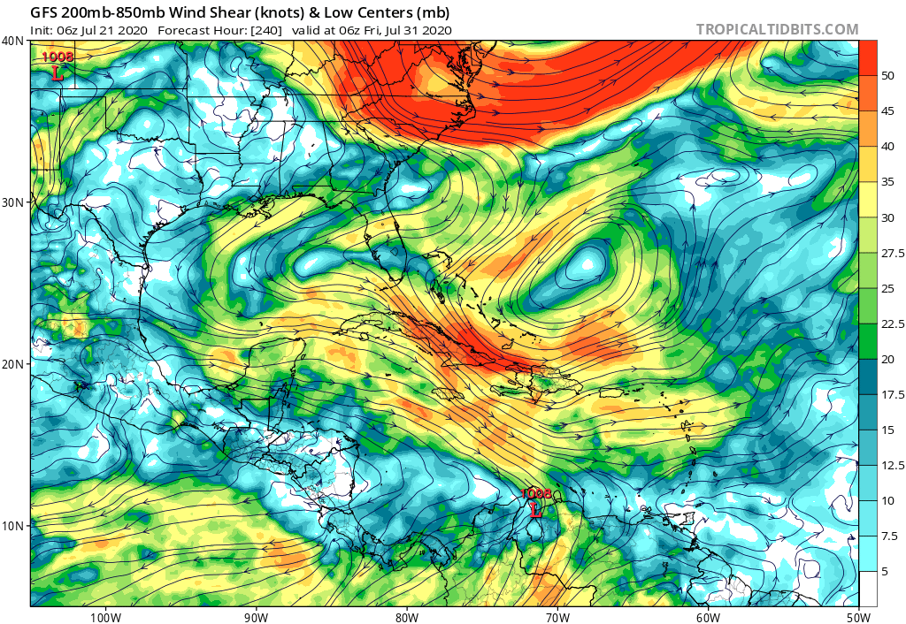
Re: 2020 Global Model Runs Discussion (Out thru day 16)
The GFS has nothing in that same timeframe. Take a look at the ripping shear from the TUTT:
1 likes
-
supercane4867
- Category 5

- Posts: 4966
- Joined: Wed Nov 14, 2012 10:43 am
Re: 2020 Global Model Runs Discussion (Out thru day 16)
gatorcane wrote:
The GFS has nothing in that same timeframe. Take a look at the ripping shear from the TUTT:
https://i.postimg.cc/rwxNN8cq/gfs-shear-watl-41.png
Long range shear forecast is garbage.
3 likes

-
toad strangler

- S2K Supporter
- Posts: 4546
- Joined: Sun Jul 28, 2013 3:09 pm
- Location: Earth
- Contact:
-
TheStormExpert
Re: 2020 Global Model Runs Discussion (Out thru day 16)
gatorcane wrote:
The GFS has nothing in that same timeframe. Take a look at the ripping shear from the TUTT:
https://i.postimg.cc/rwxNN8cq/gfs-shear-watl-41.png
You seem very pessimistic about this season. Besides the GFS has been consistently over-analyzing shear in the Atlantic.
0 likes
-
stormlover2013
Re: 2020 Global Model Runs Discussion (Out thru day 16)
TheStormExpert wrote:gatorcane wrote:
The GFS has nothing in that same timeframe. Take a look at the ripping shear from the TUTT:
Gfs sucks
https://i.postimg.cc/rwxNN8cq/gfs-shear-watl-41.png
You seem very pessimistic about this season. Besides the GFS has been consistently over-analyzing shear in the Atlantic.
0 likes
-
toad strangler
- S2K Supporter
- Posts: 4546
- Joined: Sun Jul 28, 2013 3:09 pm
- Location: Earth
- Contact:
Re: 2020 Global Model Runs Discussion (Out thru day 16)
Just a few days ago the models saw NOTHING through the end of July and into August. Just like that we have two systems with a chance at being classified. I've never ever trusted modeling in general to sniff out genesis.
3 likes
My Weather Station
https://www.wunderground.com/dashboard/pws/KFLPORTS603
https://www.wunderground.com/dashboard/pws/KFLPORTS603
-
TheStormExpert
Re: 2020 Global Model Runs Discussion (Out thru day 16)
toad strangler wrote:Just a few days ago the models saw NOTHING through the end of July and into August. Just like that we have two systems with a chance at being classified. I've never ever trusted modeling in general to sniff out genesis.
Yep, just like that things can FASTLY change.
0 likes
-
AnnularCane

- S2K Supporter
- Posts: 2962
- Joined: Thu Jun 08, 2006 9:18 am
- Location: Wytheville, VA
Re: 2020 Global Model Runs Discussion (Out thru day 16)
toad strangler wrote:Just a few days ago the models saw NOTHING through the end of July and into August. Just like that we have two systems with a chance at being classified. I've never ever trusted modeling in general to sniff out genesis.
Hence why cancelling the rest of the month, let alone the season, because there's nothing on the models at any given time is risky business.
5 likes
-
EquusStorm
- Category 5
- Posts: 1649
- Age: 35
- Joined: Thu Nov 07, 2013 1:04 pm
- Location: Jasper, AL
- Contact:
Re: 2020 Global Model Runs Discussion (Out thru day 16)
I remember the season cancel a couple weeks before Dorian leveled part of the Bahamas (in a season that ended with 18 named storms) and the season cancel a couple weeks before Michael (and two more October systems) so I'm becoming convinced it's just standard discussion fodder whenever there's no currently active major hurricane bearing down on a population center
4 likes
Colors of lost purpose on the canvas of irrelevance
Not a meteorologist, in fact more of an idiot than anything. You should probably check with the NHC or a local NWS office for official information.
Not a meteorologist, in fact more of an idiot than anything. You should probably check with the NHC or a local NWS office for official information.

Re: 2020 Global Model Runs Discussion (Out thru day 16)
It's ridiculous and silly. It's okay to try to anticipate things, but if you're wrong, there's no sense in doubling down on a losing argument. Weather models are one thing, but I feel like you have to consider other factors besides the models. MJO forecast (a different kind of model) is kind of key for this season.
https://www.cpc.ncep.noaa.gov/products/ ... r_wh.shtml
MJO is in fact pushing into 2 where it should be for a few days. I knew we would be getting out of July with a "G" storm, but I didn't think we'd also have an "H" depending on what future 91L does (maybe TS, maybe TD). Regardless, this is probably the most interesting early season since at least 2005. There has been a ton of action even though most of it has been weak. There have been many July's where the arguments were about whether a season would ever get started. This ain't one of those years.
7 likes
-
Shell Mound
- Category 5
- Posts: 2432
- Age: 33
- Joined: Thu Sep 07, 2017 3:39 pm
- Location: St. Petersburg, FL → Scandinavia
Re: 2020 Global Model Runs Discussion (Out thru day 16)
https://twitter.com/JamesBelanger/status/1285560007979827201
https://twitter.com/MJVentrice/status/1285551652712456192
https://twitter.com/webberweather/status/1285489212691820548
And some humour:
https://twitter.com/stormchasernick/status/1285541980982968321
https://twitter.com/MJVentrice/status/1285551652712456192
https://twitter.com/webberweather/status/1285489212691820548
And some humour:
https://twitter.com/stormchasernick/status/1285541980982968321
2 likes
CVW / MiamiensisWx / Shell Mound
The posts in this forum are NOT official forecasts and should not be used as such. They are just the opinion of the poster and may or may not be backed by sound meteorological data. They are NOT endorsed by any professional institution or STORM2K. For official information, please refer to products from the NHC and NWS.

Re: 2020 Global Model Runs Discussion (Out thru day 16)
In response to the third tweet: I think that’s the precursor wave to the TC both the CFS and now the Euro have been showing for the end of July. It’s way too early to make any concrete predictions about development, but the right conditions do seem to be ready for it. Definitely something to keep an eye on.
0 likes
Irene '11 Sandy '12 Hermine '16 5/15/2018 Derecho Fay '20 Isaias '20 Elsa '21 Henri '21 Ida '21
I am only a meteorology enthusiast who knows a decent amount about tropical cyclones. Look to the professional mets, the NHC, or your local weather office for the best information.
I am only a meteorology enthusiast who knows a decent amount about tropical cyclones. Look to the professional mets, the NHC, or your local weather office for the best information.

Re: 2020 Global Model Runs Discussion (Out thru day 16)
gatorcane wrote:
The GFS has nothing in that same timeframe. Take a look at the ripping shear from the TUTT:
https://i.postimg.cc/rwxNN8cq/gfs-shear-watl-41.png
Come on Gator, you know that shear is the hardest thing for models to forecast past 5 days, if not 3-4.
Plus this particular GFS's shear graphic is exaggerated by a good 5-10 knots, as I have previously shown.
9 likes
-
toad strangler
- S2K Supporter
- Posts: 4546
- Joined: Sun Jul 28, 2013 3:09 pm
- Location: Earth
- Contact:
Re: 2020 Global Model Runs Discussion (Out thru day 16)
NDG wrote:gatorcane wrote:
The GFS has nothing in that same timeframe. Take a look at the ripping shear from the TUTT:
https://i.postimg.cc/rwxNN8cq/gfs-shear-watl-41.png
Come on Gator, you know that shear is the hardest thing for models to forecast past 5 days, if not 3-4.
Plus this particular GFS's shear graphic is exaggerated by a good 5-10 knots, as I have previously shown.
gator much more bearish than I can remember since joining this place 7 years ago. All during this time of unrelenting signals. Normally I’m pretty reserved but how could you given what’s been coming together so far?
1 likes
My Weather Station
https://www.wunderground.com/dashboard/pws/KFLPORTS603
https://www.wunderground.com/dashboard/pws/KFLPORTS603
Re: 2020 Global Model Runs Discussion (Out thru day 16)
A tropical wave currently over Africa has model support for development in the MDR next week. The wave will emerge into the MDR in 72-96 hours, and the Euro, CMC, and ICON runs for 12z all develop it in 144-196 hours. It has also appeared on the EPS ensembles. While development is still a ways off, it’ll be after the suppressive CCKW moves out of the basin, and the wave will emerge off the coast of Africa in only a few days. This will be another very interesting disturbance to keep an eye on.
3 likes
Irene '11 Sandy '12 Hermine '16 5/15/2018 Derecho Fay '20 Isaias '20 Elsa '21 Henri '21 Ida '21
I am only a meteorology enthusiast who knows a decent amount about tropical cyclones. Look to the professional mets, the NHC, or your local weather office for the best information.
I am only a meteorology enthusiast who knows a decent amount about tropical cyclones. Look to the professional mets, the NHC, or your local weather office for the best information.
-
CyclonicFury

- Category 5
- Posts: 2033
- Age: 27
- Joined: Sun Jul 02, 2017 12:32 pm
- Location: NC
- Contact:
Re: 2020 Global Model Runs Discussion (Out thru day 16)
EPS going crazy in early August 

2 likes
NCSU B.S. in Meteorology Class of 2021. Tropical weather blogger at http://www.cyclonicfury.com. My forecasts and thoughts are NOT official, for official forecasts please consult the National Hurricane Center.

Re: 2020 Global Model Runs Discussion (Out thru day 16)
GEM seems like the best model to watch this season--it was the only one developing 99L and was likewise the only one that wasn't spinning up phantom storm after phantom storm in either basin over the last few seasons. Whatever the upgrade was last year it fixed a lot of the genesis problems.
0 likes
The above post is not official and should not be used as such. It is the opinion of the poster and may or may not be backed by sound meteorological data. It is not endorsed by any professional institution or storm2k.org. For official information, please refer to the NHC and NWS products.
-
Hurricane Mike
- Category 2

- Posts: 675
- Joined: Tue Apr 10, 2018 7:44 am
Re: 2020 Global Model Runs Discussion (Out thru day 16)
Are those private or public viewing models?
0 likes
Who is online
Users browsing this forum: CyclonicFury and 143 guests