2025 Global Model Runs Discussion (Out thru day 16)
Moderator: S2k Moderators
Forum rules

The posts in this forum are NOT official forecasts and should not be used as such. They are just the opinion of the poster and may or may not be backed by sound meteorological data. They are NOT endorsed by any professional institution or STORM2K. For official information, please refer to products from the National Hurricane Center and National Weather Service.

Re: 2025 Global Model Runs Discussion (Out thru day 16)
MY take from the last post is that it is September 8 and one has to go the the 384 hour panel of the off hour TC happy GFS to look for a threat.
1 likes
Re: 2025 Global Model Runs Discussion (Out thru day 16)
Bigtenfan wrote:MY take from the last post is that it is September 8 and one has to go the the 384 hour panel of the off hour TC happy GFS to look for a threat.
The 06z gfs has a system in the BOC lifting north through the Gulf starting around day 8. This is the 5th run in a row.
0 likes
-
cycloneye

- Admin

- Posts: 149686
- Age: 69
- Joined: Thu Oct 10, 2002 10:54 am
- Location: San Juan, Puerto Rico
Re: 2025 Global Model Runs Discussion (Out thru day 16)
Bigtenfan wrote:MY take from the last post is that it is September 8 and one has to go the the 384 hour panel of the off hour TC happy GFS to look for a threat.
This models thread is about posting runs that go thru day 16.
0 likes
Visit the Caribbean-Central America Weather Thread where you can find at first post web cams,radars
and observations from Caribbean basin members Click Here
and observations from Caribbean basin members Click Here
-
DunedinDave
- Category 1

- Posts: 269
- Joined: Fri Aug 25, 2023 10:31 am
Re: 2025 Global Model Runs Discussion (Out thru day 16)
Outside of the GFS probably just being the GFS, its looking pretty quiet in a season that’s supposed to be explosive.
But I have a question. When Milton formed in the Gulf, was it something that all models were on board with well before it formed…or did it come out of nowhere?
But I have a question. When Milton formed in the Gulf, was it something that all models were on board with well before it formed…or did it come out of nowhere?
0 likes
-
TampaWxLurker
- Tropical Storm

- Posts: 196
- Joined: Thu Aug 01, 2024 8:20 am
Re: 2025 Global Model Runs Discussion (Out thru day 16)
At least we're back to "normal" and the GFS is seeing its requisite 10-day-out ghost storm again.
0 likes
Re: 2025 Global Model Runs Discussion (Out thru day 16)
Euro has something in the MDR at about 14N/ 40W on september 23
0 likes
-
Category5Kaiju

- Category 5

- Posts: 4345
- Joined: Thu Dec 24, 2020 12:45 pm
- Location: Seattle during the summer, Phoenix during the winter
Re: 2025 Global Model Runs Discussion (Out thru day 16)
DunedinDave wrote:Outside of the GFS probably just being the GFS, its looking pretty quiet in a season that’s supposed to be explosive.
But I have a question. When Milton formed in the Gulf, was it something that all models were on board with well before it formed…or did it come out of nowhere?
Looking back at Milton's model thread, the models (notably the Euro) started to note the possibility of it becoming something big on October 4 (literally one day before it formed). Before then, it seemed likely that it would've been a weak storm or even just a frontal low as models weren't very enthusiastic about it (or, at least, didn't "see" its potential).
With Helene, models didn't really start noting its potentially high ceiling until September 22, 4 days before it made landfall and 2 days before it formed.
Something I've noticed over the years is that there are storms like Irma, Lee, and Erin that models have a good grasp on even a week out (the idea being that such storm could end up as a powerful, long-lived system), and storms like Helene and Milton that models have a good grasp on merely days before said storm forms. I think this is something to definitely keep in mind as we progress through this lull.
3 likes
Unless explicitly stated, all information in my posts is based on my own opinions and observations. Tropical storms and hurricanes can be extremely dangerous. Refer to an accredited weather research agency or meteorologist if you need to make serious decisions regarding an approaching storm.
-
chris_fit

- Category 5
- Posts: 3261
- Age: 43
- Joined: Wed Sep 10, 2003 11:58 pm
- Location: Tampa Bay Area, FL
Re: 2025 Global Model Runs Discussion (Out thru day 16)
DunedinDave wrote:Outside of the GFS probably just being the GFS, its looking pretty quiet in a season that’s supposed to be explosive.
But I have a question. When Milton formed in the Gulf, was it something that all models were on board with well before it formed…or did it come out of nowhere?
Here is the "possible development" of Milton Thread. Even before it was an invest - https://www.storm2k.org/phpbb2/viewtopi ... 1&t=124360
TLDR; It had fooled pretty much everyone, including several pro-mets here, up until 2-3 days before it formed.
3 likes
-
TampaWxLurker
- Tropical Storm
- Posts: 196
- Joined: Thu Aug 01, 2024 8:20 am
Re: 2025 Global Model Runs Discussion (Out thru day 16)
Those CAG-originating storms in the BOC/Western Caribbean generally seem a lot harder to sniff out more than a week out because CAG formation always seems to be such slapdash, last-minute mayhem. As opposed to the classic Cape Verde storms that line up in an orderly row to exit off Africa and can be seen coming for awhile.
2 likes
-
Stratton23
- Category 5
- Posts: 3573
- Joined: Fri Jul 21, 2023 10:59 pm
- Location: Katy, Tx
Re: 2025 Global Model Runs Discussion (Out thru day 16)
GFS still makes sense to me with its CAG solution because the GEFS stalls the MJO in phases 8/1 and those phases favor closer to home development in the western half of the basin, we will see
1 likes
-
TomballEd
- Category 5
- Posts: 1317
- Age: 62
- Joined: Wed Aug 16, 2023 4:52 pm
- Location: Spring/Klein area, not Tomball
Re: 2025 Global Model Runs Discussion (Out thru day 16)
OURAGAN wrote:Euro has something in the MDR at about 14N/ 40W on september 23
GFS and Euro ensembles see at least one MDR system. Getting late for systems that form too far E to make it to CONUS but the first of the MDR systems could be a Caribbean threat. That could lead to a CONUS threat even near the equinox.
The Gulf thing, a couple of Euro ensemble perturbations see a Gulf system after 10 days. Or, there isn't a lot of support. Its a GFS thing and GFS seems to have a thing about spurious cyclones developing E of Central America.

2 likes
-
TomballEd
- Category 5
- Posts: 1317
- Age: 62
- Joined: Wed Aug 16, 2023 4:52 pm
- Location: Spring/Klein area, not Tomball
Re: 2025 Global Model Runs Discussion (Out thru day 16)
Shear looks fierce in the Gulf on all the models. 6Z GFS runs its storm into that.
0 likes
-
Stratton23
- Category 5
- Posts: 3573
- Joined: Fri Jul 21, 2023 10:59 pm
- Location: Katy, Tx
Re: 2025 Global Model Runs Discussion (Out thru day 16)
GFS continues to show its CAG idea and a new storm developing from a wave off africa, GFS is clearly seeing the effects of the MJO, which is why im giving it more weight then usually, should see other models start to wake up soon
2 likes
Re: 2025 Global Model Runs Discussion (Out thru day 16)
12z GFS doing the dual low thing with Florida split down the middle. All I think this means is a pattern shift being hinted at. I seriously doubt either will develop. But after 91L, we're set up to get sucker punched.

Last edited by BobHarlem on Mon Sep 08, 2025 11:48 am, edited 1 time in total.
1 likes
Re: 2025 Global Model Runs Discussion (Out thru day 16)
I'm hoping that dry air pattern holds up in the long-run, so that if we do get something in the Gulf it's more of a subtropical-like threat.
0 likes

Re: 2025 Global Model Runs Discussion (Out thru day 16)
12Z UKMET
NEW TROPICAL CYCLONE FORECAST TO DEVELOP AFTER 150 HOURS
FORECAST POSITION AT T+150 : 13.9N 32.5W
LEAD CENTRAL MAXIMUM WIND
VERIFYING TIME TIME POSITION PRESSURE (MB) SPEED (KNOTS)
-------------- ---- -------- ------------- -------------
0000UTC 15.09.2025 156 15.0N 33.7W 1012 27
1200UTC 15.09.2025 168 15.1N 37.9W 1010 33
0 likes
Personal Forecast Disclaimer:
The posts in this forum are NOT official forecasts and should not be used as such. They are just the opinion of the poster and may or may not be backed by sound meteorological data. They are NOT endorsed by any professional institution or storm2k.org. For official information, please refer to the NHC and NWS products.
The posts in this forum are NOT official forecasts and should not be used as such. They are just the opinion of the poster and may or may not be backed by sound meteorological data. They are NOT endorsed by any professional institution or storm2k.org. For official information, please refer to the NHC and NWS products.
-
TomballEd
- Category 5
- Posts: 1317
- Age: 62
- Joined: Wed Aug 16, 2023 4:52 pm
- Location: Spring/Klein area, not Tomball
Re: 2025 Global Model Runs Discussion (Out thru day 16)
GFS has about 50 knots of shear from the S pushing dry air into the Gulf storm. Even if it develops, it would be weak.

1 likes
-
Stratton23
- Category 5
- Posts: 3573
- Joined: Fri Jul 21, 2023 10:59 pm
- Location: Katy, Tx
Re: 2025 Global Model Runs Discussion (Out thru day 16)
Its long range, but thats the first run of the 12z EPS that actually shows the basin coming to life, interestingly to point out is how most of its signal for activity is focused in the western half of the basin, alines right with my thinking and MJO going into 8/1
1 likes

Re: 2025 Global Model Runs Discussion (Out thru day 16)
Stratton23 wrote:Its long range, but thats the first run of the 12z EPS that actually shows the basin coming to life, interestingly to point out is how most of its signal for activity is focused in the western half of the basin, alines right with my thinking and MJO going into 8/1
For reference, here's a loop with the 0z EPS earlier today, then 12z for the same forecast time (0z 9/18):
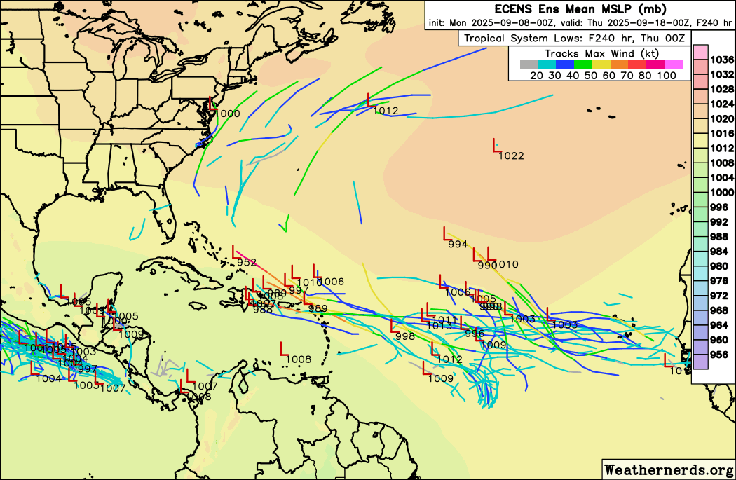
The most recent 4 GEFS runs for the same time:
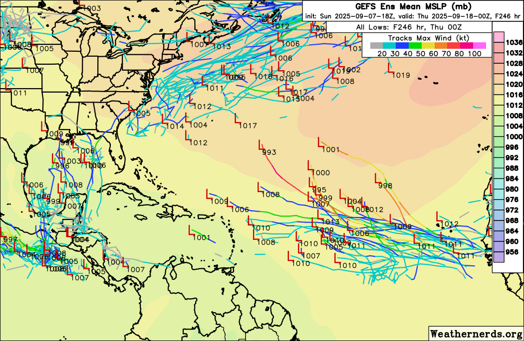
Overall, there's some indication in the Eastern Atlantic for a wave exiting Africa around 9/10 and another 9/13 on both ensemble models, but too early to tell. (GEFS's Gulf activity is largely muted on Euro.)
0 likes
TC naming lists: retirements and intensity
Most aggressive Advisory #1's in North Atlantic (cr. kevin for starting the list)
Most aggressive Advisory #1's in North Atlantic (cr. kevin for starting the list)
Re: 2025 Global Model Runs Discussion (Out thru day 16)
LarryWx wrote:I haven’t posted about the Euro Weeklies in awhile. Has anyone noticed that over the last few days that the Euro Weeklies have backed off of how active they were progging for the bulk of the rest of Sept?
% of 2005-2024 ACE
Sept 8-14: 0.6/0.5/0.5/0.4/0.2/0.2/0.1 (0.1 for that peak week is only ~2 ACE vs ~10 ACE 6 runs ago likely mainly related to 91L busting)
Sept 15-21: 1.2/1.1/0.9/0.7/0.8/0.9/0.5 (0.5 for that week is ~8 ACE vs ~19 ACE 6 runs ago likely partially related to 91L busting)
Sept 22-28: 1.3/1.1/1.0/1.2/1.1/0.7 (0.7 for that week is ~10 ACE vs ~19 ACE 5 runs ago (too far in future to be related to 91L busting)
So these 3 weeks, combined, they’ve dropped from an active ~48 to a well below avg ~20. A good portion of this of this almost has to be Invest 91L bust related. But not all of it.
Any thoughts? The Euro Weeklies have overall had a pretty good feel for things since 2024. Are they on to something or are they lost?
There was little change on the Euro Weeklies today with well BN ACE weeks 1-2 rising toward NN weeks 3-4.
0 likes
Personal Forecast Disclaimer:
The posts in this forum are NOT official forecasts and should not be used as such. They are just the opinion of the poster and may or may not be backed by sound meteorological data. They are NOT endorsed by any professional institution or storm2k.org. For official information, please refer to the NHC and NWS products.
The posts in this forum are NOT official forecasts and should not be used as such. They are just the opinion of the poster and may or may not be backed by sound meteorological data. They are NOT endorsed by any professional institution or storm2k.org. For official information, please refer to the NHC and NWS products.
Who is online
Users browsing this forum: No registered users and 262 guests