2023 Global Model Runs Discussion (Out thru day 16)

This is the general tropical discussion area. Anyone can take their shot at predicting a storms path.

Moderator: S2k Moderators

Forum rules

The posts in this forum are NOT official forecasts and should not be used as such. They are just the opinion of the poster and may or may not be backed by sound meteorological data. They are NOT endorsed by any professional institution or STORM2K. For official information, please refer to products from the National Hurricane Center and National Weather Service.

Help Support Storm2K
Message
Author
jlauderdal
S2K Supporter
S2K Supporter
Posts: 7177
Joined: Wed May 19, 2004 5:46 am
Location: NE Fort Lauderdale
Contact:

Re: 2023 Global Model Runs Discussion (Out thru day 16)

#921 Postby jlauderdal » Sun Aug 13, 2023 4:51 am

Stratton23 wrote:Beyond 10 days so just fantasy land, but that is one of the most disturbing tropical runs ive ever seen from the GFS, sub 930 MB cat 5 heading WNW

Many a major hurricanes have been depicted on the gfs over the years that never went nay further than "depicted". Have your plans in place at any rate, its aug. 13th and thats all the motivation you need.
3 likes   

USTropics
Category 5
Category 5
Posts: 2636
Joined: Sun Aug 12, 2007 3:45 am
Location: Florida State University

Re: 2023 Global Model Runs Discussion (Out thru day 16)

#922 Postby USTropics » Sun Aug 13, 2023 5:00 am

Teban54 wrote:0z Euro has a weak vort hitting Texas:
https://i.postimg.cc/vBQ38kZv/ecmwf-z850-vort-atl-59.png
This appears to be ahead of the Caribbean wave (the one currently offshore Africa that GFS just blew up). The distinction is seen most clearly on 0z CMC, which shows all 4 potential systems:
https://i.postimg.cc/3Rsj4qK6/gem-z850-vort-atl-41.png
0z GFS doesn't have it.


It's on the GFS, right along the Texas coastline at 216 hours. Here are all 4 wave axes highlighted:
Image

For this particular feature, I will point out it's not purely from a tropical wave. There is a low pressure area attached to a surface trough that is located near 30N59W that has been diving SW under the building subtropical ridge. This will become stretched out and how it interacts with an approaching wave is key:
Image

This is the 72 hour ECWMF forecast with both features highlighted:
Image
8 likes   

User avatar
cycloneye
Admin
Admin
Posts: 143897
Age: 68
Joined: Thu Oct 10, 2002 10:54 am
Location: San Juan, Puerto Rico

Re: 2023 Global Model Runs Discussion (Out thru day 16)

#923 Postby cycloneye » Sun Aug 13, 2023 6:56 am

Wait until the last week of August, Derek says. He may be right.

 https://twitter.com/DerekOrtt/status/1690578576809099264


1 likes   
Visit the Caribbean-Central America Weather Thread where you can find at first post web cams,radars
and observations from Caribbean basin members Click Here

User avatar
SFLcane
S2K Supporter
S2K Supporter
Posts: 10162
Age: 47
Joined: Sat Jun 05, 2010 1:44 pm
Location: Lake Worth Florida

Re: 2023 Global Model Runs Discussion (Out thru day 16)

#924 Postby SFLcane » Sun Aug 13, 2023 8:00 am

cycloneye wrote:Wait until the last week of August, Derek says. He may be right.

https://twitter.com/DerekOrtt/status/1690578576809099264


Yea just too dry right now until that thick Sal plume dies down and the epac not expecting much across the Atlantic.
1 likes   

User avatar
gatorcane
S2K Supporter
S2K Supporter
Posts: 23689
Age: 47
Joined: Sun Mar 13, 2005 3:54 pm
Location: Boca Raton, FL

Re: 2023 Global Model Runs Discussion (Out thru day 16)

#925 Postby gatorcane » Sun Aug 13, 2023 8:06 am

Doesn’t take a model to see why there shouldn’t be any development in the Atlantic any time soon. All of the rising motion and favorable conditions continue to remain over the EPAC. Look at the difference between the two basins on the infrared. No doubt El Niño is helping the EPAC:

Image
5 likes   

User avatar
Blown Away
S2K Supporter
S2K Supporter
Posts: 10140
Joined: Wed May 26, 2004 6:17 am

Re: 2023 Global Model Runs Discussion (Out thru day 16)

#926 Postby Blown Away » Sun Aug 13, 2023 9:05 am

cycloneye wrote:Wait until the last week of August, Derek says. He may be right.

https://twitter.com/DerekOrtt/status/1690578576809099264


The Euro/GFS model runs we’ve been following weren’t showing much until late August anyway and CMC is usually an outlier.
3 likes   
Hurricane Eye Experience: David 79, Irene 99, Frances 04, Jeanne 04, Wilma 05... EYE COMING MY WAY IN 2024…
Hurricane Brush Experience: Andrew 92, Erin 95, Floyd 99, Matthew 16, Irma 17, Ian 22, Nicole 22…

User avatar
Spacecoast
Category 2
Category 2
Posts: 758
Joined: Thu Aug 31, 2017 2:03 pm

Re: 2023 Global Model Runs Discussion (Out thru day 16)

#927 Postby Spacecoast » Sun Aug 13, 2023 9:14 am

0z EPS: TD Prob = ~35% into W Gulf @Day 10....
Image

Should bring some rain.


Euro, GFS, and NAV have chance of genesis in 4-5 days (wave #2??)
Image
Last edited by Spacecoast on Sun Aug 13, 2023 11:42 am, edited 2 times in total.
2 likes   

LarryWx
Category 5
Category 5
Posts: 6247
Joined: Sun Sep 07, 2003 2:04 pm
Location: GA

Re: 2023 Global Model Runs Discussion (Out thru day 16)

#928 Postby LarryWx » Sun Aug 13, 2023 9:50 am

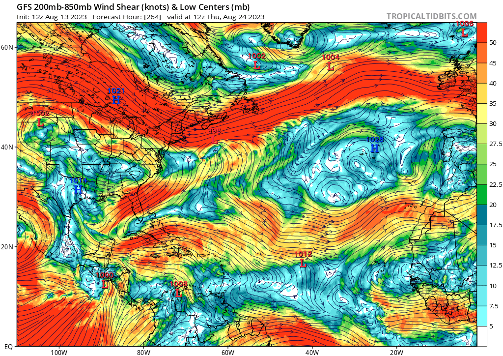
1. Today's 0Z EPS while still quite active isn't quite as active as yesterday's 12Z with the AEW now in the E MDR. It still is active with the 4 possibilities. And it is still much more active than those from the same time last year. Like night and day.

2. Today's 6Z GFS is the 7th GFS run since 7/31 with a H, this one appearing to form from a southern extension of the wave now in the E MDR. Thus it looks to me like at least the 4th GFS run with a H from this AEW. Also, today's 0Z and 6Z GFS are the first consecutive runs since 7/31 with a H. Prior to this, the closest that two GFS runs since 7/31 had a H was five runs apart:

-7/31 12Z: hit SC 8/16
-8/3 6Z: hit MX/TX border 8/16
-8/6 0Z: MDR 8/18-21
-8/9 18Z: just off SC 8/25
-8/11 0Z: just off LA 8/26
-8/13 0Z: GOM 8/26-8
-8/13 6Z: GOM 8/25-6 that hits MS 8/26-7
4 likes   
Personal Forecast Disclaimer:
The posts in this forum are NOT official forecasts and should not be used as such. They are just the opinion of the poster and may or may not be backed by sound meteorological data. They are NOT endorsed by any professional institution or storm2k.org. For official information, please refer to the NHC and NWS products.

Stratton23
Category 5
Category 5
Posts: 2372
Joined: Fri Jul 21, 2023 10:59 pm
Location: Katy, Tx

Re: 2023 Global Model Runs Discussion (Out thru day 16)

#929 Postby Stratton23 » Sun Aug 13, 2023 10:52 am

Havent had measurable rain here in se texas in probably 2 months, ill take a TD or a TS at this point,
6 likes   

LarryWx
Category 5
Category 5
Posts: 6247
Joined: Sun Sep 07, 2003 2:04 pm
Location: GA

Re: 2023 Global Model Runs Discussion (Out thru day 16)

#930 Postby LarryWx » Sun Aug 13, 2023 11:30 am

For the first time recently, the UKMET has Atlantic TCG (favoring recurving from the MDR):

NEW TROPICAL CYCLONE FORECAST TO DEVELOP AFTER 138 HOURS
FORECAST POSITION AT T+138 : 16.7N 42.6W

LEAD CENTRAL MAXIMUM WIND
VERIFYING TIME TIME POSITION PRESSURE (MB) SPEED (KNOTS)
-------------- ---- -------- ------------- -------------
1200UTC 19.08.2023 144 16.8N 42.7W 1009 29
0000UTC 20.08.2023 156 17.1N 43.1W 1008 31
1200UTC 20.08.2023 168 17.8N 43.8W 1007 33
1 likes   
Personal Forecast Disclaimer:
The posts in this forum are NOT official forecasts and should not be used as such. They are just the opinion of the poster and may or may not be backed by sound meteorological data. They are NOT endorsed by any professional institution or storm2k.org. For official information, please refer to the NHC and NWS products.

Stratton23
Category 5
Category 5
Posts: 2372
Joined: Fri Jul 21, 2023 10:59 pm
Location: Katy, Tx

Re: 2023 Global Model Runs Discussion (Out thru day 16)

#931 Postby Stratton23 » Sun Aug 13, 2023 11:32 am

12z CMC just spits out systems lol, system #1 looks to be a weak tropical storm approaching the texas coast , system #2 tries to consolidate in the caribbean and a third system out in the MDR develops as well
0 likes   

User avatar
chaser1
S2K Supporter
S2K Supporter
Posts: 5409
Age: 64
Joined: Sat Oct 15, 2005 5:59 pm
Location: Longwood, Fl

Re: 2023 Global Model Runs Discussion (Out thru day 16)

#932 Postby chaser1 » Sun Aug 13, 2023 12:01 pm

Meanwhile, GFS's Caribbean/Gulf hurricane that it has depicted for a few runs now.... dropped from latest 12Z run.
0 likes   
Andy D

(For official information, please refer to the NHC and NWS products.)

User avatar
gatorcane
S2K Supporter
S2K Supporter
Posts: 23689
Age: 47
Joined: Sun Mar 13, 2005 3:54 pm
Location: Boca Raton, FL

Re: 2023 Global Model Runs Discussion (Out thru day 16)

#933 Postby gatorcane » Sun Aug 13, 2023 12:03 pm

Take it with a grain of salt as it is 264 hours out, but the GFS looks to be modeling the kind of shear you would expect with an El Niño with strong upper-level westerlies from Central America to Africa:

Image
0 likes   

User avatar
chaser1
S2K Supporter
S2K Supporter
Posts: 5409
Age: 64
Joined: Sat Oct 15, 2005 5:59 pm
Location: Longwood, Fl

Re: 2023 Global Model Runs Discussion (Out thru day 16)

#934 Postby chaser1 » Sun Aug 13, 2023 12:11 pm

:uarrow: .... and with THAT look, the only region within the basin that might take note of the "bell" ringing might be limited to the sub-tropics east of 50W. That or some MDR "low-rider" that can find a way to remain below 15N.
0 likes   
Andy D

(For official information, please refer to the NHC and NWS products.)

User avatar
Ivanhater
Storm2k Moderator
Storm2k Moderator
Posts: 11153
Age: 38
Joined: Fri Jul 01, 2005 8:25 am
Location: Pensacola

Re: 2023 Global Model Runs Discussion (Out thru day 16)

#935 Postby Ivanhater » Sun Aug 13, 2023 12:21 pm

gatorcane wrote:Take it with a grain of salt as it is 264 hours out, but the GFS looks to be modeling the kind of shear you would expect with an El Niño with strong upper-level westerlies from Central America to Africa:

https://i.postimg.cc/sx8339PP/gfs-shear-atl-45.png


Not sure you are using the correct map. By that standard. The Epac "shear" looks worse than the Atlantic
2 likes   
Michael

User avatar
Ntxw
Storm2k Moderator
Storm2k Moderator
Posts: 22731
Joined: Wed Oct 21, 2009 6:34 pm
Location: DFW, Texas

Re: 2023 Global Model Runs Discussion (Out thru day 16)

#936 Postby Ntxw » Sun Aug 13, 2023 12:31 pm

Ivanhater wrote:
gatorcane wrote:Take it with a grain of salt as it is 264 hours out, but the GFS looks to be modeling the kind of shear you would expect with an El Niño with strong upper-level westerlies from Central America to Africa:

https://i.postimg.cc/sx8339PP/gfs-shear-atl-45.png


Not sure you are using the correct map. By that standard. The Epac "shear" looks worse than the Atlantic


On the map the EPAC shear is induced by modeled tropical cyclones in the lower lats. The Atlantic side is westerlies, two different components.
1 likes   
The above post and any post by Ntxw is NOT an official forecast and should not be used as such. It is just the opinion of the poster and may or may not be backed by sound meteorological data. It is NOT endorsed by any professional institution including Storm2k. For official information, please refer to NWS products.

  Help support Storm2K!
Help Support Storm2K

User avatar
Spacecoast
Category 2
Category 2
Posts: 758
Joined: Thu Aug 31, 2017 2:03 pm

Re: 2023 Global Model Runs Discussion (Out thru day 16)

#937 Postby Spacecoast » Sun Aug 13, 2023 12:36 pm

Ivanhater wrote:
gatorcane wrote:Take it with a grain of salt as it is 264 hours out, but the GFS looks to be modeling the kind of shear you would expect with an El Niño with strong upper-level westerlies from Central America to Africa:

https://i.postimg.cc/sx8339PP/gfs-shear-atl-45.png


Not sure you are using the correct map. By that standard. The Epac "shear" looks worse than the Atlantic

Not sure I am using the correct map (vortex removed), but here is the Euro during same period...
Image

That white spot near 20N, 60W seams to be particularly non-conducive.
Last edited by Spacecoast on Sun Aug 13, 2023 1:00 pm, edited 1 time in total.
1 likes   

User avatar
chaser1
S2K Supporter
S2K Supporter
Posts: 5409
Age: 64
Joined: Sat Oct 15, 2005 5:59 pm
Location: Longwood, Fl

Re: 2023 Global Model Runs Discussion (Out thru day 16)

#938 Postby chaser1 » Sun Aug 13, 2023 12:43 pm

Ivanhater wrote:
gatorcane wrote:Take it with a grain of salt as it is 264 hours out, but the GFS looks to be modeling the kind of shear you would expect with an El Niño with strong upper-level westerlies from Central America to Africa:

https://i.postimg.cc/sx8339PP/gfs-shear-atl-45.png


Not sure you are using the correct map. By that standard. The Epac "shear" looks worse than the Atlantic


Such shear might retard EPAC development, but not eliminate genesis. When I took a closer look at the EPAC itself, that shear quickly diverts from northerly to "easterly" (such as with any very strong Easterly surge pushing off the African Atlantic coast). I could see that as initially inhibiting but less so if development were to occur a bit north of those stronger winds. It is interesting how thus far, that lower latitude westerly shear seems to divert due south over Mexico rather then plow eastward across the Southern Caribbean. That would seem more indicative of what I would expect during a Nino event.
0 likes   
Andy D

(For official information, please refer to the NHC and NWS products.)

User avatar
chaser1
S2K Supporter
S2K Supporter
Posts: 5409
Age: 64
Joined: Sat Oct 15, 2005 5:59 pm
Location: Longwood, Fl

Re: 2023 Global Model Runs Discussion (Out thru day 16)

#939 Postby chaser1 » Sun Aug 13, 2023 12:59 pm

Spacecoast wrote:
Ivanhater wrote:
gatorcane wrote:Take it with a grain of salt as it is 264 hours out, but the GFS looks to be modeling the kind of shear you would expect with an El Niño with strong upper-level westerlies from Central America to Africa:

https://i.postimg.cc/sx8339PP/gfs-shear-atl-45.png


Not sure you are using the correct map. By that standard. The Epac "shear" looks worse than the Atlantic

Not sure I am using the correct map (vortex removed), but here is the Euro during same period...
https://i.ibb.co/6nVvGpM/ea4.jpg


Looks about right. Bottom line as gatorcane was indicating is that overall shear from about 15N to 30N would suggest pretty unfavorable conditions for that swath of real estate practically stretching across the entire basin (assuming that were to verify). The fact that both EURO and the GFS depict the same gives greater credence to those potential conditions. Over the years, that is where I would then turn my focus toward those goldilocks regions where genesis might still occur under more favorable conditions.
1 likes   
Andy D

(For official information, please refer to the NHC and NWS products.)

User avatar
Ivanhater
Storm2k Moderator
Storm2k Moderator
Posts: 11153
Age: 38
Joined: Fri Jul 01, 2005 8:25 am
Location: Pensacola

Re: 2023 Global Model Runs Discussion (Out thru day 16)

#940 Postby Ivanhater » Sun Aug 13, 2023 1:00 pm

Ntxw wrote:
Ivanhater wrote:
gatorcane wrote:Take it with a grain of salt as it is 264 hours out, but the GFS looks to be modeling the kind of shear you would expect with an El Niño with strong upper-level westerlies from Central America to Africa:

https://i.postimg.cc/sx8339PP/gfs-shear-atl-45.png


Not sure you are using the correct map. By that standard. The Epac "shear" looks worse than the Atlantic


On the map the EPAC shear is induced by modeled tropical cyclones in the lower lats. The Atlantic side is westerlies, two different components.


Correct. But picking that timestamp seems to be cherry picking. Shear is quite light before and after the posted timestamp over the Gulf and western Caribbean. Gfs is still hinting at development im this are by the end of August
2 likes   
Michael


Return to “Talkin' Tropics”

Who is online

Users browsing this forum: AnnularCane, cycloneye, emeraldislenc, Google Adsense [Bot], MetroMike, Sps123, WaveBreaking, zzzh and 195 guests