2024 Indicators: SST's, MSLP, Shear, SAL, Steering, Instability (Day 16+ Climate Models)

This is the general tropical discussion area. Anyone can take their shot at predicting a storms path.

Moderator: S2k Moderators

Forum rules

The posts in this forum are NOT official forecasts and should not be used as such. They are just the opinion of the poster and may or may not be backed by sound meteorological data. They are NOT endorsed by any professional institution or STORM2K. For official information, please refer to products from the National Hurricane Center and National Weather Service.

Help Support Storm2K
Message
Author
User avatar
chaser1
S2K Supporter
S2K Supporter
Posts: 4720
Age: 63
Joined: Sat Oct 15, 2005 5:59 pm
Location: Longwood, Fl

Re: 2024 Indicators: SST's, MSLP, Shear, SAL, Steering, Instability (Day 16+ Climate Models)

#921 Postby chaser1 » Wed May 15, 2024 6:02 pm


I totally agree. In fact, it further reinforces my thinking that this season will exhibit an unusual concentration of far West basin tracks. So many years have storm tracks that tend to "similarly flow". Kind of like a "fan", but perhaps with a second less primary set of tracks elsewhere. Some years we see those tracks "fan out" primarily in the Central Atlantic with a much more poleward trajectory. Then there's those years with a similar pattern but fanning out toward the West Atlantic. Of course, there's also been those hurricane seasons where the track map essentially looks as if someone had just thrown-up all over it :cheesy:
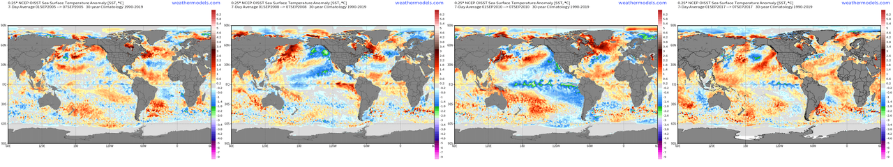
I was considering the idea of reviewing each year - by year - by year, out of curiosity just to see just how uncommon it was to experience a season where tropical cyclone tracks were predominately clustered west of 70W displaying a very west and NW bias motion from that point into the Central & West Caribbean as well as the GOM.
1 likes   
Personal Forecast Disclaimer:
The posts in this forum are NOT official forecast and should not be used as such. They are just the opinion of the poster and may or may not be backed by sound meteorological data. They are NOT endorsed by any professional institution or storm2k.org. For official information, please refer to the NHC and NWS products.


User avatar
cycloneye
Admin
Admin
Posts: 139410
Age: 67
Joined: Thu Oct 10, 2002 10:54 am
Location: San Juan, Puerto Rico

Re: 2024 Indicators: SST's, MSLP, Shear, SAL, Steering, Instability (Day 16+ Climate Models)

#922 Postby cycloneye » Wed May 15, 2024 7:02 pm

2 likes   
Visit the Caribbean-Central America Weather Thread where you can find at first post web cams,radars
and observations from Caribbean basin members Click Here

User avatar
JetFuel_SE
Category 1
Category 1
Posts: 275
Age: 24
Joined: Thu Apr 30, 2020 3:57 pm

Re: 2024 Indicators: SST's, MSLP, Shear, SAL, Steering, Instability (Day 16+ Climate Models)

#923 Postby JetFuel_SE » Thu May 16, 2024 3:32 am

chaser1 wrote: Of course, there's also been those hurricane seasons where the track map essentially looks as if someone had just thrown-up all over it :cheesy:

So basically 2005?
Image
3 likes   

Pas_Bon
Tropical Low
Tropical Low
Posts: 11
Age: 44
Joined: Mon Jul 15, 2019 12:25 pm
Location: League City, TX

Re: 2024 Indicators: SST's, MSLP, Shear, SAL, Steering, Instability (Day 16+ Climate Models)

#924 Postby Pas_Bon » Thu May 16, 2024 7:27 am

JetFuel_SE wrote:
chaser1 wrote: Of course, there's also been those hurricane seasons where the track map essentially looks as if someone had just thrown-up all over it :cheesy:

So basically 2005?
https://upload.wikimedia.org/wikipedia/commons/thumb/e/e0/2005_Atlantic_hurricane_season_summary_map.png/1163px-2005_Atlantic_hurricane_season_summary_map.png


*triggered*
0 likes   

tolakram
Admin
Admin
Posts: 19172
Age: 60
Joined: Sun Aug 27, 2006 8:23 pm
Location: Florence, KY (name is Mark)

Re: 2024 Indicators: SST's, MSLP, Shear, SAL, Steering, Instability (Day 16+ Climate Models)

#925 Postby tolakram » Thu May 16, 2024 7:36 am

JetFuel_SE wrote:
chaser1 wrote: Of course, there's also been those hurricane seasons where the track map essentially looks as if someone had just thrown-up all over it :cheesy:

So basically 2005?
https://upload.wikimedia.org/wikipedia/commons/thumb/e/e0/2005_Atlantic_hurricane_season_summary_map.png/1163px-2005_Atlantic_hurricane_season_summary_map.png


I don't think so, unless the MDR is shut down again. I'm not confident in any ridging forecast, but I do think we will see some long tracking MDR storms this year.
0 likes   
M a r k
- - - - -
Join us in chat: Storm2K Chatroom Invite. Android and IOS apps also available.

The posts in this forum are NOT official forecasts and should not be used as such. Posts are NOT endorsed by any professional institution or STORM2K.org. For official information and forecasts, please refer to NHC and NWS products.

User avatar
cycloneye
Admin
Admin
Posts: 139410
Age: 67
Joined: Thu Oct 10, 2002 10:54 am
Location: San Juan, Puerto Rico

Re: 2024 Indicators: SST's, MSLP, Shear, SAL, Steering, Instability (Day 16+ Climate Models)

#926 Postby cycloneye » Thu May 16, 2024 8:22 am

1 likes   
Visit the Caribbean-Central America Weather Thread where you can find at first post web cams,radars
and observations from Caribbean basin members Click Here

User avatar
chaser1
S2K Supporter
S2K Supporter
Posts: 4720
Age: 63
Joined: Sat Oct 15, 2005 5:59 pm
Location: Longwood, Fl

Re: 2024 Indicators: SST's, MSLP, Shear, SAL, Steering, Instability (Day 16+ Climate Models)

#927 Postby chaser1 » Thu May 16, 2024 9:20 am

tolakram wrote:
JetFuel_SE wrote:
chaser1 wrote: Of course, there's also been those hurricane seasons where the track map essentially looks as if someone had just thrown-up all over it :cheesy:

So basically 2005?
https://upload.wikimedia.org/wikipedia/commons/thumb/e/e0/2005_Atlantic_hurricane_season_summary_map.png/1163px-2005_Atlantic_hurricane_season_summary_map.png


I don't think so, unless the MDR is shut down again. I'm not confident in any ridging forecast, but I do think we will see some long tracking MDR storms this year.


Well, 2005 "was" an example of such a year where the final track map truly appeared like that thrown-up spagetti plate that I mentioned LOL; not at all the type of year/storm tracks that I would anticipate this year however.
In fact, if anything..... my guess would be for MDR development due to the very warm SST's with any storms tracking poleward to weaken given the significantly cooler water temps in the sub-tropics this year. Tolokram is right in saying that there likely will be some long MDR tracking storms. Of course another possibility could be that we see a good deal of MDR development that simply does not occur until reach some "magic longitude" and not develop as far east as other years. That is simply hard to say. The biggest issue (especially during an above average/hyperactive year) is where will storms track and which islands or land mass will be affected. I don't think a season somewhat like 2005 will occur.....where there was a broad distribution of storm tracks throughout the Atlantic basin. At minimum, I believe that:
1) a larger percentage of cyclone development will occur in the lower latitudes then sub-tropics
2) the Western Atlantic basin will be a greater focus of many of the storm tracks, as opposed to storm tracks being equally spread out through the Central Atlantic
3) An enhanced risk exists for the W. Caribbean, Central America, Mexico, S.E. CONUS and overall GOM region.
3 likes   
Personal Forecast Disclaimer:
The posts in this forum are NOT official forecast and should not be used as such. They are just the opinion of the poster and may or may not be backed by sound meteorological data. They are NOT endorsed by any professional institution or storm2k.org. For official information, please refer to the NHC and NWS products.


User avatar
skyline385
Category 5
Category 5
Posts: 2518
Age: 33
Joined: Wed Aug 26, 2020 11:15 pm
Location: Houston TX

Re: 2024 Indicators: SST's, MSLP, Shear, SAL, Steering, Instability (Day 16+ Climate Models)

#928 Postby skyline385 » Thu May 16, 2024 10:06 am

Always been curious why 2005 didn't have strong MDR runners despite the +AMO config, I wonder if it had to with the lingering cold pool near the equator from the Atlantic Nina which persisted between June-Aug 2005. Years like 2008, 2010 & 2017 did not much of a cold pool near the equator in September.

Image
2 likes   

User avatar
Category5Kaiju
Category 5
Category 5
Posts: 3411
Age: 22
Joined: Thu Dec 24, 2020 12:45 pm
Location: Seattle

Re: 2024 Indicators: SST's, MSLP, Shear, SAL, Steering, Instability (Day 16+ Climate Models)

#929 Postby Category5Kaiju » Thu May 16, 2024 10:18 am

skyline385 wrote:Always been curious why 2005 didn't have strong MDR runners despite the +AMO config, I wonder if it had to with the lingering cold pool near the equator from the Atlantic Nina which persisted between June-Aug 2005. Years like 2008, 2010 & 2017 did not much of a cold pool near the equator in September.

[url]https://i.postimg.cc/L65bgRkL/4-imageonline-co-merged.png [/url]


2005 was a bizarre year for many reasons, but I think what really stands out iirc is that it had this dry air/sinking air pattern in the open Atlantic but an exceptionally favorable West Atlantic. If you were to take out the West Atlantic, 2005 was quite a lackluster, unremarkable year. The precursor disturbances for storms such as Katrina and Rita went basically invisible throughout their journey from Africa. That is, until they blew up near Florida.

I could also say that 2020 featured this kind of similar pattern, except slightly more remarkable in the sense that we got Cat 4 Teddy in the open MDR.
2 likes   
Unless explicitly stated, all information covered in my posts is based on my opinions and observations. Please refer to a professional meteorologist or an accredited weather research agency otherwise, especially if serious decisions must be made in the event of a potentially life-threatening tropical storm or hurricane.

User avatar
wxman57
Moderator-Pro Met
Moderator-Pro Met
Posts: 22484
Age: 66
Joined: Sat Jun 21, 2003 8:06 pm
Location: Houston, TX (southwest)

Re: 2024 Indicators: SST's, MSLP, Shear, SAL, Steering, Instability (Day 16+ Climate Models)

#930 Postby wxman57 » Thu May 16, 2024 10:34 am

One thing I've observed this spring is very little SAL in the MDR. A sign of weaker trades? If that's the case, then it indicates a negative AMO, which would favor recurves east of the Caribbean. Forecast, though, is for a stronger Bermuda high during peak season.
2 likes   

User avatar
skyline385
Category 5
Category 5
Posts: 2518
Age: 33
Joined: Wed Aug 26, 2020 11:15 pm
Location: Houston TX

Re: 2024 Indicators: SST's, MSLP, Shear, SAL, Steering, Instability (Day 16+ Climate Models)

#931 Postby skyline385 » Thu May 16, 2024 10:48 am

Category5Kaiju wrote:
skyline385 wrote:Always been curious why 2005 didn't have strong MDR runners despite the +AMO config, I wonder if it had to with the lingering cold pool near the equator from the Atlantic Nina which persisted between June-Aug 2005. Years like 2008, 2010 & 2017 did not much of a cold pool near the equator in September.

[url]https://i.postimg.cc/L65bgRkL/4-imageonline-co-merged.png [/url]


2005 was a bizarre year for many reasons, but I think what really stands out iirc is that it had this dry air/sinking air pattern in the open Atlantic but an exceptionally favorable West Atlantic. If you were to take out the West Atlantic, 2005 was quite a lackluster, unremarkable year. The precursor disturbances for storms such as Katrina and Rita went basically invisible throughout their journey from Africa. That is, until they blew up near Florida.

I could also say that 2020 featured this kind of similar pattern, except slightly more remarkable in the sense that we got Cat 4 Teddy in the open MDR.


Yea, the sinking air in the deep tropics again goes back to lack of an Atlantic Nino which has recently been correlated to long lived CV systems forming in the deep tropics. Of course there are limited studies in regards to the Atlantic Nino but so far the lack of it could be a possible culprit for lack of strong CV systems in 2005. Here is a recent paper and associated article for it:

https://www.nature.com/articles/s41467-023-39467-5
https://www.aoml.noaa.gov/scientists-di ... -cyclones/
1 likes   

Pas_Bon
Tropical Low
Tropical Low
Posts: 11
Age: 44
Joined: Mon Jul 15, 2019 12:25 pm
Location: League City, TX

Re: 2024 Indicators: SST's, MSLP, Shear, SAL, Steering, Instability (Day 16+ Climate Models)

#932 Postby Pas_Bon » Thu May 16, 2024 12:38 pm

Category5Kaiju wrote:
skyline385 wrote:Always been curious why 2005 didn't have strong MDR runners despite the +AMO config, I wonder if it had to with the lingering cold pool near the equator from the Atlantic Nina which persisted between June-Aug 2005. Years like 2008, 2010 & 2017 did not much of a cold pool near the equator in September.

[url]https://i.postimg.cc/L65bgRkL/4-imageonline-co-merged.png [/url]


2005 was a bizarre year for many reasons, but I think what really stands out iirc is that it had this dry air/sinking air pattern in the open Atlantic but an exceptionally favorable West Atlantic. If you were to take out the West Atlantic, 2005 was quite a lackluster, unremarkable year. The precursor disturbances for storms such as Katrina and Rita went basically invisible throughout their journey from Africa. That is, until they blew up near Florida.

I could also say that 2020 featured this kind of similar pattern, except slightly more remarkable in the sense that we got Cat 4 Teddy in the open MDR.


You are exactly right. It’s as if 2005 storms wanted to form, but couldn’t at their origin, so the “suppressed energy” roared into existence with a vengeance as soon as they got the sinking air issue resolved.
2 likes   

User avatar
storm_in_a_teacup
Category 1
Category 1
Posts: 357
Joined: Wed Aug 16, 2017 5:01 pm
Location: Huntsville, Alabama (originally from Houston)
Contact:

Re: 2024 Indicators: SST's, MSLP, Shear, SAL, Steering, Instability (Day 16+ Climate Models)

#933 Postby storm_in_a_teacup » Thu May 16, 2024 1:29 pm


Something something "the hurricanes will eat well this year" joke.

(I say this as I spill water all over my own desk because it was just so shocking lol)
1 likes   
I know I can't straddle the atmosphere...just a tiny storm in your teacup, girl.

User avatar
chaser1
S2K Supporter
S2K Supporter
Posts: 4720
Age: 63
Joined: Sat Oct 15, 2005 5:59 pm
Location: Longwood, Fl

Re: 2024 Indicators: SST's, MSLP, Shear, SAL, Steering, Instability (Day 16+ Climate Models)

#934 Postby chaser1 » Thu May 16, 2024 1:45 pm

wxman57 wrote:One thing I've observed this spring is very little SAL in the MDR. A sign of weaker trades? If that's the case, then it indicates a negative AMO, which would favor recurves east of the Caribbean. Forecast, though, is for a stronger Bermuda high during peak season.


Which is interesting because "if" a stronger Bermuda were to verify resulting in less recurves and more westward storm tracks, then one could make the case for increased SAL conditions which could tend to inhibit some storms from strengthening (or maintaining convection & vertical integrity. I could see that being the case assuming fairly strong trades all the way across. Or, weaker east Atlantic Basin Easterly trades that result in those T.S.'s that develop east of 50W to recurve... but a second cluster of storm tracks that either track or develop
far enough to the west, that such tracks would tend to continue generally Westward or northwestward from there. That second scenario might have some of any SAL output largely confined to the east and Central Atlantic. Hard to guess because this could also be dependant on how far south or north along the W. African coast that SAL was coming from as well as east Atlantic steering flows.
0 likes   
Personal Forecast Disclaimer:
The posts in this forum are NOT official forecast and should not be used as such. They are just the opinion of the poster and may or may not be backed by sound meteorological data. They are NOT endorsed by any professional institution or storm2k.org. For official information, please refer to the NHC and NWS products.


User avatar
ScottNAtlanta
Category 5
Category 5
Posts: 2007
Joined: Sat May 25, 2013 3:11 pm
Location: Atlanta, GA

Re: 2024 Indicators: SST's, MSLP, Shear, SAL, Steering, Instability (Day 16+ Climate Models)

#935 Postby ScottNAtlanta » Thu May 16, 2024 2:50 pm

Category5Kaiju wrote:
skyline385 wrote:Always been curious why 2005 didn't have strong MDR runners despite the +AMO config, I wonder if it had to with the lingering cold pool near the equator from the Atlantic Nina which persisted between June-Aug 2005. Years like 2008, 2010 & 2017 did not much of a cold pool near the equator in September.

[url]https://i.postimg.cc/L65bgRkL/4-imageonline-co-merged.png [/url]


2005 was a bizarre year for many reasons, but I think what really stands out iirc is that it had this dry air/sinking air pattern in the open Atlantic but an exceptionally favorable West Atlantic. If you were to take out the West Atlantic, 2005 was quite a lackluster, unremarkable year. The precursor disturbances for storms such as Katrina and Rita went basically invisible throughout their journey from Africa. That is, until they blew up near Florida.

I could also say that 2020 featured this kind of similar pattern, except slightly more remarkable in the sense that we got Cat 4 Teddy in the open MDR.


Actually, Katrina (2005) was formed from the remnants of TD 10 that fell apart trying to come out of the MDR. It didn't reform until it got further west
3 likes   
The posts in this forum are NOT official forecast and should not be used as such. They are just the opinion of the poster and may or may not be backed by sound meteorological data. They are NOT endorsed by any professional institution or storm2k.org. For official information, please refer to the NHC and NWS products.

User avatar
TheAustinMan
Category 5
Category 5
Posts: 1010
Age: 24
Joined: Mon Jul 08, 2013 4:26 pm
Location: United States
Contact:

Re: 2024 Indicators: SST's, MSLP, Shear, SAL, Steering, Instability (Day 16+ Climate Models)

#936 Postby TheAustinMan » Thu May 16, 2024 3:46 pm

Standby for, unfortunately, a very clunky visualization:

Source: Me, using ERSSTv5 data based on rolling 30-year averages. Made using PowerPoint
Image

This is basically a complicated Venn diagram that describes years falling into (or out of) the various categories shown on the diagram. The specific location of the years within the boxes themselves is arbitrary. Based on the current ENSO forecasts and seasonal forecast models, it seems quite likely that 2024 will be in the category of years with:
  • El Nino the previous winter
  • La Nina during peak season (August/September/October)
  • Positive AMO (defined here the average SST anomaly across the North Atlantic being positive)
  • An exceptionally anomalously warm MDR (at least +0.5 over the 30-year running mean)

At least since 1884, only 1995, 1998, and 2010 meet this criteria (where all of the boxes in the plot overlap). This is an SST only perspective, and doesn't care about geopotential heights aloft, but I suppose there's some relationship there.
7 likes   
ImageImageImage
Treat my opinions with a grain of salt. For official information see your local weather service.

User avatar
skyline385
Category 5
Category 5
Posts: 2518
Age: 33
Joined: Wed Aug 26, 2020 11:15 pm
Location: Houston TX

Re: 2024 Indicators: SST's, MSLP, Shear, SAL, Steering, Instability (Day 16+ Climate Models)

#937 Postby skyline385 » Thu May 16, 2024 4:01 pm

TheAustinMan wrote:Standby for, unfortunately, a very clunky visualization:

Source: Me, using ERSSTv5 data based on rolling 30-year averages. Made using PowerPoint
https://i.imgur.com/sEzzQey.png

This is basically a complicated Venn diagram that describes years falling into (or out of) the various categories shown on the diagram. The specific location of the years within the boxes themselves is arbitrary. Based on the current ENSO forecasts and seasonal forecast models, it seems quite likely that 2024 will be in the category of years with:
  • El Nino the previous winter
  • La Nina during peak season (August/September/October)
  • Positive AMO (defined here the average SST anomaly across the North Atlantic being positive)
  • An exceptionally anomalously warm MDR (at least +0.5 over the 30-year running mean)

At least since 1884, only 1995, 1998, and 2010 meet this criteria (where all of the boxes in the plot overlap). This is an SST only perspective, and doesn't care about geopotential heights aloft, but I suppose there's some relationship there.


Interestingly, all three of those analogues (1995,1998 and 2010) had mostly long lived CV systems and weren't crazy like 2005 or 2020 in the Caribbean. One big exception here is of course Mitch but still the years were nowhere like some of the west heavy seasons we have had (2005, 2020, etc.). With an +AMO this strong, I do think there is a lot of potential for systems to recurve from beta drift similar to what the CFS is showing but all other climate models seem to suggest otherwise.

Also, I am assuming you used CPC ONI for ENSO? I am wondering if ONI will reach La Nina by ASO though simply because its a rolling 3-month average which lags behind. ONI still had +1.1°C for FMA and we will at the very minimum need to be ENSO -ve by August for ASO to get to La Nina territory. If we dont then it would put 2024 with the years like 2005 and 1915 which were more west based.
0 likes   

User avatar
TheAustinMan
Category 5
Category 5
Posts: 1010
Age: 24
Joined: Mon Jul 08, 2013 4:26 pm
Location: United States
Contact:

Re: 2024 Indicators: SST's, MSLP, Shear, SAL, Steering, Instability (Day 16+ Climate Models)

#938 Postby TheAustinMan » Thu May 16, 2024 4:09 pm

skyline385 wrote:
TheAustinMan wrote:Standby for, unfortunately, a very clunky visualization...


Interestingly, all three of those analogues (1995,1998 and 2010) had mostly long lived CV systems and weren't crazy like 2005 or 2020 in the Caribbean. One big exception here is of course Mitch but still the years were nowhere like some of the west heavy seasons we have had (2005, 2020, etc.). With an +AMO this strong, I do think there is a lot of potential for systems to recurve from beta drift similar to what the CFS is showing but all other climate models seem to suggest otherwise.

Also, I am assuming you used CPC ONI for ENSO? I am wondering if ONI will reach La Nina by ASO though simply because its a rolling 3-month average which lags behind. ONI still had +1.1°C for FMA and we will at the very minimum need to be ENSO -ve by August for ASO to get to La Nina territory. If we dont then it would put 2024 with the years like 2005 and 1915 which were more west based.


I'm just using the Nino3.4 SST anomaly using ERSSTv5, defining El Nino as >0.5deg anomalies and La Nina as < -0.5deg anomalies in a three-month period, without the additional longevity requirements that the CPC ONI page uses.

That said, the 15-day running SST anomaly in the Nino3.4 region was +1.5C at the start of March, +1.2C at the start of April, +0.8 at the start of May, and is now around +0.4 (at least using the NOAA CRW dataset), so things can change pretty quickly once the ENSO-related positive feedbacks start going.

Source: CyclonicWx
Image
1 likes   
ImageImageImage
Treat my opinions with a grain of salt. For official information see your local weather service.

User avatar
skyline385
Category 5
Category 5
Posts: 2518
Age: 33
Joined: Wed Aug 26, 2020 11:15 pm
Location: Houston TX

Re: 2024 Indicators: SST's, MSLP, Shear, SAL, Steering, Instability (Day 16+ Climate Models)

#939 Postby skyline385 » Thu May 16, 2024 4:19 pm

TheAustinMan wrote:
skyline385 wrote:
TheAustinMan wrote:Standby for, unfortunately, a very clunky visualization...


Interestingly, all three of those analogues (1995,1998 and 2010) had mostly long lived CV systems and weren't crazy like 2005 or 2020 in the Caribbean. One big exception here is of course Mitch but still the years were nowhere like some of the west heavy seasons we have had (2005, 2020, etc.). With an +AMO this strong, I do think there is a lot of potential for systems to recurve from beta drift similar to what the CFS is showing but all other climate models seem to suggest otherwise.

Also, I am assuming you used CPC ONI for ENSO? I am wondering if ONI will reach La Nina by ASO though simply because its a rolling 3-month average which lags behind. ONI still had +1.1°C for FMA and we will at the very minimum need to be ENSO -ve by August for ASO to get to La Nina territory. If we dont then it would put 2024 with the years like 2005 and 1915 which were more west based.


I'm just using the Nino3.4 SST anomaly using ERSSTv5, defining El Nino as >0.5deg anomalies and La Nina as < -0.5deg anomalies in a three-month period, without the additional longevity requirements that the CPC ONI page uses.

That said, the 15-day running SST anomaly in the Nino3.4 region was +1.5C at the start of March, +1.2C at the start of April, +0.8 at the start of May, and is now around +0.4 (at least using the NOAA CRW dataset), so things can change pretty quickly once the ENSO-related positive feedbacks start going.

Source: CyclonicWx
https://i.imgur.com/M6fQBSO.png


That makes sense, with a 3-month ERSST average your numbers will be pretty close to ONI so all that remains to see if is we can get into La Nina territory for ASO. It is definitely possible especially once the feedback loop gets going.
1 likes   

LarryWx
Category 5
Category 5
Posts: 5745
Joined: Sun Sep 07, 2003 2:04 pm
Location: GA

Re: 2024 Indicators: SST's, MSLP, Shear, SAL, Steering, Instability (Day 16+ Climate Models)

#940 Postby LarryWx » Thu May 16, 2024 5:38 pm

skyline385 wrote:
TheAustinMan wrote:Standby for, unfortunately, a very clunky visualization:

Source: Me, using ERSSTv5 data based on rolling 30-year averages. Made using PowerPoint
https://i.imgur.com/sEzzQey.png

This is basically a complicated Venn diagram that describes years falling into (or out of) the various categories shown on the diagram. The specific location of the years within the boxes themselves is arbitrary. Based on the current ENSO forecasts and seasonal forecast models, it seems quite likely that 2024 will be in the category of years with:
  • El Nino the previous winter
  • La Nina during peak season (August/September/October)
  • Positive AMO (defined here the average SST anomaly across the North Atlantic being positive)
  • An exceptionally anomalously warm MDR (at least +0.5 over the 30-year running mean)

At least since 1884, only 1995, 1998, and 2010 meet this criteria (where all of the boxes in the plot overlap). This is an SST only perspective, and doesn't care about geopotential heights aloft, but I suppose there's some relationship there.


Interestingly, all three of those analogues (1995,1998 and 2010) had mostly long lived CV systems and weren't crazy like 2005 or 2020 in the Caribbean. One big exception here is of course Mitch but still the years were nowhere like some of the west heavy seasons we have had (2005, 2020, etc.). With an +AMO this strong, I do think there is a lot of potential for systems to recurve from beta drift similar to what the CFS is showing but all other climate models seem to suggest otherwise.

Also, I am assuming you used CPC ONI for ENSO? I am wondering if ONI will reach La Nina by ASO though simply because its a rolling 3-month average which lags behind. ONI still had +1.1°C for FMA and we will at the very minimum need to be ENSO -ve by August for ASO to get to La Nina territory. If we dont then it would put 2024 with the years like 2005 and 1915 which were more west based.


Keep in mind that while the ONI for FMA was +1.15, the RONI was already down to +0.48 or a whopping 0.67 lower. Thus, I’d be surprised based on what I see now if RONI for ASO isn’t then already in Niña territory.
1 likes   
Personal Forecast Disclaimer:
The posts in this forum are NOT official forecasts and should not be used as such. They are just the opinion of the poster and may or may not be backed by sound meteorological data. They are NOT endorsed by any professional institution or storm2k.org. For official information, please refer to the NHC and NWS products.


Return to “Talkin' Tropics”

Who is online

Users browsing this forum: Google Adsense [Bot], Stratton23 and 15 guests