2024 Global Model Runs Discussion (Out thru day 16)

This is the general tropical discussion area. Anyone can take their shot at predicting a storms path.

Moderator: S2k Moderators

Forum rules

The posts in this forum are NOT official forecasts and should not be used as such. They are just the opinion of the poster and may or may not be backed by sound meteorological data. They are NOT endorsed by any professional institution or STORM2K. For official information, please refer to products from the National Hurricane Center and National Weather Service.

Help Support Storm2K
Message
Author
mantis83
Tropical Storm
Tropical Storm
Posts: 198
Joined: Fri Dec 05, 2003 4:47 pm

Re: 2024 Global Model Runs Discussion (Out thru day 16)

#941 Postby mantis83 » Sun Aug 18, 2024 9:39 am

wxman57 wrote:Having to look for the odd ensemble member to identify development shows just how unfavorable the environment is. To reach 25 named storms, we'd need to see an explosion of storms the next 3 months that we've never seen in the past. Sub-20 looks quite likely. My 17/8/4 isn't looking too bad in our office contest, though I'm hoping for even less activity. Taking another comp day off tomorrow and probably Friday. Enjoying the break in storms.

agreed! i'm not calling for season cancel yet, but if things don't pick up soon......... :eek:
1 likes   

User avatar
gatorcane
S2K Supporter
S2K Supporter
Posts: 23689
Age: 47
Joined: Sun Mar 13, 2005 3:54 pm
Location: Boca Raton, FL

Re: 2024 Global Model Runs Discussion (Out thru day 16)

#942 Postby gatorcane » Sun Aug 18, 2024 9:44 am

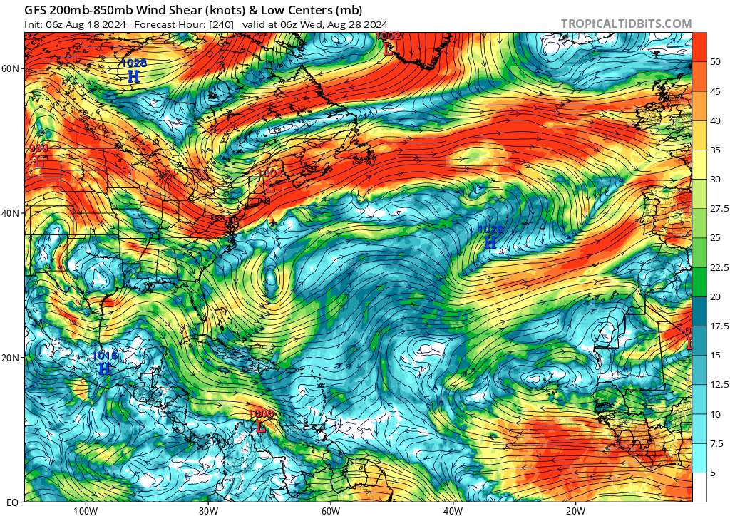
Not a favorable look on the long-range GFS as we head towards the climo peak across the Western Atlantic, Gulf, and Caribbean with widespread westerly wind shear, in fact almost looks like the GFS thinks we are in an El Nino. That said, we know these models beyond about a week and sometimes even less can be rather poor in forecasting tropical cyclone genesis as others have noted:

Image
0 likes   

User avatar
Teban54
Category 5
Category 5
Posts: 3168
Joined: Sat May 19, 2018 1:19 pm

Re: 2024 Global Model Runs Discussion (Out thru day 16)

#943 Postby Teban54 » Sun Aug 18, 2024 9:49 am

0 likes   

WeatherBoy2000
Category 1
Category 1
Posts: 280
Joined: Mon Apr 10, 2023 9:29 am

Re: 2024 Global Model Runs Discussion (Out thru day 16)

#944 Postby WeatherBoy2000 » Sun Aug 18, 2024 9:49 am

al78 wrote:
wxman57 wrote:Having to look for the odd ensemble member to identify development shows just how unfavorable the environment is. To reach 25 named storms, we'd need to see an explosion of storms the next 3 months that we've never seen in the past. Sub-20 looks quite likely. My 17/8/4 isn't looking too bad in our office contest, though I'm hoping for even less activity. Taking another comp day off tomorrow and probably Friday. Enjoying the break in storms.


It is a bit ominous for Atlantic activity that the east Pacific has now flared up with four areas of potential development over the next week. Normally the Atlantic and east Pacific basins are in anti-phase which implies not much happening in the Atlantic in the short term at least. I'm starting to wonder if this is going to be another weather trolling year where tropical cyclone behaviour completely defies the climatology signals that have worked over the last 60 years at least.


I wonder if the record-breaking warm Atlantic ssts don't stand out as much atmospherically when like 95% of the world's oceans are well above average. This line of thinking is similar to that of what made the Atlantic perform so much better in light of a strong el nino last year, the strong temp contrast between the Atlantic and enso like you'd usually see with a strong el nino wasn't there. I think if this year really flounders then there should be deeper discussions about how AGW is assuredly messing with our conventional understanding of TC activity. 2024 would mark the third year in a row where the Atlantic doesn't behave as expected from an enso standpoint. Not saying it's going to happen, I'm just putting it out there.

In any case, I think it'll be difficult not to meet the bare minimum for hyperactivity because we're already 50ish ace prior to August 20th. We only need an additional 110 ace to get there.
2 likes   

User avatar
DorkyMcDorkface
Category 3
Category 3
Posts: 820
Age: 27
Joined: Mon Sep 30, 2019 1:32 pm
Location: Mid-Atlantic

Re: 2024 Global Model Runs Discussion (Out thru day 16)

#945 Postby DorkyMcDorkface » Sun Aug 18, 2024 10:00 am

Despite most of the guidance still coming in rather quiet, I still fail to see any cause for panic when we're well above average in virtually every metric (ACE in particular, which is arguably the most important of all). And before someone suggests looking at the season without Beryl, you can't just arbitrarily omit a storm that likely would not have formed in any other year. I maintain that Beryl was a harbinger for the potential in the Atlantic this year.

Perhaps we won't reach/surpass the 20 NS mark, but ACE-wise we basically just need an average season from here on out to reach the hyperactive threshold. I know expectations are at an all-time high this year given the indicators leading up to this point, but it really is amazing how we go through this same song and dance every year regarding August lulls :lol:
7 likes   
Please note the thougths expressed by this account are solely those of the user and are from a hobbyist perspective. For more comprehensive analysis, consult an actual professional meteorologist or meteorology agency.


Floyd 1999 | Isabel 2003 | Hanna 2008 | Irene 2011 | Sandy 2012 | Isaias 2020

al78
Professional-Met
Professional-Met
Posts: 326
Joined: Thu Nov 01, 2018 12:20 pm

Re: 2024 Global Model Runs Discussion (Out thru day 16)

#946 Postby al78 » Sun Aug 18, 2024 11:07 am

WeatherBoy2000 wrote:
al78 wrote:
wxman57 wrote:Having to look for the odd ensemble member to identify development shows just how unfavorable the environment is. To reach 25 named storms, we'd need to see an explosion of storms the next 3 months that we've never seen in the past. Sub-20 looks quite likely. My 17/8/4 isn't looking too bad in our office contest, though I'm hoping for even less activity. Taking another comp day off tomorrow and probably Friday. Enjoying the break in storms.


It is a bit ominous for Atlantic activity that the east Pacific has now flared up with four areas of potential development over the next week. Normally the Atlantic and east Pacific basins are in anti-phase which implies not much happening in the Atlantic in the short term at least. I'm starting to wonder if this is going to be another weather trolling year where tropical cyclone behaviour completely defies the climatology signals that have worked over the last 60 years at least.


I wonder if the record-breaking warm Atlantic ssts don't stand out as much atmospherically when like 95% of the world's oceans are well above average. This line of thinking is similar to that of what made the Atlantic perform so much better in light of a strong el nino last year, the strong temp contrast between the Atlantic and enso like you'd usually see with a strong el nino wasn't there. I think if this year really flounders then there should be deeper discussions about how AGW is assuredly messing with our conventional understanding of TC activity. 2024 would mark the third year in a row where the Atlantic doesn't behave as expected from an enso standpoint. Not saying it's going to happen, I'm just putting it out there.

In any case, I think it'll be difficult not to meet the bare minimum for hyperactivity because we're already 50ish ace prior to August 20th. We only need an additional 110 ace to get there.


Normally it is the difference in SSTs between Nino 34 and the Caribbean Sea and the resultant perturbations to the Walker circulation which enhance or suppress Atlantic tropical cyclone activity through enhancement/suppression of low level trade winds and similar for upper-level westerlies. TSR uses this in its quantitative statistical prediction model. Last year was very active despite a moderate El Nino because, as you say, extremely warm SSTs in the Atlantic offset the effect of El Nino. It is different this year because cold-neutral or weak La Nina conditions should act in cooperation with very warm tropical Atlantic/Caribbean Sea SSTs in perturbing the Walker circulation to favour enhanced activity. It is too early to claim the seasonal forecasts are busting as we still have the bulk of the season to come, but given we are approaching the third week of August, I would have expected to see something on the NHC tropical weather outlook around now, as hyperactive seasons that had modest early season activity tended to get going around now.
4 likes   

Stormlover70
Tropical Storm
Tropical Storm
Posts: 167
Age: 55
Joined: Fri Jun 21, 2024 5:31 am
Location: New port richey

Re: 2024 Global Model Runs Discussion (Out thru day 16)

#947 Postby Stormlover70 » Sun Aug 18, 2024 11:41 am

SAL seems to be surging. Time will tell if it affects the MDR.
0 likes   

otowntiger
Category 5
Category 5
Posts: 1921
Joined: Tue Aug 31, 2004 7:06 pm

Re: 2024 Global Model Runs Discussion (Out thru day 16)

#948 Postby otowntiger » Sun Aug 18, 2024 11:49 am

al78 wrote:
wxman57 wrote:Having to look for the odd ensemble member to identify development shows just how unfavorable the environment is. To reach 25 named storms, we'd need to see an explosion of storms the next 3 months that we've never seen in the past. Sub-20 looks quite likely. My 17/8/4 isn't looking too bad in our office contest, though I'm hoping for even less activity. Taking another comp day off tomorrow and probably Friday. Enjoying the break in storms.


It is a bit ominous for Atlantic activity that the east Pacific has now flared up with four areas of potential development over the next week. Normally the Atlantic and east Pacific basins are in anti-phase which implies not much happening in the Atlantic in the short term at least. I'm starting to wonder if this is going to be another weather trolling year where tropical cyclone behaviour completely defies the climatology signals that have worked over the last 60 years at least.
I’m sure you mean ‘ominous’ in the good way, lol! As in bad for hurricane development but good in that hurricane development will be or is being suppressed in the western Atlantic basin, right?
1 likes   

TomballEd
Category 2
Category 2
Posts: 584
Age: 61
Joined: Wed Aug 16, 2023 4:52 pm
Location: Spring/Klein area, not Tomball

Re: 2024 Global Model Runs Discussion (Out thru day 16)

#949 Postby TomballEd » Sun Aug 18, 2024 12:39 pm

GFS brings several nice looking waves off Africa, which all weaken and die. Day 7 and Day 10 waves look impressive. Easterly shear isn't their friend. I suspect some ensembles members will show some development with both. (I can see hour 180, and yes, nothing strong, but there are members for both)

Yesterday's Euro weeklies suggest things pick up after September 2nd. I could be wrong, of course, but August probably doesn't get an F storm.

Less scientific, HL&P, 20 years ago, trimmed trees near powerlines every spring, to minimize outages from severe storms and tropical cyclones. CenterPoint, what was left after Reliant was split off, I never saw a crew. Now, I am finally seeing crews trimming trees. Barn door and horses, the Western Gulf is now safe.

The next HGX hurricane will come the year CenterPoint stops caring about tree limbs over powerlines. That is not scientific, it is more like empirical with a very short data set.
0 likes   

BIFF_THE_UNRULY
Tropical Storm
Tropical Storm
Posts: 143
Joined: Fri Jun 28, 2024 2:12 pm

Re: 2024 Global Model Runs Discussion (Out thru day 16)

#950 Postby BIFF_THE_UNRULY » Sun Aug 18, 2024 12:48 pm

God the water is hot. Hope this pattern hold. The florida waters are jacuzzi temp right now. Thankfully nothing for certain on the models spinning things up
0 likes   

al78
Professional-Met
Professional-Met
Posts: 326
Joined: Thu Nov 01, 2018 12:20 pm

Re: 2024 Global Model Runs Discussion (Out thru day 16)

#951 Postby al78 » Sun Aug 18, 2024 12:49 pm

otowntiger wrote:
al78 wrote:
wxman57 wrote:Having to look for the odd ensemble member to identify development shows just how unfavorable the environment is. To reach 25 named storms, we'd need to see an explosion of storms the next 3 months that we've never seen in the past. Sub-20 looks quite likely. My 17/8/4 isn't looking too bad in our office contest, though I'm hoping for even less activity. Taking another comp day off tomorrow and probably Friday. Enjoying the break in storms.


It is a bit ominous for Atlantic activity that the east Pacific has now flared up with four areas of potential development over the next week. Normally the Atlantic and east Pacific basins are in anti-phase which implies not much happening in the Atlantic in the short term at least. I'm starting to wonder if this is going to be another weather trolling year where tropical cyclone behaviour completely defies the climatology signals that have worked over the last 60 years at least.
I’m sure you mean ‘ominous’ in the good way, lol! As in bad for hurricane development but good in that hurricane development will be or is being suppressed in the western Atlantic basin, right?


Yes I meant "ominous" from the perspective of the Atlantic hurricane season ambitions to finish on the podium of most active seasons, not ominous from the human/monetary impacts perspective.
3 likes   

User avatar
Blown Away
S2K Supporter
S2K Supporter
Posts: 10140
Joined: Wed May 26, 2004 6:17 am

Re: 2024 Global Model Runs Discussion (Out thru day 16)

#952 Postby Blown Away » Sun Aug 18, 2024 1:34 pm

I’m a believer in the latter part of August atmospheric “switch” that ignites the hurricane season… But from a models perspective, they are 6-7 days from peak season now and really nothing except for a few strong TW’s…
2 likes   
Hurricane Eye Experience: David 79, Irene 99, Frances 04, Jeanne 04, Wilma 05... EYE COMING MY WAY IN 2024…
Hurricane Brush Experience: Andrew 92, Erin 95, Floyd 99, Matthew 16, Irma 17, Ian 22, Nicole 22…

MarioProtVI
Category 4
Category 4
Posts: 932
Age: 23
Joined: Sun Sep 29, 2019 7:33 pm
Location: New Jersey

Re: 2024 Global Model Runs Discussion (Out thru day 16)

#953 Postby MarioProtVI » Sun Aug 18, 2024 1:44 pm

Blown Away wrote:I’m a believer in the latter part of August atmospheric “switch” that ignites the hurricane season… But from a models perspective, they are 6-7 days from peak season now and really nothing except for a few strong TW’s…

They’ve been very poorly handling TWs this year and only seem to catch onto signals only 3-4 days out.
3 likes   

Stratton23
Category 5
Category 5
Posts: 2370
Joined: Fri Jul 21, 2023 10:59 pm
Location: Katy, Tx

Re: 2024 Global Model Runs Discussion (Out thru day 16)

#954 Postby Stratton23 » Sun Aug 18, 2024 1:55 pm

Blown Away id be very careful aboit looking at OP models in the long range, they are not seeing this flip well at all, all of the ensembles have a much different picture for the basin compared to the operational models
2 likes   

otowntiger
Category 5
Category 5
Posts: 1921
Joined: Tue Aug 31, 2004 7:06 pm

Re: 2024 Global Model Runs Discussion (Out thru day 16)

#955 Postby otowntiger » Sun Aug 18, 2024 2:04 pm

Blown Away wrote:I’m a believer in the latter part of August atmospheric “switch” that ignites the hurricane season… But from a models perspective, they are 6-7 days from peak season now and really nothing except for a few strong TW’s…
yep, and in a ‘normal’ season this would be surprising but even more so in a season that so many experts were predicting not just an active season, not just a hyper active season but a record breaking season. It all just goes to show you that nature can keep the best prognosticators guessing. It’s obviously about way more than hot water, LaNina MJO, etc. I’m beginning to think there are even as of yet unknown factors at play.
0 likes   

Stratton23
Category 5
Category 5
Posts: 2370
Joined: Fri Jul 21, 2023 10:59 pm
Location: Katy, Tx

Re: 2024 Global Model Runs Discussion (Out thru day 16)

#956 Postby Stratton23 » Sun Aug 18, 2024 2:15 pm

its not unknown factors, the waves are simply coming off at a latitude where dry- stable air lurks which kills these waves,thats going to be changing soon when the ITCZ shifts back south, the switch is coming, its no longer an “ IF” its when, because it is coming for sure
0 likes   

User avatar
MGC
S2K Supporter
S2K Supporter
Posts: 5885
Joined: Sun Mar 23, 2003 9:05 pm
Location: Pass Christian MS, or what is left.

Re: 2024 Global Model Runs Discussion (Out thru day 16)

#957 Postby MGC » Sun Aug 18, 2024 2:18 pm

All one has to do is look at the mid and low level water vapor satellite images. Tons of dry air across the basin. Models are quite for the next week, perhaps something could pop up? Remainder of season needs to be hyperactive in order to achieve some of the lofty numbers some have predicted. Warm water is just one part of the equation. Perhaps September and October will be different, but I hope not......MGC
0 likes   

User avatar
skyline385
Category 5
Category 5
Posts: 2728
Age: 34
Joined: Wed Aug 26, 2020 11:15 pm
Location: Houston TX

Re: 2024 Global Model Runs Discussion (Out thru day 16)

#958 Postby skyline385 » Sun Aug 18, 2024 2:22 pm

12z EPS is back with the NATL, the 0z was likely an anomaly and I wanted to see if 12z confirmed it which it didnt and considering switch flip is approaching, it should be safe to toss out that run for now.

Image

Image

Similar members on 12z GEFS

Image
3 likes   

TomballEd
Category 2
Category 2
Posts: 584
Age: 61
Joined: Wed Aug 16, 2023 4:52 pm
Location: Spring/Klein area, not Tomball

Re: 2024 Global Model Runs Discussion (Out thru day 16)

#959 Postby TomballEd » Sun Aug 18, 2024 2:39 pm

skyline385 wrote:12z EPS is back with the NATL, the 0z was likely an anomaly and I wanted to see if 12z confirmed it which it didnt and considering switch flip is approaching, it should be safe to toss out that run for now.

https://i.imgur.com/xWsxzaw.gif

https://i.imgur.com/S2PblSJ.png


If random members are popping random storms all over the basin, and many of the 'storms' struggle to get below 1010 mb, than the 50 Euro ensembles aren't really screaming the switch will be thrown soon. At best, conditions will get less hostile in 2 weeks. GFS and Canadian ensembles show shear going from extremely unfavorable to neutral, which this time of year means not terrible. I suspect this is why the Euro weeklies wait until September to start showing TCs.
Image
0 likes   

User avatar
skyline385
Category 5
Category 5
Posts: 2728
Age: 34
Joined: Wed Aug 26, 2020 11:15 pm
Location: Houston TX

Re: 2024 Global Model Runs Discussion (Out thru day 16)

#960 Postby skyline385 » Sun Aug 18, 2024 2:43 pm

TomballEd wrote:
skyline385 wrote:12z EPS is back with the NATL, the 0z was likely an anomaly and I wanted to see if 12z confirmed it which it didnt and considering switch flip is approaching, it should be safe to toss out that run for now.

https://i.imgur.com/xWsxzaw.gif

https://i.imgur.com/S2PblSJ.png


If random members are popping random storms all over the basin, and many of the 'storms' struggle to get below 1010 mb, than the 50 Euro ensembles aren't really screaming the switch will be thrown soon. At best, conditions will get less hostile in 2 weeks. GFS and Canadian ensembles show shear going from extremely unfavorable to neutral, which this time of year means not terrible. I suspect this is why the Euro weeklies wait until September to start showing TCs.
https://i.giphy.com/media/v1.Y2lkPTc5MGI3NjExbHkza2NxNjd5azJ3ZWh4MXBxYmRpdG1zZWUwZXB4MWJpOWl5NzNqMCZlcD12MV9pbnRlcm5hbF9naWZfYnlfaWQmY3Q9Zw/k4oq5dRqkulzo9YP1i/giphy.gif


Conditions near switch flip are generally volatile and change very quickly which is models always struggle to catch it. They show some activity and then as the date approaches, will all light up. Remember these are numerical models which can only forecast based on current conditions, that's why every year they suddenly light up as the switch flips. Personally, I would not put too much faith into shear plots as sign that switch flip is not near because that is just running off current conditions for initialization.
2 likes   


Return to “Talkin' Tropics”

Who is online

Users browsing this forum: Google [Bot], Google Adsense [Bot], MadaTheConquistador and 210 guests