The EURO gives a small boost to Caribbean area.
Global Model Runs for W.Caribbean Early Season Development
Moderator: S2k Moderators
Forum rules

The posts in this forum are NOT official forecasts and should not be used as such. They are just the opinion of the poster and may or may not be backed by sound meteorological data. They are NOT endorsed by any professional institution or STORM2K. For official information, please refer to products from the National Hurricane Center and National Weather Service.


-
Aric Dunn
- Category 5

- Posts: 21238
- Age: 43
- Joined: Sun Sep 19, 2004 9:58 pm
- Location: Ready for the Chase.
- Contact:
Re: Global Model Runs for W.Caribbean Early Season Development
not that its worth much but the nam has switch from the pacific to the SW carrib ..

0 likes

-
Aric Dunn
- Category 5
- Posts: 21238
- Age: 43
- Joined: Sun Sep 19, 2004 9:58 pm
- Location: Ready for the Chase.
- Contact:
Re:
KWT wrote:Yep Aric its really uncertain what will happen. Current sat.pics certainly would favor a EPAC system but it has to be said in to convergence and voricity argueably would favor the Sw Caribbean, it just needs something to set it off, a spark?
Maybe a happy little tropical wave approaching lol ..

0 likes
-
MiamiensisWx
Re: Global Model Runs for W.Caribbean Early Season Development
This is not an official forecast or prognosis; it is my personal thoughts on the current situation. Always rely on the TPC and NWS for official data.
Bottom line: "The following post is NOT an official forecast and should not be used as such. It is just the opinion of the poster and may or may not be backed by sound meteorological data. It is NOT endorsed by any professional institution including storm2k.org. For official information please refer to the NHC and NWS products."
Currently, there is a very complex and uncertain battle occurring over the extreme eastern Pacific and southern Caribbean basin, and it will likely be influenced by the evolution of the upper air pattern and low level environment over the next 24 to 48 hours. The most well defined mid-level circulation is evident over extreme eastern Pacific and along western Central America. This is a positive for possible EPAC cyclogenesis. However, it is still entwined with the broad surface trough that extends into the southern Caribbean, and it is still experiencing the resulting effects of upper level westerly shear. Although a surface low is present in the eastern Pacific, there are no signs of a low level circulation in the basin. If the EPAC surface low does not separate from the expansive surface trough over the next 24 to 48 hours, it is very likely that the southern Caribbean will serve as the focal point of cyclogenesis. In fact, there are additional signs that support the Caribbean instead of the EPAC. An upper level ridge will slowly expand over the vicinity during the next 24 to 36 hours, while a very close tropical wave axis and low level convergence line over NW South America will enter the southern Caribbean. The wave axis has remained defined overnight. This will aid lifting mechanisms for convection in the immediate area and support the development of a mesoscale convective system via cyclogenesis. The aforementioned moisture plume will also enter this region. Overall, the region of development (EPAC vs. S Caribbean basin) will likely be decided soon, and the region of the best low level inflow will influence it. I think the EPAC situation is a short lived distraction, while the S Caribbean will eventually win over the next few days. Alberto 2006 is a very decent analog for this system's genesis and early life span.
http://www.ssd.noaa.gov/goes/east/watl/loop-vis.html
The fact that the EPAC surface low is failing to detatch from the surface trough is quickly becoming its worst enemy and the S Caribbean's ally!
Last edited by MiamiensisWx on Tue May 27, 2008 3:38 pm, edited 2 times in total.
0 likes


-
gatorcane

- S2K Supporter

- Posts: 23703
- Age: 47
- Joined: Sun Mar 13, 2005 3:54 pm
- Location: Boca Raton, FL
Re: Global Model Runs for W.Caribbean Early Season Development
MiamiensisWx wrote:This is not an official forecast or prognosis; it is my personal thoughts on the current situation. Always rely on the TPC and NWS for official data.
Bottom line: "The following post is NOT an official forecast and should not be used as such. It is just the opinion of the poster and may or may not be backed by sound meteorological data. It is NOT endorsed by any professional institution including storm2k.org. For official information please refer to the NHC and NWS products."
Currently, there is a very complex and uncertain battle occurring over the extreme eastern Pacific and southern Caribbean basin, and it will likely be influenced by the evolution of the upper air pattern and low level environment over the next 24 to 48 hours. The most well defined mid-level circulation is evident over extreme eastern Pacific and along western Central America. This is a positive for possible EPAC cyclogenesis. However, it is still entwined with the broad surface trough that extends into the southern Caribbean, and it is still experiencing the resulting effects of upper level westerly shear. Although a surface low is present in the eastern Pacific, there are no signs of a low level circulation in the basin. If the EPAC surface low does not separate from the expansive surface trough over the next 24 to 48 hours, it is very likely that the southern Caribbean will serve as the focal point of cyclogenesis. In fact, there are additional signs that support the Caribbean instead of the EPAC. An upper level ridge will slowly expand over the vicinity during the next 24 to 36 hours, while a very close tropical wave axis and low level convergence line over NW South America will enter the southern Caribbean. The wave axis has remained defined overnight. This will aid lifting mechanisms for convection in the immediate area and support the development of a mesoscale convective system via cyclogenesis. The aforementioned moisture plume will also enter this region. Overall, the region of development (EPAC vs. S Caribbean basin) will likely be decided soon, and the region of the best low level inflow will influence it. I think the EPAC situation is a short lived distraction, while the S Caribbean will eventually win over the next few days. Alberto 2006 is a very decent analog for this system's genesis and early life span.
http://www.ssd.noaa.gov/goes/east/watl/loop-vis.html
The fact that the EPAC surface low is failing to detatch from the surface trough is quickly becoming its worst enemy and the S Caribbean's ally!
MiamiensisWx thanks for the detailed analysis. From the visible loop link you provided, it certainly looks like the low in the EPAC is losing convection on the north side while the entire area is still being sheared off to the east and northeast. At the same time, the low seems to be pulling in dry air off of Central America so development, if any, in the EPAC should be slow to occur. The SW Caribbean area looks to be holding strong this afternoon and I have been watching a tropical wave axis that is about to emerge into the SW Caribbean convection later tonight. That *should* really get some convection going on the basin side of things.
0 likes
Well I totally agree with you MiamiensisWx, as I've said before the GFS did try to form an EPAC system but then quickly favors the SW Caribbean low. I think thats what will happen in this case. I wouldn't totally rule out a TD in the EPAC if it can just get a sustianed convective burst...however I do think the main show will be in about 4-5 days time as the area of voricity heads further north and away from that broad area of low pressure. That wave heading towards the region may be finally whats needed to kick off this system, as someone else said the convection has been holding pretty well down there for the last 24hrs, if it can keep this up don't be surprised if we end up still getting a invest from that area.
0 likes
-
gatorcane
- S2K Supporter
- Posts: 23703
- Age: 47
- Joined: Sun Mar 13, 2005 3:54 pm
- Location: Boca Raton, FL
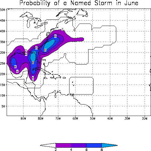
Here is historical strike probability provided by the Hurricane Research Division. If something were to form in the Western Caribbean in June, the Eastern GOM is more heavily favored based on climatology:
Last edited by gatorcane on Tue May 27, 2008 3:53 pm, edited 3 times in total.
0 likes
-
MiamiensisWx
Re: Re:
gatorcane wrote:Clearly the worst case for the SE US, especially Florida, is that we get a slack moving system over the open waters of the SW and Western Caribbean for a couple of days allowing this low to deepen and then the low eventually finds a weakness in the ridge to the north which would eventually happen....but its way too uncertain at this time what will happen.
actually the GFS keeps sniffing out a weakness to drive whatever is in the Caribbean north and then eventually NE....I think it is picking up on a new system that will approach the Pacific NW and drive SE possibly eroding the ridge over Texas and the northern GOM.
...indeed!
12Z GUID CONTINUES TREND OF GRADUAL MOISTENING FROM SOUTH TO
NORTH...ESPEC SUN AND BEYOND. NO CHANGES NEEDED TO EXTENDED FORECAST
AT THIS TIME. PREV DISC...SAT-MON...XTD GUIDANCE FROM THE 00Z
GFS/ECM CONTINUES TO ADVERTISE A GRADUAL BREAKDOWN OF THE RIDGE
ALOFT COUPLED WITH A GRADUAL INCREASE IN MEAN LYR MOISTURE FROM
SOUTH TO NORTH...ASCD WITH BOTH THE RIDGE WEAKENING AND A BROAD
LOWERING OF SLP ACROSS THE WRN CARIB. TIMING OF THE NWD SPREAD OF
MOISTURE REMAINS PROBLEMATIC...AS THE SUITE OF SOLNS FROM GLBL MODEL
GUIDANCE CONTINUE TO OFFER VARYING SOLNS W/R/T DEVELOPMENT
(TIMING/STRENGTH/MOVEMENT) OF A CARIB SFC LOW. OVERALL ...THE LATEST
ROUND OF SOLNS APPEAR TO BE A TAD SLOWER/MORE SUPPRESSED WITH THE
MOISTURE INCREASE...AND AS SUCH HAVE TRIMMED BACK POPS BY ABOUT 10%
FOR THIS WEEKEND...BUT EVENTUALLY REACHING 40% BY MON PER PREV
FCSTS. ONSHORE FLOW NOT PROGGED TO FRESHEN AS MUCH AS PREVIOUS
RUNS...SO HAVE TRIMMED BACK NOCTURNAL MARINE COASTAL SHRA TO SOUTH
OF THE CAPE.
NWS Melbourne AFD
0 likes
-
cycloneye

- Admin

- Posts: 148741
- Age: 69
- Joined: Thu Oct 10, 2002 10:54 am
- Location: San Juan, Puerto Rico
Re: Global Model Runs for W.Caribbean Early Season Development
HPC Discussion of Caribbean Area:
THE BROAD CYCLONIC CIRCULATION OVER THE SOUTHERN CARIBBEAN IS
DRAWING THE ITCZ NORTH ACROSS PANAMA TO THE SOUTHERN
CARIBBEAN/NORTHERN COLOMBIA...WHERE IT WILL PERSIST DURING THE
NEXT 48-60 HRS. SOUTHWARD MODULATION OF THE ITCZ IS POSSIBLE BY
72-84 HRS. MEANWHILE...THIS IS TO ENHANCE CONVECTION ACROSS
NORTHERN COLOMBIA/NORTHWEST VENEZUELA... WITH DAILY MAXIMA OF
25-50MM EXPECTED THROUGH 60 HRS. A SLIGHT DECREASE IN ACTIVITY IS
EXPECTED AT 60-84 HRS...WITH MAXIMA OF 20-35MM. ACROSS EJE
CAFETERO IN WESTERN COLOMBIA WE ARE EXPECTING DAILY MAXIMA OF
20-35MM...WITH MOST INTENSE CONVECTION TO BUILD/DEVELOP OF THE
COASTAL WATERS. OVER COSTA RICA AND PANAMA...WE INITIALLY EXPECT
MAXIMA OF 40-80MM. AS THE LOW LEVEL CYCLONE DEVELOPS OFF THE COAST
OF NICARAGUA...WE EXPECT A SURGE IN ACTIVITY ACROSS COSTA
RICA-SOUTHERN NICARAGUA...WHERE MAXIMA WILL PEAK AT 75-125MM.
HEAVY RAINS WILL EXPAND ACROSS EL SALVADOR-SOUTHERN HONDURAS BY
48-72 HRS...WHERE WE EXPECT MAXIMA OF 40-80MM. LOCALLY HIGHER
AMOUNTS ARE QUITE LIKELY DUE TO TOPOGRAPHICAL FORCING.
ADDITIONALLY...AS THE CYCLONIC CIRCULATION BECOMES BETTER
ORGANIZED...ALSO EXPECT AN INCREASE IN CONVECTION ACROSS NORTHWEST
HONDURAS-CENTRAL GUATEMALA AND SOUTHERN BELIZE...WHERE WE EXPECT
MAXIMA OF 25-50MM/DAY BY THE END OF THE PERIOD.
http://www.hpc.ncep.noaa.gov/discussions/fxca20.html
0 likes
Interesting gatorcane though as I said much depends on where it forms because if it develops too far west then no direction is really favored in the first 15 days of June, however a little further east and a Florida or Cuba strike becomes far more likely to occur.
So thats key IF it develops at all.
So thats key IF it develops at all.
0 likes
-
MiamiensisWx
-
Extremeweatherguy

- Category 5
- Posts: 11095
- Joined: Mon Oct 10, 2005 8:13 pm
- Location: Florida

Who is online
Users browsing this forum: No registered users and 79 guests