There will be another chance for something to develop later this month.
https://twitter.com/AndyHazelton/status/1532811170104725505
2022 Indicators (SSTs/SAL/MSLP/Shear/Steering/Instability) and >Day 16 Models
Moderator: S2k Moderators
Forum rules

The posts in this forum are NOT official forecasts and should not be used as such. They are just the opinion of the poster and may or may not be backed by sound meteorological data. They are NOT endorsed by any professional institution or STORM2K. For official information, please refer to products from the National Hurricane Center and National Weather Service.
-
cycloneye

- Admin

- Posts: 149727
- Age: 69
- Joined: Thu Oct 10, 2002 10:54 am
- Location: San Juan, Puerto Rico
Re: 2022 Indicators (SSTs/SAL/MSLP/Shear/Steering/Instability) and >Day 16 Models
1 likes
Visit the Caribbean-Central America Weather Thread where you can find at first post web cams,radars
and observations from Caribbean basin members Click Here
and observations from Caribbean basin members Click Here

Re: 2022 Indicators (SSTs/SAL/MSLP/Shear/Steering/Instability) and >Day 16 Models
aspen wrote:Steve wrote:AlphaToOmega wrote:
MJO/Kelvin wave dependence seems to be a mixed bag. It hurts active seasons with favorable base states (July and October 2021 were inactive largely because of the suppressive MJO), but it can help seasons with unfavorable base states. In a weak MJO season, a basin would be either favorable or unfavorable for development throughout the entire season (similar to 2020); in a strong MJO season, the basin would be favorable when and only when the MJO is centered at the basin (similar to 2021).
We recently rotated into Phase 8 and voila, Tropical Storm Alex should be classified today. It's too early to know how many systems will be MJO-indicated this season, but we'd be starting it off 1 out of 1. MJO is definitely something I've gotten more comfortable with the last few years.
I highly doubt we get TS Alex today. Maybe tomorrow at the earliest. It’s really not looking hot today.
If PTC-1 never becomes a named storm, when would the next window for development be (favorable MJO + CCKW)?
It's close. We have a spinning low pressure coming up out of the tropics which is similar to an early June type system. Whether it actually gets classified or not, it's pretty close and has the spin and characteristics of what you'd expect in a favorable MJO Phase. Maybe it waits until the coast of FL or possibly the SW Atlantic. We have about 3 days in Phase I per the consensus. But the Japanese model, which often is better than the rest at this, actually has the MJO dropping into Phase I instead of going into the circle and sticking around a few days in Phase I. So a week/10 days there could be something else coming up. It doesn't automatically mean development, but when you see it hitting 8-1-2-3 in sequence or particularly dropping into 2 or 3, those are often the phases when the big US threats come - and generally later in the summer of course.
0 likes
-
DorkyMcDorkface

- Category 5

- Posts: 1044
- Age: 28
- Joined: Mon Sep 30, 2019 1:32 pm
- Location: Mid-Atlantic
Re: 2022 Indicators (SSTs/SAL/MSLP/Shear/Steering/Instability) and >Day 16 Models
Well since our active PTC appears to be crashing and burning, we may as well look ahead for more opportunities for tropical development. Could maybe see more CAG activity later this month, then the ASW/WAM kicks in by July it appears:

7 likes
Please note the thoughts expressed by this account are solely those of the user and are from a hobbyist perspective. For more comprehensive analysis, consult an actual professional meteorologist or meteorological agency.
Floyd 1999 | Isabel 2003 | Hanna 2008 | Irene 2011 | Sandy 2012 | Isaias 2020
-
Category5Kaiju

- Category 5
- Posts: 4347
- Joined: Thu Dec 24, 2020 12:45 pm
- Location: Seattle during the summer, Phoenix during the winter
Re: 2022 Indicators (SSTs/SAL/MSLP/Shear/Steering/Instability) and >Day 16 Models
I'm gonna be frank here, for a June 5th official start of the 2022 hurricane season, that's not terribly late for an on-time start compared to past seasons since 1995. Of those seasons that did not have a pre-season storm, only 1995 had its first storm form earlier (June 2). 2022 ties 2013 and 2001 for the June 5 start date.
Now it would have almost certainly have been fun to watch if PTC1 remained PTC1 and then see the comments flood in about how we would have to wait until possibly late June or July for Alex to happen
Now it would have almost certainly have been fun to watch if PTC1 remained PTC1 and then see the comments flood in about how we would have to wait until possibly late June or July for Alex to happen
4 likes
Unless explicitly stated, all information in my posts is based on my own opinions and observations. Tropical storms and hurricanes can be extremely dangerous. Refer to an accredited weather research agency or meteorologist if you need to make serious decisions regarding an approaching storm.

Re: 2022 Indicators (SSTs/SAL/MSLP/Shear/Steering/Instability) and >Day 16 Models
Category5Kaiju wrote:I'm gonna be frank here, for a June 5th official start of the 2022 hurricane season, that's not terribly late for an on-time start compared to past seasons since 1995. Of those seasons that did not have a pre-season storm, only 1995 had its first storm form earlier (June 2). 2022 ties 2013 and 2001 for the June 5 start date.
Now it would have almost certainly have been fun to watch if PTC1 remained PTC1 and then see the comments flood in about how we would have to wait until possibly late June or July for Alex to happen
Not gonna lie, I was kind of hoping PTC1 would remain a PTC, and the potential storm that's being discussed in the model thread now takes the name Alex and becomes Alex 2010 redux.
2 likes
TC naming lists: retirements and intensity
Most aggressive Advisory #1's in North Atlantic (cr. kevin for starting the list)
Most aggressive Advisory #1's in North Atlantic (cr. kevin for starting the list)
-
skyline385

- Category 5
- Posts: 2728
- Age: 35
- Joined: Wed Aug 26, 2020 11:15 pm
- Location: Houston TX
Re: 2022 Indicators (SSTs/SAL/MSLP/Shear/Steering/Instability) and >Day 16 Models
Category5Kaiju wrote:I'm gonna be frank here, for a June 5th official start of the 2022 hurricane season, that's not terribly late for an on-time start compared to past seasons since 1995. Of those seasons that did not have a pre-season storm, only 1995 had its first storm form earlier (June 2). 2022 ties 2013 and 2001 for the June 5 start date.
Now it would have almost certainly have been fun to watch if PTC1 remained PTC1 and then see the comments flood in about how we would have to wait until possibly late June or July for Alex to happen
I was hoping Alex to be a bit further north for the eventual 2013 analogs lol
2 likes


Re: 2022 Indicators (SSTs/SAL/MSLP/Shear/Steering/Instability) and >Day 16 Models
Category5Kaiju wrote:I'm gonna be frank here, for a June 5th official start of the 2022 hurricane season, that's not terribly late for an on-time start compared to past seasons since 1995. Of those seasons that did not have a pre-season storm, only 1995 had its first storm form earlier (June 2). 2022 ties 2013 and 2001 for the June 5 start date.
Now it would have almost certainly have been fun to watch if PTC1 remained PTC1 and then see the comments flood in about how we would have to wait until possibly late June or July for Alex to happen
Glad we'll get to avoid most of the "no early Alex? BUST!" type of comment now
2 likes
-
Kingarabian

- S2K Supporter

- Posts: 16379
- Joined: Sat Aug 08, 2009 3:06 am
- Location: Honolulu, Hawaii
Re: 2022 Indicators (SSTs/SAL/MSLP/Shear/Steering/Instability) and >Day 16 Models
CFS shows nearly three weeks of slow MDR trades starting around June 10.
Wonder if 2022 will break the trend of a 3rd year La Nina being slower than other La Nina's. It's usually years where -ENSO immediately follows a +ENSO year that leads to the most destructive Atlantic hurricane seasons.
Wonder if 2022 will break the trend of a 3rd year La Nina being slower than other La Nina's. It's usually years where -ENSO immediately follows a +ENSO year that leads to the most destructive Atlantic hurricane seasons.
6 likes
RIP Kobe Bryant
-
tolakram
- Admin
- Posts: 20186
- Age: 62
- Joined: Sun Aug 27, 2006 8:23 pm
- Location: Florence, KY (name is Mark)
Re: 2022 Indicators (SSTs/SAL/MSLP/Shear/Steering/Instability) and >Day 16 Models
I feel like 'pattern change' years end up having the least shear. I know the atmosphere just flipped to la nina, at least that's what I've been reading. Is this the actual flip year and last year was kind of a fake la nina? fake = ocean temps said la nina but upper air did not?
0 likes
M a r k
- - - - -
Join us in chat: Storm2K Chatroom Invite. Android and IOS apps also available.
The posts in this forum are NOT official forecasts and should not be used as such. Posts are NOT endorsed by any professional institution or STORM2K.org. For official information and forecasts, please refer to NHC and NWS products.
-
AlphaToOmega
- Category 5
- Posts: 1448
- Joined: Sat Jun 26, 2021 10:51 am
- Location: Somewhere in Massachusetts
Re: 2022 Indicators (SSTs/SAL/MSLP/Shear/Steering/Instability) and >Day 16 Models
tolakram wrote:I feel like 'pattern change' years end up having the least shear. I know the atmosphere just flipped to la nina, at least that's what I've been reading. Is this the actual flip year and last year was kind of a fake la nina? fake = ocean temps said la nina but upper air did not?
The anomalous upper air pattern was likely caused by the Atlantic Nino, which undid much of the impacts of the La Nina last year. Still, upper-air VP patterns showed a very obvious La Nina pattern (rising air over Eastern Hemisphere + sinking air over Western Hemisphere = La Nina atmospheric pattern):
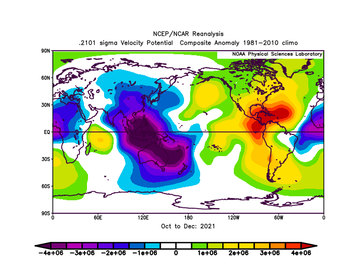
Last year was more of a 2007-esque La Nina than a "fake" one.
0 likes

Re: 2022 Indicators (SSTs/SAL/MSLP/Shear/Steering/Instability) and >Day 16 Models
Kingarabian wrote:CFS shows nearly three weeks of slow MDR trades starting around June 10.
Wonder if 2022 will break the trend of a 3rd year La Nina being slower than other La Nina's. It's usually years where -ENSO immediately follows a +ENSO year that leads to the most destructive Atlantic hurricane seasons.
So we could see another MDR warming phase starting next week?
2 likes
Irene '11 Sandy '12 Hermine '16 5/15/2018 Derecho Fay '20 Isaias '20 Elsa '21 Henri '21 Ida '21
I am only a meteorology enthusiast who knows a decent amount about tropical cyclones. Look to the professional mets, the NHC, or your local weather office for the best information.
I am only a meteorology enthusiast who knows a decent amount about tropical cyclones. Look to the professional mets, the NHC, or your local weather office for the best information.
-
SFLcane

- S2K Supporter
- Posts: 10281
- Age: 48
- Joined: Sat Jun 05, 2010 1:44 pm
- Location: Lake Worth Florida
Re: 2022 Indicators (SSTs/SAL/MSLP/Shear/Steering/Instability) and >Day 16 Models
Folks!! This is going to be an epic season. Get your sleep now. This is quite scary what I am seeing. 
4 likes
-
AlphaToOmega
- Category 5
- Posts: 1448
- Joined: Sat Jun 26, 2021 10:51 am
- Location: Somewhere in Massachusetts
Re: 2022 Indicators (SSTs/SAL/MSLP/Shear/Steering/Instability) and >Day 16 Models
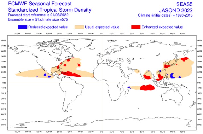
SFLcane wrote:Folks!! This is going to be an epic season. Get your sleep now. This is quite scary what I am seeing.
https://i.postimg.cc/xdySCnbN/05-B98-F16-D96-C-43-FE-AE23-AB6-EC61050-B3.jpg
According to this, the Antilles look busy.

3 likes
-
cycloneye
- Admin
- Posts: 149727
- Age: 69
- Joined: Thu Oct 10, 2002 10:54 am
- Location: San Juan, Puerto Rico
Re: 2022 Indicators (SSTs/SAL/MSLP/Shear/Steering/Instability) and >Day 16 Models
SFLcane wrote:Folks!! This is going to be an epic season. Get your sleep now. This is quite scary what I am seeing.
https://i.postimg.cc/xdySCnbN/05-B98-F16-D96-C-43-FE-AE23-AB6-EC61050-B3.jpg
Yikes, almost all the Lesser and Greater Antilles are in red.
0 likes
Visit the Caribbean-Central America Weather Thread where you can find at first post web cams,radars
and observations from Caribbean basin members Click Here
and observations from Caribbean basin members Click Here
-
Category5Kaiju
- Category 5
- Posts: 4347
- Joined: Thu Dec 24, 2020 12:45 pm
- Location: Seattle during the summer, Phoenix during the winter
Re: 2022 Indicators (SSTs/SAL/MSLP/Shear/Steering/Instability) and >Day 16 Models
Kingarabian wrote:CFS shows nearly three weeks of slow MDR trades starting around June 10.
Wonder if 2022 will break the trend of a 3rd year La Nina being slower than other La Nina's. It's usually years where -ENSO immediately follows a +ENSO year that leads to the most destructive Atlantic hurricane seasons.
I do think that this is a legitimate possibility. If anything, seems like conditions are even more favorable than last year
0 likes
Unless explicitly stated, all information in my posts is based on my own opinions and observations. Tropical storms and hurricanes can be extremely dangerous. Refer to an accredited weather research agency or meteorologist if you need to make serious decisions regarding an approaching storm.

-
DorkyMcDorkface
- Category 5
- Posts: 1044
- Age: 28
- Joined: Mon Sep 30, 2019 1:32 pm
- Location: Mid-Atlantic
Re: 2022 Indicators (SSTs/SAL/MSLP/Shear/Steering/Instability) and >Day 16 Models
Never seen the Euro SEAS5 this bullish before lol. Good lord...
3 likes
Please note the thoughts expressed by this account are solely those of the user and are from a hobbyist perspective. For more comprehensive analysis, consult an actual professional meteorologist or meteorological agency.
Floyd 1999 | Isabel 2003 | Hanna 2008 | Irene 2011 | Sandy 2012 | Isaias 2020
-
cycloneye
- Admin
- Posts: 149727
- Age: 69
- Joined: Thu Oct 10, 2002 10:54 am
- Location: San Juan, Puerto Rico
Re: 2022 Indicators (SSTs/SAL/MSLP/Shear/Steering/Instability) and >Day 16 Models
0 likes
Visit the Caribbean-Central America Weather Thread where you can find at first post web cams,radars
and observations from Caribbean basin members Click Here
and observations from Caribbean basin members Click Here
-
weeniepatrol

- Category 5
- Posts: 1345
- Joined: Sat Aug 22, 2020 5:30 pm
- Location: WA State

Who is online
Users browsing this forum: No registered users and 123 guests