Seasonal Indicators (Beyond Day 16): Instability / SST's / MSLP / Steering / Sal
Moderator: S2k Moderators
Forum rules

The posts in this forum are NOT official forecasts and should not be used as such. They are just the opinion of the poster and may or may not be backed by sound meteorological data. They are NOT endorsed by any professional institution or STORM2K. For official information, please refer to products from the National Hurricane Center and National Weather Service.
-
TheStormExpert
Re: Seasonal Indicators (Beyond Day 16): Instability / SST's / MSLP / Steering / Sal
Wxman57 did mention that the NW Caribbean was where he thought things would wake up first in the Atlantic.
0 likes
-
SFLcane

- S2K Supporter

- Posts: 10281
- Age: 48
- Joined: Sat Jun 05, 2010 1:44 pm
- Location: Lake Worth Florida
Re: Seasonal Indicators (Beyond Day 16): Instability / SST's / MSLP / Steering / Sal
Tempted to say this but the Caribbean,Gulf Bahamas region are open for business even the main development region to some extent. Once we get ride of this SAL "watch out ".

1 likes
-
TheStormExpert
Re: Seasonal Indicators (Beyond Day 16): Instability / SST's / MSLP / Steering / Sal
Yes shear has most definitely dropped to non-inhibiting levels towards tropical development.

Now all we need is for the SAL to decrease a good deal at least and instability should come up some though I still expect it to be below average in the Tropical Atlantic this season.

Now all we need is for the SAL to decrease a good deal at least and instability should come up some though I still expect it to be below average in the Tropical Atlantic this season.
1 likes

Re: Seasonal Indicators (Beyond Day 16): Instability / SST's / MSLP / Steering / Sal
That wave near Cape Verde is very large and is bringing moist air from the south up behind it. It might be a rather effective sacrificial wave.
2 likes


Re: Seasonal Indicators (Beyond Day 16): Instability / SST's / MSLP / Steering / Sal
RL3AO wrote:That wave near Cape Verde is very large and is bringing moist air from the south up behind it. It might be a rather effective sacrificial wave.
Is the SAL basically the only think preventing development at this point?
0 likes
The above post is not official and should not be used as such. It is the opinion of the poster and may or may not be backed by sound meteorological data. It is not endorsed by any professional institution or storm2k.org. For official information, please refer to the NHC and NWS products.
Re: Seasonal Indicators (Beyond Day 16): Instability / SST's / MSLP / Steering / Sal
Hammy wrote:RL3AO wrote:That wave near Cape Verde is very large and is bringing moist air from the south up behind it. It might be a rather effective sacrificial wave.
Is the SAL basically the only think preventing development at this point?
I don't think anything can develop east of 50W right now. Water is kinda cool and there is a bunch of sinking air. Any development in the next couple weeks will be near the islands or in Caribbean/Bahamas.
0 likes
-
TheStormExpert
Re: Seasonal Indicators (Beyond Day 16): Instability / SST's / MSLP / Steering / Sal


0 likes
-
gatorcane

- S2K Supporter
- Posts: 23708
- Age: 48
- Joined: Sun Mar 13, 2005 3:54 pm
- Location: Boca Raton, FL
Re: Seasonal Indicators (Beyond Day 16): Instability / SST's / MSLP / Steering / Sal
Hammy wrote:RL3AO wrote:That wave near Cape Verde is very large and is bringing moist air from the south up behind it. It might be a rather effective sacrificial wave.
Is the SAL basically the only think preventing development at this point?
Another thing is mid-level dry air. Even in 2013 I recall low shear across much of the Atlantic with warmer than normal SSTs but yet it was a below average season. This mid-level dry air is widespread across the Atlantic basin. Models out through a week do not show any improvement so waves just dry up and then once they enter Caribbean cannot develop due to shear. We would expect to see less mid-level dry air as we head into early August but my feeling is we may need to wait another 4-5 weeks to get a named system of tropical origin in the Atlantic.
1 likes


Re: Seasonal Indicators (Beyond Day 16): Instability / SST's / MSLP / Steering / Sal
gatorcane wrote:Hammy wrote:RL3AO wrote:That wave near Cape Verde is very large and is bringing moist air from the south up behind it. It might be a rather effective sacrificial wave.
Is the SAL basically the only think preventing development at this point?
Another thing is mid-level dry air. Even in 2013 I recall low shear across much of the Atlantic with warmer than normal SSTs but yet it was a below average season. This mid-level dry air is widespread across the Atlantic basin. Models out through a week do not show any improvement so waves just dry up and then once they enter Caribbean cannot develop due to shear. We would expect to see less mid-level dry air as we head into early August but my feeling is we may need to wait another 4-5 weeks to get a named system of tropical origin in the Atlantic.
Higher than normal pressures the cause? i see it in the drier than normal precipitation rates using July 1-12 reanalysis. Though not the extent it was in 2013.
0 likes
The above post and any post by Ntxw is NOT an official forecast and should not be used as such. It is just the opinion of the poster and may or may not be backed by sound meteorological data. It is NOT endorsed by any professional institution including Storm2k. For official information, please refer to NWS products.
Help support Storm2K!
-
TheStormExpert
Re: Seasonal Indicators (Beyond Day 16): Instability / SST's / MSLP / Steering / Sal

Like Wxman57 said, he is not seeing a big Cape Verde season coming but of more concern is the waves that can actually survive and track all the way to the Western Caribbean, Gulf of Mexico, or even off the SE U.S.(if the Bermuda High isn't too strong). This is where the real action will take place, and as we've seen years past those systems are far more likely to affect land.
Last edited by TheStormExpert on Thu Jul 14, 2016 9:08 pm, edited 1 time in total.
0 likes
Re: Seasonal Indicators (Beyond Day 16): Instability / SST's / MSLP / Steering / Sal
TheStormExpert wrote::uarrow: Mid-Level Dry Air at the moment is an issue, but of course there is so much Dry Stable Air/SAL out there at the moment so we will see if this changes in the coming weeks.
That's certainly true but mostly for the lower levels, SAL can be overcome with vigorous waves. Mid level dry air is more a product of sinking air.
1 likes
The above post and any post by Ntxw is NOT an official forecast and should not be used as such. It is just the opinion of the poster and may or may not be backed by sound meteorological data. It is NOT endorsed by any professional institution including Storm2k. For official information, please refer to NWS products.
Help support Storm2K!
Help support Storm2K!
-
ninel conde
Re: Seasonal Indicators (Beyond Day 16): Instability / SST's / MSLP / Steering / Sal
I dont expect july to be super active but if i were looking for aug/sept to be active i would expect at the very least to see waves survive across the atlantic with at least some convection. Going well past day 16 to next season its beginning to look like another very dry winter in cali with a big trof in the east. To see a break in this multi-year pattern i would expect first to see the drought in california to end. I should have realized this season when the super el nino didnt result in cali drought busting rain that something was wrong.
0 likes
-
tolakram
- Admin

- Posts: 20185
- Age: 62
- Joined: Sun Aug 27, 2006 8:23 pm
- Location: Florence, KY (name is Mark)
Re: Seasonal Indicators (Beyond Day 16): Instability / SST's / MSLP / Steering / Sal
ninel conde wrote:I dont expect july to be super active but if i were looking for aug/sept to be active i would expect at the very least to see waves survive across the atlantic with at least some convection. Going well past day 16 to next season its beginning to look like another very dry winter in cali with a big trof in the east. To see a break in this multi-year pattern i would expect first to see the drought in california to end. I should have realized this season when the super el nino didnt result in cali drought busting rain that something was wrong.
They are all surviving just fine and developing in the EPAC. Why do you claim waves are not surviving?
I don't think the 'big trof in the east' has as that big an influence on Atlantic and US weather patterns. As can be seen looking at archived weather maps the 'trof in the east' is a fairly regular feature.
0 likes
M a r k
- - - - -
Join us in chat: Storm2K Chatroom Invite. Android and IOS apps also available.
The posts in this forum are NOT official forecasts and should not be used as such. Posts are NOT endorsed by any professional institution or STORM2K.org. For official information and forecasts, please refer to NHC and NWS products.
-
tolakram
- Admin
- Posts: 20185
- Age: 62
- Joined: Sun Aug 27, 2006 8:23 pm
- Location: Florence, KY (name is Mark)
Re: Seasonal Indicators (Beyond Day 16): Instability / SST's / MSLP / Steering / Sal
CIMSS product loops.
All from this page: http://tropic.ssec.wisc.edu/real-time/salmain.php?&prod=truecol&time=
SAL: http://tropic.ssec.wisc.edu/real-time/s ... E5new.html
Mid-level Water Vapor: http://tropic.ssec.wisc.edu/real-time/s ... d5new.html
Upper-level Water Vapor: http://tropic.ssec.wisc.edu/real-time/s ... i5new.html
Sat loop: http://tropic.ssec.wisc.edu/real-time/s ... l5new.html
Mid-level Water Vapor: http://tropic.ssec.wisc.edu/real-time/s ... d5new.html
Upper-level Water Vapor: http://tropic.ssec.wisc.edu/real-time/s ... i5new.html
Sat loop: http://tropic.ssec.wisc.edu/real-time/s ... l5new.html
All from this page: http://tropic.ssec.wisc.edu/real-time/salmain.php?&prod=truecol&time=
0 likes
M a r k
- - - - -
Join us in chat: Storm2K Chatroom Invite. Android and IOS apps also available.
The posts in this forum are NOT official forecasts and should not be used as such. Posts are NOT endorsed by any professional institution or STORM2K.org. For official information and forecasts, please refer to NHC and NWS products.
- - - - -
Join us in chat: Storm2K Chatroom Invite. Android and IOS apps also available.
The posts in this forum are NOT official forecasts and should not be used as such. Posts are NOT endorsed by any professional institution or STORM2K.org. For official information and forecasts, please refer to NHC and NWS products.
-
srainhoutx

- S2K Supporter
- Posts: 6919
- Age: 68
- Joined: Sun Jan 14, 2007 11:34 am
- Location: Haywood County, NC
- Contact:
Re: Seasonal Indicators (Beyond Day 16): Instability / SST's / MSLP / Steering / Sal
I continue to see the GEFS Ensemble Members suggesting the possibility of TC Genesis across the NW Caribbean and the Gulf in the longer range. Both the 00Z and 06Z runs are indicating the potential of a more favorable pattern developing as we end July and begin August as mean sea level pressures lower and vorticity potential increases.
00Z:
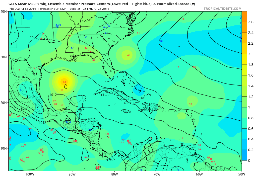
06Z
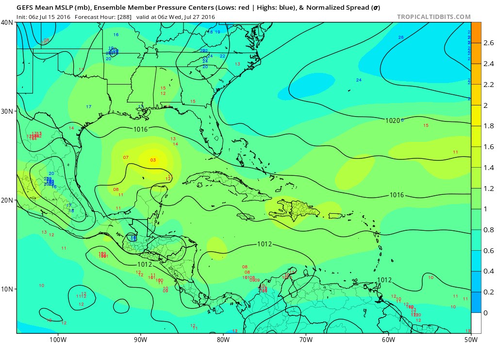
00Z:
06Z
0 likes
Carla/Alicia/Jerry(In The Eye)/Michelle/Charley/Ivan/Dennis/Katrina/Rita/Wilma/Ike/Harvey
Member: National Weather Association
Wx Infinity Forums
http://wxinfinity.com/index.php
Facebook.com/WeatherInfinity
Twitter @WeatherInfinity
Member: National Weather Association
Wx Infinity Forums
http://wxinfinity.com/index.php
Facebook.com/WeatherInfinity
Twitter @WeatherInfinity
-
TheStormExpert
Re: Seasonal Indicators (Beyond Day 16): Instability / SST's / MSLP / Steering / Sal
This was also posted in the ENSO Thread but I feel it could be something to discuss here while we wait for what the rest of the 2016 season has to offer.
What effects would a Neutral state ENSO have on the Atlantic when compared to a La Niña state ENSO?
https://twitter.com/philklotzbach/status/753945406514397184
What effects would a Neutral state ENSO have on the Atlantic when compared to a La Niña state ENSO?
https://twitter.com/philklotzbach/status/753945406514397184
0 likes
Re: Seasonal Indicators (Beyond Day 16): Instability / SST's / MSLP / Steering / Sal
It means local conditions and indices in the Atlantic will have bigger influences since there will be little outside influence. Weather patterns and preconditioning even more a player. The past two neutral seasons (2012 and 2013) were complete opposites. Volatile forecast.
0 likes
The above post and any post by Ntxw is NOT an official forecast and should not be used as such. It is just the opinion of the poster and may or may not be backed by sound meteorological data. It is NOT endorsed by any professional institution including Storm2k. For official information, please refer to NWS products.
Help support Storm2K!
Help support Storm2K!

Re: Seasonal Indicators (Beyond Day 16): Instability / SST's / MSLP / Steering / Sal
ninel conde wrote:I dont expect july to be super active but if i were looking for aug/sept to be active i would expect at the very least to see waves survive across the atlantic with at least some convection
I agree to a point, and I do believe that we will soon begin to see some far more impressive waves begin to roll off Africa somewhere in the 1-3 week time frame. The only exception I might take comes from recalling years where wave after wave rolled off the W. coast of Africa, just to dissapear as they entered repressed E. Atlantic conditions, or perhaps to seemingly dive SW. into a southward repressed ITCZ. However, that wasnt to say that those "pouches" of vorticity didn't re-emerge farther west where pressures might have been lower and the ITCZ bulged further north. Ironically, it could well be those systems that are unable to develop further east that might well reappear east of the Lesssor Antilles which might be cause for development of tropical systems that would have otherwise developed and possibly picked up by some mid Atlantic trough. These same repressed and 'under the radar" waves, might well be an increased cause of Caribbean, Mexican, and potentially U.S. landfalls as we move into the meat of the season, a few weeks from now.
0 likes
Andy D
(For official information, please refer to the NHC and NWS products.)
(For official information, please refer to the NHC and NWS products.)
-
tolakram
- Admin
- Posts: 20185
- Age: 62
- Joined: Sun Aug 27, 2006 8:23 pm
- Location: Florence, KY (name is Mark)
Re: Seasonal Indicators (Beyond Day 16): Instability / SST's / MSLP / Steering / Sal
0 likes
M a r k
- - - - -
Join us in chat: Storm2K Chatroom Invite. Android and IOS apps also available.
The posts in this forum are NOT official forecasts and should not be used as such. Posts are NOT endorsed by any professional institution or STORM2K.org. For official information and forecasts, please refer to NHC and NWS products.
- - - - -
Join us in chat: Storm2K Chatroom Invite. Android and IOS apps also available.
The posts in this forum are NOT official forecasts and should not be used as such. Posts are NOT endorsed by any professional institution or STORM2K.org. For official information and forecasts, please refer to NHC and NWS products.
-
hurricanehunter69
- Category 1

- Posts: 344
- Joined: Sun May 16, 2010 5:21 pm
- Location: New Orleans
Re: Seasonal Indicators (Beyond Day 16): Instability / SST's / MSLP / Steering / Sal
Maybe we can think of this wave in the far eastern Atlantic as a snow plow ( dry air/SAL plow). Or...the engine of the 2016 cape verde wave train? also...check out that cyclonic motion in the Gulf? http://www.ssd.noaa.gov/goes/east/tatl/flash-wv.html
0 likes
Who is online
Users browsing this forum: Europa non è lontana and 255 guests