
Inspired by the discussion of July MDR/Caribbean storms and their indication of an active hurricane season, I went back until 1980 and found eleven seasons with at least one named storm in this region and time: 2018 (Beryl), 2017 (Don), 2013 (Chantal and Dorian), 2008 (Bertha), 2005 (Dennis and Emily), 2003 (Claudette), 1998 (Alex), 1996 (Bertha and Cesar), 1995 (Chantal), 1990 (Arthur and Cesar), and 1989 (Barry and Dean). With the exception of 1990 and 2013, all of these were at least above-average seasons in terms of storms and ACE. The mean seasonal parameters of this sample are below.
—Named Storms: 16.1
—Hurricanes: 8.6
—Major Hurricanes: 3.6
—ACE: 161.20
There’s a very clear positive correlation between early MDR/Caribbean systems formed from AEWs and overall seasonal activity, with a couple of outliers. However, intensity and frequency do not indicate whether it will be either a normally active season or a hyperactive season. 2017 only had weak TS Don, but it ended up with 225 ACE, higher than 2008 despite having the long-tracking Cat 3 Hurricane Bertha in the MDR. The point is, if at least one storm forms in the MDR during July, it’s very likely the rest of the season will be active.
Another thing worth noting is that some of these seasons, including 2018, 2008, and 2005, had additional July hurricanes either in the Gulf (Dolly ‘08 and Cindy ‘05) or off the US East Coast (Chris ‘18). Also, there were several other seasons that had a lackluster July but later had an MDR/Caribbean system form prior to August 5th: 2016, 2012, 2006, 2000, and 1993. Some (but not all) ended up being above-average.
2020 Indicators: SST's / SAL / MSLP / Steering / Shear / Instability / Sat Images
Moderator: S2k Moderators
Forum rules

The posts in this forum are NOT official forecasts and should not be used as such. They are just the opinion of the poster and may or may not be backed by sound meteorological data. They are NOT endorsed by any professional institution or STORM2K. For official information, please refer to products from the National Hurricane Center and National Weather Service.
Re: 2020 Indicators: SST's / SAL / MSLP / Steering / Shear / Instability / Sat Images
8 likes
Irene '11 Sandy '12 Hermine '16 5/15/2018 Derecho Fay '20 Isaias '20 Elsa '21 Henri '21 Ida '21
I am only a meteorology enthusiast who knows a decent amount about tropical cyclones. Look to the professional mets, the NHC, or your local weather office for the best information.
I am only a meteorology enthusiast who knows a decent amount about tropical cyclones. Look to the professional mets, the NHC, or your local weather office for the best information.
-
SFLcane

- S2K Supporter

- Posts: 10281
- Age: 48
- Joined: Sat Jun 05, 2010 1:44 pm
- Location: Lake Worth Florida
Re: 2020 Indicators: SST's / SAL / MSLP / Steering / Shear / Instability / Sat Images
ScottNAtlanta wrote:I think there is a lot of missing the forest for the trees. Everyone is focused on what this model says will be JAS and that the High will be here not there. I'd say look at whats in front of you. Anomalously warm MDR with cooler than normal subtropics. Looking at the SST anomaly above, the cool anomalies run right to the coastal region in the subtropics. Cooler subtropics over warmer MDR is going to lower the pressures in the MDR if they continue, and I see no real reason this configuration will change all that dramatically in the next several months. So you will have higher pressures in the subtropics over the cooler anomalies and lower pressures in the deep tropics. The fact that cooler anomalies go right up to the coast doesn't lend well to an "all out to sea" pattern. It points to systems moving more westerly towards the Caribbean and SE US coast as well as the GOM. That's the pattern that is setting up that we can see now Will there be exceptions...of course, but the general pattern is telling us what it is and will most probably become. Models are nice, but you have to look at what you are seeing first. Models are a tool, but not as good of a tool as your eyes.
For the current anomaly pattern, something would have to develop very close to the African Coast to recurve.
This..
0 likes

Re: 2020 Indicators: SST's / SAL / MSLP / Steering / Shear / Instability / Sat Images
For all the talk of weak ridging. The newer GFS runs show some pretty incredible ridging stretching across the whole Atlantic, including a Bermuda high developing. That's all in late June to early July.
2 likes
Kendall -> SLO -> PBC
Memorable Storms: Katrina (for its Florida landfall...) Wilma Matthew Irma
Memorable Storms: Katrina (for its Florida landfall...) Wilma Matthew Irma

Re: 2020 Indicators: SST's / SAL / MSLP / Steering / Shear / Instability / Sat Images
AnnularCane wrote:FireRat wrote:Hmmm with the current indicators pointing to a busy early July, I smell a 1996 Bertha-like storm, or even the kind of stuff we saw in July 2005. Gonna be an interesting month, likely much more interesting than July typically is. We'll see!
You read my mind. Maybe Bertha should have waited a bit so this possible Bertha-like storm could be, well...Bertha.
Yeah for real, it could've been Bertha 3.0
4 likes
Georges '98, Irene '99, Frances '04, Jeanne '04, Katrina '05, Wilma '05, Gustav '08, Isaac '12, Matthew '16, Florence '18, Michael '18, Ian '22
-
gatorcane

- S2K Supporter
- Posts: 23708
- Age: 48
- Joined: Sun Mar 13, 2005 3:54 pm
- Location: Boca Raton, FL
Re: 2020 Indicators: SST's / SAL / MSLP / Steering / Shear / Instability / Sat Images
toad strangler wrote:gatorcane wrote:So no doubt it looks to be shaping up to be an above normal season. But keep in mind we could end up with something like 2010 where we had slot of Cape Verde storms that recurved due to a weak/displaced Bermuda High and weakness over the Central Atlantic.
So far the Bermuda High has been displaced either south or way to the NE in the Atlantic allowing southerly and southwesterly flow across Florida. Even the big SAL surge will likely stay south over the Caribbean. This pattern is quite a bit different than 2015-2018 where SAL impacted Florida in June due to deep-layer easterly windflow.
One has to think that Florida and SE US might need to look to the south this year as this could be a year the Caribbean cranks out some significant hurricanes.
Awesome thoughts gator, what are your thoughts on the chances the BH stays in roughly this displaced configuration for another two solid months before real prime time starts in mid August?
Probably quite low. We will eventually see the Bermuda High setup in a more typical position near Bermuda but the question is will it be a more semi-permanent feature as it was from 2015-2018? Maybe not if early indicators are to be believed. That said we know large scale steering is notoriously difficult to pinpoint sometimes just 5 days out let alone 2 months.
0 likes
-
gatorcane
- S2K Supporter
- Posts: 23708
- Age: 48
- Joined: Sun Mar 13, 2005 3:54 pm
- Location: Boca Raton, FL
Re: 2020 Indicators: SST's / SAL / MSLP / Steering / Shear / Instability / Sat Images
WeatherEmperor wrote:gatorcane wrote:So no doubt it looks to be shaping up to be an above normal season. But keep in mind we could end up with something like 2010 where we had slot of Cape Verde storms that recurved due to a weak/displaced Bermuda High and weakness over the Central Atlantic.
So far the Bermuda High has been displaced either south or way to the NE in the Atlantic allowing southerly and southwesterly flow across Florida. Even the big SAL surge will likely stay south over the Caribbean. This pattern is quite a bit different than 2015-2018 where SAL impacted Florida in June due to deep-layer easterly windflow.
One has to think that Florida and SE US might need to look to the south this year as this could be a year the Caribbean cranks out some significant hurricanes.
Gator, I want to tell you something. In April 2017, I started getting this weird feeling in my stomach. I felt this need to watch Hurricane Andrew videos on Youtube from TWC. I watched John Hope discuss Andrew in legendary fashion. I just couldnt stop watching the videos over and over because I had this weird feeling that months later a Category 5 hurricane would be staring down South Florida and as we all know, Irma threatened South Florida as a Cat 5 and that brought flashbacks to me having this funny feeling 5 months before Irma hit. Luckily, SE Florida dodged a major bullet but my gut was right...something was gonna come for South Florida.
Fast forward to 2020, and I developed another one of those gut feelings. This time, I am constantly drawn to Hurricane Wilma and Hurricane Irene (1999) videos on Youtube. I cant stop watching them. I have this deep feeling in my gut that Florida will get hit this year from a big hurricane coming from the SW Caribbean.
Maybe I am just being silly, but my gut feeling was right in 2017 and I fear it may be right again in 2020. The pattern and atmosphere just seem to be screaming for a FL hit from the Caribbean this year
Sent from my iPhone using Tapatalk
Interesting WeatherEmperor. If we do manage to get hit this year I really think it would be from a Caribbean system recurving through Florida maybe in October or late September. For some reason I don’t have that feeling we will get hit this year. I did not have a good feeling about 2017 though. I see a busy season but no direct hits for South Florida from any hurricanes. I see a lot of recurving hurricanes east of the islands and the US and some west runners in the Caribbean impacting Central America, the Yucatán and the GOM.
1 likes
-
gatorcane
- S2K Supporter
- Posts: 23708
- Age: 48
- Joined: Sun Mar 13, 2005 3:54 pm
- Location: Boca Raton, FL
Re: 2020 Indicators: SST's / SAL / MSLP / Steering / Shear / Instability / Sat Images
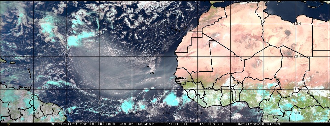
Impressive SAL surge now progressing across the MDR towards the Lesser Antilles:
1 likes
-
Shell Mound
- Category 5

- Posts: 2432
- Age: 33
- Joined: Thu Sep 07, 2017 3:39 pm
- Location: St. Petersburg, FL → Scandinavia
Re: 2020 Indicators: SST's / SAL / MSLP / Steering / Shear / Instability / Sat Images
gatorcane wrote:WeatherEmperor wrote:gatorcane wrote:So no doubt it looks to be shaping up to be an above normal season. But keep in mind we could end up with something like 2010 where we had slot of Cape Verde storms that recurved due to a weak/displaced Bermuda High and weakness over the Central Atlantic.
So far the Bermuda High has been displaced either south or way to the NE in the Atlantic allowing southerly and southwesterly flow across Florida. Even the big SAL surge will likely stay south over the Caribbean. This pattern is quite a bit different than 2015-2018 where SAL impacted Florida in June due to deep-layer easterly windflow.
One has to think that Florida and SE US might need to look to the south this year as this could be a year the Caribbean cranks out some significant hurricanes.
Gator, I want to tell you something. In April 2017, I started getting this weird feeling in my stomach. I felt this need to watch Hurricane Andrew videos on Youtube from TWC. I watched John Hope discuss Andrew in legendary fashion. I just couldnt stop watching the videos over and over because I had this weird feeling that months later a Category 5 hurricane would be staring down South Florida and as we all know, Irma threatened South Florida as a Cat 5 and that brought flashbacks to me having this funny feeling 5 months before Irma hit. Luckily, SE Florida dodged a major bullet but my gut was right...something was gonna come for South Florida.
Fast forward to 2020, and I developed another one of those gut feelings. This time, I am constantly drawn to Hurricane Wilma and Hurricane Irene (1999) videos on Youtube. I cant stop watching them. I have this deep feeling in my gut that Florida will get hit this year from a big hurricane coming from the SW Caribbean.
Maybe I am just being silly, but my gut feeling was right in 2017 and I fear it may be right again in 2020. The pattern and atmosphere just seem to be screaming for a FL hit from the Caribbean this year
Sent from my iPhone using Tapatalk
Interesting WeatherEmperor. If we do manage to get hit this year I really think it would be from a Caribbean system recurving through Florida maybe in October or late September. For some reason I don’t have that feeling we will get hit this year. I did not have a good feeling about 2017 though. I see a busy season but no direct hits for South Florida from any hurricanes. I see a lot of recurving hurricanes east of the islands and the US and some west runners in the Caribbean impacting Central America, the Yucatán and the GOM.
Maybe 2007, 2013, and 2016 would make decent analogs, since those seasons featured similar tracks. Of course 2020 would likely be busier overall. Interestingly, Central America has not experienced a major hurricane since Otto (2016), while the Yucatán Peninsula has not sustained one since Dean (2007). Personally, I suspect that either of these areas—or both—could experience a very powerful hit in 2020, à la Edith (1971), Joan (1988), or Felix (2007). This region has already seen record-breaking rainfall and flooding from the combination of Tropical Storms Amanda (EPAC) and Cristobal (ATL), so a major hurricane would be the proverbial “icing on the (unpalatable) cake,” so to speak. Additionally, another powerful hurricane could well impact Bermuda while missing the U.S., à la Nicole (2016) or Humberto (2019). The good news is that a very strong +NAO could lessen the risk to Puerto Rico and the Leeward Islands somewhat, since storms would end up tracking just to the north and east (or well to the south, closer to the Windwards Islands and northernmost South America). Anyway, I think that one of these days a Cat-4+ will make a direct strike on Bermuda, given warming SSTs over time.
0 likes
CVW / MiamiensisWx / Shell Mound
The posts in this forum are NOT official forecasts and should not be used as such. They are just the opinion of the poster and may or may not be backed by sound meteorological data. They are NOT endorsed by any professional institution or STORM2K. For official information, please refer to products from the NHC and NWS.
-
gatorcane
- S2K Supporter
- Posts: 23708
- Age: 48
- Joined: Sun Mar 13, 2005 3:54 pm
- Location: Boca Raton, FL
Re: 2020 Indicators: SST's / SAL / MSLP / Steering / Shear / Instability / Sat Images
0 likes

Re: 2020 Indicators: SST's / SAL / MSLP / Steering / Shear / Instability / Sat Images
gatorcane wrote::uarrow: Even 2010 might be a good analog as far as Cape Verde storms. If conditions are so good out there, we could see some develop sooner allowing them to start recurving sooner. For US threats will need to watch the Caribbean and GOM closely this year. Could be quite active in these areas.
Agreed. Another suggestion for a possible analog year in terms of tracks might be 1944. That year featured the Great Atlantic Hurricane that impact the northeast CONUS seaboard where it's track seemed to imply a Central Atlantic weakness but then encountered particularly strong mid level heights driving the hurricane toward the mid-Atlantic states. Additional to that was also a couple of Caribbean runners and a strong October 'cane striking Cuba and eventually Florida. I'm thinking that '44 could be a "poor man's 2020". Oh and by the way Weatheremperor, ditto on your gut feeling.
0 likes
Andy D
(For official information, please refer to the NHC and NWS products.)
(For official information, please refer to the NHC and NWS products.)
-
toad strangler

- S2K Supporter
- Posts: 4546
- Joined: Sun Jul 28, 2013 3:09 pm
- Location: Earth
- Contact:
Re: 2020 Indicators: SST's / SAL / MSLP / Steering / Shear / Instability / Sat Images
gatorcane wrote:WeatherEmperor wrote:gatorcane wrote:Interesting WeatherEmperor. If we do manage to get hit this year I really think it would be from a Caribbean system recurving through Florida maybe in October or late September. For some reason I don’t have that feeling we will get hit this year. I did not have a good feeling about 2017 though. I see a busy season but no direct hits for South Florida from any hurricanes. I see a lot of recurving hurricanes east of the islands and the US and some west runners in the Caribbean impacting Central America, the Yucatán and the GOM.
Well, like I've stated multiple times in the past month, it's a safe bet to make on open Atlantic re-curves because that is standard basin climatology. So yeah, I'd tend to agree that is more likely of an outcome for the all important Cabo or Cape Verde portion of the season. I for one though, don't feel comfortable in speculating on whether or not areas will or won't see a big storm because the atmosphere is way to fluid and complex to make a determination like that.. Even the most stout and straight forward steering set ups you can get a wrinkle which sends a storm to an unexpected place and then it's a historic season for somebody. So while I hope you are 101% correct gator, I see a table that is set with almost every plate, bowl, silverware, and fine china possible that tells me to prepare and prepare early. Which, by the way, I've already done. I have my garage loaded with treated gas, water, and canned goods, etc. If the bell rings I'll be hanging out watching the madness.
I hope all of our Gulf and SA friends have already prepared as well as yes, indications sure do make the far western part of basin look especially vulnerable this year from Caribbean origination. I mean it's great practice to prepare every season once June rolls around to begin with but this year it's probably a good idea to do it in double time.
Last edited by toad strangler on Sat Jun 20, 2020 12:27 pm, edited 1 time in total.
2 likes
My Weather Station
https://www.wunderground.com/dashboard/pws/KFLPORTS603
https://www.wunderground.com/dashboard/pws/KFLPORTS603
-
weathaguyry

- Category 5
- Posts: 1273
- Age: 22
- Joined: Wed Jun 15, 2016 5:16 am
- Location: Long Island, NY
Re: 2020 Indicators: SST's / SAL / MSLP / Steering / Shear / Instability / Sat Images
chaser1 wrote:gatorcane wrote::uarrow: Even 2010 might be a good analog as far as Cape Verde storms. If conditions are so good out there, we could see some develop sooner allowing them to start recurving sooner. For US threats will need to watch the Caribbean and GOM closely this year. Could be quite active in these areas.
Agreed. Another suggestion for a possible analog year in terms of tracks might be 1944. That year featured the Great Atlantic Hurricane that impact the northeast CONUS seaboard where it's track seemed to imply a Central Atlantic weakness but then encountered particularly strong mid level heights driving the hurricane toward the mid-Atlantic states. Additional to that was also a couple of Caribbean runners and a strong October 'cane striking Cuba and eventually Florida. I'm thinking that '44 could be a "poor man's 2020". Oh and by the way Weatheremperor, ditto on your gut feeling.
This is another good point to make, since a little extra ridging too far north and a trough over the Ohio Valley can send storms on a track like Irene riding all the way up the coast. This needs to be watched, since Sandy only had Cat 1 winds and had my area uninhabitable for almost a month. Southern Long Island is the second most vulnerable place for surge in the country besides coastal MS, however Long Island is very densely populated all the way to the coast, with entire towns of 5000+ residents below 3ft elevation. A true Cat 3+ hurricane going directly into NYC/Western Long Island would probably be the costliest hurricane in modern history.
1 likes
My posts are only my opinions and NOT official forecasts. For official forecasts, consult the National Hurricane Center or the National Weather Service.
Irene 11', Sandy 12', Fay 20’, Isaias 20’, Elsa 21’, Henri 21’, Ida 21’
Irene 11', Sandy 12', Fay 20’, Isaias 20’, Elsa 21’, Henri 21’, Ida 21’
Re: 2020 Indicators: SST's / SAL / MSLP / Steering / Shear / Instability / Sat Images
I’m keeping my eye on that awfully persistent disturbance in the middle of the open Atlantic. GFS and Euro have been on-and-off with weak development, and it doesn’t look too bad.
0 likes
Irene '11 Sandy '12 Hermine '16 5/15/2018 Derecho Fay '20 Isaias '20 Elsa '21 Henri '21 Ida '21
I am only a meteorology enthusiast who knows a decent amount about tropical cyclones. Look to the professional mets, the NHC, or your local weather office for the best information.
I am only a meteorology enthusiast who knows a decent amount about tropical cyclones. Look to the professional mets, the NHC, or your local weather office for the best information.
-
SFLcane
- S2K Supporter
- Posts: 10281
- Age: 48
- Joined: Sat Jun 05, 2010 1:44 pm
- Location: Lake Worth Florida
Re: 2020 Indicators: SST's / SAL / MSLP / Steering / Shear / Instability / Sat Images
So we have come to agreement on cv storms recurving east of the islands this year? Folks let’s wait till mid July or early August for an idea how the Bermuda high will setup. I am concerned about impacts the season especially to the Caribbean and also Florida.
4 likes
Re: 2020 Indicators: SST's / SAL / MSLP / Steering / Shear / Instability / Sat Images
Perhaps we could briefly get a TD/weak TS in the Central Atlantic this weekend?


0 likes
Irene '11 Sandy '12 Hermine '16 5/15/2018 Derecho Fay '20 Isaias '20 Elsa '21 Henri '21 Ida '21
I am only a meteorology enthusiast who knows a decent amount about tropical cyclones. Look to the professional mets, the NHC, or your local weather office for the best information.
I am only a meteorology enthusiast who knows a decent amount about tropical cyclones. Look to the professional mets, the NHC, or your local weather office for the best information.
-
toad strangler
- S2K Supporter
- Posts: 4546
- Joined: Sun Jul 28, 2013 3:09 pm
- Location: Earth
- Contact:
Re: 2020 Indicators: SST's / SAL / MSLP / Steering / Shear / Instability / Sat Images
SFLcane wrote:So we have come to agreement on cv storms recurving east of the islands this year? Folks let’s wait till mid July or early August for an idea how the Bermuda high will setup. I am concerned about impacts the season especially to the Caribbean and also Florida.
There is no agreement from me. I'm with you. Where you and I are on the E coast of peninsula FL.... there has been no strike since a Cat 1 Katrina in 2005. Nothing. Wilma of course was a hit but came from the west. That's 15 years ago now. Look at this strike map between 1900 and 2010. Our clock is TICKING


The only decade that the East Coast of FL does not have a hit since 1950 is 2010-2019

Last edited by toad strangler on Sat Jun 20, 2020 1:13 pm, edited 4 times in total.
4 likes
My Weather Station
https://www.wunderground.com/dashboard/pws/KFLPORTS603
https://www.wunderground.com/dashboard/pws/KFLPORTS603
-
SFLcane
- S2K Supporter
- Posts: 10281
- Age: 48
- Joined: Sat Jun 05, 2010 1:44 pm
- Location: Lake Worth Florida
Re: 2020 Indicators: SST's / SAL / MSLP / Steering / Shear / Instability / Sat Images
SFL about as lucky as you can possibly get. 

7 likes
-
TheStormExpert
Re: 2020 Indicators: SST's / SAL / MSLP / Steering / Shear / Instability / Sat Images
Seriously!? It’s late-June and we already have posters hinting at the all clear for Florida. 
In my opinion, Florida is not out of the woods by any means, especially considering the way this years been shaping up and all that’s currently going on worldwide we need to prepare for this season more so than ever.
Personally I think Florida, especially the south and central peninsula are at a good risk of seeing something. Even if it’s coming from the Western or Northwestern Caribbean it could still be a dangerous storm, just take Charley (2004) and Wilma (2005) for example.
2 likes
Re: 2020 Indicators: SST's / SAL / MSLP / Steering / Shear / Instability / Sat Images
I decided to go back to those 11 seasons with July MDR/Caribbean storms and remove one high and one low outlier: 2005 and 2013. 2005 has far higher named storms and hurricanes, while 2013 has far lower ACE, hurricanes, and major hurricanes. The average of the remaining 9 seasons is very close to the 11-season average:
—15.0 named storms
—8.7 hurricanes
—3.7 major hurricanes
—165.22 ACE
I don’t think it’s too outlandish to say that if we get at least one named storm in the MDR/Caribbean this July, the whole 2020 season could exceed 150 ACE and 15 named systems. However, even if this July is dead, that won’t be an automatic point against an above-average season; 2004, 2012, and 2016 all had no systems in July but ended up as significant and destructive years. Active seasons can have dead Julys, although most of them do have a few systems in that month.
5 likes
Irene '11 Sandy '12 Hermine '16 5/15/2018 Derecho Fay '20 Isaias '20 Elsa '21 Henri '21 Ida '21
I am only a meteorology enthusiast who knows a decent amount about tropical cyclones. Look to the professional mets, the NHC, or your local weather office for the best information.
I am only a meteorology enthusiast who knows a decent amount about tropical cyclones. Look to the professional mets, the NHC, or your local weather office for the best information.
-
Dougiefresh
- Tropical Depression

- Posts: 55
- Age: 36
- Joined: Thu Jun 08, 2017 8:07 am
- Location: Barbados
Re: 2020 Indicators: SST's / SAL / MSLP / Steering / Shear / Instability / Sat Images
gatorcane wrote:Impressive SAL surge now progressing across the MDR towards the Lesser Antilles:
https://i.postimg.cc/KYg8Bq2m/truecol-8.jpg
We're about to get smothered here in Barbados after TW11 gave us about 2 inches of very welcomed rain last night.
0 likes
Who is online
Users browsing this forum: No registered users and 62 guests