2022 Global Model Runs Discussion (Out thru day 16)

This is the general tropical discussion area. Anyone can take their shot at predicting a storms path.

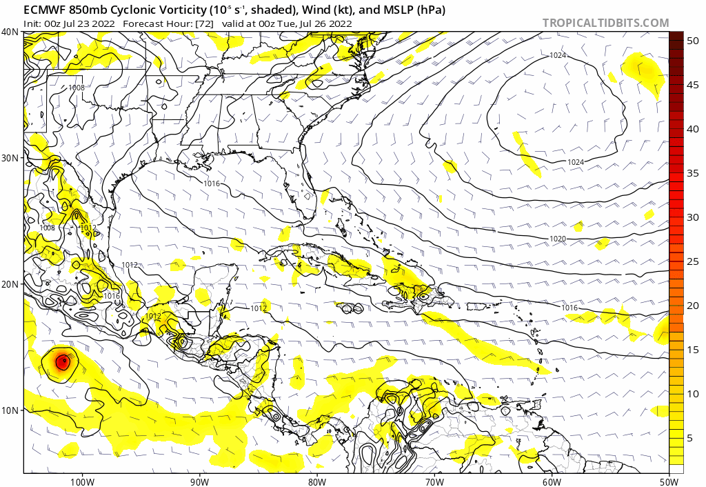
Moderator: S2k Moderators

Forum rules

The posts in this forum are NOT official forecasts and should not be used as such. They are just the opinion of the poster and may or may not be backed by sound meteorological data. They are NOT endorsed by any professional institution or STORM2K. For official information, please refer to products from the National Hurricane Center and National Weather Service.

Help Support Storm2K
Message
Author
User avatar
SFLcane
S2K Supporter
S2K Supporter
Posts: 9627
Age: 46
Joined: Sat Jun 05, 2010 1:44 pm
Location: Lake Worth Florida

Re: 2022 Global Model Runs Discussion (Out thru day 16)

#981 Postby SFLcane » Sat Jul 23, 2022 5:24 am

Image

Image
1 likes   

User avatar
MHC Tracking
Tropical Storm
Tropical Storm
Posts: 170
Joined: Mon Mar 15, 2021 10:05 am

Re: 2022 Global Model Runs Discussion (Out thru day 16)

#982 Postby MHC Tracking » Sat Jul 23, 2022 5:31 am

00z ensemble guidance suite has a battle of the models. ECENS keeps this as a "dry wave" until north of the islands, then develops it into a tropical cyclone (a significant one on some individual ensembles), while GEFS shows a weak low which quickly dissipates as it heads into cool SST's and the SAL north of Cabo Verde, ala 91L in August 2021. Late July-early August climo would suggest the second option seems more likely, but the environment north of the islands appears favorable enough for development on the ECMWF oper, if the wave survives to there. Would lean slightly towards the ECENS solution in terms of formation, but the intensity is likely overdone.
Image
Image
1 likes   

User avatar
SFLcane
S2K Supporter
S2K Supporter
Posts: 9627
Age: 46
Joined: Sat Jun 05, 2010 1:44 pm
Location: Lake Worth Florida

Re: 2022 Global Model Runs Discussion (Out thru day 16)

#983 Postby SFLcane » Sat Jul 23, 2022 7:42 am

That's a nuclear upper pattern in the SW Atlantic on the Euro! :eek:
0 likes   

User avatar
SFLcane
S2K Supporter
S2K Supporter
Posts: 9627
Age: 46
Joined: Sat Jun 05, 2010 1:44 pm
Location: Lake Worth Florida

Re: 2022 Global Model Runs Discussion (Out thru day 16)

#984 Postby SFLcane » Sat Jul 23, 2022 7:48 am

In fact The 200 hPa wind is definitely similar to that I hate to say 1992. If something stays together look out.
0 likes   

User avatar
SFLcane
S2K Supporter
S2K Supporter
Posts: 9627
Age: 46
Joined: Sat Jun 05, 2010 1:44 pm
Location: Lake Worth Florida

Re: 2022 Global Model Runs Discussion (Out thru day 16)

#985 Postby SFLcane » Sat Jul 23, 2022 10:35 am

Euro has about 90% probability of a TD near Africa and about 20-25 percent for TS near the islands which sure is interesting this far out. We will see if other models come onboard.
0 likes   

User avatar
aspen
Category 5
Category 5
Posts: 8061
Joined: Sat Oct 12, 2019 7:10 pm
Location: Connecticut, USA

Re: 2022 Global Model Runs Discussion (Out thru day 16)

#986 Postby aspen » Sat Jul 23, 2022 10:52 am

SFLcane wrote:Euro has about 90% probability of a TD near Africa and about 20-25 percent for TS near the islands which sure is interesting this far out. We will see if other models come onboard.

I think the Euro was the first to develop Bonnie, but for the first time ever, was too far north and underestimated the strength of the ridge. Maybe this ends up as a similar scenario and the wave ends up further south in reality, either running over all the Greater Antilles like Laura, Fred, and Grace, or ending up as the Caribbean runner Bonnie was thought to be.
0 likes   
Irene '11 Sandy '12 Hermine '16 5/15/2018 Derecho Fay '20 Isaias '20 Elsa '21 Henri '21 Ida '21

I am only a meteorology enthusiast who knows a decent amount about tropical cyclones. Look to the professional mets, the NHC, or your local weather office for the best information.

User avatar
captainbarbossa19
Category 5
Category 5
Posts: 1040
Joined: Wed Aug 21, 2019 11:09 pm
Location: Starkville, MS

Re: 2022 Global Model Runs Discussion (Out thru day 16)

#987 Postby captainbarbossa19 » Sat Jul 23, 2022 12:06 pm

Yikes if this verifies.

Image
1 likes   

Wampadawg
Tropical Storm
Tropical Storm
Posts: 201
Joined: Wed Oct 14, 2020 10:28 am
Location: South Texas

Re: 2022 Global Model Runs Discussion (Out thru day 16)

#988 Postby Wampadawg » Sat Jul 23, 2022 1:37 pm

Is the 12 GFS trying spin up a small TS in Texas coast the first week of August?
0 likes   
Harvey,Hanna,Beta,Texas Winter storm2021,Nicholas

User avatar
captainbarbossa19
Category 5
Category 5
Posts: 1040
Joined: Wed Aug 21, 2019 11:09 pm
Location: Starkville, MS

Re: 2022 Global Model Runs Discussion (Out thru day 16)

#989 Postby captainbarbossa19 » Sat Jul 23, 2022 1:47 pm

Wampadawg wrote:Is the 12 GFS trying spin up a small TS in Texas coast the first week of August?


Looks like it. It appears even the GFS is starting to pick up on potentially more favorable conditions.
0 likes   

User avatar
aspen
Category 5
Category 5
Posts: 8061
Joined: Sat Oct 12, 2019 7:10 pm
Location: Connecticut, USA

Re: 2022 Global Model Runs Discussion (Out thru day 16)

#990 Postby aspen » Sat Jul 23, 2022 2:01 pm

12z Euro is a tad stronger and has it recurve into Bermuda.
0 likes   
Irene '11 Sandy '12 Hermine '16 5/15/2018 Derecho Fay '20 Isaias '20 Elsa '21 Henri '21 Ida '21

I am only a meteorology enthusiast who knows a decent amount about tropical cyclones. Look to the professional mets, the NHC, or your local weather office for the best information.

User avatar
captainbarbossa19
Category 5
Category 5
Posts: 1040
Joined: Wed Aug 21, 2019 11:09 pm
Location: Starkville, MS

Re: 2022 Global Model Runs Discussion (Out thru day 16)

#991 Postby captainbarbossa19 » Sat Jul 23, 2022 2:10 pm

aspen wrote:12z Euro is a tad stronger and has it recurve into Bermuda.


Reminds me a little of Gert (2017), but further east. A lot of time to watch this though and a lot can change.
0 likes   

tolakram
Admin
Admin
Posts: 19182
Age: 60
Joined: Sun Aug 27, 2006 8:23 pm
Location: Florence, KY (name is Mark)

Re: 2022 Global Model Runs Discussion (Out thru day 16)

#992 Postby tolakram » Sat Jul 23, 2022 3:18 pm

I am enjoying this banter.

Image

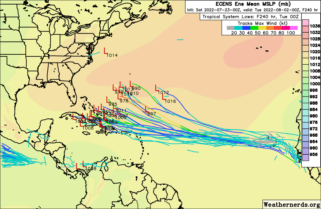
Ha, and a little more substance

 https://twitter.com/EricBlake12/status/1550917737509228545


1 likes   
M a r k
- - - - -
Join us in chat: Storm2K Chatroom Invite. Android and IOS apps also available.

The posts in this forum are NOT official forecasts and should not be used as such. Posts are NOT endorsed by any professional institution or STORM2K.org. For official information and forecasts, please refer to NHC and NWS products.

User avatar
gatorcane
S2K Supporter
S2K Supporter
Posts: 23499
Age: 46
Joined: Sun Mar 13, 2005 3:54 pm
Location: Boca Raton, FL

Re: 2022 Global Model Runs Discussion (Out thru day 16)

#993 Postby gatorcane » Sat Jul 23, 2022 3:27 pm


Interesting that the FSSE (Florida State Super Ensemble) and TVCA (model consensus - AVNI, EGRI, HWFI, EMHI, CTCI, EMNI) has a better forecasting skill than the NHC (OFCI) by day 5. In other words computers did better than humans in 2021. Makes you wonder if the NHC forecast should lean more on those two for 2022 forecasts. Also it sure would be nice to have access to the FSSE. Looks like a great model.
3 likes   

User avatar
Nimbus
Category 5
Category 5
Posts: 4933
Joined: Mon Jul 19, 2004 10:54 am

Re: 2022 Global Model Runs Discussion (Out thru day 16)

#994 Postby Nimbus » Sat Jul 23, 2022 5:41 pm

gatorcane wrote:


Interesting that the FSSE (Florida State Super Ensemble) and TVCA (model consensus - AVNI, EGRI, HWFI, EMHI, CTCI, EMNI) has a better forecasting skill than the NHC (OFCI) by day 5. In other words computers did better than humans in 2021. Makes you wonder if the NHC forecast should lean more on those two for 2022 forecasts. Also it sure would be nice to have access to the FSSE. Looks like a great model.


The discrepancy is more noticeable in the 36 hour window which is when the official warnings have to be made.
So it might not be a forecasting skill issue as much as it is erring to the side of safe public awareness and evacuation issues..
2 likes   

floridasun
Tropical Storm
Tropical Storm
Posts: 114
Joined: Tue Sep 14, 2021 3:59 pm

Re: 2022 Global Model Runs Discussion (Out thru day 16)

#995 Postby floridasun » Sat Jul 23, 2022 7:44 pm

is gfs good models without ghost storms
0 likes   

User avatar
InfernoFlameCat
Category 5
Category 5
Posts: 1966
Age: 21
Joined: Mon Dec 14, 2020 10:52 am
Location: Buford, GA

Re: 2022 Global Model Runs Discussion (Out thru day 16)

#996 Postby InfernoFlameCat » Sat Jul 23, 2022 7:46 pm

floridasun wrote:is gfs good models without ghost storms

Yeah, it is a pretty good model. It rarely misses storm genesis.
0 likes   
I am by no means a professional. DO NOT look at my forecasts for official information or make decisions based on what I post.

Goal: to become a registered expert over tropical and subtropical cyclones.

User avatar
Category5Kaiju
Category 5
Category 5
Posts: 3438
Age: 22
Joined: Thu Dec 24, 2020 12:45 pm
Location: Seattle

Re: 2022 Global Model Runs Discussion (Out thru day 16)

#997 Postby Category5Kaiju » Sun Jul 24, 2022 12:18 am

Latest GFS barely develops the EPAC orange but develops a potent EPAC hurricane in early August long-range, but it also interestingly shows a rather weak but noticeable disturbance early next month in the GoM before hitting Texas; the disturbance seems to originate from that Euro's dry wave.
0 likes   
Unless explicitly stated, all information covered in my posts is based on my opinions and observations. Please refer to a professional meteorologist or an accredited weather research agency otherwise, especially if serious decisions must be made in the event of a potentially life-threatening tropical storm or hurricane.

User avatar
cycloneye
Admin
Admin
Posts: 139593
Age: 67
Joined: Thu Oct 10, 2002 10:54 am
Location: San Juan, Puerto Rico

Re: 2022 Global Model Runs Discussion (Out thru day 16)

#998 Postby cycloneye » Sun Jul 24, 2022 5:34 am

00z Euro doesn't have anything.
0 likes   
Visit the Caribbean-Central America Weather Thread where you can find at first post web cams,radars
and observations from Caribbean basin members Click Here

User avatar
cycloneye
Admin
Admin
Posts: 139593
Age: 67
Joined: Thu Oct 10, 2002 10:54 am
Location: San Juan, Puerto Rico

Re: 2022 Global Model Runs Discussion (Out thru day 16)

#999 Postby cycloneye » Sun Jul 24, 2022 6:10 am

06Z GFS wakes up and is bigtime. This is from tropical wave that will emerge Africa later today.

Image
1 likes   
Visit the Caribbean-Central America Weather Thread where you can find at first post web cams,radars
and observations from Caribbean basin members Click Here

User avatar
cycloneye
Admin
Admin
Posts: 139593
Age: 67
Joined: Thu Oct 10, 2002 10:54 am
Location: San Juan, Puerto Rico

Re: 2022 Global Model Runs Discussion (Out thru day 16)

#1000 Postby cycloneye » Sun Jul 24, 2022 6:37 am

Before the wave develops in GOM, it brings some rainy and squally weather to the Leeward Islands, Virgin Islands, Puerto Rico and Dominican Republic.

Image
0 likes   
Visit the Caribbean-Central America Weather Thread where you can find at first post web cams,radars
and observations from Caribbean basin members Click Here


Return to “Talkin' Tropics”

Who is online

Users browsing this forum: Christiana, Cpv17, Google Adsense [Bot], Landy, TexasF6 and 61 guests