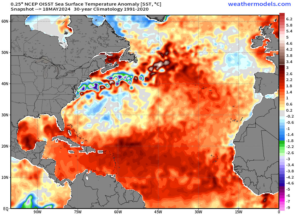
chaser1 wrote:2020 was probably the "best case" lucky scenario for a first year Nina, and I think Florida & Louisiana were particularly lucky given the unusual upper level shear that seemed to remain persistent in the western part of the basin. Unlike that year though, the 2024 forecasted NAO is anticipated to be positive during the peak of the season and with stronger high pressure over the Central Atlantic, far more storm tracks should continue further west. Just for now though, lets assume that the NAO only remains neutral. Furthermore, it is my suspicion that La Nina will not be as a significant driver with ENSO taking longer to transition. I still think that the outcome might be two groups of storm tracks and it would be those tropical cyclones developing west of 60W that I think will result in the greatest risk to the GOM, S.E. CONUS, Bahamas, and Caribbean region. One thing I'll be especially interested to see is how long will E. Atlantic surface pressures remain high ultimately pinning/suppressing the ITCZ far to the south as it is now. In my eyes, that would be a bad thing leaving a greater number of tropical genesis to occur further west. If the summer "wave train" does really get rolling by August, these SST's and even a cool neutral ENSO should be enough to have us see numerous majors to occur. I've gotta say though, if I ever thought there was a year that Florida, the Bahamas, Cuba, Yucatan and Central America were under the gun.... this is that year. By the way, Gilbert and Joan were already retired off that 1988 list.... any takers on how many more will be retired from that same list this year? I'd guess at least four.
(EDIT - "not" 2020....... meant 2012. Good on Beef Stew for catching that

)
Much like how 2005, 2013, and 2020 were alarming anomalies, I could say the same for 2010 in how it was a super active year that had very few impacts in the grand scheme of things, especially the US. We didn't even have an Ida or Idalia-like storm that formed in the W. Atlantic and hit the CONUS. For active years, while it's true that not every storm will hit land and that you can expect a reasonable number of them to fly on out to sea, 2010 went against all statistical odds, with most of its storms (especially the strong ones) going on out to sea. You probably wouldn't expect that kind of behavior from a hyperactive season.
Additionally, 2010 apparently had this sneaky, persistent issue of dry air (it mentions this on its wikipedia page), hence why it wasn't even more active given its set up and why its early season pre-late August was sort of quiet.
I would be very happy (but also extremely surprised to say the least) if 2024 ends up like 2010. Especially given how the wet anomalies overwhelmingly point towards land, I think this season will bring some memorable impacts somewhere. My guess is at least 3-4 retired names too.
Unless explicitly stated, all information in my posts is based on my own opinions and observations. Tropical storms and hurricanes can be extremely dangerous. Refer to an accredited weather research agency or meteorologist if you need to make serious decisions regarding an approaching storm.


 You are CORRECT sir! If 2020 were "best case" for Louisiana, then the only worse might be an asteroid. Good catch; definitely meant 2010!