
Check out the activity...Maybe a harbinger of a busy season??
http://www.meteo.psu.edu/rtwx/ewall/SAT ... im8ir.html
Central Atlantic / Eastern Atlantic
Moderator: S2k Moderators
Forum rules

The posts in this forum are NOT official forecasts and should not be used as such. They are just the opinion of the poster and may or may not be backed by sound meteorological data. They are NOT endorsed by any professional institution or STORM2K. For official information, please refer to products from the National Hurricane Center and National Weather Service.

Re: Central Atlantic/Coast of Africa..
They both called my attention last night before going to bed, this morning they are both still there.
The one near 9N/35W even appears to have a nice mid level circulation though in a mod shear environment, but impressive for this time of the year.
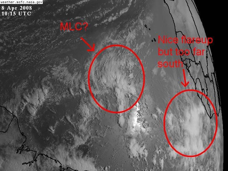
Just wanted to add, that it has survived this long for this time of the year besides only 10 knot shear but because of probably low SAL in the eastern Atlantic, thanks to prescence of strong mid latitude low pressure area near the Azores for the last few days which have weakened the winds which would usually carry the SAL westward across the eastern & central Atlantic.

The one near 9N/35W even appears to have a nice mid level circulation though in a mod shear environment, but impressive for this time of the year.
Just wanted to add, that it has survived this long for this time of the year besides only 10 knot shear but because of probably low SAL in the eastern Atlantic, thanks to prescence of strong mid latitude low pressure area near the Azores for the last few days which have weakened the winds which would usually carry the SAL westward across the eastern & central Atlantic.
Last edited by NDG on Tue Apr 08, 2008 7:10 am, edited 1 time in total.
0 likes


-
MiamiensisWx
Re: Central Atlantic/Coast of Africa..
They are definitely tropical (easterly) African waves. The convection is associated with each wave axis.
0 likes


-
cycloneye

- Admin

- Posts: 149503
- Age: 69
- Joined: Thu Oct 10, 2002 10:54 am
- Location: San Juan, Puerto Rico
Re: Central Atlantic/Coast of Africa..
From the 8:05 PM EDT TPC discussion
FINALLY...A NARROW MID- TO UPPER-LEVEL RIDGE LIES S OF 12N OVER
THE TROPICAL ATLANTIC WITH A RIDGE AXIS GENERALLY ALONG 8N.
DEEP EASTERLIES ARE PRESENT S OF THE AXIS...WITH REAL-TIME NCEP
RE-ANALYSIS DATA INDICATING EASTERLY WIND ANOMALIES OF UP TO 20
KT. OTHERWISE...SPORADIC BUT ENHANCED CONVECTION CONTINUES FROM
THE GULF OF GUINEA TO EITHER SIDE OF THE EQUATOR AS FAR W AS
30W. SATELLITE IMAGERY REVEALS A WELL-DEFINED MID-LEVEL CYCLONIC
CIRCULATION EMBEDDED WITHIN THE DYING CONVECTION CENTERED CLOSE
TO 5N21W...WITH ANOTHER ONE CLOSE TO 9N35W. THOUGH ENHANCED...
THE CONVECTION IS SUBSTANTIALLY LESS THAN WHAT WAS OCCURRING
LATE LAST WEEK INTO THIS PAST WEEKEND...WHEN AN ATMOSPHERIC
DISTURBANCE KNOWN AS KELVIN WAVE WAS MOVING THROUGH THE REGION.
$$
KIMBERLAIN
http://www.storm2k.org/weather/hw3.php? ... hwvmetric=
Here is what they are saying about this.
0 likes
-
Squarethecircle
- Category 5

- Posts: 2165
- Joined: Fri Oct 19, 2007 4:00 pm
- Location: Fairfax, VA


Re: Central Atlantic/Coast of Africa..
Wow  If this is a sign of things to come,2008 will get off to an early CV season-like July o August
0 likes
-
MiamiensisWx
Re: Central Atlantic/Coast of Africa..
canegrl04 wrote:Wow
Although I personally believe we may see an active Cape Verde season, please calm down. Most CV activity occurs in late August through mid-October. Only 2005 featured abundant MDR July development.
0 likes
-
Gustywind

- Category 5
- Posts: 12334
- Joined: Mon Sep 03, 2007 7:29 am
- Location: Baie-Mahault, GUADELOUPE
Re: Central Atlantic/Coast of Africa..
Time will tell , way too early to say that this is a or indics for a busy season or not ...in my humble opinion, whereas i appreciate to see this on the sat pic  .
.
0 likes
-
cycloneye
- Admin
- Posts: 149503
- Age: 69
- Joined: Thu Oct 10, 2002 10:54 am
- Location: San Juan, Puerto Rico
Re: Central Atlantic/Coast of Africa..
Below is the 8:05 PM EDT Discussion from TPC about the possible first wave.
AN ELONGATED MID- TO UPPER-LEVEL RIDGE EXTENDS FROM
W AFRICA TO JUST E OF THE LESSER ANTILLES...WITH AN AXIS RUNNING
FROM 20N06W TO 12N53W. ALTHOUGH CONVECTION HAS DECREASED OVER
THE TROPICAL ATLANTIC THE LAST FEW DAYS...THERE ARE TWO AREAS OF
INTEREST WHICH HAVE EMERGED OVER THE LAST 24 HOURS. THE FIRST
IS A CONVECTIVE CLUSTER N OF THE ITCZ...WITH WHAT APPEARS TO BE
A MID-LEVEL CYCLONIC CIRCULATION CENTERED NEAR 5N18W MOVING W AT
15 TO 20 KT. THIS FEATURE COULD BE CONSIDERED ONE OF THE
SEASONS FIRST AFRICAN EASTERLY WAVES. THE SECOND FEATURE IS
ALONG ELONGATED SURFACE TROUGH OF NORTHEASTERLIES CONVERGING
WITH EASTERLIES BETWEEN 8N AND 10N BETWEEN 45W AND 50W. EARLIER
VISIBLE SATELLITE IMAGERY REVEALED A TIGHTLY-COILED LOW- TO
PERHAPS MID-LEVEL CIRCULATION IN THE ASSOCIATED CONVECTION NEAR
9N46W....THOUGH THE CONVECTION SINCE THAT TIME HAS COLLAPSED.
$$
KIMBERLAIN
http://www.storm2k.org/weather/hw3.php? ... hwvmetric=
0 likes
-
MiamiensisWx
Re: Central Atlantic/Coast of Africa..
It's not the first wave. It's "one" of the first waves. There were two previous waves that left the coast this week.
0 likes
-
cycloneye
- Admin
- Posts: 149503
- Age: 69
- Joined: Thu Oct 10, 2002 10:54 am
- Location: San Juan, Puerto Rico
Re: Coast of Africa
Here is a good cloud mass (A Wave?) just off West Africa,but it will go poof as it moves more west.

0 likes
-
gatorcane

- S2K Supporter

- Posts: 23708
- Age: 48
- Joined: Sun Mar 13, 2005 3:54 pm
- Location: Boca Raton, FL
Re: Central Atlantic and Coast of Africa
Pretty impressive area of convection for this time of year, here is another shot of it. Lots of deep convection with it:

0 likes
-
cycloneye
- Admin
- Posts: 149503
- Age: 69
- Joined: Thu Oct 10, 2002 10:54 am
- Location: San Juan, Puerto Rico
Re: Central Atlantic and Coast of Africa
2:05 PM EDT Discussion:
THE ITCZ...
THE ITCZ AXIS IS CENTERED ALONG 2N10W 2N20W EQUATOR AT 34W THEN
1N43W INTO NE BRAZIL. CLUSTERS OF MODERATE/ISOLATED STRONG
CONVECTION COVER THE AREA FROM 3N TO 9N EAST OF 20W TO THE
AFRICAN COAST. A SFC TROUGH WAS ANALYZED IN THIS AREA ALONG
15W/16W ON THE 12Z SFC MAP. THERE SEEMS TO BE ENOUGH EVIDENCE TO
SUGGEST THAT THIS COULD BE A TROPICAL WAVE. SATELLITE IMAGERY
SHOWS A WELL DEFINED INVERTED V-PATTERN. THE HOVMOLLER DIAGRAM
ALSO INDICATES THE WWD PROPAGATION OF THIS SYSTEM DURING LAST
TWO DAYS...AND THE BAMAKO SOUNDING SHOWED THE PASSAGE OF THIS
TROUGH/WAVE BETWEEN APRIL 30 AND MAY 1ST. BASED ON THIS DATA AND
THE TIME OF THE YEAR....A TROPICAL WAVE WILL BE INTRODUCED ON THE
18Z MAP.
http://www.storm2k.org/weather/hw3.php? ... hwvmetric=
0 likes
Who is online
Users browsing this forum: AnnularCane, dexterlabio, WaveBreaking and 233 guests