Take a look at the latest Reynolds SST map from the NHC site:
http://www.nhc.noaa.gov/tafb/atl_anom.gif
Can anyone explain why the western portion of the Basin is generally below normal? I have not seen that large an area at or below normal in a long time.
Conversely, the eastern Atlantic is mostly above normal. While all this could change quite a bit between now and early August, it is odd to see this split SST look in the Atlantic right now. What do you all think the cause is?
SSTs in western Atlantic
Moderator: S2k Moderators
Forum rules

The posts in this forum are NOT official forecasts and should not be used as such. They are just the opinion of the poster and may or may not be backed by sound meteorological data. They are NOT endorsed by any professional institution or STORM2K. For official information, please refer to products from the National Hurricane Center and National Weather Service.
-
hurricanetrack

- HurricaneTrack.com

- Posts: 1781
- Joined: Tue Dec 02, 2003 10:46 pm
- Location: Wilmington, NC
- Contact:
SSTs in western Atlantic
0 likes

Looks pretty close to average acorss alot of the western part of the basin, maybe a touch below average overall in the western part...should be noted that I believe the average portion in the caribbean should be greatly expanded (the 0C isotherm) as much of the central Caribbean and central gulf looks about the same temp on that map as that little area that is above normal in the Carribean.
If that profile keeps up would expect a few decent cape verde systems given the temps of the water...I wouldn't be surprised once the la nina pattern eases off if those waters in the western portion warm back towards average again.
If that profile keeps up would expect a few decent cape verde systems given the temps of the water...I wouldn't be surprised once the la nina pattern eases off if those waters in the western portion warm back towards average again.
0 likes

-
Ed Mahmoud
-
cycloneye

- Admin

- Posts: 149785
- Age: 69
- Joined: Thu Oct 10, 2002 10:54 am
- Location: San Juan, Puerto Rico
Re: SSTs in western Atlantic
Yes Mark,a contrast from what the Western Atlantic shows look at the Eastern Atlantic.

0 likes
Yeah Ed your right, in the Caribbean a little below average will still be more then warm enough for a major hurricane esp with lower shear values...however in the eastern part of the basin 0.5-1C can make a fair differnece to the chances of a tropical storm forming or not from the waves further east.
0 likes
-
Ed Mahmoud
Re: SSTs in western Atlantic
cycloneye wrote:Yes Mark,a contrast from what the Western Atlantic shows look at the Eastern Atlantic.
That'd be a good set up if it lasts, more storms developing close to Africa, fewer developing close to the Caribbean and US, with more recurves and less landfalls.
0 likes
-
Eyewall
Re: SSTs in western Atlantic
The water temperatures may be a little warmer in the western atlantic. But african dust will be a huge factor in how many stormes will develop off the cost of africa. Especially in 2006 when the cape verde season was shut down by the african dust. 
0 likes
To be fair in the case of 2006 the cape Verde season did start to get going in September, we had Florence, gordon and Helene all form however the quickly forming el nino type pattern quickly brought this to a swift end not really the SAL, though that did finish off Debby earlier in that season.
0 likes
-
CrazyC83
- Professional-Met

- Posts: 34316
- Joined: Tue Mar 07, 2006 11:57 pm
- Location: Deep South, for the first time!
Re:
KWT wrote:To be fair in the case of 2006 the cape Verde season did start to get going in September, we had Florence, gordon and Helene all form however the quickly forming el nino type pattern quickly brought this to a swift end not really the SAL, though that did finish off Debby earlier in that season.
Cape Verde in 2006 was more active than in 2005, remarkably...the deep tropics had fairly little activity in 2005 as well (but it was insane in the Gulf, north/western Caribbean and subtropical Atlantic).
0 likes
-
gatorcane

- S2K Supporter

- Posts: 23708
- Age: 48
- Joined: Sun Mar 13, 2005 3:54 pm
- Location: Boca Raton, FL
Latest Reynold's SST analysis. If these warmer than normal anomalies in the eastern MDR continue, it would not surprise me that waves pushing off Africa will develop more quickly and have a better chance of deepening and recurving before making it across the MDR.
Unlike the last couple of years I do not expect to see the usual nice looking wave pushing off Africa, only for it to go poof as soon as it hits the ocean. I do believe this year is going to be different out there in the eastern MDR.

On another note, we are seeing the expected rapid rise in SSTs across the GOM -- nothing unusual for this time of year. This loop shows this:
http://www.ssd.noaa.gov/PS/TROP/DATA/RT ... -loop.html
Here is the still frame of SSTs across the Atlantic basin. SSTs are looking pretty warm, now we await to see when the upper-level winds will relax, which usually takes until August for much of the MDR.

Unlike the last couple of years I do not expect to see the usual nice looking wave pushing off Africa, only for it to go poof as soon as it hits the ocean. I do believe this year is going to be different out there in the eastern MDR.
On another note, we are seeing the expected rapid rise in SSTs across the GOM -- nothing unusual for this time of year. This loop shows this:
http://www.ssd.noaa.gov/PS/TROP/DATA/RT ... -loop.html
Here is the still frame of SSTs across the Atlantic basin. SSTs are looking pretty warm, now we await to see when the upper-level winds will relax, which usually takes until August for much of the MDR.
0 likes
-
jasons2k

- Storm2k Executive
- Posts: 8290
- Age: 52
- Joined: Wed Jul 06, 2005 12:32 pm
- Location: The Woodlands, TX
The WGOM, espeically the Bay of Campeche, is above normal:
http://www.osdpd.noaa.gov/PSB/EPS/SST/d ... 9.2008.gif
http://www.osdpd.noaa.gov/PSB/EPS/SST/d ... 9.2008.gif
0 likes
-
StormspinnerD2
Re: SSTs in western Atlantic
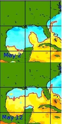
Another view of basin water temps...

Compared to one year ago...northern GoM and areas around Florida and SE coast warmer now than a year ago

Compared to one year ago...northern GoM and areas around Florida and SE coast warmer now than a year ago
0 likes
Who is online
Users browsing this forum: Ulf and 222 guests