Bermuda High Setup

This is the general tropical discussion area. Anyone can take their shot at predicting a storms path.

Moderator: S2k Moderators

Forum rules

The posts in this forum are NOT official forecasts and should not be used as such. They are just the opinion of the poster and may or may not be backed by sound meteorological data. They are NOT endorsed by any professional institution or STORM2K. For official information, please refer to products from the National Hurricane Center and National Weather Service.

Help Support Storm2K
Message
Author
User avatar
Emmett_Brown
Category 5
Category 5
Posts: 1432
Joined: Wed Aug 24, 2005 9:10 pm
Location: Sarasota FL

Bermuda High Setup

#1 Postby Emmett_Brown » Sat Jul 26, 2008 9:16 am

Well, it's the last week of July, and the busy part of the season is just around the corner. Since we are likely entering a quiet week, i would like to discuss where the Bermuda High might set up for the season. I know that the high moves around, but there is usually an "average" position that becomes established. Currently, the high looks a bit weak on the west side as shown below:

Image

Also, does anyone have a link to a map archive similar to the one below; i found this link in my bookmarks, but cant find the actual site that allows browsing of different maps. I thought it would be handy to compare this years setup to years past.

http://www.wetterzentrale.de/archive/2006/faxnws/nws1s20060809.gif
0 likes   

O Town
S2K Supporter
S2K Supporter
Posts: 5205
Age: 52
Joined: Wed Sep 07, 2005 9:37 pm
Location: Orlando, Florida 28°35'35"N 81°22'55"W

#2 Postby O Town » Sat Jul 26, 2008 10:00 am

Well the home page for the link you listed is in German?
http://www.wetterzentrale.de/

If you click on Kartenarchiv ab 1948, that seems to be the archive maps.
Direct link>>> http://www.wetterzentrale.de/topkarten/fsreaeur.html
0 likes   

User avatar
Emmett_Brown
Category 5
Category 5
Posts: 1432
Joined: Wed Aug 24, 2005 9:10 pm
Location: Sarasota FL

Re: Bermuda High Setup

#3 Postby Emmett_Brown » Sat Jul 26, 2008 10:21 am

Thanks.

I was looking at the 144 hr GFS, and it shows the high as stil pretty weak on its western side. I would assume a pattern like this would favor early recurves of a cape verde type system:

http://moe.met.fsu.edu/cgi-bin/gfstc2.cgi?time=2008072606&field=Sea+Level+Pressure&hour=144hr

You can browse various models at this page:

http://moe.met.fsu.edu/tcgengifs/
0 likes   

Frank2
Category 5
Category 5
Posts: 4061
Joined: Mon Jul 25, 2005 12:47 pm

Re: Bermuda High Setup

#4 Postby Frank2 » Sat Jul 26, 2008 11:05 am

And, once the Fall cool fronts start arriving (have they ever left?), that'll weaken the high even more, so...
0 likes   

User avatar
boca
Category 5
Category 5
Posts: 6368
Age: 60
Joined: Mon Dec 15, 2003 8:49 am
Location: Boca Raton,FL

Re: Bermuda High Setup

#5 Postby boca » Sat Jul 26, 2008 2:45 pm

I really believe this set up is simular to the 2004 season. I don't know if the pattern will change like it did in 04.its a wait and see game.
0 likes   

User avatar
Emmett_Brown
Category 5
Category 5
Posts: 1432
Joined: Wed Aug 24, 2005 9:10 pm
Location: Sarasota FL

Re: Bermuda High Setup

#6 Postby Emmett_Brown » Sat Jul 26, 2008 8:30 pm

Yes, there does seem to be a similarity to 2004, at least in my local weather here in NE FL. We have a similar rainy pattern now to what we had then. However, i have not idea if that is just cooincidence, or if the 2 synoptic patterns are actually similar. That is one of the reasons i am still looking for a good weather map archive so that i can do some comparisons. The archives i am finding only cover the conus, not the Atl.
0 likes   

User avatar
boca
Category 5
Category 5
Posts: 6368
Age: 60
Joined: Mon Dec 15, 2003 8:49 am
Location: Boca Raton,FL

Re: Bermuda High Setup

#7 Postby boca » Sat Jul 26, 2008 9:55 pm

We really haven't had the Bermuda high build in this year across Florida for more than three days at a time. These troughs are moving in or developing across the East coast every week it seems like. As long as we have this pattern in place we won't have to worry about systems coming in from the east or SE.I'm sure this will change but the pattern seems to be very progressive at the moment.
0 likes   

User avatar
Dynamic
Tropical Depression
Tropical Depression
Posts: 81
Joined: Wed Jul 19, 2006 2:11 pm

#8 Postby Dynamic » Sun Jul 27, 2008 11:43 am

If you want to setup the Bermuda High position and move a hurricane between the high and the lows near the US coast, please visit this emulator "Aim a hurricane".

It's a good tool to know how the hurricane's track are modified by the high and low areas of pressure in the Atlantic and US respectively.

Play with this and move a hurricane to the Gulfof Mexico, the Caribbean islands or the the US east coast. 8-)

http://www.nhc.noaa.gov/HAW2/english/kids/movncane.swf
0 likes   

Frank2
Category 5
Category 5
Posts: 4061
Joined: Mon Jul 25, 2005 12:47 pm

Re: Bermuda High Setup

#9 Postby Frank2 » Sun Jul 27, 2008 12:21 pm

Considering the unusually strong cold fronts moving off the EC in the past weeks (including the present cold front), it seems that should continue to keep the subtropical ridge east of it's normal position, so, that would continue to favor a Bertha-type track...

We'll see...
0 likes   

User avatar
Emmett_Brown
Category 5
Category 5
Posts: 1432
Joined: Wed Aug 24, 2005 9:10 pm
Location: Sarasota FL

Re: Bermuda High Setup

#10 Postby Emmett_Brown » Sun Jul 27, 2008 12:40 pm

The 12 Z GFS suggests a continued progression of short wave troughs in the east. At the end of this animation (168 hrs), the high looks a bit wider east to west, albeit at a more southern latitude than normal... perhaps if this verifies, it is a sign of a more stable Western flank of the high beginning to take shape?

http://moe.met.fsu.edu/cgi-bin/gfstc2.cgi?time=2008072712&field=Sea+Level+Pressure&hour=Animation
0 likes   

Frank2
Category 5
Category 5
Posts: 4061
Joined: Mon Jul 25, 2005 12:47 pm

Re: Bermuda High Setup

#11 Postby Frank2 » Sun Jul 27, 2008 1:36 pm

Perhaps Derek can shead some light on this, but, it's possible that these short-wave troughs (and attending cold fronts) are part of a long-wave pattern, and, if that's true, then, that could mean an early Fall and Winter...
0 likes   

User avatar
Emmett_Brown
Category 5
Category 5
Posts: 1432
Joined: Wed Aug 24, 2005 9:10 pm
Location: Sarasota FL

Re: Bermuda High Setup

#12 Postby Emmett_Brown » Sun Jul 27, 2008 3:02 pm

Dynamic wrote:If you want to setup the Bermuda High position and move a hurricane between the high and the lows near the US coast, please visit this emulator "Aim a hurricane".

It's a good tool to know how the hurricane's track are modified by the high and low areas of pressure in the Atlantic and US respectively.

Play with this and move a hurricane to the Gulfof Mexico, the Caribbean islands or the the US east coast. 8-)

http://www.nhc.noaa.gov/HAW2/english/kids/movncane.swf


That was a pretty fun site. Thanks for the link.
0 likes   

User avatar
Emmett_Brown
Category 5
Category 5
Posts: 1432
Joined: Wed Aug 24, 2005 9:10 pm
Location: Sarasota FL

Re: Bermuda High Setup

#13 Postby Emmett_Brown » Sun Jul 27, 2008 3:10 pm

Frank2 wrote:Perhaps Derek can shead some light on this, but, it's possible that these short-wave troughs (and attending cold fronts) are part of a long-wave pattern, and, if that's true, then, that could mean an early Fall and Winter...


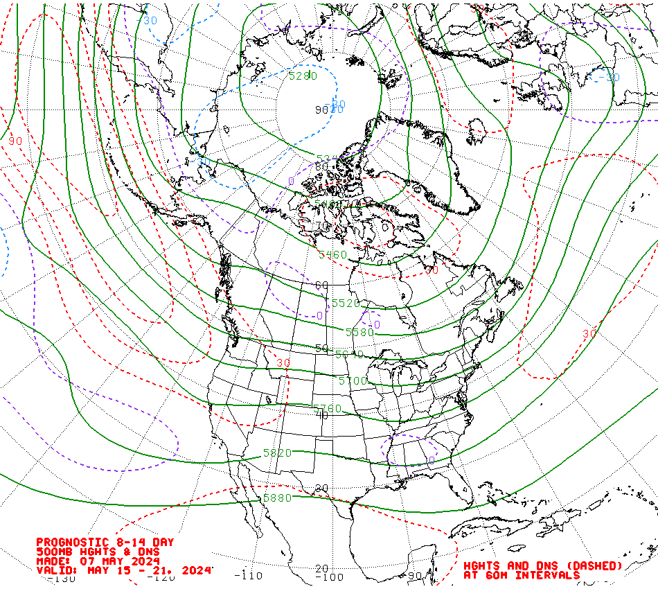
Good point. The interesting thing about this time of year, is that the current pattern might persist, as you suggest, and usher in early fall, or we could see a complete 180 with the trough being replaced by a ridge.

The 8-14 day outlook for 500 mb from the climate prediction center suggests that the current pattern will continue, but the trough in the east looks pretty shallow:

Image
0 likes   

User avatar
gatorcane
S2K Supporter
S2K Supporter
Posts: 23692
Age: 47
Joined: Sun Mar 13, 2005 3:54 pm
Location: Boca Raton, FL

#14 Postby gatorcane » Sun Jul 27, 2008 3:19 pm

Emmett et al while trying to determine the Bermuda high and long-wave pattern setup months in advance makes for an interesting discussion of speculation, there is not a high enough level of long-range forecasting skill to know the influence and position of the Bermuda high for the peak of the Atlantic Hurricane season (Sept. 10) let alone for more than a week in advance.

It's important to note, as many members have in this thread, that current long-wave patterns that exist currently or in the previous weeks/months have no bearing on the potential long-wave patterns in future weeks/months.
0 likes   

User avatar
Emmett_Brown
Category 5
Category 5
Posts: 1432
Joined: Wed Aug 24, 2005 9:10 pm
Location: Sarasota FL

Re:

#15 Postby Emmett_Brown » Sun Jul 27, 2008 4:11 pm

gatorcane wrote:Emmett et al while trying to determine the Bermuda high and long-wave pattern setup months in advance makes for an interesting discussion of speculation, there is not a high enough level of long-range forecasting skill to know the influence and position of the Bermuda high for the peak of the Atlantic Hurricane season (Sept. 10) let alone for more than a week in advance.

It's important to note, as many members have in this thread, that current long-wave patterns that exist currently or in the previous weeks/months have no bearing on the potential long-wave patterns in future weeks/months.


Gator, i agree with you. Interesting discussion is all this is about really, and this is one of my favorite lull topics. Since there are no storms around, might as well track the Bermuda high.

The long range 12z GFS shows a more robust high building, and just happens to track a fairly sharp wave below it near the islands at 204h:

Image
0 likes   

User avatar
boca
Category 5
Category 5
Posts: 6368
Age: 60
Joined: Mon Dec 15, 2003 8:49 am
Location: Boca Raton,FL

Re: Bermuda High Setup

#16 Postby boca » Sun Jul 27, 2008 8:29 pm

If the pattern that were currently in doesn't break down.All the cape verde systems will have tracks simular to Bertha. We should hope the pattern stays put because if we have a train of storms coming off Africa they'll all recurve harmlessly out to see as long as this trough set up continues.Maybe Frank2 has a valid point with this season.
0 likes   

User avatar
gatorcane
S2K Supporter
S2K Supporter
Posts: 23692
Age: 47
Joined: Sun Mar 13, 2005 3:54 pm
Location: Boca Raton, FL

Re: Bermuda High Setup

#17 Postby gatorcane » Sun Jul 27, 2008 8:43 pm

boca wrote:If the pattern that were currently in doesn't break down.All the cape verde systems will have tracks simular to Bertha. We should hope the pattern stays put because if we have a train of storms coming off Africa they'll all recurve harmlessly out to see as long as this trough set up continues.Maybe Frank2 has a valid point with this season.


1995 is a good example of what happens when the Bermuda High is displaced more east..lots of Cape Verde systems but all of them recurved well East of the CONUS. Note the Leeward Islands had some activity though.

Image
0 likes   

User avatar
deltadog03
Professional-Met
Professional-Met
Posts: 3580
Joined: Tue Jul 05, 2005 6:16 pm
Location: Macon, GA

#18 Postby deltadog03 » Sun Jul 27, 2008 10:35 pm

I am really inclined to think that the high over the SE is going to be "overall" weaker than normal. We have seen it ALL summer. The high will build in for a day or 2 and then back to an eastern long wave trof. We are about half finished with summer....so....
0 likes   

pup55
Tropical Low
Tropical Low
Posts: 42
Joined: Wed Aug 24, 2005 12:24 pm

Re: Bermuda High Setup

#19 Postby pup55 » Mon Jul 28, 2008 7:08 am

If the pattern that were currently in doesn't break down


I certainly hope it does break down. That Bermuda high is a drought maker for the SEUS. Its current position (westerly) causes storm systems to rotate into the Ohio Valley rather than into GA/SC. The reservoir levels in this area are still at multi-decade lows because of the persistent drought conditions. Meanwhile, in the midwest, they are still soggy from all the rain this spring.

Hartwell (GA/SC border) is down 14 feet from its so-called "normal pool".

So if you guys have any influence, and can send the Bermuda High east a few hundred miles, it will suit all of us fine. Even better, if you can steer one of those tropical systems our way, it would be delightful.

The water supply for three states, including ATL is still in jeopardy and could use some replenishment.
0 likes   

Frank2
Category 5
Category 5
Posts: 4061
Joined: Mon Jul 25, 2005 12:47 pm

Re: Bermuda High Setup

#20 Postby Frank2 » Mon Jul 28, 2008 11:27 am

deltadog03 has a good (professional) point - here in South Florida, we have seen very few days this summer with well-established "strong high to the north" easterlies. Rather, we've seen many more days with winds from a southerly direction - a sure sign that the high is weak or well to the east, and, is always an encouraging sign when it comes to CV-type systems not heading this far west...

And, as said, the summer is already half over (our new Church book already goes though the beginning of November), so, the clock is quickly ticking...

Frank
0 likes   


Return to “Talkin' Tropics”

Who is online

Users browsing this forum: FLCrackerGirl, wileytheartist and 21 guests