
I was looking at the water vapor and noticed this area at 12n and 80W,about a week ago the GFS was picking up on something down in that area.
http://www.goes.noaa.gov/browsh3.html
southwest Caribbean
Moderator: S2k Moderators
Forum rules

The posts in this forum are NOT official forecasts and should not be used as such. They are just the opinion of the poster and may or may not be backed by sound meteorological data. They are NOT endorsed by any professional institution or STORM2K. For official information, please refer to products from the National Hurricane Center and National Weather Service.
southwest Caribbean
0 likes


Re: southwest Caribbean
Models are beginning to latch on to some development over the SW carribean later this week. The gfs has indicated this area could become more favorable for development for the last week..Were getting closer to the time of year where this area needs to be watched closely. Some of the other globals also begin to lower pressures..With convection beginning to fire this area stands a chance in 3-5 days. GFS at 144
http://www.nco.ncep.noaa.gov/pmb/nwprod ... n_144l.gif
http://www.nco.ncep.noaa.gov/pmb/nwprod ... n_144l.gif
0 likes
Re: southwest Caribbean
Wonder if this is a ghost system telling us what is in store for October?
0 likes
-
CourierPR

- Category 5

- Posts: 1336
- Age: 72
- Joined: Tue Aug 31, 2004 7:53 pm
- Location: Pompano Beach, Florida
Re: southwest Caribbean
I mentioned this area yesterday in the Long Range Models thread. It's getting to be that time of year when we look down there for development.
0 likes
-
terrapintransit

- Category 1

- Posts: 275
- Age: 51
- Joined: Tue Sep 04, 2007 8:08 pm
- Location: Williamsport, Pa
-
lonelymike
- S2K Supporter

- Posts: 634
- Joined: Sat Jul 26, 2008 10:12 am
- Location: walton county fla
Re: southwest Caribbean
NHC doesn't mention it and GFS is notorious for spinning up cyclones. Not saying it won't develop but given it is the Global For poop model ya gotta wonder. 
0 likes
Re: southwest Caribbean
Maybe some weak turning in the northern part but looks like it is headed west and overland.
0 likes
-
CourierPR
- Category 5
- Posts: 1336
- Age: 72
- Joined: Tue Aug 31, 2004 7:53 pm
- Location: Pompano Beach, Florida
Re: southwest Caribbean
Sanibel wrote:Maybe some weak turning in the northern part but looks like it is headed west and overland.
Sanibel, it looks to me like the convection has expanded, but I don't see it moving west.
0 likes
-
CourierPR
- Category 5
- Posts: 1336
- Age: 72
- Joined: Tue Aug 31, 2004 7:53 pm
- Location: Pompano Beach, Florida
Re: southwest Caribbean
AccuWeather says that conditions are somewhat favorable for slow development there.
0 likes


-
gatorcane

- S2K Supporter
- Posts: 23708
- Age: 48
- Joined: Sun Mar 13, 2005 3:54 pm
- Location: Boca Raton, FL
Re: southwest Caribbean
if something develops it would move NNW into the NW Caribbean due to the large trough extending SW through the GOM into the BOC.
0 likes
-
caneman
Re: southwest Caribbean
Been watching it too. It is interesting but needs to persist. CMC and GFS showing some lowering of pressures from this area up into the BOC during the next week. Bears watching.
0 likes
Re: southwest Caribbean
Strikes me as moving too fast which means there's nothing at the surface.
If this was a fast developing system it is right under us with a trough border to the west in the Gulf!
If this was a fast developing system it is right under us with a trough border to the west in the Gulf!
0 likes
-
dixiebreeze

- S2K Supporter
- Posts: 5140
- Joined: Wed Sep 03, 2003 5:07 pm
- Location: crystal river, fla.
-
gatorcane
- S2K Supporter
- Posts: 23708
- Age: 48
- Joined: Sun Mar 13, 2005 3:54 pm
- Location: Boca Raton, FL
Re: southwest Caribbean
Sanibel wrote:Strikes me as moving too fast which means there's nothing at the surface.
If this was a fast developing system it is right under us with a trough border to the west in the Gulf!
October-like setup will be in place through the weekend, then ridging builds back in across the Eastern CONUS and GOM going back to a September-like regime.
The blob should fizzle away though soon.
0 likes
-
terrapintransit
- Category 1
- Posts: 275
- Age: 51
- Joined: Tue Sep 04, 2007 8:08 pm
- Location: Williamsport, Pa
-
Tampa Bay Hurricane

- Category 5
- Posts: 5597
- Age: 38
- Joined: Fri Jul 22, 2005 7:54 pm
- Location: St. Petersburg, FL
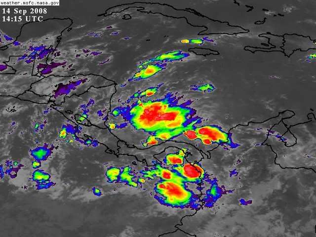
Looking very intense, and with the trough approaching from the west
over the Gulf may get pulled up towards the SE Gulf and Florida,
bringing chances for rain later this week. A cold front will stall
near north Florida, and may bring this area of heavy thunderstorms
into Florida, based on the latest infrared imagery (showing a strong
front pushing through the Gulf and expected to reach all the way into
north Florida in a few days).
Regardless of Tropical Development, I expect the moisture
from this area to bring squally weather with heavy thunderstorms
and gusty winds along a stalled front over Florida in the next
2-4 days, before the ridge builds back in. The center of the convection
has been relocating very quickly to the NNW, it is now almost in the
Northwest Caribbean. The southern part of this tropical wave is pushing
into Central America, but the northern part is clearly being influenced by the gulf
trough and being drawn northward.
0 likes
Who is online
Users browsing this forum: No registered users and 315 guests