4 years ago today, Hurricane Jeanne strikes Florida.

This is the general tropical discussion area. Anyone can take their shot at predicting a storms path.

Moderator: S2k Moderators

Forum rules

The posts in this forum are NOT official forecasts and should not be used as such. They are just the opinion of the poster and may or may not be backed by sound meteorological data. They are NOT endorsed by any professional institution or STORM2K. For official information, please refer to products from the National Hurricane Center and National Weather Service.

Help Support Storm2K
Message
Author
User avatar
Category 5
Category 5
Category 5
Posts: 10074
Age: 35
Joined: Sun Feb 11, 2007 10:00 pm
Location: New Brunswick, NJ
Contact:

4 years ago today, Hurricane Jeanne strikes Florida.

#1 Postby Category 5 » Thu Sep 25, 2008 12:18 am

ZCZC MIATCPAT1 ALL
TTAA00 KNHC DDHHMM
BULLETIN
HURRICANE JEANNE ADVISORY NUMBER 50
NWS TPC/NATIONAL HURRICANE CENTER MIAMI FL
11 PM EDT SAT SEP 25 2004

...EYE OF HURRICANE JEANNE BEGINNING TO MOVE ONSHORE OVER MARTIN AND
ST. LUCIE COUNTIES...

A HURRICANE WARNING REMAINS IN EFFECT ALONG THE FLORIDA EAST COAST
FROM FLORIDA CITY NORTHWARD TO ST. AUGUSTINE...INCLUDING LAKE
OKEECHOBEE. THE HURRICANE WARNING FOR A PORTION OF THE SOUTHEAST
FLORIDA COAST MAY BE DISCONTINUED EARLY ON SUNDAY.

AT 11 PM EDT...0300Z...THE GOVERNMENT OF THE BAHAMAS HAS DOWNGRADED
THE HURRICANE WARNING TO A TROPICAL STORM WARNING FOR GRAND
BAHAMA...THE ABACOS...BIMINI...AND THE BERRY ISLANDS...AND
DISCONTINUED THE HURRICANE WARNINGS FOR ELEUTHERA...ANDROS...AND
NEW PROVIDENCE ISLAND.

A TROPICAL STORM WARNING AND A HURRICANE WATCH REMAIN IN EFFECT
FROM NORTH OF ST. AUGUSTINE NORTHWARD TO ALTAMAHA SOUND GEORGIA.

AT 11 PM EDT...0300Z...THE TROPICAL STORM WARNING HAS BEEN EXTENDED
WESTWARD ALONG THE GULF COAST OF NORTHERN FLORIDA TO INDIAN PASS. A
TROPICAL STORM WARNING IS NOW EFFECT FOR THE GULF COAST OF FLORIDA
FROM EAST CAPE SABLE NORTHWARD TO INDIAN PASS.

A HURRICANE WATCH REMAINS IN EFFECT FROM ENGLEWOOD TO THE SUWANNEE
RIVER.

A TROPICAL STORM WATCH REMAINS IN EFFECT FROM SOUTH OF FLORIDA CITY
AROUND THE SOUTHERN END OF THE FLORIDA PENINSULA TO JUST SOUTH OF
EAST CAPE SABLE INCLUDING FLORIDA BAY...AND FOR THE FLORIDA KEYS
NORTH OF THE SEVEN MILE BRIDGE.

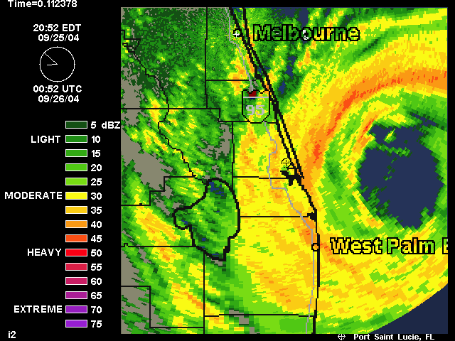
AT 11 PM EDT...0300Z...THE CENTER OF HURRICANE JEANNE WAS LOCATED
NEAR LATITUDE 27.2 NORTH... LONGITUDE 80.0 WEST OR ABOUT 15 MILES
MILES EAST OF STUART FLORIDA.

JEANNE IS MOVING SLIGHTLY NORTH OF WEST NEAR 13 MPH...AND A GRADUAL
TURN TOWARD THE NORTHWEST IS EXPECTED DURING THE NEXT 24 HOURS. ON
THIS TRACK THE CENTER WILL BE MOVING INLAND NEAR MIDNIGHT...AND
ACROSS CENTRAL FLORIDA ON SUNDAY.

MAXIMUM SUSTAINED WINDS ARE NEAR 115 MPH...WITH HIGHER GUSTS.
JEANNE IS A DANGEROUS CATEGORY THREE HURRICANE ON THE
SAFFIR-SIMPSON HURRICANE SCALE. STRONGER WINDS...ESPECIALLY IN
GUSTS...ARE LIKELY TO OCCUR ON HIGH RISE BUILDINGS. JEANNE WILL
BEGIN TO WEAKEN AFTER THE CENTER MOVES INLAND.

HURRICANE FORCE WINDS EXTEND OUTWARD UP TO 70 MILES FROM THE
CENTER...AND TROPICAL STORM FORCE WINDS EXTEND OUTWARD UP
TO 205 MILES. A FLORIDA COASTAL MONITORING PROGRAM WIND TOWER NEAR
VERO BEACH RECENTLY REPORTED SUSTAINED WINDS OF 68 MPH WITH A GUST
TO 94 MPH.

AFTER THE ISSUANCE OF THE FORECAST/ADVISORY...A NOAA HURRICANE
HUNTER AIRCRAFT REPORTED A MINIMUM CENTRAL PRESSURE OF 953
MB...28.14 INCHES.

COASTAL STORM SURGE FLOODING OF 4 TO 7 FEET ABOVE NORMAL TIDE
LEVELS...ALONG WITH LARGE AND DANGEROUS BATTERING WAVES...CAN BE
EXPECTED NEAR AND TO THE NORTH OF WHERE THE CENTER MAKES LANDFALL
ALONG THE FLORIDA EAST COAST. A STORM SURGE OF UP TO 5 FEET ABOVE
THE PRESENT WATER LEVEL IS LIKELY TO OCCUR MAINLY ON THE EAST SIDE
OF LAKE OKEECHOBEE.

TIDES OF 1 TO 3 FEET ABOVE NORMAL ARE POSSIBLE IN THE WARNED AREA
ALONG THE FLORIDA WEST COAST....POSSIBLY REACHING 3 TO 6 FEET IN
AREAS OF ONSHORE FLOW NORTH OF TAMPA BAY.

RAINFALL TOTALS OF 5 TO 10 INCHES...WITH ISOLATED HIGHER AMOUNTS
...ARE POSSIBLE NEAR THE PATH OF JEANNE OVER FLORIDA.

ISOLATED TORNADOES ARE POSSIBLE OVER PORTIONS OF THE EAST FLORIDA
PENINSULA TONIGHT.

REPEATING THE 11 PM EDT POSITION...27.2 N... 80.0 W. MOVEMENT
TOWARD...WEST NEAR 13 MPH. MAXIMUM SUSTAINED WINDS...115 MPH.
MINIMUM CENTRAL PRESSURE... 953 MB.

FOR STORM INFORMATION SPECIFIC TO YOUR AREA...PLEASE MONITOR
PRODUCTS ISSUED BY YOUR LOCAL WEATHER OFFICE.

INTERMEDIATE ADVISORIES WILL BE ISSUED BY THE NATIONAL HURRICANE
CENTER AT 1 AM EDT AND 3 AM EDT FOLLOWED BY THE NEXT COMPLETE
ADVISORY AT 5 AM EDT.

FORECASTER PASCH

$$
NNNN

Image
Image
0 likes   

User avatar
Blown Away
S2K Supporter
S2K Supporter
Posts: 10154
Joined: Wed May 26, 2004 6:17 am

Re: 4 years ago today, Hurricane Jeanne strikes Florida.

#2 Postby Blown Away » Thu Sep 25, 2008 6:23 am

Remember it well, it was the second hurricane eye for me in 2 weeks. There was some very strong winds, they were gusting well over 100 mph in Hobe Sound. I lost power for almost 2 weeks and got it back the day before Jeanne and then lost it again for another 10 days after Jeanne. September 2004 sure was memorable.
0 likes   

User avatar
DESTRUCTION5
Category 5
Category 5
Posts: 4423
Age: 43
Joined: Wed Sep 03, 2003 11:25 am
Location: Stuart, FL

Re: 4 years ago today, Hurricane Jeanne strikes Florida.

#3 Postby DESTRUCTION5 » Thu Sep 25, 2008 8:03 am

Blown_away wrote:Remember it well, it was the second hurricane eye for me in 2 weeks. There was some very strong winds, they were gusting well over 100 mph in Hobe Sound. I lost power for almost 2 weeks and got it back the day before Jeanne and then lost it again for another 10 days after Jeanne. September 2004 sure was memorable.


Ditto....27 inches of rain here in Stuart for Sept 04 and we had power for 3 days...Sept 1-3....How fun it was...NOT!
0 likes   

O Town
S2K Supporter
S2K Supporter
Posts: 5205
Age: 52
Joined: Wed Sep 07, 2005 9:37 pm
Location: Orlando, Florida 28°35'35"N 81°22'55"W

#4 Postby O Town » Thu Sep 25, 2008 9:59 am

3rd storm in 2004 to knock out my power, this time it was only for a 3 days.
We almost made it through and then right when I pulled the eggs off the stove for breakfast a large oak fell on my front gate taking down the power lines and had the pole leaning pretty hard. We were trapped in our yard by trees and power lines, had to hop the fence if we needed to leave the house. LOL.
0 likes   

User avatar
Cyclenall
Category 5
Category 5
Posts: 6666
Joined: Thu Jun 08, 2006 10:01 pm
Location: Ontario, Canada

#5 Postby Cyclenall » Thu Sep 25, 2008 2:28 pm

The organization of Hurricane Jeanne was very impressive and I haven't seen many keep that up to landfall. I don't know why there isn't as much discussion on Jeanne as there is on Ivan and Frances. It should have caused notable wind damage from the looks of the relatively solid eyewall.
0 likes   

User avatar
Blown Away
S2K Supporter
S2K Supporter
Posts: 10154
Joined: Wed May 26, 2004 6:17 am

Re:

#6 Postby Blown Away » Thu Sep 25, 2008 2:52 pm

Cyclenall wrote:The organization of Hurricane Jeanne was very impressive and I haven't seen many keep that up to landfall. I don't know why there isn't as much discussion on Jeanne as there is on Ivan and Frances. It should have caused notable wind damage from the looks of the relatively solid eyewall.


Speaking from direct experience, Frances had caused so much damage it was hard to tell Frances damage from Jeanne's. Jeanne had much stronger winds than Frances in Hobe Sound. GOM get's more damage because they build homes on land that is 2 inches above sea level.
0 likes   

User avatar
VeniceInlet
Tropical Depression
Tropical Depression
Posts: 92
Joined: Sun Jun 11, 2006 10:12 pm
Location: Nokomis, FL

Re: Re:

#7 Postby VeniceInlet » Thu Sep 25, 2008 3:09 pm

Blown_away wrote: GOM get's more damage because they build homes on land that is 2 inches above sea level.


If I'm not wrong, I believe GOMs get more damage because the shelf up to the coast is shallow and gradual, which allows for bigger surges to come up on shore.

With east coast FL any surge gets dispersed more easily than in the GOM because the continental shelf drops off dramatically right off the coast. Except for, I believe, Biscayne Bay which is still subject to bigger surges.
0 likes   

User avatar
DanKellFla
Category 5
Category 5
Posts: 1291
Joined: Fri Mar 17, 2006 12:02 pm
Location: Lake Worth, Florida

#8 Postby DanKellFla » Fri Sep 26, 2008 10:45 pm

I had no power for 5 days after Frances. For Jeanne, I stayed with some friends. The next day I came home and I had power. I was so excited. Then, I called my friends and told them to come over.
0 likes   

User avatar
Tampa Bay Hurricane
Category 5
Category 5
Posts: 5597
Age: 37
Joined: Fri Jul 22, 2005 7:54 pm
Location: St. Petersburg, FL

#9 Postby Tampa Bay Hurricane » Sat Sep 27, 2008 12:01 am

Hurricane Jeanne was the worst hurricane to hit my area in recent
years- hit as a category 1; hurricane force winds ripped off roofs,
blew open doors, did structural damage; destroyed hanging protective
curtains stripping out every piece; ripped off my roof tiles; tore open
screens; Large oak trees that had withstood 80 mph winds during the 1998 El
Nino Derecho fell. Winds on Saint Petersburg Beach were
sustained at 91 mph with gusts to 104 mph: bcbaywatch.com
you'll have to go through the history files.
0 likes   


Return to “Talkin' Tropics”

Who is online

Users browsing this forum: Blown Away, Cpv17, duilaslol, fig, HeatherAKC, skillz305, Stratton23, TallyTracker, Ulf, WaveBreaking and 78 guests