Area of disturbed wx in the EGOM

This is the general tropical discussion area. Anyone can take their shot at predicting a storms path.

Moderator: S2k Moderators

Forum rules

The posts in this forum are NOT official forecasts and should not be used as such. They are just the opinion of the poster and may or may not be backed by sound meteorological data. They are NOT endorsed by any professional institution or STORM2K. For official information, please refer to products from the National Hurricane Center and National Weather Service.

Help Support Storm2K
Message
Author
User avatar
AJC3
Admin
Admin
Posts: 4002
Age: 61
Joined: Tue Aug 31, 2004 7:04 pm
Location: Ballston Spa, New York
Contact:

Area of disturbed wx in the EGOM

#1 Postby AJC3 » Sat Sep 27, 2008 6:30 am

I know the GOMEX home brew thread started mentioning this, but I think it deserves a separate thread.

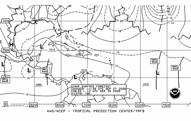
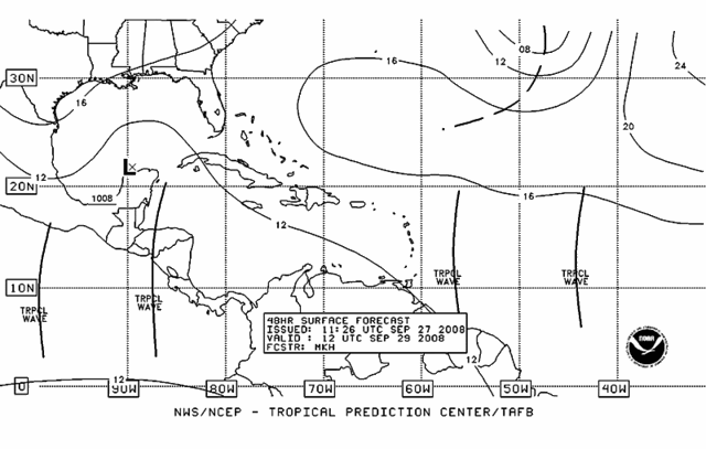
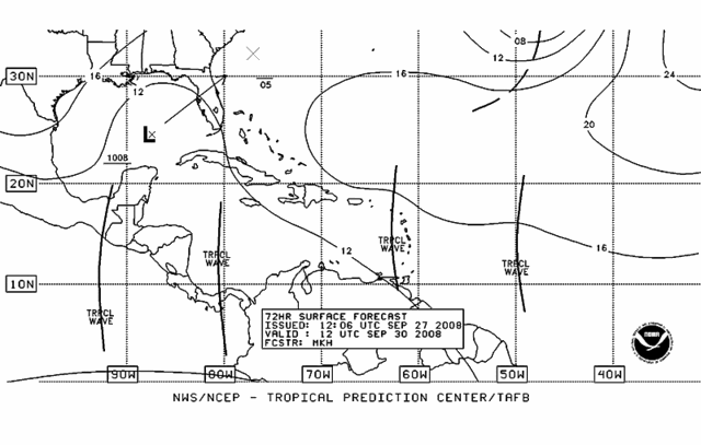
Most of the model guidance has latched onto this area, eventually lifting some sort of low north and then northeast out of that area during the early to middle part of next week. From the looks of the current and forecast synoptic mid-upper level pattern down there, conditions might favor, if anything, more of a sloppy "right-sided" BE (baroclinically enhanced) type of system.


Image
0 likes   

User avatar
ronjon
Category 5
Category 5
Posts: 4825
Joined: Fri Aug 19, 2005 5:17 pm
Location: Hernando Beach, FL

Re: Area of disturbed wx east of the Yucatan

#2 Postby ronjon » Sat Sep 27, 2008 7:14 am

Agreed AJC3 - upper level shear looks pretty high over the central and northern GOM. There may be a small window for development if the low pressure develops in the western caribbean where shear is lighter and forecast to lessen over the next three days. In any case, I think low pressure will develop since it'll be juiced baroclinically from the trough sharpening over the east coast in 3 days. Perhaps a hybrid (subtropical like) storm with heavy rain and wind on the east side?
0 likes   

User avatar
HURAKAN
Professional-Met
Professional-Met
Posts: 46086
Age: 38
Joined: Thu May 20, 2004 4:34 pm
Location: Key West, FL
Contact:

#3 Postby HURAKAN » Sat Sep 27, 2008 7:57 am

Image

Image

Image
0 likes   

jlauderdal
S2K Supporter
S2K Supporter
Posts: 7185
Joined: Wed May 19, 2004 5:46 am
Location: NE Fort Lauderdale
Contact:

Re: Area of disturbed wx east of the Yucatan

#4 Postby jlauderdal » Sat Sep 27, 2008 8:29 am

gfs showed this yesterday and continues with the idea, gatorcane where are you, you might get some wind and rain
Last edited by jlauderdal on Sat Sep 27, 2008 8:50 am, edited 2 times in total.
0 likes   

User avatar
gatorcane
S2K Supporter
S2K Supporter
Posts: 23692
Age: 47
Joined: Sun Mar 13, 2005 3:54 pm
Location: Boca Raton, FL

Re: Area of disturbed wx east of the Yucatan

#5 Postby gatorcane » Sat Sep 27, 2008 8:38 am

I'm here jlauderdale. Yeah its definitely something to watch. As we move into October, it can be busy for Florida especially Southern Florida as we move farther into October.
0 likes   

User avatar
HURAKAN
Professional-Met
Professional-Met
Posts: 46086
Age: 38
Joined: Thu May 20, 2004 4:34 pm
Location: Key West, FL
Contact:

#6 Postby HURAKAN » Sat Sep 27, 2008 8:41 am

The position and time of the year is very reminiscent of Keith, 2000. Of course, nothing like it is expected from this.
0 likes   

jlauderdal
S2K Supporter
S2K Supporter
Posts: 7185
Joined: Wed May 19, 2004 5:46 am
Location: NE Fort Lauderdale
Contact:

Re: Area of disturbed wx east of the Yucatan

#7 Postby jlauderdal » Sat Sep 27, 2008 8:53 am

gatorcane wrote:I'm here jlauderdale. Yeah its definitely something to watch. As we move into October, it can be busy for Florida especially Southern Florida as we move farther into October.


its an interesting setup today with that front finally moving north, i biked in some very heavy rain this morning
0 likes   

User avatar
Tampa Bay Hurricane
Category 5
Category 5
Posts: 5597
Age: 37
Joined: Fri Jul 22, 2005 7:54 pm
Location: St. Petersburg, FL

GOM, homebrew?

#8 Postby Tampa Bay Hurricane » Sat Sep 27, 2008 8:57 am

Image

Heavy Thunderstorms in the Northwest Caribbean now.
0 likes   

Frank2
Category 5
Category 5
Posts: 4061
Joined: Mon Jul 25, 2005 12:47 pm

#9 Postby Frank2 » Sat Sep 27, 2008 9:20 am

I just drove through a very heavy rain shower - also in Broward County...

Oh, well - it's only 10 a.m. and already it's been one of those days...

Frank
0 likes   

jlauderdal
S2K Supporter
S2K Supporter
Posts: 7185
Joined: Wed May 19, 2004 5:46 am
Location: NE Fort Lauderdale
Contact:

Re:

#10 Postby jlauderdal » Sat Sep 27, 2008 9:27 am

Frank2 wrote:I just drove through a very heavy rain shower - also in Broward County...

Oh, well - it's only 10 a.m. and already it's been one of those days...

Frank


yep its raining here again, the good stuff is staying off to our SE, my daughters soccer match is in an hour so that field is getting a good soaking :D
0 likes   

Sanibel
Category 5
Category 5
Posts: 10375
Joined: Mon Aug 30, 2004 11:06 pm
Location: Offshore SW Florida

Re: Area of disturbed wx east of the Yucatan

#11 Postby Sanibel » Sat Sep 27, 2008 10:10 am

I didn't need the models you could see the signs in the clouds two days ago.

I can't find the center but this should be straight tropical. No way to tell what this land interaction will do. It tends to wipe out south moving systems some times. However the front should aid it.
0 likes   

User avatar
gatorcane
S2K Supporter
S2K Supporter
Posts: 23692
Age: 47
Joined: Sun Mar 13, 2005 3:54 pm
Location: Boca Raton, FL

Re: Area of disturbed wx east of the Yucatan

#12 Postby gatorcane » Sat Sep 27, 2008 10:14 am

all eyes will shift on the Western Caribbean over the next couple of days.

Image
0 likes   

User avatar
boca
Category 5
Category 5
Posts: 6368
Age: 60
Joined: Mon Dec 15, 2003 8:49 am
Location: Boca Raton,FL

Re: Area of disturbed wx east of the Yucatan

#13 Postby boca » Sat Sep 27, 2008 10:18 am

I wonder if this would pull a wrong way Lenny senario?
0 likes   

Sanibel
Category 5
Category 5
Posts: 10375
Joined: Mon Aug 30, 2004 11:06 pm
Location: Offshore SW Florida

Re: Area of disturbed wx east of the Yucatan

#14 Postby Sanibel » Sat Sep 27, 2008 10:45 am

It angers me that they don't put a floater on it when they need to.
0 likes   

Frank2
Category 5
Category 5
Posts: 4061
Joined: Mon Jul 25, 2005 12:47 pm

#15 Postby Frank2 » Sat Sep 27, 2008 10:47 am

...it's not an invest yet, either - perhaps later today...

Frank
0 likes   

User avatar
Tampa Bay Hurricane
Category 5
Category 5
Posts: 5597
Age: 37
Joined: Fri Jul 22, 2005 7:54 pm
Location: St. Petersburg, FL

#16 Postby Tampa Bay Hurricane » Sat Sep 27, 2008 10:50 am

This needs to be watched closely; looks like a low is trying
to form in the NW Caribbean based on loops
0 likes   

User avatar
gatorcane
S2K Supporter
S2K Supporter
Posts: 23692
Age: 47
Joined: Sun Mar 13, 2005 3:54 pm
Location: Boca Raton, FL

Re:

#17 Postby gatorcane » Sat Sep 27, 2008 11:05 am

Frank2 wrote:...it's not an invest yet, either - perhaps later today...

Frank


Perhaps later today. Interestingly enough, the 8:00AM TWO indicates that development is inhibited because the disturbed weather is over land. Well that was earlier...what are they going to say at 2:00PM EST now that it is over th Western Caribbean?
0 likes   

User avatar
tailgater
S2K Supporter
S2K Supporter
Posts: 3339
Joined: Sun Jul 11, 2004 9:13 pm
Location: St. Amant La.

Re: Area of disturbed wx east of the Yucatan

#18 Postby tailgater » Sat Sep 27, 2008 11:20 am

. WIDESPREAD CLOUDINESS AND SHOWERS CONTINUE NEAR A BROAD AREA OF LOW
PRESSURE LOCATED OVER THE WESTERN YUCATAN PENINSULA. THIS SYSTEM IS
FORECAST TO REMAIN OVER LAND FOR THE NEXT COUPLE OF DAYS...WHICH IS
EXPECTED TO HINDER ANY SIGNIFICANT DEVELOPMENT
.
HOWEVER...HEAVY
RAINS AND LOCALIZED FLOODING ARE POSSIBLE OVER PORTIONS OF SOUTHERN
MEXICO...THE YUCATAN PENINSULA...BELIZE AND GUATEMALA DURING THE
NEXT DAY OR TWO.

Could we see the rare development over land? The last one I remember was over the Yucatan.
0 likes   

User avatar
Tampa Bay Hurricane
Category 5
Category 5
Posts: 5597
Age: 37
Joined: Fri Jul 22, 2005 7:54 pm
Location: St. Petersburg, FL

#19 Postby Tampa Bay Hurricane » Sat Sep 27, 2008 11:27 am

Center relocation out over the western caribbean where the convection
is heavier?

http://www.ssd.noaa.gov/goes/east/gmex/loop-rb.html
0 likes   

User avatar
tailgater
S2K Supporter
S2K Supporter
Posts: 3339
Joined: Sun Jul 11, 2004 9:13 pm
Location: St. Amant La.

Re:

#20 Postby tailgater » Sat Sep 27, 2008 11:35 am

Tampa Bay Hurricane wrote:Center relocation out over the western caribbean where the convection
is heavier?

http://www.ssd.noaa.gov/goes/east/gmex/loop-rb.html


latest Obs show it still just north of Belize city( if there is a center).
0 likes   


Return to “Talkin' Tropics”

Who is online

Users browsing this forum: Blown Away, Cpv17, duilaslol, fig, HeatherAKC, skillz305, Stratton23, TallyTracker, Ulf, WaveBreaking and 77 guests