
Area of disturbed weather in the WCAR (Now Invest 99L)
Moderator: S2k Moderators
Forum rules

The posts in this forum are NOT official forecasts and should not be used as such. They are just the opinion of the poster and may or may not be backed by sound meteorological data. They are NOT endorsed by any professional institution or STORM2K. For official information, please refer to products from the National Hurricane Center and National Weather Service.
Area of disturbed weather in the WCAR (Now Invest 99L)
There's a curved disturbance exiting Colombia that looks like it could form. It is too far south and could go over to EPAC, but it deserves note. It will probably disappear:
0 likes
-
Ed Mahmoud
Re: Panama
Sanibel wrote:There's a curved disturbance exiting Colombia that looks like it could form. It is too far south and could go over to EPAC, but it deserves note. It will probably disappear:
That is my pet Euro cyclone.
Euro doesn't move it much, but eventually hits Guatemala with it.
0 likes

-
Blown Away

- S2K Supporter

- Posts: 10253
- Joined: Wed May 26, 2004 6:17 am
Re: Panama

The TAFB now shows a low in that area in 72 hours, getting suspicious and convection is persistent.
0 likes
-
Blown Away
- S2K Supporter
- Posts: 10253
- Joined: Wed May 26, 2004 6:17 am
Low Predicted To Develop Near Costa Rica Then Move North
24 Hours:

48 Hours:

72 Hours:

120 Hours:

168 Hours:

48 Hours:
72 Hours:
120 Hours:
168 Hours:
0 likes
-
caneman
Area of disturbed weather in West Carrib...
Quite an interesting feature. Wonder if this is the area the Euro is picking up on. Lets see if it persists.
0 likes


-
Tampa Bay Hurricane

- Category 5

- Posts: 5597
- Age: 38
- Joined: Fri Jul 22, 2005 7:54 pm
- Location: St. Petersburg, FL
Re: Area of disturbed weather in West Carrib...

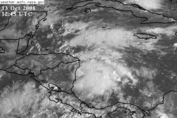
Is it stationary or moving?
Loop:
http://www.ssd.noaa.gov/goes/east/watl/loop-rb.html
Where will it go? Some clouds and squalls are being sucked north
across Florida, but the Low looks like it may go inland over the
Yucatan?
0 likes
-
Tampa Bay Hurricane
- Category 5
- Posts: 5597
- Age: 38
- Joined: Fri Jul 22, 2005 7:54 pm
- Location: St. Petersburg, FL
-
Tampa Bay Hurricane
- Category 5
- Posts: 5597
- Age: 38
- Joined: Fri Jul 22, 2005 7:54 pm
- Location: St. Petersburg, FL
Re: Area of disturbed weather in the western Caribbean
The posts in this forum are NOT official forecast and should not be used as such. They are just the opinion of the poster and may or may not be backed by sound meteorological data. They are NOT endorsed by any professional institution or storm2k.org. For official information, please refer to the NHC and NWS products.
Based on IR imagery, was moving W and then turned north, shooting north.

Based on IR imagery, was moving W and then turned north, shooting north.

0 likes
Re: Area of disturbed weather in the western Caribbean
Seeing surface rotation in 11.2N-82W area.
0 likes
-
Blown Away
- S2K Supporter
- Posts: 10253
- Joined: Wed May 26, 2004 6:17 am
Re: Area of disturbed weather in the western Caribbean
This area looks promising for development this morning, convection is building and there is rotation.
http://www.ssd.noaa.gov/goes/east/carb/loop-avn.html
http://www.ssd.noaa.gov/goes/east/carb/loop-avn.html
0 likes

Re: Area of disturbed weather in the western Caribbean
It looks like convection is on the increase but that high pressure building down the east coast would push this system west into Central America away from effecting South Florida.That high is expecting to take up shop right over Florida and shut down any shower activity and dry out the atmosphere this week.
0 likes
-
Blown Away
- S2K Supporter
- Posts: 10253
- Joined: Wed May 26, 2004 6:17 am
Re: Area of disturbed weather in the western Caribbean
boca wrote:It looks like convection is on the increase but that high pressure building down the east coast would push this system west into Central America away from effecting South Florida.That high is expecting to take up shop right over Florida and shut down any shower activity and dry out the atmosphere this week.
The TAFB keeps a low drifting around offshore through 72 hours.
http://www.nhc.noaa.gov/tafb_latest/atl ... BW_sm3.gif
0 likes


-
Blown Away
- S2K Supporter
- Posts: 10253
- Joined: Wed May 26, 2004 6:17 am
Re: Area of disturbed weather in the western Caribbean
IMO, we need a "Code Yellow" for this area. If this convection persists this morning I think we will see a "Code Yellow" this afternoon.
0 likes
Who is online
Users browsing this forum: OuterBanker, wwizard and 166 guests