Area of disturbed weather in SW Caribbean (Is invest 96L)

This is the general tropical discussion area. Anyone can take their shot at predicting a storms path.

Moderator: S2k Moderators

Forum rules

The posts in this forum are NOT official forecasts and should not be used as such. They are just the opinion of the poster and may or may not be backed by sound meteorological data. They are NOT endorsed by any professional institution or STORM2K. For official information, please refer to products from the National Hurricane Center and National Weather Service.

Help Support Storm2K
Message
Author
User avatar
gatorcane
S2K Supporter
S2K Supporter
Posts: 23692
Age: 47
Joined: Sun Mar 13, 2005 3:54 pm
Location: Boca Raton, FL

Area of disturbed weather in SW Caribbean (Is invest 96L)

#1 Postby gatorcane » Mon Nov 17, 2008 12:02 pm

I've been following the various global model runs over the past week. One thing that is interesting to note is that several of them are trying to form some kind of tropical low or broad area of low pressure in the extreme SW Caribbean just north of Panama. Interestingly enough this low is progged to form about 120 hours from now, or this weekend.

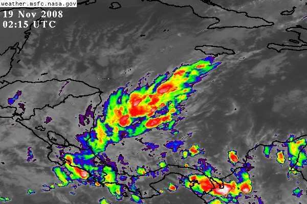
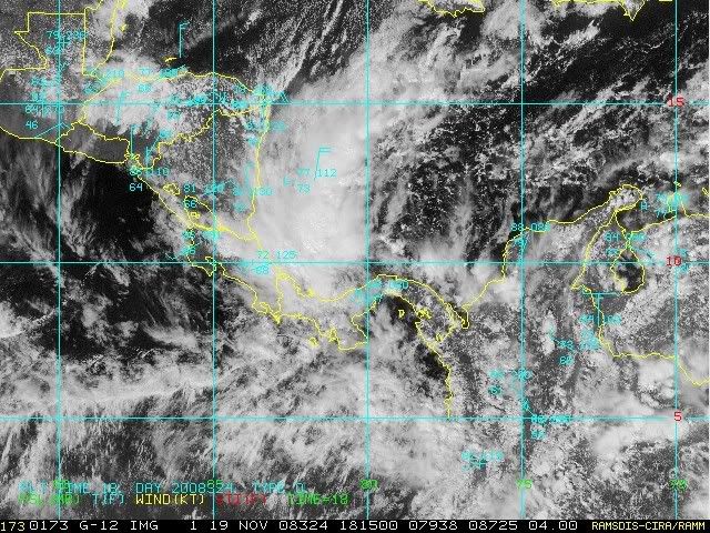
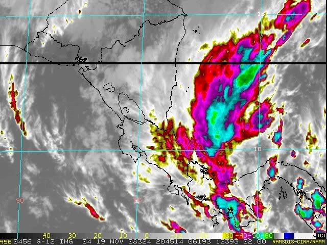
The synoptic setup that would form this low is similar to what formed Paloma. We have a powerful cold front pushing deep into the Western Caribbean (the one responsible for the colder than normal temperatures across the Eastern CONUS and Florida). This front remains stationary in the SW Caribbean sea over very warm SSTs.

The difference this time is that the models are not as "bullish" and they seem to want to drive this tropical low into Central America or into the EPAC. The latest 12Z GFS run, however, is the first run I have seen where it tries to drift it off to the north instead. The reason for the north drift in the 12Z run is probably because it develops a powerful cut-off low over the SE CONUS that would create a weakness.

I currently give this low about a 10% chance of forming and if it forms, more than likely will drift around the SW Caribbean or push into Central America. Nonetheless, it is about the only area of interest out there at this time.

GFS at 120 hours:
Image

GFS at 336 hours:
Image
0 likes   

User avatar
HURAKAN
Professional-Met
Professional-Met
Posts: 46086
Age: 38
Joined: Thu May 20, 2004 4:34 pm
Location: Key West, FL
Contact:

#2 Postby HURAKAN » Mon Nov 17, 2008 12:24 pm

Image
0 likes   

User avatar
DESTRUCTION5
Category 5
Category 5
Posts: 4423
Age: 43
Joined: Wed Sep 03, 2003 11:25 am
Location: Stuart, FL

#3 Postby DESTRUCTION5 » Mon Nov 17, 2008 12:55 pm

You did not just start another WC thread... :lol:
0 likes   

User avatar
gatorcane
S2K Supporter
S2K Supporter
Posts: 23692
Age: 47
Joined: Sun Mar 13, 2005 3:54 pm
Location: Boca Raton, FL

Re:

#4 Postby gatorcane » Mon Nov 17, 2008 12:59 pm

DESTRUCTION5 wrote:You did not just start another WC thread... :lol:


Indeed I did :)

albeit I am only giving this area a 10% chance of development

12Z UKM at shows a broad area of low pressure with a weak area of low pressure trying to form in the extreme SW
Caribbean. The UKM is a fairly accurate model in predicting cyclogenesis as it usually is "conservative" so if it is showing some area of low pressure, albeit weak, chances improve its going to develop. Whether it actually develops into something tropical is still unclear at the moment.

Image
0 likes   

Frank2
Category 5
Category 5
Posts: 4061
Joined: Mon Jul 25, 2005 12:47 pm

Re: Long-Range Models Hinting at Tropical Low in SW Caribbean

#5 Postby Frank2 » Mon Nov 17, 2008 1:03 pm

I was wondering about that...

That area is favorable for development year-round, but, once anything moves north of 20N, that's it (per Paloma)...

A TS did form down there in February of 1952, if I'm not mistaken, and, moved north to make landfall as a TS near Tampa, so, you never know...
0 likes   

User avatar
Hurricanehink
S2K Supporter
S2K Supporter
Posts: 2040
Joined: Sun Nov 16, 2003 2:05 pm
Location: New Jersey

Re: Long-Range Models Hinting at Tropical Low in SW Caribbean

#6 Postby Hurricanehink » Mon Nov 17, 2008 2:29 pm

Might Hurricane Martha of 1969 be an analog? Look at the time of year and location. Food for thought.

Image
0 likes   

User avatar
wxman57
Moderator-Pro Met
Moderator-Pro Met
Posts: 22984
Age: 67
Joined: Sat Jun 21, 2003 8:06 pm
Location: Houston, TX (southwest)

Re: Long-Range Models Hinting at Tropical Low in SW Caribbean

#7 Postby wxman57 » Mon Nov 17, 2008 4:37 pm

Frank2 wrote:I was wondering about that...

That area is favorable for development year-round, but, once anything moves north of 20N, that's it (per Paloma)...

A TS did form down there in February of 1952, if I'm not mistaken, and, moved north to make landfall as a TS near Tampa, so, you never know...


GFS would suggest anything north of 15N is history now. And I'd estimate the chances of development as less than 1% rather than 10%. This season is over.
0 likes   

Ed Mahmoud

Re: Long-Range Models Hinting at Tropical Low in SW Caribbean

#8 Postby Ed Mahmoud » Mon Nov 17, 2008 4:48 pm

wxman57 wrote:
Frank2 wrote:I was wondering about that...

That area is favorable for development year-round, but, once anything moves north of 20N, that's it (per Paloma)...

A TS did form down there in February of 1952, if I'm not mistaken, and, moved north to make landfall as a TS near Tampa, so, you never know...


GFS would suggest anything north of 15N is history now. And I'd estimate the chances of development as less than 1% rather than 10%. This season is over.


Probably, but with GFS showing not a hint of winter precip in SE Texas the next 2 weeks, we have to watch something.
0 likes   

User avatar
gatorcane
S2K Supporter
S2K Supporter
Posts: 23692
Age: 47
Joined: Sun Mar 13, 2005 3:54 pm
Location: Boca Raton, FL

Re: Long-Range Models Hinting at Tropical Low in SW Caribbean

#9 Postby gatorcane » Tue Nov 18, 2008 11:39 am

wxman57 wrote:
Frank2 wrote:I was wondering about that...

That area is favorable for development year-round, but, once anything moves north of 20N, that's it (per Paloma)...

A TS did form down there in February of 1952, if I'm not mistaken, and, moved north to make landfall as a TS near Tampa, so, you never know...


GFS would suggest anything north of 15N is history now. And I'd estimate the chances of development as less than 1% rather than 10%. This season is over.


Looking at model support over the past 12-18 hours and seeing them back off more on this area, I now give it a 1% chance of developing.

I do agree with you the Atlantic hurricane season is over. There is a remote possibility of something forming way out in the Central Atlantic -- probably of STS origins but looks like 2008 has ended.
0 likes   

User avatar
HURAKAN
Professional-Met
Professional-Met
Posts: 46086
Age: 38
Joined: Thu May 20, 2004 4:34 pm
Location: Key West, FL
Contact:

#10 Postby HURAKAN » Tue Nov 18, 2008 9:41 pm

Image
0 likes   

User avatar
HURAKAN
Professional-Met
Professional-Met
Posts: 46086
Age: 38
Joined: Thu May 20, 2004 4:34 pm
Location: Key West, FL
Contact:

#11 Postby HURAKAN » Wed Nov 19, 2008 10:11 am

Image

Quite persistent.
0 likes   

Derek Ortt

#12 Postby Derek Ortt » Wed Nov 19, 2008 10:46 am

no cyclones are permitted to form or exist within 3 days of Thanksgiving.

I have plans that week-end, which are slightly more important than a TC (and by slightly, I mean a LOT)
0 likes   

Ed Mahmoud

Re:

#13 Postby Ed Mahmoud » Wed Nov 19, 2008 11:08 am

Derek Ortt wrote:no cyclones are permitted to form or exist within 3 days of Thanksgiving.

I have plans that week-end, which are slightly more important than a TC (and by slightly, I mean a LOT)


You don't have a laptop and the ability to upload to the NHCC or whatever it is called? That other guy named Judt, it isn't his weekend? Do you even get paid for that?


I'm much more concerned by 15 years and counting since the last snow and sleet Thanksgiving Cowboys game.
0 likes   

User avatar
gatorcane
S2K Supporter
S2K Supporter
Posts: 23692
Age: 47
Joined: Sun Mar 13, 2005 3:54 pm
Location: Boca Raton, FL

Re: Long-Range Models Hinting at Tropical Low in SW Caribbean

#14 Postby gatorcane » Wed Nov 19, 2008 11:51 am

Models are still hinting at the possibility of something forming but they don't seem overly enthusiastic. A small chance exists still and the convection has been persistent so we shall see.
0 likes   

Sanibel
Category 5
Category 5
Posts: 10375
Joined: Mon Aug 30, 2004 11:06 pm
Location: Offshore SW Florida

Re: Long-Range Models Hinting at Tropical Low in SW Caribbean

#15 Postby Sanibel » Wed Nov 19, 2008 12:25 pm

It has the same look and set-up as Paloma. A Panama Low forming under a cold front.


GHCC always makes disturbances look stronger than they are. I'd bet against this one.
0 likes   

User avatar
HURAKAN
Professional-Met
Professional-Met
Posts: 46086
Age: 38
Joined: Thu May 20, 2004 4:34 pm
Location: Key West, FL
Contact:

#16 Postby HURAKAN » Wed Nov 19, 2008 1:51 pm

Image

This system is claiming to some interest from the NHC as a floater is being placed over the disturbance.
0 likes   

User avatar
boca
Category 5
Category 5
Posts: 6368
Age: 60
Joined: Mon Dec 15, 2003 8:49 am
Location: Boca Raton,FL

Re: Long-Range Models Hinting at Tropical Low in SW Caribbean

#17 Postby boca » Wed Nov 19, 2008 2:18 pm

This potential system has the look.I would bet that something although weak might come out of it.
0 likes   

Derek Ortt

Re: Re:

#18 Postby Derek Ortt » Wed Nov 19, 2008 3:29 pm

Ed Mahmoud wrote:
Derek Ortt wrote:no cyclones are permitted to form or exist within 3 days of Thanksgiving.

I have plans that week-end, which are slightly more important than a TC (and by slightly, I mean a LOT)


You don't have a laptop and the ability to upload to the NHCC or whatever it is called? That other guy named Judt, it isn't his weekend? Do you even get paid for that?


I'm much more concerned by 15 years and counting since the last snow and sleet Thanksgiving Cowboys game.


I said, I have more important plans. I'd have to dump everything off onto Judt.

If it hits the keys, well... lets just say you'll be stuck with one very unhappy Ortt
0 likes   

Frank2
Category 5
Category 5
Posts: 4061
Joined: Mon Jul 25, 2005 12:47 pm

Re: Long-Range Models Hinting at Tropical Low in SW Caribbean

#19 Postby Frank2 » Wed Nov 19, 2008 3:44 pm

Far out - I guessed 1952 and that was correct (I have to be right at least once per season):

http://www.weather.unisys.com/hurricane ... index.html

the Western Caribbean is almost always favorable for some type of development, but, not every year - per the '52 system, it's track is more similar to early October, so, it just depends...

Frank
0 likes   

User avatar
HURAKAN
Professional-Met
Professional-Met
Posts: 46086
Age: 38
Joined: Thu May 20, 2004 4:34 pm
Location: Key West, FL
Contact:

#20 Postby HURAKAN » Wed Nov 19, 2008 4:36 pm

Image

Image

A tropical wave should interact with this system in the next 24 hours.
0 likes   


Return to “Talkin' Tropics”

Who is online

Users browsing this forum: abajan, Google Adsense [Bot], Hurricane2000, Hypercane_Kyle, jhpigott, Majestic-12 [Bot], NotSparta, ScottNAtlanta, wwizard and 86 guests