I dont remember a very long paragrafh like this one made only for the ITCZ.The only word I have for it is
WOW!000
AXNT20 KNHC 151045
TWDAT
TROPICAL WEATHER DISCUSSION
NWS TPC/NATIONAL HURRICANE CENTER MIAMI FL
805 AM EDT WED APR 15 2009
TROPICAL WEATHER DISCUSSION FOR NORTH AMERICA...CENTRAL
AMERICA...GULF OF MEXICO...CARIBBEAN SEA...NORTHERN SECTIONS
OF SOUTH AMERICA...AND ATLANTIC OCEAN TO THE AFRICAN COAST
FROM THE EQUATOR TO 32N. THE FOLLOWING INFORMATION IS BASED
ON SATELLITE IMAGERY...METEOROLOGICAL ANALYSIS...WEATHER
OBSERVATIONS...AND RADAR.
BASED ON 0600 UTC SURFACE ANALYSIS AND SATELLITE IMAGERY
THROUGH 1015 UTC.
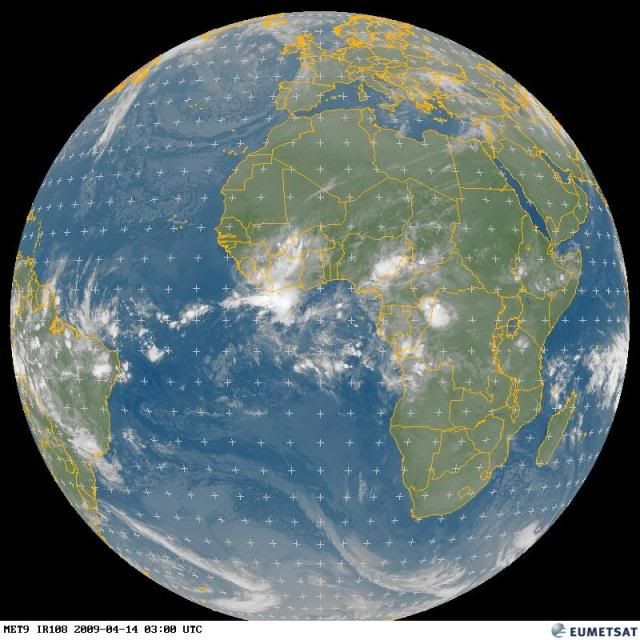
...THE ITCZ...
FROM 5N8W AT THE SOUTHERN COAST OF LIBERIA...CROSSING THE
EQUATOR ALONG 18W TO 3S30W.....AND GOING INTO NORTHEASTERN
BRAZIL NEAR 2S45W. A SURFACE TROUGH WAS ANALYZED ALONG 13W AT
15/0000 UTC. I STUDIED ALL THE AVAILABLE METEOSAT-9 VISIBLE
SATELLITE FROM 14/0930 UTC UNTIL 14/1645 UTC AND I SAW ONLY
A SMALL AMOUNT OF CYCLONIC TURNING AT AN UNKNOWN LEVEL IN THE
ATMOSPHERE NEAR 2N17W AT THE END OF THAT CYCLE OF IMAGES.
I SAW A SOLID FIELD OF LOW CLOUDS IN THAT CYCLE OF VISIBLE
IMAGES MOVING FROM THE AREA TO THE SOUTH OF THE EQUATOR TOWARD
THE ITCZ...WITHOUT CYCLONIC TURNING. I AM INCLINED NOT TO
BELIEVE THAT A SURFACE TROUGH EXISTED AT THE TIME THAT IT WAS
ADDED TO THE MAP AND WHERE IT WAS PUT ON THE MAP ANALYSIS
YESTERDAY. THAT IS NOT TO SAY THAT A SURFACE TROUGH MAY NOT
FORM AT SOME TIME IN THE FUTURE IN THE ITCZ. I HAVE STUDIED
THE LATEST METEOSAT-9 VISIBLE IMAGERY THIS MORNING AND I AM
CONVINCED THAT NO SURFACE TROUGH IS IN THE ITCZ AT THIS TIME.
STRONG SHOWERS AND THUNDERSTORMS ARE AWAY FROM THE ITCZ AT
THIS TIME...FROM THE EQUATOR TO 3N BETWEEN THE PRIME MERIDIAN
AND 4W. ISOLATED AND DISORGANIZED MODERATE SHOWERS AND POSSIBLE
THUNDERSTORMS ARE TO THE SOUTH OF 6N BETWEEN 10W AND 45W.
http://www.storm2k.org/weather/hw3.php? ... hwvmetric=