Possible Subtropical Cyclone near the Azores

This is the general tropical discussion area. Anyone can take their shot at predicting a storms path.

Moderator: S2k Moderators

Forum rules

The posts in this forum are NOT official forecasts and should not be used as such. They are just the opinion of the poster and may or may not be backed by sound meteorological data. They are NOT endorsed by any professional institution or STORM2K. For official information, please refer to products from the National Hurricane Center and National Weather Service.

Help Support Storm2K
Message
Author
User avatar
HURAKAN
Professional-Met
Professional-Met
Posts: 46086
Age: 38
Joined: Thu May 20, 2004 4:34 pm
Location: Key West, FL
Contact:

Possible Subtropical Cyclone near the Azores

#1 Postby HURAKAN » Mon Jun 01, 2009 10:55 am

Image

Image

Image

Image

Incredible!
0 likes   

User avatar
Chacor
Category 5
Category 5
Posts: 10229
Joined: Mon Oct 02, 2006 10:43 pm
Location: Singapore

#2 Postby Chacor » Mon Jun 01, 2009 10:58 am

That does look very nice.
0 likes   

RL3AO
Moderator-Pro Met
Moderator-Pro Met
Posts: 16308
Joined: Thu Jun 14, 2007 10:03 pm
Location: NC

#3 Postby RL3AO » Mon Jun 01, 2009 10:59 am

June fools day? That looks really good.
0 likes   

User avatar
HURAKAN
Professional-Met
Professional-Met
Posts: 46086
Age: 38
Joined: Thu May 20, 2004 4:34 pm
Location: Key West, FL
Contact:

#4 Postby HURAKAN » Mon Jun 01, 2009 10:59 am

0 likes   

User avatar
HURAKAN
Professional-Met
Professional-Met
Posts: 46086
Age: 38
Joined: Thu May 20, 2004 4:34 pm
Location: Key West, FL
Contact:

Re:

#5 Postby HURAKAN » Mon Jun 01, 2009 11:00 am

RL3AO wrote:June fools day? That looks really good.


No joke. I am as impressed as you are.
0 likes   

User avatar
Chacor
Category 5
Category 5
Posts: 10229
Joined: Mon Oct 02, 2006 10:43 pm
Location: Singapore

#6 Postby Chacor » Mon Jun 01, 2009 11:09 am

Not quite a gale system, according to Meteo-France.

http://twister.sbs.ohio-state.edu/text/ ... QNT50.LFPW

Part 1 : NO WARNING.

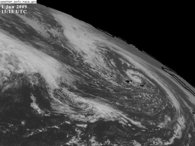
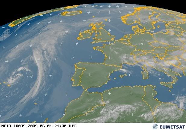
Part 2 : General synopsis, Monday 1 at 00 UTC

Low 1001 39N28W moving north, expected 999 44N24W by 02/12UTC.

Part 3 : Area forecasts to Tuesday 2 at 12 UTC

ALTAIR :
In west, Northerly 6 or 7 backing North or Northwest 5 or 6 later.
In east, East or Southeast 3 to 5 becoming cyclonic 5 to 7 soon.
Rough or very rough in west, and moderate or rough in east.
Thundery rain or showers. Severe gusts.

ACORES :
In extreme east, South or Southwest 6 or 7 gradually veering West
or Southwest 4 to 6. Elsewhere, Northwesterly 4 to 6. Moderate or
rough, locally very rough in west. Thundery rain or showers.
Gusts.

Force 8 is a gale.
0 likes   

User avatar
TheEuropean
Professional-Met
Professional-Met
Posts: 1796
Age: 59
Joined: Tue Sep 20, 2005 3:17 pm
Location: Voerde, Germany
Contact:

Re: Possible Subtropical Cyclone near the Azores

#7 Postby TheEuropean » Mon Jun 01, 2009 11:14 am

Looks very impressive to me. SST are only 17 to 18 Celsius, some degrees below temperatures when Epsilon, Zeta, Vince etc. made their way near Azores ans Canaries.
0 likes   

User avatar
HURAKAN
Professional-Met
Professional-Met
Posts: 46086
Age: 38
Joined: Thu May 20, 2004 4:34 pm
Location: Key West, FL
Contact:

#8 Postby HURAKAN » Mon Jun 01, 2009 11:35 am

Image
0 likes   

User avatar
cycloneye
Admin
Admin
Posts: 145619
Age: 68
Joined: Thu Oct 10, 2002 10:54 am
Location: San Juan, Puerto Rico

Re: Possible Subtropical Cyclone near the Azores

#9 Postby cycloneye » Mon Jun 01, 2009 11:37 am

The 12 UTC surface analysis shows the low at 1002 mbs.

Image
0 likes   

User avatar
wxman57
Moderator-Pro Met
Moderator-Pro Met
Posts: 22984
Age: 67
Joined: Sat Jun 21, 2003 8:06 pm
Location: Houston, TX (southwest)

Re: Possible Subtropical Cyclone near the Azores

#10 Postby wxman57 » Mon Jun 01, 2009 11:54 am

Just a cold core low over cold water, and probably won't be more than that. Currently, max winds of 35-40 kts are located between 400-500nm NW of the center with 30-35 kt winds about 300 miles NE-SE of the center. Winds within 100 miles of the center are closer to 20-30 kts.
0 likes   

User avatar
Category 5
Category 5
Category 5
Posts: 10074
Age: 35
Joined: Sun Feb 11, 2007 10:00 pm
Location: New Brunswick, NJ
Contact:

Re: Possible Subtropical Cyclone near the Azores

#11 Postby Category 5 » Mon Jun 01, 2009 1:05 pm

Are there any upper level temperature anomalies? If so it would have a case.
0 likes   

User avatar
Cainer
Tropical Storm
Tropical Storm
Posts: 188
Age: 34
Joined: Mon May 05, 2008 3:26 pm
Location: Yarmouth, Nova Scotia

#12 Postby Cainer » Mon Jun 01, 2009 1:53 pm

SSD has a floater on it now:

Image

Convection isn't all that deep, but not bad for being over such cold waters.
0 likes   

User avatar
cycloneye
Admin
Admin
Posts: 145619
Age: 68
Joined: Thu Oct 10, 2002 10:54 am
Location: San Juan, Puerto Rico

Re: Possible Subtropical Cyclone near the Azores

#13 Postby cycloneye » Mon Jun 01, 2009 2:22 pm

It got SSD T numbers.

01/1745 UTC 39.9N 24.7W T1.5/1.5 INVEST -- Atlantic
0 likes   

Cyclone1
Category 5
Category 5
Posts: 2739
Age: 33
Joined: Tue Jun 12, 2007 12:03 pm
Location: Florida

#14 Postby Cyclone1 » Mon Jun 01, 2009 2:27 pm

Wow, this is pretty cool. Very impressive, nice catch Hurakan!

92L in the near future?
0 likes   

Aric Dunn
Category 5
Category 5
Posts: 21238
Age: 42
Joined: Sun Sep 19, 2004 9:58 pm
Location: Ready for the Chase.
Contact:

#15 Postby Aric Dunn » Mon Jun 01, 2009 2:28 pm

ok thats is interesting.,.. i guess by definition..

would be sub tropical as long as the temp gradient is such that it does not get colder the closer you get...

well i guess in that case it could be a warm core ( not saying it is) if the temp gradient increases the closer you get to the center even if it is in the 50's and 60's

lol :double:
0 likes   

Aric Dunn
Category 5
Category 5
Posts: 21238
Age: 42
Joined: Sun Sep 19, 2004 9:58 pm
Location: Ready for the Chase.
Contact:

#16 Postby Aric Dunn » Mon Jun 01, 2009 2:32 pm

check out the evolution of this thing....

http://www.ssd.noaa.gov/eumet/neatl/loop-wv.html
0 likes   

Aric Dunn
Category 5
Category 5
Posts: 21238
Age: 42
Joined: Sun Sep 19, 2004 9:58 pm
Location: Ready for the Chase.
Contact:

Re: Possible Subtropical Cyclone near the Azores

#17 Postby Aric Dunn » Mon Jun 01, 2009 2:40 pm

well...

GFS makes it sub trop....

Image


and the UKMET

Image
0 likes   

User avatar
HURAKAN
Professional-Met
Professional-Met
Posts: 46086
Age: 38
Joined: Thu May 20, 2004 4:34 pm
Location: Key West, FL
Contact:

#18 Postby HURAKAN » Mon Jun 01, 2009 4:29 pm

Earlier:

Image

Image
0 likes   

User avatar
HURAKAN
Professional-Met
Professional-Met
Posts: 46086
Age: 38
Joined: Thu May 20, 2004 4:34 pm
Location: Key West, FL
Contact:

#19 Postby HURAKAN » Mon Jun 01, 2009 4:38 pm

Image
0 likes   

Ed Mahmoud

Re: Possible Subtropical Cyclone near the Azores

#20 Postby Ed Mahmoud » Mon Jun 01, 2009 5:06 pm

Sink or swim time. It looks like it has completely occluded, the GFS shows the parent 500 mb low slowly weakening through the next 3 days, and weakens the surface low along with it.


Being occluded, it has lost a direct connection to higher moisture/temperature (I'd use a fancy term like Θe or equivalent temperature, but as an rank amateur, that would just be presumptuous) so it is hard to see how it can maintain thunderstorms over water temps in the 60s for very long.
0 likes   


Return to “Talkin' Tropics”

Who is online

Users browsing this forum: flstorms, gib, Google [Bot], OuterBanker, zzzh and 399 guests