Ok, I hope this comes out the way I intend for it to. NOT as a chance to bash someone, but a chance to put the meteorological think tank that we have assembled here to work. Seriously. This is important, so here I go.
Joe Bastardi says as clear as a bell that the system hitting New Jersey and vicinity is a tropical cyclone. He leaves nothing to hide in that distinction. I am not going to argue one way or another as I am not a meteorologist. I do have eyes and can see some of the features he sees and understand his reasoning. But I wonder then why the professionals at the NHC would not classify this is a tropical cyclone or even a sub-tropical cyclone.
So, is Joe Bastardi right? If so, why? If not, why?
Is Joe right?
Moderator: S2k Moderators
Forum rules

The posts in this forum are NOT official forecasts and should not be used as such. They are just the opinion of the poster and may or may not be backed by sound meteorological data. They are NOT endorsed by any professional institution or STORM2K. For official information, please refer to products from the National Hurricane Center and National Weather Service.
-
hurricanetrack

- HurricaneTrack.com

- Posts: 1781
- Joined: Tue Dec 02, 2003 10:46 pm
- Location: Wilmington, NC
- Contact:
Is Joe right?
0 likes
-
terstorm1012

- S2K Supporter

- Posts: 1314
- Age: 44
- Joined: Fri Sep 10, 2004 5:36 pm
- Location: Millersburg, PA
Re: Is Joe right?
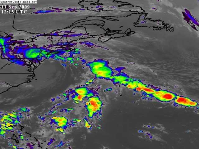
I'd be curious to see what he sees too. On satellite it looks like a nor'easter.
0 likes

-
terstorm1012
- S2K Supporter
- Posts: 1314
- Age: 44
- Joined: Fri Sep 10, 2004 5:36 pm
- Location: Millersburg, PA
Re: Is Joe right?
http://moe.met.fsu.edu/cyclonephase/cmc ... 00/11.html A number of the models seem to indicate it's warm core.
I'm a bit west of the worst and I can tell you that it feels like a nor'easter. It's cold, clammy, damp. When Hanna came through last year around this time the air was a lot warmer. Just an observation.
I'm a bit west of the worst and I can tell you that it feels like a nor'easter. It's cold, clammy, damp. When Hanna came through last year around this time the air was a lot warmer. Just an observation.
0 likes
-
wxman57

- Moderator-Pro Met

- Posts: 23176
- Age: 68
- Joined: Sat Jun 21, 2003 8:06 pm
- Location: Houston, TX (southwest)
Re: Is Joe right?
He does make a very good point that it should be classified at least as a subtropical storm. Convection began firing over the center yesterday. If you check the various phase diagrams (CMC, UKMET, GFS, ECMWF), then all of them identified the low as a symmetric warm core system 00Z last evening. And all of them had it transitioning to symmetric cold core by today. I think that this low would qualify for naming, given the subtropical storms the NHC has named since 2000.

0 likes
-
hurricanetrack
- HurricaneTrack.com
- Posts: 1781
- Joined: Tue Dec 02, 2003 10:46 pm
- Location: Wilmington, NC
- Contact:
I cannot post his writings here for obvious reasons but he is very clear in calling it a tropical cyclone. He says that is what it is and that he is sorry he missed it along the coast- he wishes he could have been there.
Again, I am not trying to bring down the man or make him out to be a clown but if he is calling it a tropical cyclone in his blog, is he also saying that on the radio, if he is doing any live radio today? And if he is, then is this okay to do in the face of the official word from the NHC. Or, does one have the right to say what ever they wish so long as it does not endanger public safety? This is an important topic and I will be curious to see what people say.
Again, I am not trying to bring down the man or make him out to be a clown but if he is calling it a tropical cyclone in his blog, is he also saying that on the radio, if he is doing any live radio today? And if he is, then is this okay to do in the face of the official word from the NHC. Or, does one have the right to say what ever they wish so long as it does not endanger public safety? This is an important topic and I will be curious to see what people say.
0 likes
-
HURAKAN

- Professional-Met

- Posts: 46084
- Age: 39
- Joined: Thu May 20, 2004 4:34 pm
- Location: Key West, FL
- Contact:
To tell you the truth, the system last year that made landfall in NC that was not classified looked more tropical than this system. Also, the system that we had in May looked more tropical. In the images you can still see the cold front and the cold air being dragged over the ocean. Also, this system has never been able to maintain an area of convection near the center for a long period of time. In my own, personal opinion, this system looks more non-tropical than subtropical.
0 likes
-
Dean4Storms
- S2K Supporter
- Posts: 6358
- Age: 63
- Joined: Sun Aug 31, 2003 1:01 pm
- Location: Miramar Bch. FL
Re:
hurricanetrack wrote:I cannot post his writings here for obvious reasons but he is very clear in calling it a tropical cyclone. He says that is what it is and that he is sorry he missed it along the coast- he wishes he could have been there.
Again, I am not trying to bring down the man or make him out to be a clown but if he is calling it a tropical cyclone in his blog, is he also saying that on the radio, if he is doing any live radio today? And if he is, then is this okay to do in the face of the official word from the NHC. Or, does one have the right to say what ever they wish so long as it does not endanger public safety? This is an important topic and I will be curious to see what people say.
Last I heard this is still a free country even for Meteorologists. He has a right to his opinion as far as I see it and his interpretation as to whether it was tropical or not does not endanger anyone.
0 likes
-
wxman57
- Moderator-Pro Met
- Posts: 23176
- Age: 68
- Joined: Sat Jun 21, 2003 8:06 pm
- Location: Houston, TX (southwest)
Re: Is Joe right?
One other point he made, the temperature at buoy offshore Delaware Bay rose 5-6 degrees as the center passed this morning. I certainly do see evidence of a warm core - more so yesterday afternoon/evening than now. But I think the NHC missed one here. If they're going to name those questionable lows in March, April and May, then why not such a storm in peak hurricane season when SSTs are a lot warmer?
http://www.ndbc.noaa.gov/station_page.php?station=44009
http://www.ndbc.noaa.gov/station_page.php?station=44009
0 likes
-
hurricanetrack
- HurricaneTrack.com
- Posts: 1781
- Joined: Tue Dec 02, 2003 10:46 pm
- Location: Wilmington, NC
- Contact:
-
brunota2003

- S2K Supporter
- Posts: 9476
- Age: 35
- Joined: Sat Jul 30, 2005 9:56 pm
- Location: Stanton, KY...formerly Havelock, NC
- Contact:
Re: Is Joe right?
He has a right to his opinion as far as I see it and his interpretation as to whether it was tropical or not does not endanger anyone.
A few years ago the AMS told me something very similar about JB and meteorologists like him - they'd prefer that meteorologists not be known as people that "cry wolf" or sensationalize the weather, and that as professionals they hope that he and others like him would know right from wrong when it comes to interpreting the weather for public consumption...
Personally, my guess is that this system is another hybrid - but is mostly non-tropical, since the wind is due to the pressure gradient more than anything...
Frank
0 likes
-
hurricanetrack
- HurricaneTrack.com
- Posts: 1781
- Joined: Tue Dec 02, 2003 10:46 pm
- Location: Wilmington, NC
- Contact:
HURAKN- yes, you can clearly see the front, what looks like CAA coming off the NC mainland over the ocean and the dry slug coming up the system like a classic Nor'easter. Its center may be warmer than the surrounding environment, but it does not look like a sub tropical or tropical storm. However, since the effects were and still are fairly substantial, perhaps there needs to be a way to include these in to the definitions. Maybe not. Maybe the "special update" clause is enough and if people were just more aware of the weather it would not be a big surprise.
0 likes
-
wxman57
- Moderator-Pro Met
- Posts: 23176
- Age: 68
- Joined: Sat Jun 21, 2003 8:06 pm
- Location: Houston, TX (southwest)
Re: Is Joe right?
It's clearly transitioning to nontropical now. But look at the data from last evening. I think it was a subtropical storm and should have been named, given previous such systems that were named over cold water during the off-season. Joe's right on this one.
0 likes
-
hurricanetrack
- HurricaneTrack.com
- Posts: 1781
- Joined: Tue Dec 02, 2003 10:46 pm
- Location: Wilmington, NC
- Contact:
Thanks for the thoughts. I am always interested in what the perception is, the science and the impact overall. Again, not trying to roll up Joe or anything. Perhaps this system will get added in post season analysis? The Sept. 2008 no-named storm was WAY more organized than this and it did not get added. So who knows.
0 likes

-
HurricaneBelle

- S2K Supporter
- Posts: 1209
- Joined: Sun Aug 27, 2006 6:12 pm
- Location: Clearwater, FL
Re: Is Joe right?
Note these obs, the lower the pressure the higher the dewpoint. Rio Grande is the lowest pressure, with a 70 DP, the rest of SNJ is in the mid-upper 60s, while you get further away everyone is in the 50s:
SOUTHERN NEW JERSEY
CITY SKY/WX TMP DP RH WIND PRES REMARKS
POMONA HVY RAIN 69 67 93 E22G32 29.91R VSB 1
RIO GRANDE* CLOUDY 70 70 100 MISG 29.82F
MILLVILLE HVY RAIN 64 62 93 N14G26 29.86F FOG
WRIGHTSTOWN LGT RAIN 62 61 97 NE24G32 29.98F FOG
LAKEHURST HVY RAIN 64 60 87 NE20G33 30.01F FOG
MOUNT HOLLY LGT RAIN 60 58 92 NE18G30 29.98F FOG
TRENTON RAIN 59 56 89 NE15G29 30.05F FOG
NJZ001>014-111500-
NORTHERN NEW JERSEY
CITY SKY/WX TMP DP RH WIND PRES REMARKS
SUSSEX CLOUDY 54 50 86 NE20G31 30.21F
ANDOVER* N/A 53 52 96 NE10G18 30.19F
MORRISTOWN DRIZZLE 57 55 94 NE13G25 30.16F FOG
NEWARK LGT RAIN 59 54 83 NE21G36 30.13F
TETERBORO LGT RAIN 60 55 83 NE8G20 30.16S
CALDWELL LGT RAIN 57 54 88 NE8G22 30.17F FOG
SOMERVILLE LGT RAIN 57 55 94 NE14G25 30.09F FOG
ALLAIRE* CLOUDY 63 61 94 NE28G40 30.03F
TOMS RIVER* CLOUDY 64 63 94 NE20G33 29.99F
PAZ043-044-047-054-055-060>062-066>071-111500-
EASTERN PENNSYLVANIA
CITY SKY/WX TMP DP RH WIND PRES REMARKS
PHILADELPHIA LGT RAIN 61 57 88 NE33G45 29.97F
NORTH PHILA LGT RAIN 59 56 89 NE26G35 30.04F
WILLOW GROVE CLOUDY 57 53 86 NE18G35 30.06S
BLUE BELL CLOUDY 58 57 94 NE14G23 30.03F
DOYLESTOWN CLOUDY 57 56 96 NE16G28 30.07S
QUAKERTOWN* CLOUDY 54 54 100 NE14G24 30.10S
POTTSTOWN CLOUDY 57 54 89 N12G23 30.08F
LANCASTER RAIN 58 55 90 N16 30.10F
COATESVILLE CLOUDY 54 54 100 N13G23 30.06F FOG
READING RAIN 57 55 94 N12 30.09F FOG
ALLENTOWN LGT RAIN 56 54 93 NE17 30.13F
MOUNT POCONO LGT RAIN 54 52 94 NE22G30 30.19F FOG
WILKES BARRE LGT RAIN 55 53 93 NE7 30.21F
0 likes
-
Derek Ortt
Re: Is Joe right?
hurricanetrack wrote:Ok, I hope this comes out the way I intend for it to. NOT as a chance to bash someone, but a chance to put the meteorological think tank that we have assembled here to work. Seriously. This is important, so here I go.
Joe Bastardi says as clear as a bell that the system hitting New Jersey and vicinity is a tropical cyclone. He leaves nothing to hide in that distinction. I am not going to argue one way or another as I am not a meteorologist. I do have eyes and can see some of the features he sees and understand his reasoning. But I wonder then why the professionals at the NHC would not classify this is a tropical cyclone or even a sub-tropical cyclone.
So, is Joe Bastardi right? If so, why? If not, why?
he is doing what he always does. He is trying to trash the NHC even when the science clearly disagrees with him
The system was trying to transition. However, the definition of both subtropical and tropical cyclones includes them being NON FRONTAL. This was always somewhat attached to the front; thus, not a named storm. Only thing this storm is good for was delaying the Nadal match...
0 likes
-
HURAKAN
- Professional-Met
- Posts: 46084
- Age: 39
- Joined: Thu May 20, 2004 4:34 pm
- Location: Key West, FL
- Contact:
Re:
brunota2003 wrote:Can you name a system as subtropical when it has fronts attached to it, and is not shedding them?
Tropical and subtropical systems need to be non-frontal. That's why I politely disagree with JB and wxman57.
Subtropical Cyclone:
A non-frontal low pressure system that has characteristics of both tropical and extratropical cyclones. This system is typically an upper-level cold low with circulation extending to the surface layer and maximum sustained winds generally occurring at a radius of about 100 miles or more from the center. In comparison to tropical cyclones, such systems have a relatively broad zone of maximum winds that is located farther from the center, and typically have a less symmetric wind field and distribution of convection.
Tropical Cyclone:
A warm-core non-frontal synoptic-scale cyclone, originating over tropical or subtropical waters, with organized deep convection and a closed surface wind circulation about a well-defined center. Once formed, a tropical cyclone is maintained by the extraction of heat energy from the ocean at high temperature and heat export at the low temperatures of the upper troposphere. In this they differ from extratropical cyclones, which derive their energy from horizontal temperature contrasts in the atmosphere (baroclinic effects).
Link: http://www.nhc.noaa.gov/aboutgloss.shtml#SUBCYC
0 likes
Who is online
Users browsing this forum: Ulf and 217 guests