Western Caribbean / SW Gulf Development??
Moderator: S2k Moderators
Forum rules

The posts in this forum are NOT official forecasts and should not be used as such. They are just the opinion of the poster and may or may not be backed by sound meteorological data. They are NOT endorsed by any professional institution or STORM2K. For official information, please refer to products from the National Hurricane Center and National Weather Service.
-
wxman57

- Moderator-Pro Met

- Posts: 23176
- Age: 68
- Joined: Sat Jun 21, 2003 8:06 pm
- Location: Houston, TX (southwest)
Western Caribbean / SW Gulf Development??
You guys must be asleep. Can't believe that no one here has posted anything on the big area of thunderstorms in the western Caribbean. Pressures in the area are very low - 1008-1009MB. Wind shear is a bit high but forecast to decrease tomorrow. I'm not saying that development is likely, just that it gets MY attention on satellite. Should move slowly westward over the next few days, maybe into the BoC or SW Gulf.
0 likes


Re: Westeren Caribbean / SW Gulf Development??
Good call...I guess we disillusioned amateurs were asleep at the wheel. The area definitely did get my interest this morning, and it should be worth watching.
0 likes

-
frederic79

- Category 1

- Posts: 271
- Joined: Sun Jul 18, 2004 8:48 pm
- Location: Grand Bay, AL
Re: Westeren Caribbean / SW Gulf Development??
Guilty of being lulled to sleep by watching ex-Fred for 2 weeks.
0 likes

Re: Westeren Caribbean / SW Gulf Development??
Buoy wind turned S last hour and a 2.5MB 24-hour pressure fall....
Not what I expected when i woke up this morning...
NAM has been hining at something down there but for two weeks...blind squirrel theory...
http://www.ndbc.noaa.gov/station_page.p ... t=M&tz=STN
Not what I expected when i woke up this morning...
NAM has been hining at something down there but for two weeks...blind squirrel theory...
http://www.ndbc.noaa.gov/station_page.p ... t=M&tz=STN
0 likes
-
wxman57
- Moderator-Pro Met
- Posts: 23176
- Age: 68
- Joined: Sat Jun 21, 2003 8:06 pm
- Location: Houston, TX (southwest)
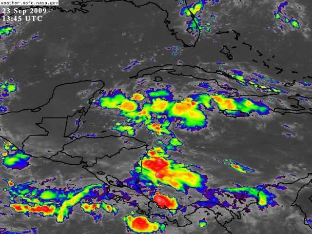
Re: Westeren Caribbean / SW Gulf Development??
Here's a better view of the area. Low pressures, for sure.

0 likes
-
frederic79
- Category 1
- Posts: 271
- Joined: Sun Jul 18, 2004 8:48 pm
- Location: Grand Bay, AL
Re: Westeren Caribbean / SW Gulf Development??
Pressures are indeed 1008-1009 mb range and SST's are ranging from 86-87 degrees in the Caymans. If shear were to relax this could get interesting.
0 likes
Re: Westeren Caribbean / SW Gulf Development??
Wow...it got me! Pressure rose 2.3MB in one hour and wind shifted to ESE. I would say outflow boundary, but the winds don't work out...
0 likes
-
wxman57
- Moderator-Pro Met
- Posts: 23176
- Age: 68
- Joined: Sat Jun 21, 2003 8:06 pm
- Location: Houston, TX (southwest)
Re: Westeren Caribbean / SW Gulf Development??
drezee wrote:Wow...it got me! Pressure rose 2.3MB in one hour and wind shifted to ESE. I would say outflow boundary, but the winds don't work out...
Yeah, buoy pressures rose in the last hour or two, but general pressures across the region are MUCH lower than in June-August. The "problem" back then was a stronger-than-normal Bermuda High and very strong low-level flow across the Caribbean. That's no longer an issue, it appears.
0 likes
Re: Westeren Caribbean / SW Gulf Development??
wxman57 wrote:drezee wrote:Wow...it got me! Pressure rose 2.3MB in one hour and wind shifted to ESE. I would say outflow boundary, but the winds don't work out...
Yeah, buoy pressures rose in the last hour or two, but general pressures across the region are MUCH lower than in June-August. The "problem" back then was a stronger-than-normal Bermuda High and very strong low-level flow across the Caribbean. That's no longer an issue, it appears.
Right, your GARP shows a potential for a broad area of low pressure. It needs to slow down before the Yucatan...weak system can develop over the Yucatan though...please, no one throw me under the bus, but I will go into my sat archive on Opal...seem to remember Opal looking a lot like this before it went onshore of the Yucatan...
0 likes
-
wxman57
- Moderator-Pro Met
- Posts: 23176
- Age: 68
- Joined: Sat Jun 21, 2003 8:06 pm
- Location: Houston, TX (southwest)
Re: Westeren Caribbean / SW Gulf Development??
drezee wrote:
Right, your GARP shows a potential for a broad area of low pressure. It needs to slow down before the Yucatan...weak system can develop over the Yucatan though...please, no one throw me under the bus, but I will go into my sat archive on Opal...seem to remember Opal looking a lot like this before it went onshore of the Yucatan...
That's precisely the type of development we need to watch for, given the general conditions across the tropics this year. Earlier, the Caribbean just killed everything that moved through it, so there was no chance of development in the BoC or SW Gulf. But if disturbances start making it into that region then we need to keep a close eye on the area.
0 likes
-
srainhoutx

- S2K Supporter

- Posts: 6919
- Age: 68
- Joined: Sun Jan 14, 2007 11:34 am
- Location: Haywood County, NC
- Contact:
Re: Westeren Caribbean / SW Gulf Development??
I mentioned last week in the Tropics Are Flat Dead Topic concerning the W Caribbean and SW GOM. Models have been 'sniffing' this area out for days, but most were more interested in "Fred". 
0 likes
-
IvanSurvivor
- Tropical Storm

- Posts: 152
- Joined: Wed Aug 20, 2008 12:12 am
- Location: Pensacola Florida (Warrington)
Re: Westeren Caribbean / SW Gulf Development??
Interesting looking over the models...12z NAM indicates a upper high over the GOM at 84 hours and a screaming outflow jet to the SE of the potential system...
http://www.nco.ncep.noaa.gov/pmb/nwprod ... 0_084l.gif
http://www.nco.ncep.noaa.gov/pmb/nwprod ... 0_084l.gif
0 likes
-
Dean4Storms
- S2K Supporter
- Posts: 6358
- Age: 63
- Joined: Sun Aug 31, 2003 1:01 pm
- Location: Miramar Bch. FL
-
Dean4Storms
- S2K Supporter
- Posts: 6358
- Age: 63
- Joined: Sun Aug 31, 2003 1:01 pm
- Location: Miramar Bch. FL
CMC 00z run does try to close off a low in the BOC and then seems to have it get caught up in the longwave trough next week over the central GOM.
http://moe.met.fsu.edu/cgi-bin/cmctc2.c ... =Animation
http://moe.met.fsu.edu/cgi-bin/cmctc2.c ... =Animation
0 likes
-
IvanSurvivor
- Tropical Storm
- Posts: 152
- Joined: Wed Aug 20, 2008 12:12 am
- Location: Pensacola Florida (Warrington)
Re: Westeren Caribbean / SW Gulf Development??
drezee wrote:Interesting looking over the models...12z NAM indicates a upper high over the GOM at 84 hours and a screaming outflow jet to the SE of the potential system...
http://www.nco.ncep.noaa.gov/pmb/nwprod ... 0_084l.gif
For those of us that don't know how to look at these maps, etc....can you give us a little more info as to what that means. Trying to learn as much as possible so that one day I don't have to ask so many dumb questions.
I know this is way too early since this is not anything yet, but with all of the elements combined, which way would this "potential area of concern" be moving...if it crossed the Yucatan and ended up in the BOC or SW Gulf...would it continue to move W, WSW or could it potentially get picked up by something and moved North towards the Gulf Coast?
0 likes
-
gatorcane

- S2K Supporter
- Posts: 23708
- Age: 48
- Joined: Sun Mar 13, 2005 3:54 pm
- Location: Boca Raton, FL
Re: Westeren Caribbean / SW Gulf Development??
Wxman I checked the board early this AM but saw no topic. I was surprised also but figured somebody would open it. I do think many people have completely written off this season even though we are about to enter the prime-time month for WCAR development.
Why hasn't the NHC coded this area yet? Ridge to the north probably means into the Yucatan I guess -- could be a possible WGOM threat down the road, who knows. But something to watch for sure.
Why hasn't the NHC coded this area yet? Ridge to the north probably means into the Yucatan I guess -- could be a possible WGOM threat down the road, who knows. But something to watch for sure.
Last edited by gatorcane on Wed Sep 23, 2009 11:11 am, edited 2 times in total.
0 likes

Re: Westeren Caribbean / SW Gulf Development??
Could be a favorability pulse. I think I see a slight mid-level twist west of Cayman. No red IR makes me think no storm, but anyone who has followed the tropics knows it can change without notice.
0 likes

Re: Westeren Caribbean / SW Gulf Development??
I can tell that things have changed on the Caribbean, Central America has received average rainfall during this second half of september, but during Jun-Aug period rainfall was below average. Also tradewinds have been normal on september, but on Jun-Aug they were enhanced, the air was dryer and the skies were clearer. I think that the chance for development on this area has increased and we may see one tropical depression or storm in this area on this last part of the season.
0 likes
Who is online
Users browsing this forum: Google Adsense [Bot], WaveBreaking and 253 guests