Surface Trough near Leewards
Moderator: S2k Moderators
Forum rules

The posts in this forum are NOT official forecasts and should not be used as such. They are just the opinion of the poster and may or may not be backed by sound meteorological data. They are NOT endorsed by any professional institution or STORM2K. For official information, please refer to products from the National Hurricane Center and National Weather Service.

Surface Trough near Leewards
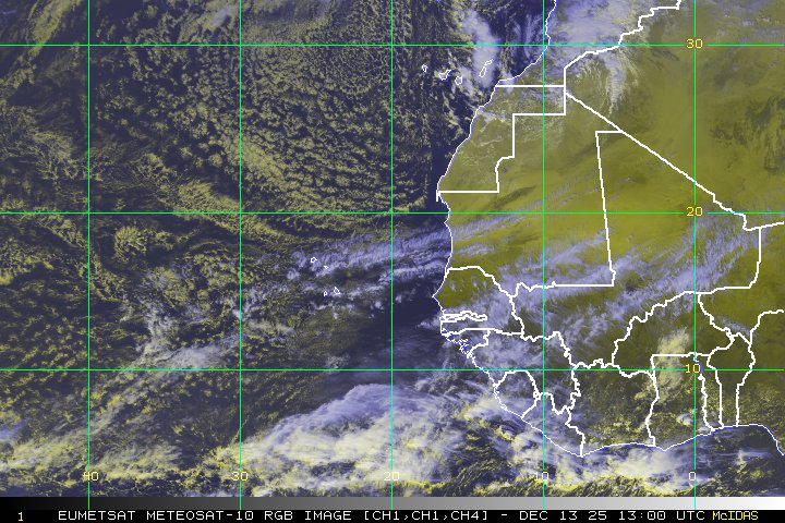
This wave is pretty far to the south, between 7 and 12 north. It has retained some convection, though not a great deal, and appears to have a spin at some level associated with it. It's getting late in the game for any east Atlantic system, but no reason that we can't keep a weather-eye on it. Shear looks low in its immediate future, and the air looks fairly moist until about 35 west.
0 likes


-
leanne_uk
- Tropical Storm

- Posts: 214
- Age: 43
- Joined: Fri Sep 04, 2009 4:38 pm
- Location: Loughborough countryside, Leicestershire, UK
thats the wave i looked at earlier and mentioned on TD 8 link. I dont know how to post images and sat feeds tho so couldnt put it on 
Anyways its on now and i am glad we can discuss it
Like the look of it tho esp with it being a bit further south than many of the systems of late
Anyways its on now and i am glad we can discuss it
Like the look of it tho esp with it being a bit further south than many of the systems of late
Last edited by leanne_uk on Fri Sep 25, 2009 6:46 pm, edited 1 time in total.
0 likes
-
ozonepete
- Professional-Met

- Posts: 4743
- Joined: Mon Sep 07, 2009 3:23 pm
- Location: From Ozone Park, NYC / Now in Brooklyn, NY
Re: New wave to south of Cape Verde Islands
I think this has some realistic TC potential. Can't post images right now, but TD8 will take the SAL with it and this easterly waver is farther south as you have both noted. Down side is the models don't acknowledge it at all, but they often don't at this early stage. It's size alone is a big plus. BTW, it's latitude is not far enough south to be a hindrance, from what I know.
0 likes
Re: New wave to south of Cape Verde Islands
I'm not sure if ridge/trough conditions are comparable, but maybe we'll have a Joyce 2000 redux type system. It formed around this time of year, and became a 90 mph hurricane, before upper level winds and the storm's own forward motion (if I remember correctly) severely weakened it. It piques my interest because Joyce and Isaac formed around the same time, while Isaac recurved and Joyce stayed south of 12-13 north for its life.
0 likes
-
ozonepete
- Professional-Met
- Posts: 4743
- Joined: Mon Sep 07, 2009 3:23 pm
- Location: From Ozone Park, NYC / Now in Brooklyn, NY
Re: New wave to south of Cape Verde Islands
Yeah, this one is pulling energy from TD8. It will be the dominant system.

Last edited by ozonepete on Fri Sep 25, 2009 9:11 pm, edited 1 time in total.
0 likes
-
Typhoon_Willie

- Category 5

- Posts: 1042
- Joined: Mon Jun 09, 2003 3:19 pm
- Location: Greenacres City, Florida
-
ozonepete
- Professional-Met
- Posts: 4743
- Joined: Mon Sep 07, 2009 3:23 pm
- Location: From Ozone Park, NYC / Now in Brooklyn, NY
Re:
Typhoon_Willie wrote:We will have to wait and see about that one.
I agree we just have to wait, but I think TD8 is taking the dust for it's follower... I added a satellite image to illustrate it, and we have to remember that at this time of year (end of September) the lower the latitude the African easterly wave is, the less likely it will get picked up by, or sheared by, the digging westerlies.
0 likes
-
ozonepete
- Professional-Met
- Posts: 4743
- Joined: Mon Sep 07, 2009 3:23 pm
- Location: From Ozone Park, NYC / Now in Brooklyn, NY
Re: New wave to south of Cape Verde Islands
Yeah, and actually, who the heck really knows which one of these, or neither, will develop into anything. I'm just leaning towards the second one at this point, but it's way too early to tell.
0 likes
Re: New wave to south of Cape Verde Islands
The wave actually looks sort of decent right now. It's got some convection back after poofing yesterday.
0 likes


-
ozonepete
- Professional-Met
- Posts: 4743
- Joined: Mon Sep 07, 2009 3:23 pm
- Location: From Ozone Park, NYC / Now in Brooklyn, NY
Re: New wave to south of Cape Verde Islands
Still keeping nice form for the location it's in. Can't post other images now, but the important factors - mid-level water vapor, upper winds and SSTs - look good down the road... I think the models will come on board soon.

0 likes
-
ozonepete
- Professional-Met
- Posts: 4743
- Joined: Mon Sep 07, 2009 3:23 pm
- Location: From Ozone Park, NYC / Now in Brooklyn, NY
Re: New wave to south of Cape Verde Islands
It still has potential. There's nothing definitive to tell us if might develop and/or strengthen yet, so let's keep watching.
0 likes
-
ozonepete
- Professional-Met
- Posts: 4743
- Joined: Mon Sep 07, 2009 3:23 pm
- Location: From Ozone Park, NYC / Now in Brooklyn, NY
Re: New wave to south of Cape Verde Islands
Still chuggin' along. Once it get's past the current high shear around 47 or 48W it will move into a low shear zone between 50 and 60W. Water vapor (especially the most important mid-level wv) improving markedly. SSTs obviously fine. Still worth following, IMHO.
0 likes

Re: New wave to south of Cape Verde Islands
A lot of convection near -47 W is that west of the wave axis? The mid level rotation is evident but I haven't looked at the low level flow for convergence.
edit: The first morning visibles showed a little rotation at the lower levels near 10.1 N -48W but the sheer is still evident.
edit: The first morning visibles showed a little rotation at the lower levels near 10.1 N -48W but the sheer is still evident.
0 likes
-
Gustywind

- Category 5
- Posts: 12334
- Joined: Mon Sep 03, 2007 7:29 am
- Location: Baie-Mahault, GUADELOUPE
000
AXNT20 KNHC 301059
TWDAT
TROPICAL WEATHER DISCUSSION
NWS TPC/NATIONAL HURRICANE CENTER MIAMI FL
805 AM EDT WED SEP 30 2009
TROPICAL WEATHER DISCUSSION FOR NORTH AMERICA...CENTRAL
AMERICA...GULF OF MEXICO...CARIBBEAN SEA...NORTHERN SECTIONS
OF SOUTH AMERICA...AND ATLANTIC OCEAN TO THE AFRICAN COAST
FROM THE EQUATOR TO 32N. THE FOLLOWING INFORMATION IS BASED
ON SATELLITE IMAGERY...METEOROLOGICAL ANALYSIS...WEATHER
OBSERVATIONS...AND RADAR.
BASED ON 0600 UTC SURFACE ANALYSIS AND SATELLITE IMAGERY
THROUGH 1015 UTC.
...TROPICAL WAVES...
AN ATLANTIC OCEAN TROPICAL WAVE IS ALONG 44W/45W TO THE SOUTH
OF 18N. STRONG SHOWERS AND THUNDERSTORMS ARE FROM 9N TO 13N
BETWEEN 45W AND 48W.
$$
MT
0 likes
Re: New wave to south of Cape Verde Islands
This wave that emerged from Africa with good curvature is now another 2009 ghost system east of the Lesser Antilles.
0 likes
Who is online
Users browsing this forum: Ulf and 207 guests