Posible Tropical Depression near Açores

This is the general tropical discussion area. Anyone can take their shot at predicting a storms path.

Moderator: S2k Moderators

Forum rules

The posts in this forum are NOT official forecasts and should not be used as such. They are just the opinion of the poster and may or may not be backed by sound meteorological data. They are NOT endorsed by any professional institution or STORM2K. For official information, please refer to products from the National Hurricane Center and National Weather Service.

Help Support Storm2K
Message
Author
pepeavilenho
Tropical Storm
Tropical Storm
Posts: 170
Joined: Thu Jul 09, 2009 12:01 pm

Posible Tropical Depression near Açores

#1 Postby pepeavilenho » Sun Jan 31, 2010 9:00 am

What do you think about this...

Image


Image

Image

Image

waiting for answers.... :cold:
0 likes   

User avatar
cycloneye
Admin
Admin
Posts: 139593
Age: 67
Joined: Thu Oct 10, 2002 10:54 am
Location: San Juan, Puerto Rico

Re: Posible Tropical Depression near Açores

#2 Postby cycloneye » Sun Jan 31, 2010 9:18 am

I moved the thread from Active Storms forum to Talking Tropics forum where it belongs.SST'S are running low in that area so I dont expect anything of a true warm core there.Neverless is interesting to see it.
0 likes   
Visit the Caribbean-Central America Weather Thread where you can find at first post web cams,radars
and observations from Caribbean basin members Click Here

pepeavilenho
Tropical Storm
Tropical Storm
Posts: 170
Joined: Thu Jul 09, 2009 12:01 pm

Re: Posible Tropical Depression near Açores

#3 Postby pepeavilenho » Sun Jan 31, 2010 9:26 am

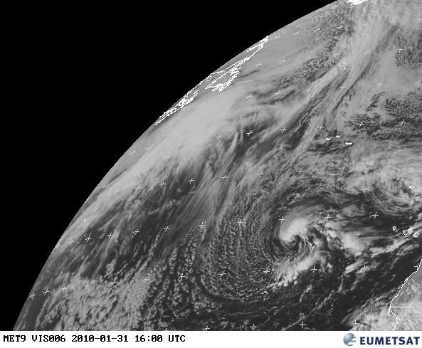
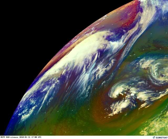
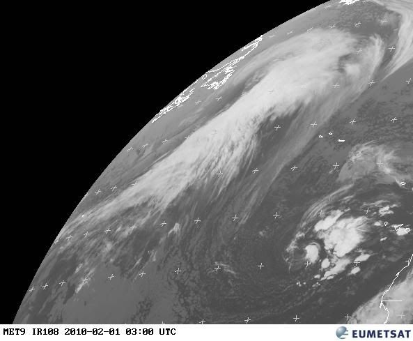
cycloneye wrote:I moved the thread from Active Storms forum to Talking Tropics forum where it belongs.SST'S are running low in that area so I dont expect anything of a true warm core there.Neverless is interesting to see it.


Im sorry about the wrong place of my post.

OK, we will see how is its development.

thanks, cycloneye :wink:
0 likes   

User avatar
Macrocane
Category 5
Category 5
Posts: 4218
Age: 35
Joined: Sun May 24, 2009 5:35 pm
Location: El Salvador

Re: Posible Tropical Depression near Açores

#4 Postby Macrocane » Sun Jan 31, 2010 12:16 pm

It looks like a subtropical low, if the center wasn't exposed it would look like a TD or Sub-TD, if we were on the hurricane season months maybe it would have a code yellow, it's an interesting system to watch kind of reminds me to last year's Grace but less organized.
0 likes   

User avatar
HURAKAN
Professional-Met
Professional-Met
Posts: 46086
Age: 37
Joined: Thu May 20, 2004 4:34 pm
Location: Key West, FL
Contact:

#5 Postby HURAKAN » Sun Jan 31, 2010 12:28 pm

Image

Image

I think it has no chance
0 likes   

User avatar
HURAKAN
Professional-Met
Professional-Met
Posts: 46086
Age: 37
Joined: Thu May 20, 2004 4:34 pm
Location: Key West, FL
Contact:

#6 Postby HURAKAN » Sun Jan 31, 2010 12:30 pm

705 AM TWD: http://www.nhc.noaa.gov/text/refresh/MI ... 1116.shtml?

A 996
MB GALE LOW IS CENTERED OVER THE E ATLANTIC NEAR 29N30W. AN
OCCLUDED FRONT IS N OF THE LOW CENTER ALONG 30N34W 33N30W
31N26W. A COLD FRONT CONTINUES S TO 24N27W 21N30W. SCATTERED
MODERATE CONVECTION IS E OF THE LOW CENTER FROM 28N-30N BETWEEN
28W-30W...AND E OF THE COLD FRONT FROM 25N-30N BETWEEN 24W-26W.
SCATTERED SHOWERS ARE ALSO WITHIN 45 NM OF THE REMAINDER OF THE
FRONTS. RESIDUAL WIDELY SCATTERED MODERATE CONVECTION FROM A
DISSIPATED COLD FRONT IS FURTHER E...NW OF THE CANARY ISLANDS
FROM 29N-35N BETWEEN 13W-22W.
0 likes   

RL3AO
Moderator-Pro Met
Moderator-Pro Met
Posts: 16308
Joined: Thu Jun 14, 2007 10:03 pm
Location: NC

#7 Postby RL3AO » Sun Jan 31, 2010 12:47 pm

It would need an eyewall before the NHC even thought about it this time of year. :lol:
0 likes   

User avatar
cycloneye
Admin
Admin
Posts: 139593
Age: 67
Joined: Thu Oct 10, 2002 10:54 am
Location: San Juan, Puerto Rico

Re: Posible Tropical Depression near Açores

#8 Postby cycloneye » Sun Jan 31, 2010 1:02 pm

If NHC was interested,it would be already a invest.
0 likes   
Visit the Caribbean-Central America Weather Thread where you can find at first post web cams,radars
and observations from Caribbean basin members Click Here

User avatar
cycloneye
Admin
Admin
Posts: 139593
Age: 67
Joined: Thu Oct 10, 2002 10:54 am
Location: San Juan, Puerto Rico

Re: Posible Tropical Depression near Açores

#9 Postby cycloneye » Sun Jan 31, 2010 2:47 pm

0 likes   
Visit the Caribbean-Central America Weather Thread where you can find at first post web cams,radars
and observations from Caribbean basin members Click Here

pepeavilenho
Tropical Storm
Tropical Storm
Posts: 170
Joined: Thu Jul 09, 2009 12:01 pm

#10 Postby pepeavilenho » Sun Jan 31, 2010 3:05 pm

mmmm....

Image

Image

nhc is :?:
0 likes   

User avatar
Category 5
Category 5
Category 5
Posts: 10074
Age: 34
Joined: Sun Feb 11, 2007 10:00 pm
Location: New Brunswick, NJ
Contact:

Re: Posible Tropical Depression near Açores

#11 Postby Category 5 » Sun Jan 31, 2010 3:23 pm

Wont become anything but thats impressive for this time of year.
0 likes   

Derek Ortt

#12 Postby Derek Ortt » Sun Jan 31, 2010 3:56 pm

looks like a small front extending to the SE of the system
0 likes   

CrazyC83
Professional-Met
Professional-Met
Posts: 33398
Joined: Tue Mar 07, 2006 11:57 pm
Location: Deep South, for the first time!

#13 Postby CrazyC83 » Sun Jan 31, 2010 10:14 pm

(Sub)Tropical Storm Alex in the making? Doubtful.
0 likes   

User avatar
Aslkahuna
Professional-Met
Professional-Met
Posts: 4550
Joined: Thu Feb 06, 2003 5:00 pm
Location: Tucson, AZ
Contact:

Re: Posible Tropical Depression near Açores

#14 Postby Aslkahuna » Sun Jan 31, 2010 10:30 pm

With all that cold air Cu in the western semicircle, it looks more like a typical Azores cutoff to me. I could probably dredge up similar looking examples from off the SoCA coast during El Niño years.

Steve
0 likes   

User avatar
HURAKAN
Professional-Met
Professional-Met
Posts: 46086
Age: 37
Joined: Thu May 20, 2004 4:34 pm
Location: Key West, FL
Contact:

#15 Postby HURAKAN » Sun Jan 31, 2010 11:18 pm

Image

No Alex here, but wait a few more months!!
0 likes   

User avatar
littlevince
S2K Supporter
S2K Supporter
Posts: 768
Joined: Fri Oct 21, 2005 10:45 am
Location: Portugal

Re: Posible Tropical Depression near Açores

#16 Postby littlevince » Mon Feb 01, 2010 8:16 am

0 likes   

User avatar
HURAKAN
Professional-Met
Professional-Met
Posts: 46086
Age: 37
Joined: Thu May 20, 2004 4:34 pm
Location: Key West, FL
Contact:

#17 Postby HURAKAN » Mon Feb 01, 2010 9:32 am

Image

Looking good but I don't think it's tropical or subtropical
0 likes   

User avatar
HURAKAN
Professional-Met
Professional-Met
Posts: 46086
Age: 37
Joined: Thu May 20, 2004 4:34 pm
Location: Key West, FL
Contact:

#18 Postby HURAKAN » Mon Feb 01, 2010 9:33 am

TWD 705 AM: http://www.nhc.noaa.gov/text/refresh/MI ... 1116.shtml?

A 1002 MB LOW IS
CENTERED OVER THE E ATLANTIC NEAR 27N23W. AN OCCLUDED FRONT IS N
OF THE LOW CENTER ALONG 31N24W 33N17W 31N14W. A COLD FRONT
CONTINUES S TO 27N15W 19N24W. CLUSTERS OF SCATTERED MODERATE
CONVECTION ARE IN VICINITY OF THE LOW CENTER FROM 25N-30N
BETWEEN 18W-25W. SCATTERED SHOWERS ARE ALSO WITHIN 45 NM OF THE
REMAINDER OF THE FRONTS.
0 likes   

User avatar
HURAKAN
Professional-Met
Professional-Met
Posts: 46086
Age: 37
Joined: Thu May 20, 2004 4:34 pm
Location: Key West, FL
Contact:

#19 Postby HURAKAN » Mon Feb 01, 2010 9:43 am

SHIP S 1200 24.30 -24.90 192 213 290 32.1 - 26.2 5.0 - - 29.71 +0.12 71.6 69.8 66.2 5

This cannot be right, SST at almost 70°F that far north?
0 likes   

User avatar
HURAKAN
Professional-Met
Professional-Met
Posts: 46086
Age: 37
Joined: Thu May 20, 2004 4:34 pm
Location: Key West, FL
Contact:

#20 Postby HURAKAN » Mon Feb 01, 2010 9:45 am

Image

Image

Interesting anomalies
0 likes   


Return to “Talkin' Tropics”

Who is online

Users browsing this forum: kevin and 55 guests