Tropical wave in Eastern Caribbean

This is the general tropical discussion area. Anyone can take their shot at predicting a storms path.

Moderator: S2k Moderators

Forum rules

The posts in this forum are NOT official forecasts and should not be used as such. They are just the opinion of the poster and may or may not be backed by sound meteorological data. They are NOT endorsed by any professional institution or STORM2K. For official information, please refer to products from the National Hurricane Center and National Weather Service.

Help Support Storm2K
Message
Author
Weatherfreak000

Tropical wave in Eastern Caribbean

#1 Postby Weatherfreak000 » Wed Jun 30, 2010 8:54 pm

TROPICAL WAVE IS ALONG 30W TO THE SOUTH OF 15N...MOVING WESTWARD
10-15 KT. THIS WAVE IS EMBEDDED IN AN AREA OF ELEVATED VALUES OF
MOISTURE AS DEPICTED ON TOTAL PRECIPITABLE WATER IMAGERY. LOW
LEVEL WEAK CYCLONIC CURVATURE IS OBSERVED ON THE NORTHERN HALF
OF THE WAVE AXIS. WAVE ALSO LINES UP WELL WITH MODEL POTENTIAL
VORTICITY ANALYSIS. SHOWERS AND THUNDERSTORMS ARE FROM 3N TO 11N
BETWEEN 26W AND 34W.


Image

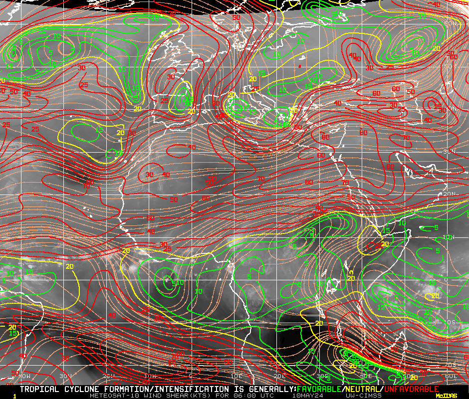
Wind shear pattern is moderately conducive as well. Looking nice tonight. It appears the wave we were viewing that apparently dissipated may be flaring up again.
0 likes   

User avatar
BigA
Professional-Met
Professional-Met
Posts: 1317
Joined: Sun Jul 24, 2005 10:56 pm

Re: Tropical Wave at 30W

#2 Postby BigA » Wed Jun 30, 2010 9:04 pm

I think the CMC and NOGAPS kinda sorta develop this one, but I need more and better models before I latch on. Still, in July things can start forming east of the islands.
0 likes   

Weatherfreak000

#3 Postby Weatherfreak000 » Wed Jun 30, 2010 9:14 pm

They discussed that in the TWD.

Shear appears marginally favorable at least.
0 likes   

User avatar
HURAKAN
Professional-Met
Professional-Met
Posts: 46086
Age: 38
Joined: Thu May 20, 2004 4:34 pm
Location: Key West, FL
Contact:

#4 Postby HURAKAN » Wed Jun 30, 2010 9:23 pm

The search for Bonnie begins!!
0 likes   

Weatherfreak000

Re: Tropical Wave at 30W

#5 Postby Weatherfreak000 » Wed Jun 30, 2010 10:45 pm

Image


Vorticity is easy to spot in this loop as it made it's way past the SAL Zone, the wave (My prediction for Future-94L) has flared up considerably tonight. The wave behind it still in Africa is large, and should do well to hold back the SAL from halting

Image

SAL is being disrupted by large amounts of moisture all around this wave, as well as infront and inback of the system. You just can't script a better scenario for cyclogenesis. Lower and Upper Level Divergence are both favorable.


Edit: When a system is looking this good you tend to want to look into it's environment ahead of it. Wind shear drops off significantly when it makes it to 40W. We may see an invest from this area soon.
0 likes   

User avatar
BigA
Professional-Met
Professional-Met
Posts: 1317
Joined: Sun Jul 24, 2005 10:56 pm

Re: Tropical Wave at 30W

#6 Postby BigA » Wed Jun 30, 2010 11:33 pm

Weatherfreak000 wrote:
Vorticity is easy to spot in this loop as it made it's way past the SAL Zone, the wave (My prediction for Future-94L) has flared up considerably tonight. The wave behind it still in Africa is large, and should do well to hold back the SAL from halting


SAL is being disrupted by large amounts of moisture all around this wave, as well as infront and inback of the system. You just can't script a better scenario for cyclogenesis. Lower and Upper Level Divergence are both favorable.


Edit: When a system is looking this good you tend to want to look into it's environment ahead of it. Wind shear drops off significantly when it makes it to 40W. We may see an invest from this area soon.


Solid and well-evidenced analysis, especially the part about how the wave behind this one would protect it (From what I remember, with SAL, the wave behind protects the wave ahead). I think it would be designated 95L if it became an invest; if I recall, we had a short-lived 94L.
0 likes   

User avatar
HURAKAN
Professional-Met
Professional-Met
Posts: 46086
Age: 38
Joined: Thu May 20, 2004 4:34 pm
Location: Key West, FL
Contact:

#7 Postby HURAKAN » Wed Jun 30, 2010 11:35 pm

Image

A high pressure system seems to be over or near this system
0 likes   

Hugo1989
Tropical Storm
Tropical Storm
Posts: 147
Joined: Mon Jun 14, 2010 9:09 am

Re: Tropical Wave at 30W

#8 Postby Hugo1989 » Wed Jun 30, 2010 11:50 pm

Where is bonnie?
0 likes   

Hugo1989
Tropical Storm
Tropical Storm
Posts: 147
Joined: Mon Jun 14, 2010 9:09 am

#9 Postby Hugo1989 » Wed Jun 30, 2010 11:52 pm

Whom is the next invest?
0 likes   

User avatar
HURAKAN
Professional-Met
Professional-Met
Posts: 46086
Age: 38
Joined: Thu May 20, 2004 4:34 pm
Location: Key West, FL
Contact:

Re: Tropical Wave at 30W

#10 Postby HURAKAN » Wed Jun 30, 2010 11:57 pm

Hugo1989 wrote:Where is bonnie?


It hasn't formed yet but that's the next name
0 likes   

User avatar
HURAKAN
Professional-Met
Professional-Met
Posts: 46086
Age: 38
Joined: Thu May 20, 2004 4:34 pm
Location: Key West, FL
Contact:

Re:

#11 Postby HURAKAN » Wed Jun 30, 2010 11:58 pm

Hugo1989 wrote:Whom is the next invest?


95L
0 likes   

Hugo1989
Tropical Storm
Tropical Storm
Posts: 147
Joined: Mon Jun 14, 2010 9:09 am

Re: Tropical Wave at 30W

#12 Postby Hugo1989 » Thu Jul 01, 2010 12:05 am

HURAKAN wrote:
Hugo1989 wrote:Where is bonnie?


It hasn't formed yet but that's the next name


jajaja yes i know!
I said by the wave that goes through the 35w and other wave out of africa
0 likes   

User avatar
cycloneye
Admin
Admin
Posts: 145531
Age: 68
Joined: Thu Oct 10, 2002 10:54 am
Location: San Juan, Puerto Rico

Re: Tropical Wave at 30W

#13 Postby cycloneye » Thu Jul 01, 2010 5:43 am

Well,CMC develops this wave,but is only one model as a consensus is needed.

http://moe.met.fsu.edu/cgi-bin/cmctc2.c ... =Animation
0 likes   
Visit the Caribbean-Central America Weather Thread where you can find at first post web cams,radars
and observations from Caribbean basin members Click Here

Weatherfreak000

Re: Tropical Wave in Eastern Atlantic

#14 Postby Weatherfreak000 » Thu Jul 01, 2010 11:24 am

The hunt for 95L is indeed on. Allow me to show yall model runs!


The CMC develops this and send it north of the Lesser Antilles islands.....it seems fish may be what becomes of this wave.


HOWEVER, the GFDL is spotting a T.S. like low developing in 4 1/2 says on the East side of the Florida Peninsula.

Image


GFS now onboard with Bob Breck's VIPIR Model as well as past runs of HWRF and GFDL (Considerable Model Agreement) for a Low developing in the GOM in the 2-3 day time frame.

Image

The GFS and HWRF (HWRF being weaker) is ALSO showing the Florida East Coast style development along with GFDL in the 4 1/2 day time frame.


NOGAPS sees a Caribbean development at the end of its run. The race is on everyone we have our players/
0 likes   

Weatherfreak000

Re: Tropical Wave in Eastern Atlantic

#15 Postby Weatherfreak000 » Thu Jul 01, 2010 11:31 am

Here's your latest vorticity map.

Image


The wave emerging off 60 W is looking VERY impressive, unfortunately shear is brutal in that area. That wave may have to sacrifice it's energy to the wave I am seeing at 40W.
0 likes   

Weatherfreak000

Re: Tropical Wave in Eastern Atlantic

#16 Postby Weatherfreak000 » Thu Jul 01, 2010 2:22 pm

EURO develops in GOM
0 likes   

User avatar
Fego
S2K Supporter
S2K Supporter
Posts: 767
Age: 65
Joined: Sun Apr 18, 2004 7:58 pm
Location: San Juan, Puerto Rico
Contact:

Re: Tropical Wave in Eastern Atlantic

#17 Postby Fego » Thu Jul 01, 2010 2:31 pm

Image

Uploaded with ImageShack.us

Got some purple? color.
0 likes   
Go Giants! Go Niners! Go Warriors!

Frank2
Category 5
Category 5
Posts: 4061
Joined: Mon Jul 25, 2005 12:47 pm

Re: Tropical Wave in Eastern Atlantic

#18 Postby Frank2 » Thu Jul 01, 2010 2:42 pm

That chart reminds me of the album Less than Zero...

LOL
0 likes   

User avatar
cycloneye
Admin
Admin
Posts: 145531
Age: 68
Joined: Thu Oct 10, 2002 10:54 am
Location: San Juan, Puerto Rico

Re: Tropical Wave in Eastern Atlantic

#19 Postby cycloneye » Thu Jul 01, 2010 2:46 pm

Weatherfreak000 wrote:EURO develops in GOM


12z EURO Loop

Image
0 likes   
Visit the Caribbean-Central America Weather Thread where you can find at first post web cams,radars
and observations from Caribbean basin members Click Here

Flyinman
S2K Supporter
S2K Supporter
Posts: 265
Joined: Thu Aug 16, 2007 3:03 pm
Location: The Woodlands, Texas

Re: Tropical Wave in Eastern Atlantic

#20 Postby Flyinman » Thu Jul 01, 2010 2:58 pm

Wow, hope the Euro is not correct this time. I do not care to see the first 2 storms of of the season in the Gulf. The last time we had several storms in the Gulf, our finale was Ike!
0 likes   


Return to “Talkin' Tropics”

Who is online

Users browsing this forum: Google Adsense [Bot], TheBurn, weatherSnoop and 30 guests