To help us through this lull before August, let's discuss the unusual and the impressive. Any storm that just baffles the mind, either because of pure raw power, or pure meteorological oddity, gets discussed here. I know threads like this have existed in the past, but there's no point in bumping a year old thread. We were discussing it in the chat, and figured a new thread would be worth making.
Start off with something small, Erika, 2003.
http://en.wikipedia.org/wiki/File:Erika_2003_track.png
Born near the Azores, and hit northern Mexico. I'm fairly sure that's never happened before.
Unusual, Impressive, and Interesting Storms
Moderator: S2k Moderators
Forum rules

The posts in this forum are NOT official forecasts and should not be used as such. They are just the opinion of the poster and may or may not be backed by sound meteorological data. They are NOT endorsed by any professional institution or STORM2K. For official information, please refer to products from the National Hurricane Center and National Weather Service.
Unusual, Impressive, and Interesting Storms
Last edited by Cyclone1 on Sat Jul 17, 2010 10:06 pm, edited 1 time in total.
0 likes
-
Florida1118
-
Blown Away

- S2K Supporter

- Posts: 10253
- Joined: Wed May 26, 2004 6:17 am
Re: Unusual, Impressive, and Interesting Storms
Frances & Jeanne landfalled in Florida a few weeks apart, both on a Saturday evening, almost within the same hour, and the landfall point was essentially the same point, about 2 miles apart. What were the odds of that happening!
0 likes
Hurricane Eye Experience: David 79, Irene 99, Frances 04, Jeanne 04, Wilma 05… Hurricane Brush Experience: Andrew 92, Erin 95, Floyd 99, Matthew 16, Irma 17, Ian 22, Nicole 22…

Re: Unusual, Impressive, and Interesting Storms
I think it was not confirmed but it is supposed that Hurricane Hattie (1961), Tropical storm Simone and tropical storm Inga were the same system or at least Hattie helped to the formation of Simone and Simone helped to formation of Inga, you can see the tracks here:


0 likes
-
cycloneye

- Admin

- Posts: 149761
- Age: 69
- Joined: Thu Oct 10, 2002 10:54 am
- Location: San Juan, Puerto Rico
Re: Unusual, Impressive, and Interesting Storms
This is a great thread. I am sure,anyone will not forget the crazy Lenny of November 1999.

0 likes
Visit the Caribbean-Central America Weather Thread where you can find at first post web cams,radars
and observations from Caribbean basin members Click Here
and observations from Caribbean basin members Click Here
-
HURAKAN

- Professional-Met

- Posts: 46084
- Age: 39
- Joined: Thu May 20, 2004 4:34 pm
- Location: Key West, FL
- Contact:
Re: Unusual, Impressive, and Interesting Storms
TROPICAL STORM GRACE (2009)
HURRICANE VINCE (2005)

HURRICANE VINCE (2005)
0 likes
-
Florida1118


-
Aslkahuna

- Professional-Met
- Posts: 4549
- Joined: Thu Feb 06, 2003 5:00 pm
- Location: Tucson, AZ
- Contact:
Re: Unusual, Impressive, and Interesting Storms
Many years ago (and I do mean many) Weatherwise had an article about the Hattie-Simone-Inga Trifecta (in 1961 EPAC storms were forecast by the SFO USWB Office). Today, that would not happen since Hattie made it over to EPAC fairly intact with an identifiable low pressure center. John in 1994 was, until Ioke, the strongest storm on record in CPAC during his first trip through. The storm is still the longest lasting on record beating out Ginger in the ATL.
Steve
Steve
0 likes

Ginger had a pretty cool track, it looked like it was going to escape out to sea but a very powerful upper high must have blocked the systems exit route and it ended up backing in on itself and doing a 180 flip!
0 likes
Personal Forecast Disclaimer:
The posts in this forum are NOT official forecast and should not be used as such. They are just the opinion of the poster and may or may not be backed by sound meteorological data. They are NOT endorsed by any professional institution or storm2k.org. For official information, please refer to the NHC and NWS products
The posts in this forum are NOT official forecast and should not be used as such. They are just the opinion of the poster and may or may not be backed by sound meteorological data. They are NOT endorsed by any professional institution or storm2k.org. For official information, please refer to the NHC and NWS products
-
littlevince

- S2K Supporter
- Posts: 768
- Joined: Fri Oct 21, 2005 10:45 am
- Location: Portugal
Re: Unusual, Impressive, and Interesting Storms
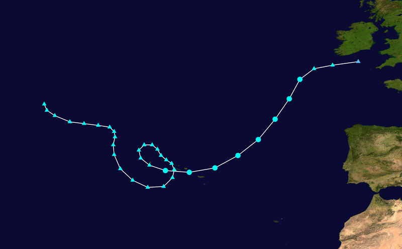
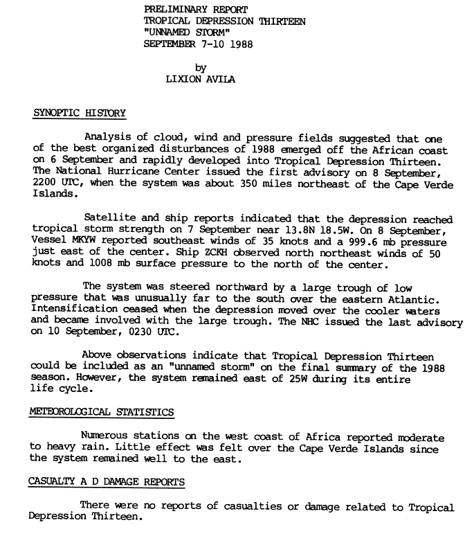
1988 Unnamed Tropical Storm
http://www.nhc.noaa.gov/archive/storm_w ... elim01.gif

Loop (7-9 September 1988)

http://www.nhc.noaa.gov/archive/storm_w ... elim01.gif
Loop (7-9 September 1988)

0 likes
You can see just how deep the ULL/trough digs there on that image, it really does lift the system right out. Looks to me like it gets enhanced by the ULL as it goes up the eastern side of the ULL.
0 likes
Personal Forecast Disclaimer:
The posts in this forum are NOT official forecast and should not be used as such. They are just the opinion of the poster and may or may not be backed by sound meteorological data. They are NOT endorsed by any professional institution or storm2k.org. For official information, please refer to the NHC and NWS products
The posts in this forum are NOT official forecast and should not be used as such. They are just the opinion of the poster and may or may not be backed by sound meteorological data. They are NOT endorsed by any professional institution or storm2k.org. For official information, please refer to the NHC and NWS products
-
Ivanhater

- Storm2k Moderator

- Posts: 11222
- Age: 39
- Joined: Fri Jul 01, 2005 8:25 am
- Location: Pensacola
Re: Unusual, Impressive, and Interesting Storms
For me personally was sitting on the back porch with no power in a disaster zone in Pensacola after Ivan. Listening to the radio and hearing Ivan was back in the gulf coming for more...insane
0 likes
Michael
-
littlevince
- S2K Supporter
- Posts: 768
- Joined: Fri Oct 21, 2005 10:45 am
- Location: Portugal
Re:
Cyclone1 wrote:Where'd you get that gif, or did you make it?
Yes, I made it with images from gibbs
If you liked, I have Erika from 2003 you mentioned the 1st post, in youtube videoformat, because Gif is too big
Select HD 720p and fullscreen for better quality:
http://www.youtube.com/watch?v=MqY_B6FolxU
0 likes
Re: Re:
littlevince wrote:Cyclone1 wrote:Where'd you get that gif, or did you make it?
Yes, I made it with images from gibbs
If you liked, I have Erika from 2003 you mentioned the 1st post, in youtube videoformat, because Gif is too big
Select HD 720p and fullscreen for better quality:
http://www.youtube.com/watch?v=MqY_B6FolxU
Oooooh, that is so awesome! How easy are these to make? (And how many do you have?)
0 likes
-
LSU2001

- S2K Supporter
- Posts: 1711
- Age: 58
- Joined: Sat Sep 11, 2004 11:01 pm
- Location: Cut Off, Louisiana
Re: Unusual, Impressive, and Interesting Storms
TS Erin 2007 has to be the weirdest storm I have ever watched. She looked like a hurricane over Oklahoma.

Tim
During the last Atlantic hurricane season, our "E" storm was Erin. It occurred in mid-August.
But only now, in April, has the corresponding National Hurricane Center tropical cyclone report (PDF) finally been released. The extraordinarily long time gap underscores just how mysterious a meteorological phenomenon Erin actually was, and how long it must have taken meteorologists to figure out what they could say about it.
Consider: Over water, Erin was never anything but a weak and disorganized tropical storm, one that struck the Texas coast on August 16 with maximum sustained winds of 30 knots (tropical depression class).
But then something beyond crazy happened.
Over land, the remnants of the storm system looped up towards Oklahoma and reorganized, so much so that August 19 satellite images show Erin, its center very close to Oklahoma City, resembling an overland hurricane with an "eye" that it had never managed to develop over water. Meanwhile, the winds picked up far more than they ever had over the Gulf – reaching 50 knots sustained, 70 knot gusts – even as pressure fell as far as 995 millibars (far lower than when Erin had been an easily categorizable tropical storm).
So what on earth was Erin after it re-intensified over land?
Debate about this among hurricane specialists appears to be the reason the official report on Erin took so long to come out. The answer is that the experts don't know what to call it – none of the familiar categories work. As the report explains:
Read more: http://www.thedailygreen.com/environmen ... z0u4U8ngID
0 likes
Personal Forecast Disclaimer:
The posts in this forum are NOT official forecast and should not be used as such. They are NOT endorsed by any professional institution or storm2k.org. For official information, please refer to the NHC and NWS products.
The posts in this forum are NOT official forecast and should not be used as such. They are NOT endorsed by any professional institution or storm2k.org. For official information, please refer to the NHC and NWS products.
-
Hurricanehink

- S2K Supporter
- Posts: 2046
- Joined: Sun Nov 16, 2003 2:05 pm
- Location: New Jersey
Re: Unusual, Impressive, and Interesting Storms
I think it goes without saying, but the 1991 Halloween Nor'easter (the Perfect Storm) is certainly unusual and interesting. It formed from a huge non-tropical low off the coast of Nova Scotia, moved over the Gulf Stream east of New Jersey, developed a small area of convection, and a small hurricane developed inside the huge storm.

Track

Image while becoming subtropical

At peak intensity
Track
Image while becoming subtropical
At peak intensity
0 likes
-
HurricaneBill
- Category 5

- Posts: 3419
- Joined: Sun Apr 11, 2004 5:51 pm
- Location: East Longmeadow, MA, USA
Re: Unusual, Impressive, and Interesting Storms
This storm in 1867. Imagine if a storm took a track like this now:

The Yankee Hurricane of 1935:

Probably the most bizarre track in the WPAC: Typhoon Wayne 1986
[youtube]http://www.youtube.com/watch?v=UlTz2rAmFwc[/youtube]
The Yankee Hurricane of 1935:
Probably the most bizarre track in the WPAC: Typhoon Wayne 1986
[youtube]http://www.youtube.com/watch?v=UlTz2rAmFwc[/youtube]
0 likes
Re: Unusual, Impressive, and Interesting Storms
0 likes
Who is online
Users browsing this forum: Google Adsense [Bot] and 158 guests