2011 Tropical Waves

This is the general tropical discussion area. Anyone can take their shot at predicting a storms path.

Moderator: S2k Moderators

Forum rules

The posts in this forum are NOT official forecasts and should not be used as such. They are just the opinion of the poster and may or may not be backed by sound meteorological data. They are NOT endorsed by any professional institution or STORM2K. For official information, please refer to products from the National Hurricane Center and National Weather Service.

Help Support Storm2K
Message
Author
RL3AO
Moderator-Pro Met
Moderator-Pro Met
Posts: 16308
Joined: Thu Jun 14, 2007 10:03 pm
Location: NC

2011 Tropical Waves

#1 Postby RL3AO » Mon May 16, 2011 1:00 pm

I know PK does this on a UK forum. Why not have one on the great storm2k?

Note: For identification time, I'll use the first time its mentioned in the Tropical Weather Discussion, not when it shows up on the surface analysis. Also, click to enlarge the satellite images.
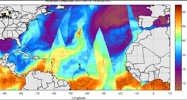
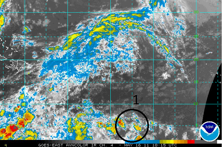
Tropical Wave #1
* Identified May 15 1400 EDT at 7N38W TO 2N42W
* Removed May 22 0800 EDT at 71W near Venezuela
* Related threads - Pre-Invest
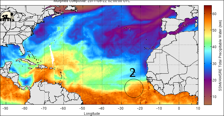
Image Image

Tropical Wave #2
* Identified May 22 0200 EDT ALONG 23W TO THE SOUTH OF 7N
* Removed May 22 1400 EDT ALONG 23W/24W
Image Image

Tropical Wave #3
* Identified May 26 1400 EDT ALONG 11N53W 8N54W 5N54W
* Removed May 30 1400 EDT 72W/73W S OF 13N
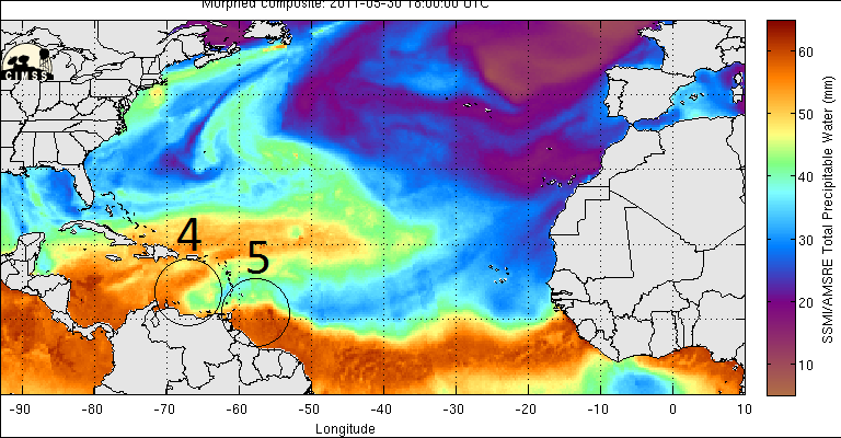
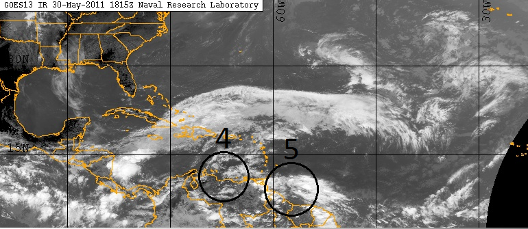
Image Image


Tropical Wave #4
* Identified May 26 2000 EDT FROM 01N46W TO 08N43W
* Removed June 02 0200 EDT ALONG 79W TO THE SOUTH OF 17N
Image Image

Tropical Wave #5
* Identified May 30 2000 EDT ALONG 59W S OF 12N
* Removed June 02 2000 EDT ALONG 78W S OF E CUBA TO E PANAMA
Image Image

Tropical Wave #6
* Identified May 31 1400 EDT ALONG 33W TO THE SOUTH OF
10N
* Removed June 05 1400 EDTALONG 62W/63W HAS MOVED NW AND MERGED WITH A SURFACE TROUGH N OF THE LEEWARD ISLANDS
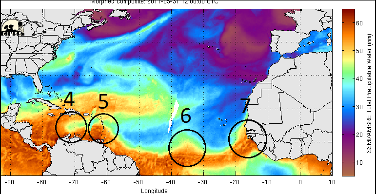
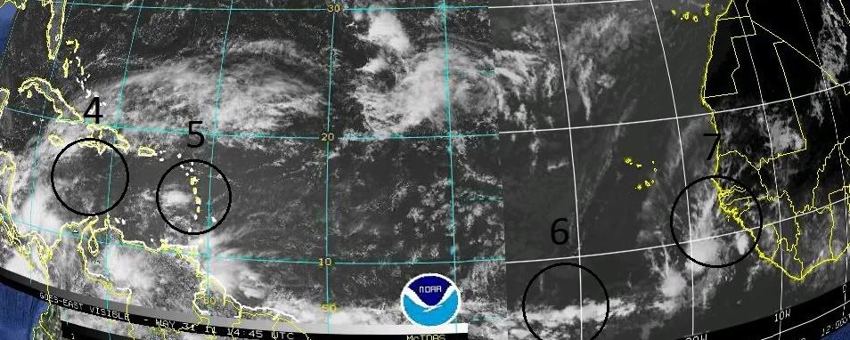
Image Image

Tropical Wave #7
* Identified May 31 1400 EDT ALONG 16W/17W TO THE SOUTH
OF 17N
* Removed June 08 1400 EDT ALONG 16N59W INTO
NORTHEASTERN VENEZUELA
Image Image

Tropical Wave #8
* Identified June 04 2000 EDT FROM 11N32W TO 6N30W
* Removed June 07 1400 EDTALONG 11N51W TO NORTHEASTERN FRENCH GUIANA NEAR 5N53W
* Re-identified June 12 0800 EDTALONG 80W S OF 12N MOVING W AT 10 KT
* Removed June 14 0400 UTC ALONG 90W/91W
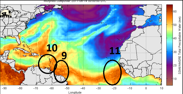
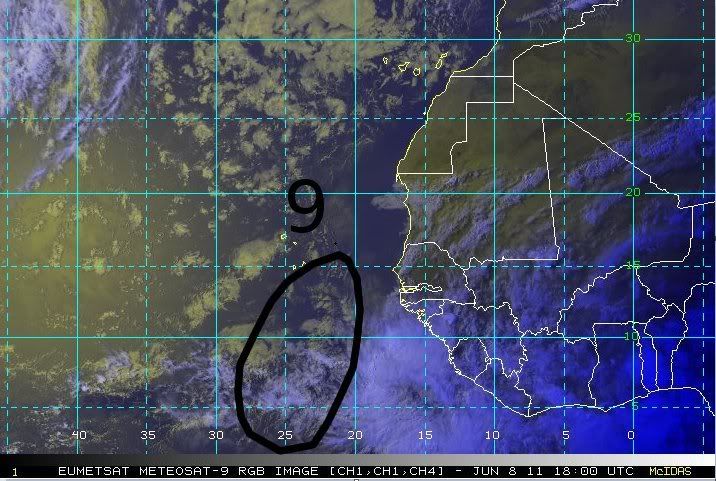
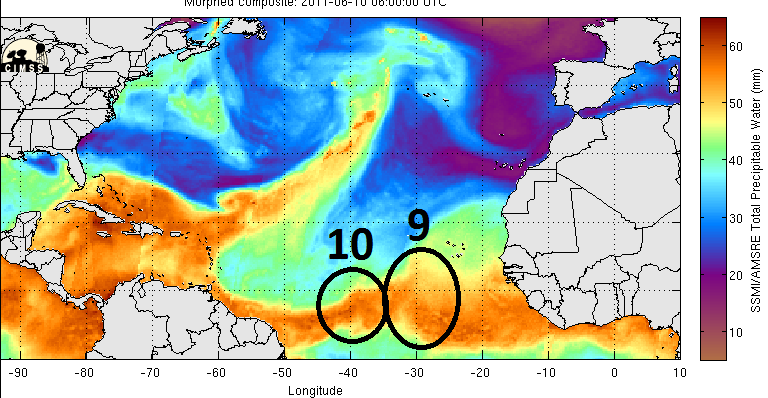
Image Image

Tropical Wave #9
* Identified June 08 2000 EDT FROM 16N22W TO 6N28W
Image Image

Tropical Wave #10
* Identified June 10 0800 EDT ALONG 13N39W 8N42W 4N44W
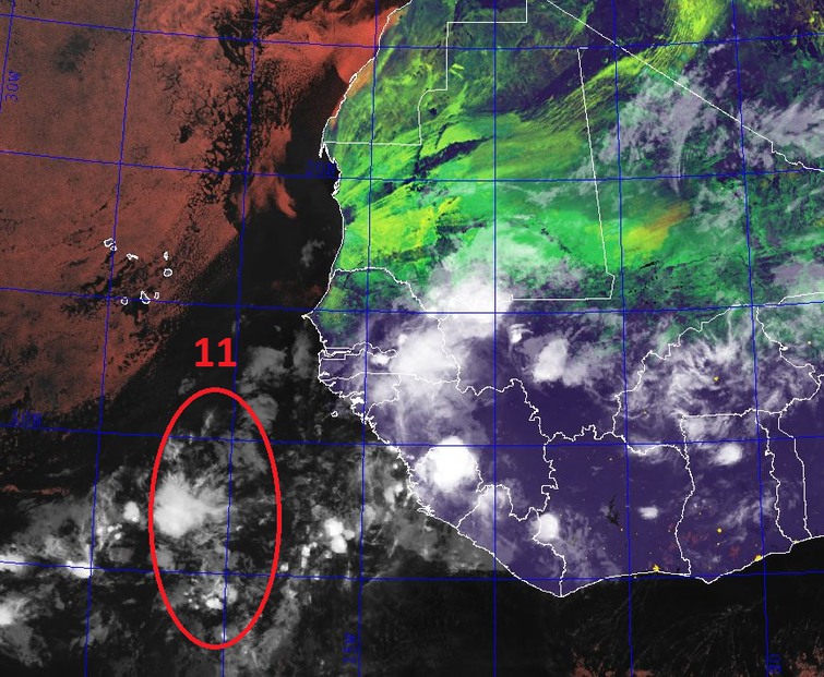
Image Image

Tropical Wave #11
* Identified June 14 0200 EDT FROM 14N20W TO 3N23W
Image Image Image
Last edited by RL3AO on Wed Jun 15, 2011 1:52 pm, edited 26 times in total.
0 likes   

User avatar
wxman57
Moderator-Pro Met
Moderator-Pro Met
Posts: 22980
Age: 67
Joined: Sat Jun 21, 2003 8:06 pm
Location: Houston, TX (southwest)

Re: 2011 Tropical Waves

#2 Postby wxman57 » Mon May 16, 2011 1:16 pm

Instead of using satellite imagery, I suggest TPW imagery as available here:

http://cimss.ssec.wisc.edu/tropic/real- ... /main.html

Most recent still images are here:
http://cimss.ssec.wisc.edu/tropic/real- ... s/?C=M;O=D

TPW images will show the wave a lot better than satellite. In fact, some waves may not be detectable by satellite at times.

Here's today's image. You can clearly see the wave axis along 48W. And you can see what looks like another wave about to emerge off the coast of Africa:

Image
0 likes   

RL3AO
Moderator-Pro Met
Moderator-Pro Met
Posts: 16308
Joined: Thu Jun 14, 2007 10:03 pm
Location: NC

#3 Postby RL3AO » Mon May 16, 2011 1:21 pm

Good idea. Thanks for the archive link too.
0 likes   

RL3AO
Moderator-Pro Met
Moderator-Pro Met
Posts: 16308
Joined: Thu Jun 14, 2007 10:03 pm
Location: NC

#4 Postby RL3AO » Sun May 22, 2011 8:01 am

Updated for wave #2.
0 likes   

HUC
Category 2
Category 2
Posts: 590
Joined: Fri Oct 03, 2003 3:48 pm
Location: Basse-Terre Guadeloupe

#5 Postby HUC » Sun May 22, 2011 10:08 am

1991 april 5 Very good idea. As usual here is the first TWave since 1991 that i registered.
Have a good sunday all
1992 may 1
1993 may 4
1994 june 16
1995 may 29
1996 may 17
1997 may 16
1998 may 4
1999 may 13
2000 may 14
2001 april 27
2002april 28
2003 may 23
2004 may 10
2005 may 2
2006 april 4
2007 may 27
2008 may 2
2009 may 13
2010 may 6
0 likes   

RL3AO
Moderator-Pro Met
Moderator-Pro Met
Posts: 16308
Joined: Thu Jun 14, 2007 10:03 pm
Location: NC

#6 Postby RL3AO » Sun May 22, 2011 9:42 pm

Wave #2 removed after twelve hours. Maybe jumped the gun a bit?
0 likes   

User avatar
Ptarmigan
Category 5
Category 5
Posts: 5313
Joined: Wed Aug 16, 2006 9:06 pm

Re: 2011 Tropical Waves

#7 Postby Ptarmigan » Wed May 25, 2011 8:23 pm

I wonder if there is a list of first tropical waves and how much forming going to whenever satellites were around.
0 likes   

User avatar
cycloneye
Admin
Admin
Posts: 145438
Age: 68
Joined: Thu Oct 10, 2002 10:54 am
Location: San Juan, Puerto Rico

Re: 2011 Tropical Waves

#8 Postby cycloneye » Thu May 26, 2011 10:00 am

Wave #3 introduced at 12z

Image

Image

Graphic uploaded by imageshack.us
0 likes   
Visit the Caribbean-Central America Weather Thread where you can find at first post web cams,radars
and observations from Caribbean basin members Click Here

RL3AO
Moderator-Pro Met
Moderator-Pro Met
Posts: 16308
Joined: Thu Jun 14, 2007 10:03 pm
Location: NC

#9 Postby RL3AO » Thu May 26, 2011 10:30 am

Updated for wave 3

Image

Not the area you were expecting was it?
0 likes   

User avatar
cycloneye
Admin
Admin
Posts: 145438
Age: 68
Joined: Thu Oct 10, 2002 10:54 am
Location: San Juan, Puerto Rico

Re: 2011 Tropical Waves

#10 Postby cycloneye » Thu May 26, 2011 5:50 pm

Wave #4 introduced at 18z

Image

Uploaded by http://imageshack.us/
0 likes   
Visit the Caribbean-Central America Weather Thread where you can find at first post web cams,radars
and observations from Caribbean basin members Click Here

RL3AO
Moderator-Pro Met
Moderator-Pro Met
Posts: 16308
Joined: Thu Jun 14, 2007 10:03 pm
Location: NC

Re: 2011 Tropical Waves

#11 Postby RL3AO » Thu May 26, 2011 6:06 pm

cycloneye wrote:Wave #4 introduced at 18z
Image

Uploaded by http://imageshack.us/


Image

Image
0 likes   

User avatar
cycloneye
Admin
Admin
Posts: 145438
Age: 68
Joined: Thu Oct 10, 2002 10:54 am
Location: San Juan, Puerto Rico

Re: 2011 Tropical Waves

#12 Postby cycloneye » Mon May 30, 2011 7:14 pm

Wave # 5 introduced at 18z

TROPICAL WAVE IS ALONG 59W S OF 12N MOVING W NEAR 15 KT. THIS IS
A LOW AMPLITUDE TROPICAL WAVE THAT WAVE FORMERLY CARRIED AS A
SURFACE TROUGH. IT HAS BEEN TRACKED BACK TO WEST AFRICA...AND IS
NOW APPROACHING TRINIDAD AND VENEZUELA. ISOLATED MODERATE
CONVECTION IS FROM 4N-12N BETWEEN 56W-62W.

http://www.storm2k.org/weather/hw3.php? ... hwvmetric=

0 likes   
Visit the Caribbean-Central America Weather Thread where you can find at first post web cams,radars
and observations from Caribbean basin members Click Here

RL3AO
Moderator-Pro Met
Moderator-Pro Met
Posts: 16308
Joined: Thu Jun 14, 2007 10:03 pm
Location: NC

Re: 2011 Tropical Waves

#13 Postby RL3AO » Tue May 31, 2011 8:11 am

cycloneye wrote:Wave # 5 introduced at 18z

TROPICAL WAVE IS ALONG 59W S OF 12N MOVING W NEAR 15 KT. THIS IS
A LOW AMPLITUDE TROPICAL WAVE THAT WAVE FORMERLY CARRIED AS A
SURFACE TROUGH. IT HAS BEEN TRACKED BACK TO WEST AFRICA...AND IS
NOW APPROACHING TRINIDAD AND VENEZUELA. ISOLATED MODERATE
CONVECTION IS FROM 4N-12N BETWEEN 56W-62W.

http://www.storm2k.org/weather/hw3.php? ... hwvmetric=


Image

Image

Image

Looking at TPW image, wave 6 looks to be coming soon near 30W.
0 likes   

User avatar
cycloneye
Admin
Admin
Posts: 145438
Age: 68
Joined: Thu Oct 10, 2002 10:54 am
Location: San Juan, Puerto Rico

Re: 2011 Tropical Waves

#14 Postby cycloneye » Tue May 31, 2011 9:54 am

Wave #6 Introduced at 12z

Image

Uploaded by imageshack.us
0 likes   
Visit the Caribbean-Central America Weather Thread where you can find at first post web cams,radars
and observations from Caribbean basin members Click Here

RL3AO
Moderator-Pro Met
Moderator-Pro Met
Posts: 16308
Joined: Thu Jun 14, 2007 10:03 pm
Location: NC

Re: 2011 Tropical Waves

#15 Postby RL3AO » Tue May 31, 2011 10:03 am

cycloneye wrote:Wave #6 and #7 Introduced at 12z

Image

Uploaded by imageshack.us


Image

Image
Last edited by RL3AO on Tue May 31, 2011 10:34 am, edited 2 times in total.
0 likes   

User avatar
wxman57
Moderator-Pro Met
Moderator-Pro Met
Posts: 22980
Age: 67
Joined: Sat Jun 21, 2003 8:06 pm
Location: Houston, TX (southwest)

Re: 2011 Tropical Waves

#16 Postby wxman57 » Tue May 31, 2011 10:04 am

I'm not seeing much continuity looking at waves 3, 4 and 5. Are you getting these wave locations from the NHC's outlook? That's an issue I've had with their outlooks over the years. The wave location/identification is highly dependent on who's doing the analysis. They're jumping all over the place from day to day. The same wave may have been identified twice so far.
0 likes   

User avatar
cycloneye
Admin
Admin
Posts: 145438
Age: 68
Joined: Thu Oct 10, 2002 10:54 am
Location: San Juan, Puerto Rico

Re: 2011 Tropical Waves

#17 Postby cycloneye » Tue May 31, 2011 10:05 am

RL3AO wrote:Tropical Wave #7

Holder post until TWD comes out.


Oh yeah, at the Senegal coast!
0 likes   
Visit the Caribbean-Central America Weather Thread where you can find at first post web cams,radars
and observations from Caribbean basin members Click Here

RL3AO
Moderator-Pro Met
Moderator-Pro Met
Posts: 16308
Joined: Thu Jun 14, 2007 10:03 pm
Location: NC

Re: 2011 Tropical Waves

#18 Postby RL3AO » Tue May 31, 2011 10:08 am

wxman57 wrote:I'm not seeing much continuity looking at waves 3, 4 and 5. Are you getting these wave locations from the NHC's outlook? That's an issue I've had with their outlooks over the years. The wave location/identification is highly dependent on who's doing the analysis. They're jumping all over the place from day to day. The same wave may have been identified twice so far.


Are you sure? Wave 3 was dropped yesterday at 18z at 73W then Wave 5 was added at 0z at 59W.
0 likes   

User avatar
wxman57
Moderator-Pro Met
Moderator-Pro Met
Posts: 22980
Age: 67
Joined: Sat Jun 21, 2003 8:06 pm
Location: Houston, TX (southwest)

Re: 2011 Tropical Waves

#19 Postby wxman57 » Tue May 31, 2011 10:27 am

Just keep an eye on the continuity from day to day. Waves don't generally just dissipate (like #3 along 73W). They're just harder to identify at times.
0 likes   

RL3AO
Moderator-Pro Met
Moderator-Pro Met
Posts: 16308
Joined: Thu Jun 14, 2007 10:03 pm
Location: NC

Re: 2011 Tropical Waves

#20 Postby RL3AO » Tue May 31, 2011 10:36 am

wxman57 wrote:Just keep an eye on the continuity from day to day. Waves don't generally just dissipate (like #3 along 73W). They're just harder to identify at times.


Heres what the TWD said for wave 3


TROPICAL WAVE THAT IS INLAND OVER COLOMBIA ALONG 72W/73W S OF
13N HAS MOVED INTO AN AREA OF LOWER PRESSURE AND HAS BEEN
DROPPED FROM THE SURFACE ANALYSIS.
0 likes   


Return to “Talkin' Tropics”

Who is online

Users browsing this forum: No registered users and 25 guests