This first forecast dont have set of numbers but has the factors that may be key for an active season or not,how will ENSO be and the thermoline circulation. All the CSU forecasts of April.June,August and the 15 day ones will be posted here to not have CSU threads diseminated in the forum.
December 7, 2011 Forecast
http://hurricane.atmos.colostate.edu/Fo ... ec2011.pdf
April 4, 2012 Forecast
http://tropical.atmos.colostate.edu/for ... pr2012.pdf
June 1, 2012 Forecast
http://hurricane.atmos.colostate.edu/Fo ... un2012.pdf
Colorado State University 2012 forecasts
Moderator: S2k Moderators
Forum rules

The posts in this forum are NOT official forecasts and should not be used as such. They are just the opinion of the poster and may or may not be backed by sound meteorological data. They are NOT endorsed by any professional institution or STORM2K. For official information, please refer to products from the National Hurricane Center and National Weather Service.
-
cycloneye

- Admin

- Posts: 149746
- Age: 69
- Joined: Thu Oct 10, 2002 10:54 am
- Location: San Juan, Puerto Rico
Colorado State University 2012 forecasts
0 likes
Visit the Caribbean-Central America Weather Thread where you can find at first post web cams,radars
and observations from Caribbean basin members Click Here
and observations from Caribbean basin members Click Here

-
somethingfunny

- ChatStaff

- Posts: 3926
- Age: 37
- Joined: Thu May 31, 2007 10:30 pm
- Location: McKinney, Texas
Re:
CrazyC83 wrote:I'm going to boldly predict that an El Nino starts to form in the summer of 2012 and intensifies in the fall. My bold early 2012 prediction: 8/3/2. (Don't let those low numbers fool you, it only takes one!)
Not a bad forecast but I think you're underestimating the amount of weak half-naked tropical storms that always get named in the tropical Atlantic. After this past season, I'll go 14/3/2 for 2012.
0 likes
I am not a meteorologist, and any posts made by me are not official forecasts or to be interpreted as being intelligent. These posts are just my opinions and are probably silly opinions.
-
wxman57

- Moderator-Pro Met

- Posts: 23175
- Age: 68
- Joined: Sat Jun 21, 2003 8:06 pm
- Location: Houston, TX (southwest)
Re: Klotzbach/Gray first 2012 forecast
His assumptions seem reasonable (similar ThermoHaline Circulation and no El Nino in 2012). Thus his estimate of 12-15 NS, 7-9 H and 3-4 IH seems reasonable (45% chance). So many weak/questionable systems are named these days that the NS to hurricane ration might have to be adjusted. Could be 12-15 named storms but only 5-7 hurricanes.
0 likes

Re:
CrazyC83 wrote:I'm going to boldly predict that an El Nino starts to form in the summer of 2012 and intensifies in the fall. My bold early 2012 prediction: 8/3/2. (Don't let those low numbers fool you, it only takes one!)
I am thinking we could see El Nino in 2012 since we have had two La Nina winters in a row. The 1900 Hurricane Season was an El Nino season and also the Great Galveston Hurricane.
0 likes
-
hurricanetrack

- HurricaneTrack.com

- Posts: 1781
- Joined: Tue Dec 02, 2003 10:46 pm
- Location: Wilmington, NC
- Contact:
So far, only the ECMWF shows anything close to El Nino for next year. The CFS and POAMA models do not. Of course, we can watch the SOI each week/month to look for trends up or down. I think we have about 90 days, just before spring, until we get a good feel for how the climate models want to handle the ENSO for next summer. Keep in mind too that a weak El Nino, like the one in late 2004, would probably not roll up the hurricane season. Also, harder to get El Ninos during a period of cold PDO and those episodes tend to be weaker and short lived. Until I see evidence of a major El Nino event, I would assume that we could see as many as 8 hurricanes next season.
0 likes

Re: Klotzbach/Gray first 2012 forecast
I don't think we are going to see an El Niño because that would be:
2009 El Niño
2010 La Niña
2011 La Niña
2012 El Niño
And that's a very rare occurence, so IMO Neutral is the most probable scenario. Joe Bastardi said last night that AMO could be negative next year but I don't believe it but maybe it's not going to be as warm as in previous years. We may see an active season next year with less named storms than this year but a few more hurricanes as instabilty may be higher. This is just my personal opinion.
0 likes


Re:
CrazyC83 wrote:I'm going to boldly predict that an El Nino starts to form in the summer of 2012 and intensifies in the fall. My bold early 2012 prediction: 8/3/2. (Don't let those low numbers fool you, it only takes one!)
If there is a significant El Nino, 7/1/1
No El Nino: 14/4/3 low instability, 17/9/5 (something like 2003 or 2004) normal.
0 likes
-
wxman57
- Moderator-Pro Met
- Posts: 23175
- Age: 68
- Joined: Sat Jun 21, 2003 8:06 pm
- Location: Houston, TX (southwest)
Re: Klotzbach/Gray first 2012 forecast
The more I look at the data, the more I'm inclined to think that there will be at least a weak El Nino next summer. We're following the 2008 pattern very closely ENSO-wise, just a little ahead on the late fall cooling. In November of 2008, the forecast for Nino 3.4 was for a weak La Nina in 2009:
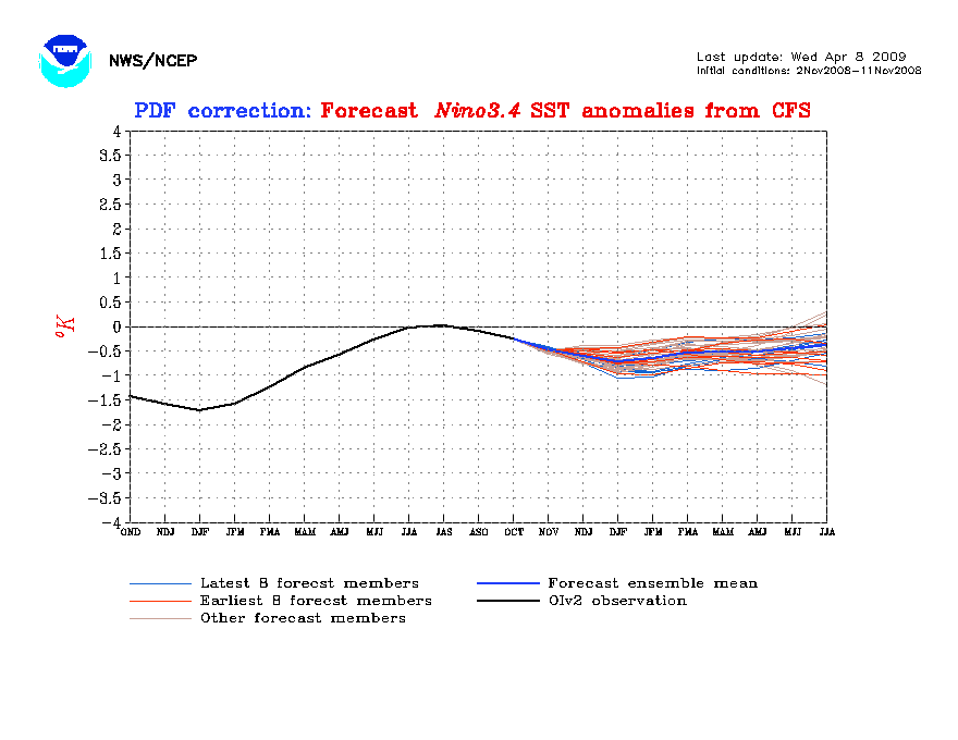
And that's VERY similar to the current forecast for next spring/early summer:
In 2008, the SSTs actually cooled more than was forecast in December, down to -1C. But there certainly was no La Nina in 2009, as you can see by the following graphic:
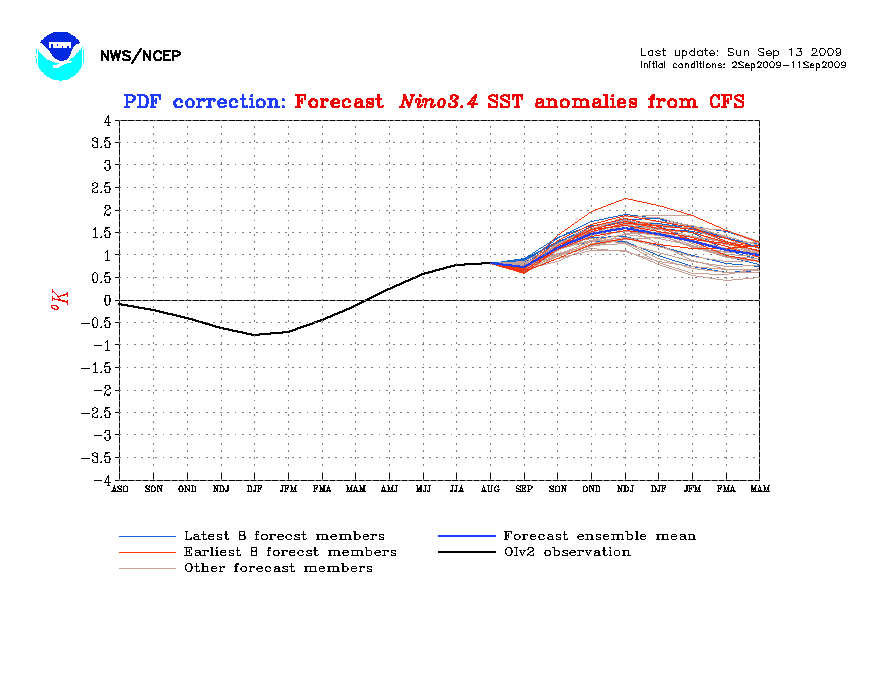
That said, I wouldn't be surprised if SSTs are +.4C to +.7C in Nino 3.4 by next July. That could mean well below the 1995-2011 norms (15/8/4) for 2012. Possibly 10-12 named storms, 5-6 hurricanes and 2-3 intense hurricanes.
And that's VERY similar to the current forecast for next spring/early summer:
In 2008, the SSTs actually cooled more than was forecast in December, down to -1C. But there certainly was no La Nina in 2009, as you can see by the following graphic:
That said, I wouldn't be surprised if SSTs are +.4C to +.7C in Nino 3.4 by next July. That could mean well below the 1995-2011 norms (15/8/4) for 2012. Possibly 10-12 named storms, 5-6 hurricanes and 2-3 intense hurricanes.
0 likes
-
dexterlabio
- Category 5
- Posts: 3519
- Joined: Sat Oct 24, 2009 11:50 pm
Re: Klotzbach/Gray first 2012 forecast
Goodness, the chances of at least a weak El Nino coming in 2012 are pretty high according to the data posted here. Had enough with 2010 El Nino and 2010-2011 La Nina (still ongoing) and their impact. Why can't we just all have a neutral season a bit longer for a change? :<
0 likes
Personal Forecast Disclaimer:
The posts in this forum are NOT official forecast and should not be used as such. They are just the opinion of the poster and may or may not be backed by sound meteorological data. They are NOT endorsed by any professional institution or storm2k.org. For official information, please refer to the NHC and NWS products.
The posts in this forum are NOT official forecast and should not be used as such. They are just the opinion of the poster and may or may not be backed by sound meteorological data. They are NOT endorsed by any professional institution or storm2k.org. For official information, please refer to the NHC and NWS products.

I'm more inclined to agree with Macrocane, I don't think El Nino will come next year but there is a chance. There seems to be predictions frequently about the other extreme coming off of the other. Based on trends, I think it's more likely neutral conditions will appear because it's been a long while since we had a no El-Nino pattern over the span of years. If an El Nino does return next summer then 1. I won't be following tropical cyclones for the first time in years and 2. The suspected increase in El Nino events will be confirmed in my mind.
I'm a bit disappointed in no numbers from them this December, I thought maybe there was some skill but 2004 and 2005 certainly didn't turn out .
.
I'm a bit disappointed in no numbers from them this December, I thought maybe there was some skill but 2004 and 2005 certainly didn't turn out
0 likes
-
wxman57
- Moderator-Pro Met
- Posts: 23175
- Age: 68
- Joined: Sat Jun 21, 2003 8:06 pm
- Location: Houston, TX (southwest)
Re: Klotzbach/Gray first 2012 forecast
Klotzbach DID post most likely numbers (45% chance): 12-15 named storms. 7-9 hurricanes and 3-4 majors. Not exact numbers, but relatively small ranges. I think there could be 9-11 named storms in 2012, but much depends on how many "Jose-types" are named.
1. THC circulation becomes unusually strong in 2012 and no El Niño event occurs (resulting in a seasonal average net tropical cyclone (NTC) activity of ~ 180) – 15% chance.
2. THC continues in the above-average condition it has been in since 1995 and no El Niño develops (NTC ~ 140) – 45% chance.
3. THC continues in above-average condition it has been in since 1995 with the development of a significant El Niño (NTC ~ 75) – 30% chance.
4. THC becomes weaker and there is the development of a significant El Niño (NTC ~ 40) – 10% chance.
Typically, seasons with the above-listed NTC values have TC activity as follows:
180 NTC – 14-17 named storms, 9-11 hurricanes, 4-5 major hurricanes
140 NTC – 12-15 named storms, 7-9 hurricanes, 3-4 major hurricanes
75 NTC – 8-11 named storms, 3-5 hurricanes, 1-2 major hurricanes
40 NTC – 5-7 named storms, 2-3 hurricanes, 0-1 major hurricanes
0 likes
-
MGC

- S2K Supporter

- Posts: 5941
- Joined: Sun Mar 23, 2003 9:05 pm
- Location: Pass Christian MS, or what is left.
Re: Klotzbach/Gray first 2012 forecast
+PDO usually results in fewer and weaker El Nino and more frequent and stronger La Nina conditions. I'm thinking conditions will be neutral in the Pacific, and with a +AMO, we should have another above active 2012 Atlantic hurricane season. We shall see how things go towards summer......MGC
0 likes

Re: Klotzbach/Gray first 2012 forecast
I have a feeling this season will be similar to 1952 or 1992, mostly quiet except for one big hurricane...which hopefully misses land this time!
It's kind of strange, but cool, that going back through the hurricane records, most years ending in "2" have been either quiet or average seasons in storm numbers. However, several of them did bear big single storms. The only exception to the low number of storms seen is the 1932 season, which was quite active. My thought on 2012, is something along the line of 7/4/2.
These numbers don't include BS satellite-era storms like Don or Jose btw. We may see one whopper Category 5 on the other hand!! Just my honest opinion on 2012.
0 likes
Georges '98, Irene '99, Frances '04, Jeanne '04, Katrina '05, Wilma '05, Gustav '08, Isaac '12, Matthew '16, Florence '18, Michael '18, Ian '22
-
cycloneye
- Admin
- Posts: 149746
- Age: 69
- Joined: Thu Oct 10, 2002 10:54 am
- Location: San Juan, Puerto Rico
Re: Klotzbach/Gray first 2012 forecast
IMO,is too early to say for sure how the 2012 season will be in terms of activity as we have to see how ENSO is by the March-April timeframe to then have a better idea if El Nino will be around or not by the summer. That is why the Colorado state team has four alternatives in their December forecast.
0 likes
Visit the Caribbean-Central America Weather Thread where you can find at first post web cams,radars
and observations from Caribbean basin members Click Here
and observations from Caribbean basin members Click Here
-
cycloneye
- Admin
- Posts: 149746
- Age: 69
- Joined: Thu Oct 10, 2002 10:54 am
- Location: San Juan, Puerto Rico
Re: Klotzbach/Gray April 4 Quantitative forecast
Let's see what the CSU team will have in terms of numbers when they release their quantitative forecast around 10:30 AM EDT, but more important is how they see the pattern shaping up with ENSO ,AO,PDO etc.
0 likes
Visit the Caribbean-Central America Weather Thread where you can find at first post web cams,radars
and observations from Caribbean basin members Click Here
and observations from Caribbean basin members Click Here
-
HURRICANELONNY
- Category 5
- Posts: 1392
- Joined: Wed May 07, 2003 6:48 am
- Location: HOLLYWOOD.FL
Re: Klotzbach/Gray 2012 forecasts
Have they ever been right to any extent in April? The SST's are warming. Of course not as warm as last year. I don't think anyone knows how severe this season will be this far out. 
0 likes
hurricanelonny
-
wxman57
- Moderator-Pro Met
- Posts: 23175
- Age: 68
- Joined: Sat Jun 21, 2003 8:06 pm
- Location: Houston, TX (southwest)
Re: Klotzbach/Gray 2012 forecasts
I was talking to Phil about the outlook last week at the NHC. All signals point to diminished activity vs. the past two seasons. Though I didn't see his numbers, I did see that he was thinking 1957 and 1965 were the best analogs, as well as 2001 and 2009. We discussed whether it was possible to ever have less than 10 named storms again based on current detection techniques and naming conventions. I think he'll say either 9 or 10 named storms, 5 hurricanes and 2 majors. I think he was leaning toward 1 major but may start out with 2. I wouldn't be surprised at all if the season is sub-10.
Reasons:
Trend toward El Nino (European is most bullish on El Nino developing over the summer)
Predicted much higher pressures across the Tropical Atlantic this year vs. past 2 years (Euro)
Predicted cooler AMO. Stronger Bermuda high means stronger easterly trades and more upwelling of cool water in the MDR
Note that I'm not talking about seasonal "severity", only seasonal numbers. 1957 and 1965 are the best analogs, and both were seasons of 8 or fewer named storms. However 1957 featured Hurricane Audrey and 1965 featured Betsy. A "quiet" season like either of those two would be quite severe compared to 2010 & 2011.
0 likes
-
Hurricane Andrew

- S2K Supporter
- Posts: 1891
- Age: 27
- Joined: Sun May 23, 2010 2:53 pm
- Location: KS
Who is online
Users browsing this forum: No registered users and 155 guests