See Roger Pielke Jr.'s Blog:
http://rogerpielkejr.blogspot.com/2011/ ... ecord.html
Also, he is co-author on a new paper on global TC landfall trends. Another good read:
http://rogerpielkejr.blogspot.com/2012/ ... lobal.html
From the blog:
"Some interesting statistics of note:
Over 1970 to 2010 the globe averaged about 15 TC landfalls per year
Of those 15, about 5 are intense (Category 3, 4 or 5)
1971 had the most global landfalls with 32, far exceeding the second place, 25 in 1996
1978 had the fewest with 7
2011 tied for second place for the fewest global landfalls with 10 (and 3 were intense, tying 1973, 1981 and 2002)
1999 had the most intense TC landfalls with 9
1981 had the fewest intense TC landfalls with zero
There have been only 8 intense TC landfalls globally since 2008 (2009-2011), very quiet but not unprecedented (two unique 3-year periods saw only 7 intense landfalls)
The US is currently in the midst of the longest streak ever recorded without an intense hurricane landfall"
New US Record - 2232 Days With No Major Hurricane Landfall
Moderator: S2k Moderators
Forum rules

The posts in this forum are NOT official forecasts and should not be used as such. They are just the opinion of the poster and may or may not be backed by sound meteorological data. They are NOT endorsed by any professional institution or STORM2K. For official information, please refer to products from the National Hurricane Center and National Weather Service.
-
WeatherGuesser
- Category 5

- Posts: 2672
- Joined: Tue Jun 29, 2010 6:46 am
-
Scorpion
Re: New US Record - 2232 Days With No Major Hurricane Landfall
Seasons sure have been boring for quite a while now. Can't believe it's been 7 years since the epic season. Sometimes I like to go back to those threads and relive it.
0 likes
-
beoumont

- Category 1

- Posts: 473
- Joined: Sun Jul 10, 2011 4:13 pm
- Location: East Central Florida
- Contact:
Re: New US Record - 2232 Days With No Major Hurricane Landfall
Another "oddity": although S. Florida has the highest probability in the USA of seeing a hurricane in any given year (one in 4 or one in 10, or something in between depending on what criteria one uses ) there were no landfalls there from 1965-1992. 27 years between Betsy and Andrew.
And both of those occurrences, coincidently, were during an El Nino.
And both of those occurrences, coincidently, were during an El Nino.
0 likes
List of 79 tropical cyclones intercepted by Richard Horodner:
http://www.canebeard.com/page/page/572246.htm
http://www.canebeard.com/page/page/572246.htm


-
Bocadude85

- Category 5
- Posts: 2991
- Age: 39
- Joined: Mon Apr 18, 2005 2:20 pm
- Location: Honolulu,Hi
Re: New US Record - 2232 Days With No Major Hurricane Landfall
beoumont wrote:Another "oddity": although S. Florida has the highest probability in the USA of seeing a hurricane in any given year (one in 4 or one in 10, or something in between depending on what criteria one uses ) there were no landfalls there from 1965-1992. 27 years between Betsy and Andrew.
And both of those occurrences, coincidently, were during an El Nino.
Are you talking about major hurricane landfalls or hurricane landfalls in general? Hurricane David made landfall in Palm Beach in 1979.
0 likes
-
HurricaneBill
- Category 5
- Posts: 3419
- Joined: Sun Apr 11, 2004 5:51 pm
- Location: East Longmeadow, MA, USA
Re: New US Record - 2232 Days With No Major Hurricane Landfall
Bocadude85 wrote:beoumont wrote:Another "oddity": although S. Florida has the highest probability in the USA of seeing a hurricane in any given year (one in 4 or one in 10, or something in between depending on what criteria one uses ) there were no landfalls there from 1965-1992. 27 years between Betsy and Andrew.
And both of those occurrences, coincidently, were during an El Nino.
Are you talking about major hurricane landfalls or hurricane landfalls in general? Hurricane David made landfall in Palm Beach in 1979.
Don't forget Hurricane Floyd in 1987.
0 likes
-
beoumont
- Category 1
- Posts: 473
- Joined: Sun Jul 10, 2011 4:13 pm
- Location: East Central Florida
- Contact:
Re: New US Record - 2232 Days With No Major Hurricane Landfall
Bocadude85 wrote:beoumont wrote:Another "oddity": although S. Florida has the highest probability in the USA of seeing a hurricane in any given year (one in 4 or one in 10, or something in between depending on what criteria one uses ) there were no landfalls there from 1965-1992. 27 years between Betsy and Andrew.
And both of those occurrences, coincidently, were during an El Nino.
Are you talking about major hurricane landfalls or hurricane landfalls in general? Hurricane David made landfall in Palm Beach in 1979.
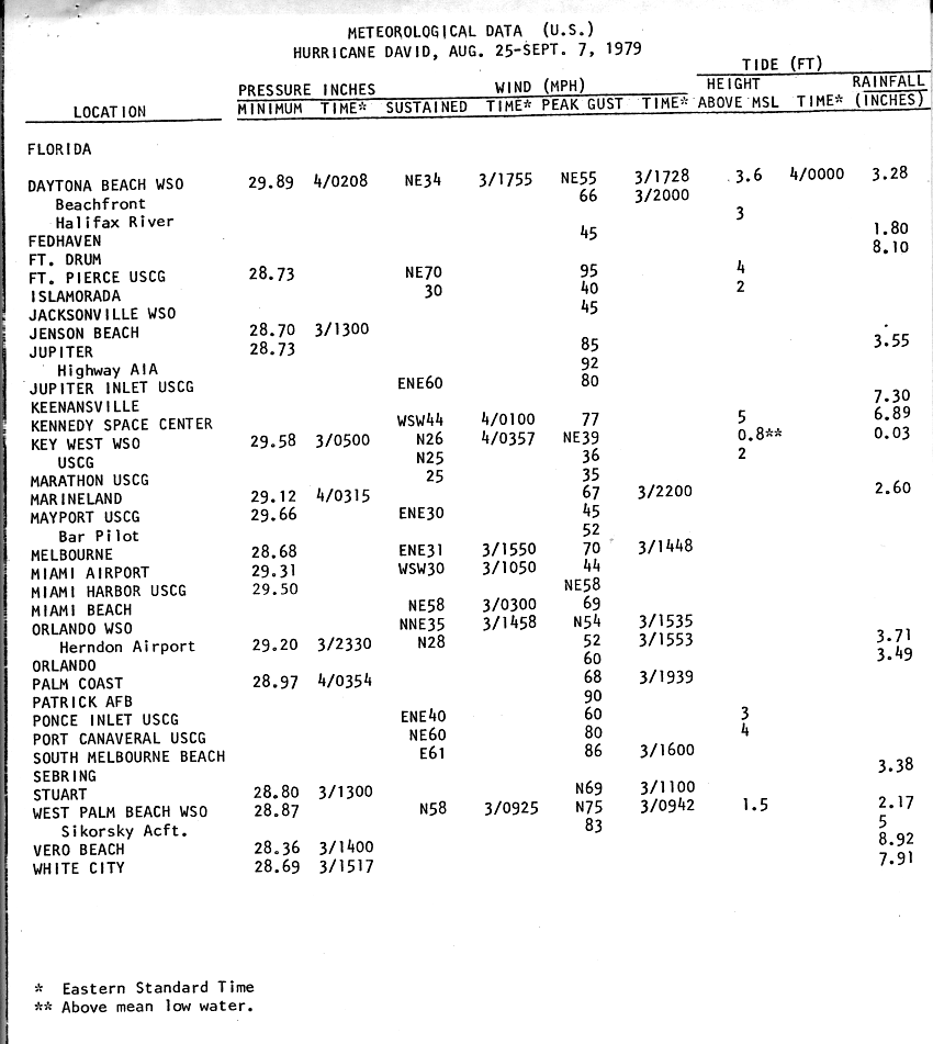
There were no sustained hurricane winds reported in Florida during David's landfall. The highest sustained wind was 70 mph at Ft. Pierce Inlet---and even that is central Florida. There were gusts up to 95 mph reported as the following table from the NHC Preliminary Report shows - again in Central Florida---not sustained.
The Fort Pierce Inlet Coast Guard station is about as exposed to the open water as one can get; and a north or NE wind hits their anemometer just a few feet from the seawall. That very inlet had the highest winds (gust of 111 Knots) when Jeanne made landfall in 2004--even though the eye itself never came over--exact center over Jensen Beach, 17 miles south of there.
http://www.nhc.noaa.gov/archive/storm_wallets/atlantic/atl1979-prelim/david/prelim08.gif
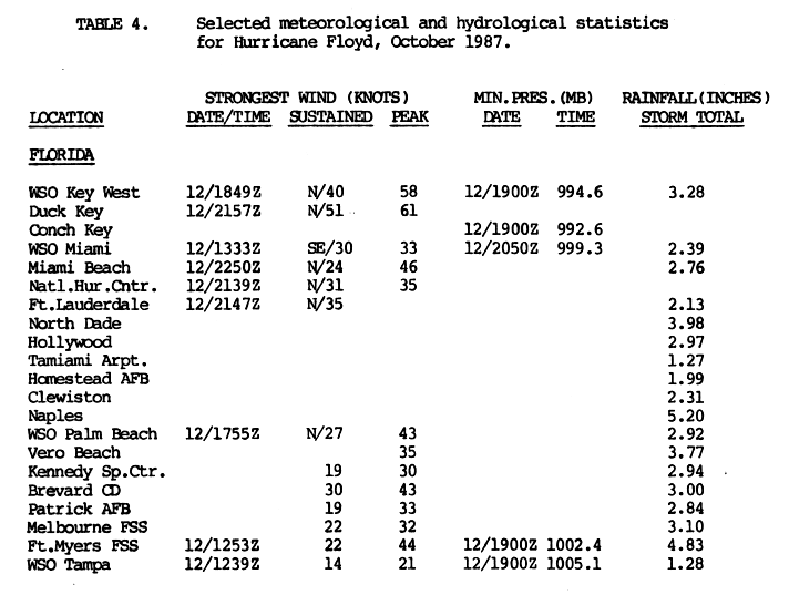
Floyd's highest sustained wind reported was at Duck Key, 51 knots
http://www.nhc.noaa.gov/archive/storm_wallets/atlantic/atl1987-prelim/floyd/prelim11.gif
I "chased" Floyd and was on the Long Key bridge catwalk (2.5 miles from Duck Key) as the concave shaped eye passed over; as a cold front and trough aloft indented the northern "eyewall" inward. I kinda recall some brief gusts we estimated in the 55-60 mph range; as Duck Key is basically just southwest of that bridge.
I also chased David in 1979; but intercepting Frederick in Mobile, AL shortly thereafter was certainly more eventful: equivalent to David vs. Goliath.
If one simply uses the last advisory before landfall, one could say both David and Floyd were hurricanes over Florida, I suppose; but in reality only at the recon. plane flight level over the open ocean.
0 likes
List of 79 tropical cyclones intercepted by Richard Horodner:
http://www.canebeard.com/page/page/572246.htm
http://www.canebeard.com/page/page/572246.htm
-
Bocadude85
- Category 5
- Posts: 2991
- Age: 39
- Joined: Mon Apr 18, 2005 2:20 pm
- Location: Honolulu,Hi
Re: New US Record - 2232 Days With No Major Hurricane Landfall
beoumont wrote:Bocadude85 wrote:beoumont wrote:Another "oddity": although S. Florida has the highest probability in the USA of seeing a hurricane in any given year (one in 4 or one in 10, or something in between depending on what criteria one uses ) there were no landfalls there from 1965-1992. 27 years between Betsy and Andrew.
And both of those occurrences, coincidently, were during an El Nino.
Are you talking about major hurricane landfalls or hurricane landfalls in general? Hurricane David made landfall in Palm Beach in 1979.
There were no sustained hurricane winds reported in Florida during David's landfall. The highest sustained wind was 70 mph at Ft. Pierce Inlet---and even that is central Florida. There were gusts up to 95 mph reported as the following table from the NHC Preliminary Report shows - again in Central Florida---not sustained.
The Fort Pierce Inlet Coast Guard station is about as exposed to the open water as one can get; and a north or NE wind hits their anemometer just a few feet from the seawall. That very inlet had the highest winds (gust of 111 Knots) when Jeanne made landfall in 2004--even though the eye itself never came over--exact center over Jensen Beach, 17 miles south of there.
http://www.nhc.noaa.gov/archive/storm_wallets/atlantic/atl1979-prelim/david/prelim08.gif
Floyd's highest sustained wind reported was at Duck Key, 51 knots
http://www.nhc.noaa.gov/archive/storm_wallets/atlantic/atl1987-prelim/floyd/prelim11.gif
I "chased" Floyd and was on the Long Key bridge catwalk (2.5 miles from Duck Key) as the concave shaped eye passed over; as a cold front and trough aloft indented the northern "eyewall" inward. I kinda recall some brief gusts we estimated in the 55-60 mph range; as Duck Key is basically just southwest of that bridge.
I also chased David in 1979; but intercepting Frederick in Mobile, AL shortly thereafter was certainly more eventful: equivalent to David vs. Goliath.
If one simply uses the last advisory before landfall, one could say both David and Floyd were hurricanes over Florida, I suppose; but in reality only at the recon. plane flight level over the open ocean.
While there may not have been any reports of sustained hurricane force winds there were gusts over hurricane force recorded in Jupiter and West Palm Beach which is in South Florida.
0 likes
-
wxman57

- Moderator-Pro Met

- Posts: 23175
- Age: 68
- Joined: Sat Jun 21, 2003 8:06 pm
- Location: Houston, TX (southwest)
Re: New US Record - 2232 Days With No Major Hurricane Landfall
There's a big difference between sustained TS wind and gusts to hurricane force vs. sustained hurricane force winds gusting to near or over 100 mph. Cat 1 hurricanes rarely produce sustained 74 mph wind over land. Katrina in 2005 was such a rarity as it crossed south Florida, mainly because it was in a strengthening phase at that time.
Of course, the above record is only as good as the best track database. There could have been longer periods between Cat 3 or higher landfalls, as most landfall intensities are somewhat questionable before the modern age of instrumentation.
Of course, the above record is only as good as the best track database. There could have been longer periods between Cat 3 or higher landfalls, as most landfall intensities are somewhat questionable before the modern age of instrumentation.
0 likes
-
beoumont
- Category 1
- Posts: 473
- Joined: Sun Jul 10, 2011 4:13 pm
- Location: East Central Florida
- Contact:
Re: New US Record - 2232 Days With No Major Hurricane Landfall
wxman57 wrote:There's a big difference between sustained TS wind and gusts to hurricane force vs. sustained hurricane force winds gusting to near or over 100 mph. Cat 1 hurricanes rarely produce sustained 74 mph wind over land. Katrina in 2005 was such a rarity as it crossed south Florida, mainly because it was in a strengthening phase at that time.
Of course, the above record is only as good as the best track database. There could have been longer periods between Cat 3 or higher landfalls, as most landfall intensities are somewhat questionable before the modern age of instrumentation.
Ok, true.
Under any criteria, though, the greater Miami or Ft. Lauderdale areas did not experience a hurricane or even gusts of hurricane force for those 27 years between 1965 and 1992.
Instead, though, there were frequent Hurricane occurrences during those same years in the Orange Bowl, where the Univ. of Miami Hurricanes football team won 4 National Championships. (1983, 1987, 1989, 1991.).
And speaking of oddities and Katrina in S. Florida: for those who assume the strongest winds of a hurricane are "always" in the NE quadrant; the SE quadrant was the most intense, if I recall correctly, as Katrina moved southwestward across Florida. That was in the left front quadrant.
0 likes
List of 79 tropical cyclones intercepted by Richard Horodner:
http://www.canebeard.com/page/page/572246.htm
http://www.canebeard.com/page/page/572246.htm
-
brunota2003

- S2K Supporter

- Posts: 9476
- Age: 35
- Joined: Sat Jul 30, 2005 9:56 pm
- Location: Stanton, KY...formerly Havelock, NC
- Contact:

Re: New US Record - 2232 Days With No Major Hurricane Landfall
US Major Hurricane Landfall Since 1980
1980-Allen
1981-None
1982-None
1983-Alicia
1984-None
1985-Elena, Kate
1986-None
1987-None
1988-None
1989-Hugo
1990-None
1991-None
1992-Andrew
1993 Emily (Eyewall Landfall)
1994-None
1995-Opal
1996-Fran
1997-None
1998-None
1999-Bret
2000-None
2001-None
2002-None
2003-None
2004-Charley, Ivan, Jeanne
2005-Dennis, Katrina, Rita, Wilma
2006-None
2007-None
2008-None
2009-None
2010-None
2011-None
Even when the Atlantic was in a cool phase, we saw more major hurricane landfalls than right now. This is the longest period with major hurricane landfall on America, almost 7 years. The other long gap is 1999 to 2004, which is 5 years. That did not bode well.
0 likes
-
CrazyC83
- Professional-Met

- Posts: 34316
- Joined: Tue Mar 07, 2006 11:57 pm
- Location: Deep South, for the first time!
Re: New US Record - 2232 Days With No Major Hurricane Landfall
Ptarmigan wrote:US Major Hurricane Landfall Since 1980
1980-Allen
1981-None
1982-None
1983-Alicia
1984-None
1985-Elena, Kate
1986-None
1987-None
1988-None
1989-Hugo
1990-None
1991-None
1992-Andrew
1993 Emily (Eyewall Landfall)
1994-None
1995-Opal
1996-Fran
1997-None
1998-None
1999-Bret
2000-None
2001-None
2002-None
2003-None
2004-Charley, Ivan, Jeanne
2005-Dennis, Katrina, Rita, Wilma
2006-None
2007-None
2008-None
2009-None
2010-None
2011-None
Even when the Atlantic was in a cool phase, we saw more major hurricane landfalls than right now. This is the longest period with major hurricane landfall on America, almost 7 years. The other long gap is 1999 to 2004, which is 5 years. That did not bode well.
Of those, Kate was not a major at landfall and Alicia IMO was questionable, even though it is currently sitting as a major on HURDAT (I would knock it down to Cat 2 at landfall).
Even lower-category storms can be really destructive though!
0 likes
-
beoumont
- Category 1
- Posts: 473
- Joined: Sun Jul 10, 2011 4:13 pm
- Location: East Central Florida
- Contact:
Re:
brunota2003 wrote:The strongest winds are almost always in the Right Front Quadrant based off of direction of movement, not NE (NE side of a storm would apply to a N or NE moving storm). So, a SW moving storm would typically have the strongest winds in the NW to SW side of the storm (roughly).
You are correct in that the right front quadrant of a SW moving storm is the NW quadrant; and a majority (but not a vast majority at landfall) of the time the right front quadrant contains the strongest winds -- not necessarily the NE quadrant. As I noted above, Katrina's strongest winds at Florida landfall were in the Left Front quadrant.
Experience and observation have shown me that "typical" or textbook would be more accurate words than "almost always". About 1/3 of the time, at landfall in the USA at least, this has not proven the case during my period of direct observation, 1965-present.
Offhand, another example of these 1/3 of the time, besides Katrina in Florida, was Isabel of 2003 that had its strongest winds in the Left Front quadrant, NW of the eye at landfall, as the storm moved NNW.
What is the cause or causes of these landfalling hurricanes that do not fit the textbook model? Sometimes a "vort max" is rotating around the eyewall as in Isabel this was on the NW side at landfall. Or, land friction can distort the pressure gradient, or angle of approach to land can do the same thing, eroding the eyewall on the landward side of the approaching eye. Or, the timing of an eyewall replacement cycle near or at landfall. Or, the approach of a trough aloft or simply dry air impeding the structure on one side of the storm. Or rapidly decreasing water temps in front of the path of the storm.
And these are some of the things that make the study of hurricanes so fascinating: no two are exactly alike.
-----------------
Yes, Kate was certainly not a major at landfall; as it was passing over very cool waters in the northern Gulf as is typical in late November. It did have a distinct eye; but the tops of the clouds in the eyewall were in the 28,000 foot range. The highest gusts I saw at Mexico Beach,FL just before the eye were in the 85-90 mph range; and there were higher gusts at Cape San Blas near Appalachicola. Across the whole breadth of the eye the wind at landfall never dropped below 25-30 mph---I guess a graphic example of a hurricane "filling". I also recall that when leaving Biloxi, Ms the morning of landfall, the temperature was 55 degrees, west of the cold front Kate was riding NE ahead of.
Last edited by beoumont on Sat Feb 18, 2012 2:47 am, edited 2 times in total.
0 likes
List of 79 tropical cyclones intercepted by Richard Horodner:
http://www.canebeard.com/page/page/572246.htm
http://www.canebeard.com/page/page/572246.htm
-
somethingfunny

- ChatStaff

- Posts: 3926
- Age: 37
- Joined: Thu May 31, 2007 10:30 pm
- Location: McKinney, Texas
Re: New US Record - 2232 Days With No Major Hurricane Landfall
I'll take it a step further and go to 1970.
US Major Hurricane Landfall Since 1970
1970-Celia
1971-None
1972-None
1973-None
1974-Carmen
1975-Eloise
1976-None
1977-None
1978-None
1979-Frederic
1980-Allen
1981-None
1982-None
1983-Alicia
1984-None
1985-Elena
1986-None
1987-None
1988-None
1989-Hugo
1990-None
1991-None
1992-Andrew
1993 Emily (Eyewall Landfall)
1994-None
1995-Opal
1996-Fran
1997-None
1998-None
1999-Bret
2000-None
2001-None
2002-None
2003-None
2004-Charley, Ivan, Jeanne
2005-Dennis, Katrina, Rita, Wilma
2006-None
2007-None
2008-None
2009-None
2010-None
2011-None
Over 42 years we had 20 major hurricane landfalls in the US.... roughly one every other year. But 7 of them were in 2004-2005. Take those out and you have a 40 year sample with 13 major US landfalls, one every 3 years roughly. I don't think we'll escape one this year, but it really wouldn't be too surprising if we did. It's about a 30% chance each year historically, minus that crazy statistical anomaly of 2004-2005 which I think skewed the perspectives for a lot of us.
0 likes
I am not a meteorologist, and any posts made by me are not official forecasts or to be interpreted as being intelligent. These posts are just my opinions and are probably silly opinions.
-
brunota2003
- S2K Supporter
- Posts: 9476
- Age: 35
- Joined: Sat Jul 30, 2005 9:56 pm
- Location: Stanton, KY...formerly Havelock, NC
- Contact:
-
beoumont
- Category 1
- Posts: 473
- Joined: Sun Jul 10, 2011 4:13 pm
- Location: East Central Florida
- Contact:
Re:
brunota2003 wrote:Isabel's strongest winds were in the NE side, or RFQ. Cherry Point had sustained winds (2 min. average) of 33 mph with a gust to 71 mph, while Duck was 69 mph, with a peak gust of 92 mph. Also, Ocracoke had a peak gust to 105 mph.
As you noted, the "RECORDED" wind gusts were a couple of mph higher at those stations (likely 30 ft or so above the surface) that you mentioned than at Elizabeth city; but again, the damage path increased and was greater many miles west of there. My observation when driving that area indicated wind damage 10-15 mph greater than at Elizabeth City; depicted by a several mile stretch of mostly flattened and completely stripped forest east and southeast of Edenton. The damage observed grew obviously greater as one got west of Elizabeth City.
The strongest wind damage was between Elizabeth City and Edenton, closer to Edenton; based on surface and aerial surveys. There were gusts of 100 mph in Elizabeth City, and 110-115 mph just east of Edenton - the damage path strongly indicated. There was a Clemson tower near where we were located in Elizabeth City and it recorded a 97 mph gust. (84 kts.).
I personally spoke with the recon. communication officer at the NHC as the eye approached Ocracoke, and he informed me the recon. radar showed a bomb going off on the NW side of the eye - hence that is where we traveled at his suggestion and observed a gust of 100 mph (on the video below) right on the river in Elizabeth City. There is no recording station in or near that wooded area near Edenton; but, again, damage surveys showed that is where the worst wind damage occurred.
There was also a 7 foot tidal surge at downtown Elizabeth City.
Regardless of which set of numbers one accepts, the measured ones, or the wind estimates derived from the damage path; below is a short video shot at Elizabeth City for your enjoyment. The satellite loops are spectacular; including the ones with the wagon-wheel spinning inside the eye.
http://www.youtube.com/watch?v=hn0FyXxxweQ
Last edited by beoumont on Sat Feb 18, 2012 3:07 pm, edited 3 times in total.
0 likes
List of 79 tropical cyclones intercepted by Richard Horodner:
http://www.canebeard.com/page/page/572246.htm
http://www.canebeard.com/page/page/572246.htm
Re: New US Record - 2232 Days With No Major Hurricane Landfall
CrazyC83 wrote:Of those, Kate was not a major at landfall and Alicia IMO was questionable, even though it is currently sitting as a major on HURDAT (I would knock it down to Cat 2 at landfall).
Even lower-category storms can be really destructive though!
The highest sustained winds measured in Alicia on land was 96 mph with gust of 127 mph. Over water, it was likely stronger.
0 likes
Re: New US Record - 2232 Days With No Major Hurricane Landfall
I think this data shows the inherent limitations in the current system used to categorize hurricanes - that is wind speed alone. If we look at surge, the U.S. clearly had a surge event that is typical of a major hurricane making landfall with Hurricane Ike in 2008. Surge values reached 20' in Texas...although Ike was technically a Category 2 at landfall. According to the orignal Saffir Simpson scale which had wind and surge value ranges, a surge of 18+ feet constitutes a Category 5 storm!
It is a huge omission to at least note Ike in 2008 on this list of landfalling majors...a surge event typical of a Cat 5 surely deserves a mention:
2000-None
2001-None
2002-None
2003-None
2004-Charley, Ivan, Jeanne
2005-Dennis, Katrina, Rita, Wilma
2006-None
2007-None
2008-Ike (surge)
2009-None
2010-None
2011-None
The NHC has issued the following discussion in conjunction with the explanation they provide on the Saffir Simpson scale:
The scale does not address the potential for other hurricane-related impacts, such as storm surge, rainfall-induced floods, and tornadoes. It should also be noted that these wind-caused damage general descriptions are to some degree dependent upon the local building codes in effect and how well and how long they have been enforced. For example, building codes enacted during the 2000s in Florida, North Carolina and South Carolina are likely to reduce the damage to newer structures from that described below. However, for a long time to come, the majority of the building stock in existence on the coast will not have been built to higher code. Hurricane wind damage is also very dependent upon other factors, such as duration of high winds, change of wind direction, and age of structures.
Earlier versions of this scale – known as the Saffir-Simpson Hurricane Scale – incorporated central pressure and storm surge as components of the categories. The central pressure was used during the 1970s and 1980s as a proxy for the winds as accurate wind speed intensity measurements from aircraft reconnaissance were not routinely available for hurricanes until 1990[5]. Storm surge was also quantified by category in the earliest published versions of the scale dating back to 1972[6]. However, hurricane size (extent of hurricane-force winds), local bathymetry (depth of near-shore waters), topography, the hurricane.s forward speed and angle to the coast also affect the surge that is produced[7],[8]. For example, the very large Hurricane Ike (with hurricane force winds extending as much as 125 mi from the center) in 2008 made landfall in Texas as a Category 2 hurricane and had peak storm surge values of about 20 ft. In contrast, tiny Hurricane Charley (with hurricane force winds extending at most 25 mi from the center) struck Florida in 2004 as a Category 4 hurricane and produced a peak storm surge of only about 7 ft. These storm surge values were substantially outside of the ranges suggested in the original scale.
http://www.nhc.noaa.gov/sshws.shtml
0 likes
Who is online
Users browsing this forum: No registered users and 83 guests