
I think we are 6 weeks too early to be looking at this but here it is.
http://www.ssd.noaa.gov/goes/east/watl/flash-avn.html
I thought for sure someone would of posted about this by now.
Area in Caribbean
Moderator: S2k Moderators
Forum rules

The posts in this forum are NOT official forecasts and should not be used as such. They are just the opinion of the poster and may or may not be backed by sound meteorological data. They are NOT endorsed by any professional institution or STORM2K. For official information, please refer to products from the National Hurricane Center and National Weather Service.
Area in Caribbean
0 likes

Yeah a bit too early to think that something tropical or subtropical may come out of this but it will at least bring some very heavy rains to Cuba, Bahamas and possibly SE FL.
Interesting part is that at least the GFS leave pressures somewhat low through its long range forecast so maybe something else to watch as we head into May.
Interesting part is that at least the GFS leave pressures somewhat low through its long range forecast so maybe something else to watch as we head into May.
0 likes
Re: Area in Caribbean
The Miami and Key West NWS discussions were saying that the area is moving NW but when I look at it it looks like its moving NNE bypassing Florida to the East.
0 likes
-
cycloneye

- Admin

- Posts: 149746
- Age: 69
- Joined: Thu Oct 10, 2002 10:54 am
- Location: San Juan, Puerto Rico
Re: Area in Caribbean
I thought for sure someone would of posted about this by now.
I dont understand why the Talking Tropics forum is very slow on members participating so far in 2012 in the different topics,poll etc. But you made the thread for this area that may turn interesting if the 60kt shear leds up.
0 likes
Visit the Caribbean-Central America Weather Thread where you can find at first post web cams,radars
and observations from Caribbean basin members Click Here
and observations from Caribbean basin members Click Here
-
cycloneye
- Admin
- Posts: 149746
- Age: 69
- Joined: Thu Oct 10, 2002 10:54 am
- Location: San Juan, Puerto Rico
Re: Area in Caribbean
This is the 18z Surface analysis.

0 likes
Visit the Caribbean-Central America Weather Thread where you can find at first post web cams,radars
and observations from Caribbean basin members Click Here
and observations from Caribbean basin members Click Here
Re: Area in Caribbean
cycloneye wrote:I thought for sure someone would of posted about this by now.
I dont understand why the Talking Tropics forum is very slow on members participating so far in 2012 in the different topics,poll etc. But you made the thread for this area that may turn interesting if the 60kt shear leds up.
I do not know why either. Just because there is the possibility of an El Nino during the heart of the hurricane season it does not mean that we could not have an ealier & busier than normal start to the season, we have a cool Neutral ENSO right now with average conditions across the Caribbean & GOM. Compared to last year, instability is a bit higher across the Caribbean & GOM so that's where we may see some early action during the month of May.
0 likes
-
MGC

- S2K Supporter

- Posts: 5941
- Joined: Sun Mar 23, 2003 9:05 pm
- Location: Pass Christian MS, or what is left.
Re: Area in Caribbean
Upper level winds still look rather brisk down in the NW Caribbean....of course we are not far from May and if there is early season development it will likely occur that area....MGC
0 likes
Re: Area in Caribbean
I hope we get some rains out of it. We have been lucky this dry season with a couple nice soaks. It's cool looking at the drought index map in April, and NOT seeing orange and red over South Florida.
0 likes

Shades of the 2012 Hurricane Season.....its on the way.
0 likes
The following post is NOT an official forecast and should not be used as such. It is just the opinion of the poster and may or may not be backed by sound meteorological data. It is NOT endorsed by any professional institution including storm2k.org For Official Information please refer to the NHC and NWS products.
-
Aric Dunn
- Category 5

- Posts: 21238
- Age: 43
- Joined: Sun Sep 19, 2004 9:58 pm
- Location: Ready for the Chase.
- Contact:
I was anticipating this area since I saw the forecast for the low/ trough last week that developed in the gulf. The trailing trough would push to the sw carrib. very classic early june set up except the system was a little farther south than normal for this time a year. but my first thought was to watch the sw carrib given the ridging that was forecast to set up after. the upper environment is not conducive atm but should aid in the development of convention for the next couple days... afterwards if it persists then things may be at least marginally conducive.
0 likes
Note: If I make a post that is brief. Please refer back to previous posts for the analysis or reasoning. I do not re-write/qoute what my initial post said each time.
If there is nothing before... then just ask
Space & Atmospheric Physicist, Embry-Riddle Aeronautical University,
I believe the sky is falling...
If there is nothing before... then just ask
Space & Atmospheric Physicist, Embry-Riddle Aeronautical University,
I believe the sky is falling...
Re: Area in Caribbean
I don't think Floridais going to get a drop of rain out of tis its just missing us to the East.
0 likes
Re: Area in Caribbean
GFS is still persistent in this disturbance dumping close to 5" of rain in S FL.
http://mag.ncep.noaa.gov/NCOMAGWEB/appc ... mageSize=M
http://mag.ncep.noaa.gov/NCOMAGWEB/appc ... mageSize=M
0 likes
-
SFLcane

- S2K Supporter
- Posts: 10281
- Age: 48
- Joined: Sat Jun 05, 2010 1:44 pm
- Location: Lake Worth Florida
Re: Area in Caribbean
NDG wrote:GFS is still persistent in this disturbance dumping close to 5" of rain in S FL.
http://mag.ncep.noaa.gov/NCOMAGWEB/appc ... mageSize=M
Still up for question but it looks like most of the heavy rainfall might stay just to the east of south florida as per the GFS.

0 likes
-
Dean4Storms
- S2K Supporter
- Posts: 6358
- Age: 63
- Joined: Sun Aug 31, 2003 1:01 pm
- Location: Miramar Bch. FL
Re: Area in Caribbean
SFLcane wrote:NDG wrote:GFS is still persistent in this disturbance dumping close to 5" of rain in S FL.
http://mag.ncep.noaa.gov/NCOMAGWEB/appc ... mageSize=M
Still up for question but it looks like most of the heavy rainfall might stay just to the east of south florida as per the GFS.
I was going by the 12z GFS run which had some of the heaviest QFP over S FL over the next 5-6 days.

0 likes
-
gatorcane

- S2K Supporter
- Posts: 23708
- Age: 48
- Joined: Sun Mar 13, 2005 3:54 pm
- Location: Boca Raton, FL
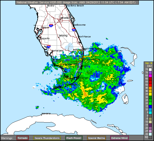
I have been watching this area for several days and was thinking most of the activity will stay east of Florida and into the Bahamas. At least today that looks to be true but there have been some localized heavy rains in South Florida overnight and this morning. It's important to note the trough is moving NW at the lower-levels but the shear at the upper-levels is blowing from the SSW making it appear the area is lifting out to the NNE.
Looking at the latest visible loops it appears that the is a low forming in the NW Caribbean along the trough and moving NNW. The shear is obviously very high especially north of the Caribbean but I do think there could be a good chance of some heavy rainfall across South Florida tonight and tomorrow as there is a new convection surge moving up from Cuba. South Florida will be on the "dirty" side of the low if that ends up being the primary low. I can see some of the models are trying to eventually develop a low east of Florida and into the Bahamas on the northern part of the trough axis. In that case, there will be much less rainfall across South Florida.
Development chances remain low due to shear and also all of the dry air that is over the GOM and Western NW Caribbean as seen by the latest WV loops.
0 likes
-
Dean4Storms
- S2K Supporter
- Posts: 6358
- Age: 63
- Joined: Sun Aug 31, 2003 1:01 pm
- Location: Miramar Bch. FL
Re: Area in Caribbean
6z GFS still showing a low briefly closing off over the FL Staits and sliding westward.....
http://policlimate.com/weather/current/ ... recip.html
http://policlimate.com/weather/current/ ... recip.html
0 likes
As promised by the models, looks like a fairly rainy day in S FL, mid level vorticity has continued to move out of the Caribbean into the FL Straights this morning, with a possible lower vorticity developing just south of the Keys this morning.

The GFS in 3 runs in row has been forecasting at least 5" of rain in SE FL with the possibility of 10" in a spot or two over the next 48 hrs.
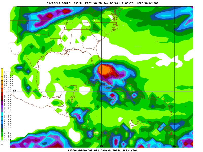
The GFS in 3 runs in row has been forecasting at least 5" of rain in SE FL with the possibility of 10" in a spot or two over the next 48 hrs.
0 likes
-
northjaxpro

- S2K Supporter
- Posts: 8900
- Joined: Mon Sep 27, 2010 11:21 am
- Location: Jacksonville, FL
There are reports already across areas in Dade and Broward counties of over 2 inches of rain which has already occured this morning. Flooding will likely be a problem down there as the day progresses.
I wish that rain would head northbound into the central and northern portions of the peninsula, but a low level ridge is sitting directly over the Southeastern CONUS. This will keep that moisture confined over the exterme southern peninsula for the next several days for the unfortunate who desperately need the rain.
I wish that rain would head northbound into the central and northern portions of the peninsula, but a low level ridge is sitting directly over the Southeastern CONUS. This will keep that moisture confined over the exterme southern peninsula for the next several days for the unfortunate who desperately need the rain.
0 likes
NEVER, EVER SAY NEVER in the tropics and weather in general, and most importantly, with life itself!!
________________________________________________________________________________________
Fay 2008 Beryl 2012 Debby 2012 Colin 2016 Hermine 2016 Julia 2016 Matthew 2016 Irma 2017 Dorian 2019
________________________________________________________________________________________
Fay 2008 Beryl 2012 Debby 2012 Colin 2016 Hermine 2016 Julia 2016 Matthew 2016 Irma 2017 Dorian 2019
I think we have a very weak hybrid in the making, with a weak surface low now developing.
http://rammb.cira.colostate.edu/ramsdis ... _floater_1
http://rammb.cira.colostate.edu/ramsdis ... _floater_1
0 likes
Who is online
Users browsing this forum: No registered users and 157 guests